

Cow Corner
Encyclopedia
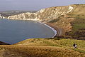
Worbarrow Bay
Worbarrow Bay is a large broad and shallow bay just to the east of Lulworth Cove on the Isle of Purbeck, Dorset, England.- Location :Worbarrow Bay is located about six kilometres south of Wareham and about 16 kilometres west of Swanage. At the eastern end of the Bay is a promontory known as...
, a small secluded bay on the south coast of the Isle of Purbeck
Isle of Purbeck
The Isle of Purbeck, not a true island but a peninsula, is in the county of Dorset, England. It is bordered by the English Channel to the south and east, where steep cliffs fall to the sea; and by the marshy lands of the River Frome and Poole Harbour to the north. Its western boundary is less well...
, in Dorset
Dorset
Dorset , is a county in South West England on the English Channel coast. The county town is Dorchester which is situated in the south. The Hampshire towns of Bournemouth and Christchurch joined the county with the reorganisation of local government in 1974...
England
England
England is a country that is part of the United Kingdom. It shares land borders with Scotland to the north and Wales to the west; the Irish Sea is to the north west, the Celtic Sea to the south west, with the North Sea to the east and the English Channel to the south separating it from continental...
.
Location
Worbarrow Bay and Cow Corner are located about six kilometres south of WarehamWareham, Dorset
Wareham is an historic market town and, under the name Wareham Town, a civil parish, in the English county of Dorset. The town is situated on the River Frome eight miles southwest of Poole.-Situation and geography:...
und about 16 kilometres west of Swanage
Swanage
Swanage is a coastal town and civil parish in the south east of Dorset, England. It is situated at the eastern end of the Isle of Purbeck, approximately 10 km south of Poole and 40 km east of Dorchester. The parish has a population of 10,124 . Nearby are Ballard Down and Old Harry Rocks,...
. The bay lies directly south of the ghost village
Ghost town
A ghost town is an abandoned town or city. A town often becomes a ghost town because the economic activity that supported it has failed, or due to natural or human-caused disasters such as floods, government actions, uncontrolled lawlessness, war, or nuclear disasters...
of Tyneham
Tyneham
Tyneham is a ghost village in south Dorset, England, near Lulworth on the Isle of Purbeck. It remains a civil parish.-Location:The village is situated northeast of Worbarrow Bay on the Jurassic Coast, about south of Wareham and about west of Swanage. It is part of the Lulworth Estate. Tyneham is...
. Access to Cow Corner is solely possible by foot when the Lulworth
Lulworth
Lulworth is the popular name for an area on the coast of Dorset, South West England notable for its castle and cove. However there is no actual place or feature called simply "Lulworth", the villages are East and West Lulworth and the coastal feature is Lulworth Cove.See:*East Lulworth *Lulworth...
army firing ranges are open to the public, either from Tyneham, or alternatively via the South West Coast Path
South West Coast Path
The South West Coast Path is Britain's longest waymarked long-distance footpath and a National Trail. It stretches for , running from Minehead in Somerset, along the coasts of Devon and Cornwall, to Poole Harbour in Dorset. Since it rises and falls with every river mouth, it is also one of the more...
.
Jurassic Coast
The Jurassic CoastJurassic Coast
The Jurassic Coast is a World Heritage Site on the English Channel coast of southern England. The site stretches from Orcombe Point near Exmouth in East Devon to Old Harry Rocks near Swanage in East Dorset, a distance of ....
is a World Heritage Site
World Heritage Site
A UNESCO World Heritage Site is a place that is listed by the UNESCO as of special cultural or physical significance...
. The coastal exposures along the Jurassic coastline provide a continuous sequence of Triassic
Triassic
The Triassic is a geologic period and system that extends from about 250 to 200 Mya . As the first period of the Mesozoic Era, the Triassic follows the Permian and is followed by the Jurassic. Both the start and end of the Triassic are marked by major extinction events...
, Jurassic
Jurassic
The Jurassic is a geologic period and system that extends from about Mya to Mya, that is, from the end of the Triassic to the beginning of the Cretaceous. The Jurassic constitutes the middle period of the Mesozoic era, also known as the age of reptiles. The start of the period is marked by...
and Cretaceous
Cretaceous
The Cretaceous , derived from the Latin "creta" , usually abbreviated K for its German translation Kreide , is a geologic period and system from circa to million years ago. In the geologic timescale, the Cretaceous follows the Jurassic period and is followed by the Paleogene period of the...
rock formations spanning approximately 185 million years of the Earths history. The rocks along the Jurassic Coast dip gently to the east. Due to this tilting and due to erosion the oldest exposed rocks are found in the west. The younger Cretaceous rocks form the cliffs here in the east. Cow Corner and Worbarrow Bay are part of the Jurassic Coast.
- For further Jurassic sites see: List of places on the Jurassic Coast
Geology
The geology of the Isle of Purbeck is very complex and this is shown very clearly along this stretch of coast. The northern side of Worbarrow Bay is mainly Upper and Middle Chalk. This is subject to frequent landslides because of the unstable underlying Gault ClayGault Clay
Gault is a clay formation of stiff blue clay deposited in a calm, fairly deep water marine environment during the Lower Cretaceous Period...
. At the top of the cliffs is the Iron Age
Iron Age
The Iron Age is the archaeological period generally occurring after the Bronze Age, marked by the prevalent use of iron. The early period of the age is characterized by the widespread use of iron or steel. The adoption of such material coincided with other changes in society, including differing...
hill fort
Hill fort
A hill fort is a type of earthworks used as a fortified refuge or defended settlement, located to exploit a rise in elevation for defensive advantage. They are typically European and of the Bronze and Iron Ages. Some were used in the post-Roman period...
on Flower's Barrow
Flower's Barrow
Flower’s Barrow is an Iron Age hillfort, built over 2500 years ago, above Worbarrow Bay in Dorset on the south coast of England.- Location :Flower’s Barrow is located about 16 kilometres from Swanage and about six kilometres south of Wareham....
, which is threatened by erosion on its seaward side. The Flower's Barrow ridge forms the western end of the ridge which runs all the way to Ballard Point north of Swanage
Swanage
Swanage is a coastal town and civil parish in the south east of Dorset, England. It is situated at the eastern end of the Isle of Purbeck, approximately 10 km south of Poole and 40 km east of Dorchester. The parish has a population of 10,124 . Nearby are Ballard Down and Old Harry Rocks,...
. The Chalk cliffs become lower to the west of Cow Corner and just beyond they form a knife-edge ridge that drops down to the little Bay of Arish Mell, where a stream has cut a gap in the Cretaceous hills.
The steep angular layers of rock are clearly visible in the cliffs of the bay. They reveal complex sedimentary folding, that deranged the geology of this neighbourhood about 30 million years ago, caused by the tectonic pressures as the African and European continents collided. The rock sediments were twisted horizontally and this is why the Chalks that are between 85 to 145 million years old are found at the rear of the bay.
The sediments that form Mupe Ledges and Worbarrow Tout
Worbarrow Tout
Worbarrow Tout is a promontory at the eastern end of Worbarrow Bay on Isle of Purbeck in Dorset on the south coast of England.- Location :Worbarrow Bay and Worbarrow Tout are located about six kilometres south of Wareham und about 16 kilometres west of Swanage. Worbarrow Bay lies between Kimmeridge...
are the 150 million year old Portland Limestones and the 147 million year old Purbeck Beds.