

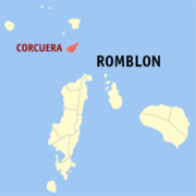
Corcuera, Romblon
Encyclopedia
Philippines
The Philippines , officially known as the Republic of the Philippines , is a country in Southeast Asia in the western Pacific Ocean. To its north across the Luzon Strait lies Taiwan. West across the South China Sea sits Vietnam...
, located in the Simara Island. According to the 2000 census, it has a population of 10,972 people in 2,270 households. It was named after the Spanish governor-general
Governor-General of the Philippines
The Governor-General of the Philippines was the title of the government executive during the colonial period of the Philippines, governed mainly by Spain and the United States, and briefly by Great Britain, from 1565 to 1935....
Sebastian Hurtado de Corcuera
Sebastián Hurtado de Corcuera
Sebastián Hurtado de Corcuera was a Spanish soldier and colonial official. From 1632 to 1634 he was governor of Panama. From June 25, 1635 to August 11, 1644 he was governor of the Philippines. And from 1659 to his death in 1660 he was governor of the Canary Islands...
who ruled from 1635 to 1644.
Barangays
Corcuera is politically subdivided into 15 barangayBarangay
A barangay is the smallest administrative division in the Philippines and is the native Filipino term for a village, district or ward...
s.
- Alegria
- Ambulong
- Colongcolong
- Gobon
- Guintiguiban
- Ilijan
- Labnig
- Mabini
- Mahaba
- Mangansag
- Poblacion
- San Agustin
- San Roque
- San Vicente
- Tacasan
Population of Corcuera at various times
| Barrio/Barangay Name |
Land Area (Hectares) |
1894 |
1896 /c |
1903 /h |
1918 /a |
1939 |
1948 |
1960 |
1970 |
1975 |
1980 |
1990 |
1995 |
2000 |
2007 /j |
|---|---|---|---|---|---|---|---|---|---|---|---|---|---|---|---|
| San Jose (Poblacion) |
118 | ||||||||||||||
| San Isidro (Poblacion) |
130 | ||||||||||||||
| San Miguel (Poblacion) |
117 | ||||||||||||||
| San Pedro (Poblacion) |
135 | ||||||||||||||
| San Roque (Poblacion) |
133 | ||||||||||||||
| Poblacion (U) | 13.72 | 1,892 | 510 | 564 | 597 | 735 | 545 | 512 | 572 | 562 | 610 | 626 | |||
| Alegria | 251.59 | 219 | 464 | 574 | 913 | 1,098 | 1,216 | 1,459 | 1,436 | 1,366 | 1,595 | 1,677 | |||
| Ambulong | 136.72 | 312 | 235 | 256 | 452 | 429 | 476 | 382 | 427 | 447 | 455 | ||||
| Bagadolong /f | 117 | ||||||||||||||
| Colongcolong | 125.36 | 128 | 133 | 249 | 385 | 219 | 468 | 479 | 621 | 581 | 655 | 722 | 763 | ||
| Corcuera | 514 | ||||||||||||||
| Fonda /d (Ponda / Yonda) |
150 | ||||||||||||||
| Gobon | 107.20 | 387 | 594 | 805 | 872 | 677 | 752 | 740 | 823 | 792 | 895 | 810 | |||
| Guintiguiban | 113.26 | 152 | 137 | 181 | 282 | 240 | 297 | 301 | 339 | 290 | 294 | 352 | 320 | ||
| Ilijan | 156.90 | 134 | 287 | 441 | 591 | 669 | 755 | 777 | 864 | 872 | 848 | 971 | 866 | ||
| Labnig | 170.26 | 120 | 105 | 316 | 519 | 656 | 638 | 641 | 715 | 705 | 604 | ||||
| Mabini | 149.91 | 366 | 487 | 700 | 764 | 296 | 358 | 276 | 280 | 328 | 319 | ||||
| Mahaba | 147.06 | 128 | 238 | 346 | 540 | 450 | 576 | 616 | 647 | 750 | 698 | 851 | 884 | ||
| Mainit /g | 129 | ||||||||||||||
| Mangansag | 208.35 | 140 | 259 | 292 | 413 | 536 | 683 | 669 | 727 | 813 | 981 | 1,115 | 1,132 | ||
| San Agustin | 50.05 | 413 | 481 | 463 | 451 | 524 | 581 | ||||||||
| San Roque | 109.73 | 566 | 671 | 626 | 682 | 861 | 856 | ||||||||
| San Vicente /i | 241.40 | 424 | 333 | 521 | 438 | 382 | 438 | 570 | 494 | ||||||
| Suba /e | 136 | ||||||||||||||
| Tacasan | 90.30 | 249 | 282 | 318 | 448 | 503 | 508 | 531 | 469 | 486 | 496 | ||||
| Total | 2,071.81 | /b | 1,987 | 1,892 | 2,176 | 4,004 | 5,158 | 6,510 | 7,805 | 8,739 | 9,479 | 9,438 | 9,658 | 10,972 | 10,883 |