
Connecticut Route 109
Encyclopedia
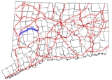
Route 109 is a state highway
in western Connecticut
, running from New Milford
to Thomaston
.
in New Milford and heads northeast into Washington
, where if overlaps Route 47
for 0.28 mile (0.4506152 km) before continuing into Morris
. In Morris, Route 109 heads east, then northeast and southeast, before cutting across a corner of Litchfield
by the Wigwam Reservoir into Thomaston. In Thomaston, Route 109 continues southeast and then east along the Wigwam Reservoir and Branch River to end at an intersection with US 6
and Route 254
.
and Route 109 was rerouted to its current western terminus using former SR 857. In 1968, the section near the Branch River in Thomaston was rerouted uphill to accommodate a flood control project.
State highway
State highway, state road or state route can refer to one of three related concepts, two of them related to a state or provincial government in a country that is divided into states or provinces :#A...
in western Connecticut
Connecticut
Connecticut is a state in the New England region of the northeastern United States. It is bordered by Rhode Island to the east, Massachusetts to the north, and the state of New York to the west and the south .Connecticut is named for the Connecticut River, the major U.S. river that approximately...
, running from New Milford
New Milford, Connecticut
New Milford is a town in southern Litchfield County, Connecticut, United States north of Danbury, on the Housatonic River. It is the largest town in the state in terms of land area at nearly . The population was 28,671 according to the Census Bureau's 2006 estimates...
to Thomaston
Thomaston, Connecticut
Thomaston is a town in Litchfield County, Connecticut, United States. The population was 7,503 at the 2000 census.-History:The town, originally part of Plymouth, Connecticut, and referred to as 'Plymouth Hollow' was first settled in the early 18th century. The town is known for clock making, which...
.
Route description
Route 109 begins at an intersection with US 202U.S. Route 202
U.S. Route 202 is a highway stretching from Delaware to Maine, also passing through the states of Pennsylvania, New Jersey, New York, Connecticut, Massachusetts, and New Hampshire....
in New Milford and heads northeast into Washington
Washington, Connecticut
Washington is a rural town in Litchfield County, Connecticut, in the New England region of the United States. The population was 3,596 at the 2000 census. Washington is known for its picturesque countryside, historic architecture, and active civic and cultural life...
, where if overlaps Route 47
Connecticut Route 47
Route 47 is a Connecticut state highway from US 6 in Woodbury to US 202 in Washington, in the west-central part of the state. It is long and runs roughly northwest-southeast, signed north–south.- Route description:...
for 0.28 mile (0.4506152 km) before continuing into Morris
Morris, Connecticut
Morris is a town in Litchfield County, Connecticut, United States. The population was 2,301 at the 2000 census. The town consists of rolling hill country surrounding Bantam Lake, the largest natural lake in the State, covering about .-History:...
. In Morris, Route 109 heads east, then northeast and southeast, before cutting across a corner of Litchfield
Litchfield, Connecticut
Litchfield is a town in and former county seat of Litchfield County, Connecticut, United States, and is known as an affluent summer resort. The population was 8,316 at the 2000 census. The boroughs of Bantam and Litchfield are located within the town...
by the Wigwam Reservoir into Thomaston. In Thomaston, Route 109 continues southeast and then east along the Wigwam Reservoir and Branch River to end at an intersection with US 6
U.S. Route 6
U.S. Route 6 , also called the Grand Army of the Republic Highway, a name that honors an American Civil War veterans association, is a main route of the U.S. Highway system, running east-northeast from Bishop, California to Provincetown, Massachusetts. Until 1964, it continued south from Bishop to...
and Route 254
Connecticut Route 254
Route 254 is a state highway in northwestern Connecticut running from Thomaston to Litchfield.-Route description:Route 254 begins as a continuation of State Road 848 at a northbound exit from Route 8 in southeastern Thomaston. It heads north, crosses under the Route 8 expressway, and meets U.S...
.
History
In 1922, the Bantam to Morris route was designated as State Highway 310. This became part of Route 109 when it was commissioned in 1932, running from the Bantam section of Litchfield past Bantam Lake to its current eastern terminus in Thomaston. In 1963, the section past Bantam Lake was reassigned to Route 209Connecticut Route 209
Route 209 is a rural state highway in northwestern Connecticut, running from the town center of Morris to the borough of Bantam in the town of Litchfield.-Route description:...
and Route 109 was rerouted to its current western terminus using former SR 857. In 1968, the section near the Branch River in Thomaston was rerouted uphill to accommodate a flood control project.
Junction list
| Town | Road names | Junction | Milepost |
|---|---|---|---|
| New Milford New Milford, Connecticut New Milford is a town in southern Litchfield County, Connecticut, United States north of Danbury, on the Housatonic River. It is the largest town in the state in terms of land area at nearly . The population was 28,671 according to the Census Bureau's 2006 estimates... (3.52 miles) |
Chestnut Land Rd. | 0.00 | |
| Washington Washington, Connecticut Washington is a rural town in Litchfield County, Connecticut, in the New England region of the United States. The population was 3,596 at the 2000 census. Washington is known for its picturesque countryside, historic architecture, and active civic and cultural life... (6.94 miles) |
Church Hill Rd., Calhoun St., Blackville Rd., Old Litchfield Rd. |
(Begin Multiplex) | 6.10 |
| (End Multiplex) | 6.38 | ||
| Morris Morris, Connecticut Morris is a town in Litchfield County, Connecticut, United States. The population was 2,301 at the 2000 census. The town consists of rolling hill country surrounding Bantam Lake, the largest natural lake in the State, covering about .-History:... (7.26 miles) |
Washington Rd., Lakeside Rd., West St., East St., Thomaston Rd. |
12.45 | |
| 14.06 | |||
| 15.20 | |||
| Litchfield Litchfield, Connecticut Litchfield is a town in and former county seat of Litchfield County, Connecticut, United States, and is known as an affluent summer resort. The population was 8,316 at the 2000 census. The boroughs of Bantam and Litchfield are located within the town... (0.07 miles) |
Route 109 | (No Major Junctions) | |
| Thomaston Thomaston, Connecticut Thomaston is a town in Litchfield County, Connecticut, United States. The population was 7,503 at the 2000 census.-History:The town, originally part of Plymouth, Connecticut, and referred to as 'Plymouth Hollow' was first settled in the early 18th century. The town is known for clock making, which... (3.14 miles) |
Branch Road | 20.93 |