
Coleambally, New South Wales
Encyclopedia
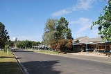
Coleambally is a small town in the Riverina
of New South Wales
, Australia
, in Murrumbidgee Shire.
Coleambally is one of the newest towns in the state of New South Wales
, officially opened in June 1968, with the Post Office opening on 1 April 1970.
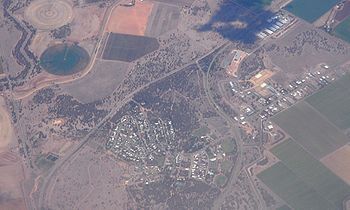
Designed to act as the centre for the surrounding Coleambally Irrigation Area, at the 2006 census
, Coleambally had a population of 658 people.
Its name is Aboriginal, probably meaning a swift
in flight. The spine-tailed swift is one of the most powerful fliers known, wheeling and sweeping at high speed in search of flying insects.
Coleambally can be accessed by road from Sydney
and Canberra
via the Hume Highway
and Burley Griffin Way
and from Melbourne
via the Hume Highway
, Newell Highway
and the Kidman Way
.
In 2008, following the Federal Government's proposals to buy large amounts of water from irrigators — ostensibly to "save" the Murray-Darling Basin
— the Coleambally Irrigation Area offered the entire area, including the farms, water rights and the entire town, for sale at a price of $3.5 billion.
and soya beans. Grazing of sheep and cattle is also common.
The quality of soil in the Coleambally Irrigation Area, combined with growing a water-intensive crop such as rice, has led to soil salination
and high water table
problems throughout the area. Efforts to alleviate the soil salination problem since 1995 have minimised the problem.
The lack of water during the latest drought
has put the rice industry at risk, with severe water restrictions being imposed. Competition from highly subsidised US
farmers also poses a large threat to this industry and the families involved in it.
Rice production in 2006 will be much higher than recent years due to greater water allocations being available.
Total rice production in 2006 in the Murray
Valley and the Murrumbidgee Irrigation Area
(MIA) and Coleambally Irrigation Area are expected to total 1000000 tonnes (1,102,311.3 ST), up from 330000 tonnes (363,762.7 ST) in 2005.
The Roman Catholic Church is dedicated to St Peter.
The church of the Uniting Church of Australia was formerly a shearer's quarters before being moved to its present location.

.
Riverina
The Riverina is an agricultural region of south-western New South Wales , Australia. The Riverina is distinguished from other Australian regions by the combination of flat plains, warm to hot climate and an ample supply of water for irrigation. This combination has allowed the Riverina to develop...
of New South Wales
New South Wales
New South Wales is a state of :Australia, located in the east of the country. It is bordered by Queensland, Victoria and South Australia to the north, south and west respectively. To the east, the state is bordered by the Tasman Sea, which forms part of the Pacific Ocean. New South Wales...
, Australia
Australia
Australia , officially the Commonwealth of Australia, is a country in the Southern Hemisphere comprising the mainland of the Australian continent, the island of Tasmania, and numerous smaller islands in the Indian and Pacific Oceans. It is the world's sixth-largest country by total area...
, in Murrumbidgee Shire.
Coleambally is one of the newest towns in the state of New South Wales
New South Wales
New South Wales is a state of :Australia, located in the east of the country. It is bordered by Queensland, Victoria and South Australia to the north, south and west respectively. To the east, the state is bordered by the Tasman Sea, which forms part of the Pacific Ocean. New South Wales...
, officially opened in June 1968, with the Post Office opening on 1 April 1970.
Designed to act as the centre for the surrounding Coleambally Irrigation Area, at the 2006 census
Census in Australia
The Australian census is administered once every five years by the Australian Bureau of Statistics. The most recent census was conducted on 9 August 2011; the next will be conducted in 2016. Prior to the introduction of regular censuses in 1961, they had also been run in 1901, 1911, 1921, 1933,...
, Coleambally had a population of 658 people.
Its name is Aboriginal, probably meaning a swift
Swift
The swifts are a family, Apodidae, of highly aerial birds. They are superficially similar to swallows, but are actually not closely related to passerine species at all; swifts are in the separate order Apodiformes, which they share with hummingbirds...
in flight. The spine-tailed swift is one of the most powerful fliers known, wheeling and sweeping at high speed in search of flying insects.
Coleambally can be accessed by road from Sydney
Sydney
Sydney is the most populous city in Australia and the state capital of New South Wales. Sydney is located on Australia's south-east coast of the Tasman Sea. As of June 2010, the greater metropolitan area had an approximate population of 4.6 million people...
and Canberra
Canberra
Canberra is the capital city of Australia. With a population of over 345,000, it is Australia's largest inland city and the eighth-largest city overall. The city is located at the northern end of the Australian Capital Territory , south-west of Sydney, and north-east of Melbourne...
via the Hume Highway
Hume Highway
The Hume Highway/Hume Freeway is one of Australia's major inter-city highways, running for 880 km between Sydney and Melbourne. It is part of the Auslink National Network and is a vital link for road freight to transport goods to and from the two cities as well as serving Albury-Wodonga and...
and Burley Griffin Way
Burley Griffin Way
Burley Griffin Way is a New South Wales state route, is located in south eastern Australia. Named after the American architect, Walter Burley Griffin, designer of the cities of Canberra and Griffith, the highway links the two cities via Yass and the Barton Highway.It provides a major link between...
and from Melbourne
Melbourne
Melbourne is the capital and most populous city in the state of Victoria, and the second most populous city in Australia. The Melbourne City Centre is the hub of the greater metropolitan area and the Census statistical division—of which "Melbourne" is the common name. As of June 2009, the greater...
via the Hume Highway
Hume Highway
The Hume Highway/Hume Freeway is one of Australia's major inter-city highways, running for 880 km between Sydney and Melbourne. It is part of the Auslink National Network and is a vital link for road freight to transport goods to and from the two cities as well as serving Albury-Wodonga and...
, Newell Highway
Newell Highway
The Newell Highway is the longest highway in New South Wales, Australia. It runs parallel to the eastern coast about 400 kilometres inland, and is the main inland direct road link from Victoria to Queensland, bypassing the more congested coastal areas of New South Wales...
and the Kidman Way
Kidman Way
The Kidman Way is an important highway in New South Wales , Australia, which is designated as State Highway 87. It is named after Sir Sidney Kidman, Australian cattle king and philanthropist who owned a large number of cattle stations along the path, many still owned by his descendants. It is an...
.
History
The Coleambally Irrigation Area scheme was started in the 1950s, with potential farmland being made available through a ballot system. Those who entered the ballot had to prove they had enough money to set up a farm in order to enter, as the land they acquired started off with no fencing or infrastructure whatsoever. The successful ballot winners were also required to give up any other primary interests they may have held. They were to give all or nothing to Coleambally.In 2008, following the Federal Government's proposals to buy large amounts of water from irrigators — ostensibly to "save" the Murray-Darling Basin
Murray-Darling Basin
The Murray-Darling basin is a large geographical area in the interior of southeastern Australia, whose name is derived from its two major rivers, the Murray River and the Darling River. It drains one-seventh of the Australian land mass, and is currently by far the most significant agricultural...
— the Coleambally Irrigation Area offered the entire area, including the farms, water rights and the entire town, for sale at a price of $3.5 billion.
Commerce
Its main industry has been rice growing, with a major rice mill located one kilometre north of the town. Other crops are also grown, such as wheat, maize, sorghumSorghum
Sorghum is a genus of numerous species of grasses, one of which is raised for grain and many of which are used as fodder plants either cultivated or as part of pasture. The plants are cultivated in warmer climates worldwide. Species are native to tropical and subtropical regions of all continents...
and soya beans. Grazing of sheep and cattle is also common.
The quality of soil in the Coleambally Irrigation Area, combined with growing a water-intensive crop such as rice, has led to soil salination
Soil salination
Soil salinity is the salt content in the soil.- Causes of soil salinity :Salt-affected soils are caused by excess accumulation of salts, typically most pronounced at the soil surface. Salts can be transported to the soil surface by capillary transport from a salt laden water table and then...
and high water table
Water table
The water table is the level at which the submarine pressure is far from atmospheric pressure. It may be conveniently visualized as the 'surface' of the subsurface materials that are saturated with groundwater in a given vicinity. However, saturated conditions may extend above the water table as...
problems throughout the area. Efforts to alleviate the soil salination problem since 1995 have minimised the problem.
The lack of water during the latest drought
Drought
A drought is an extended period of months or years when a region notes a deficiency in its water supply. Generally, this occurs when a region receives consistently below average precipitation. It can have a substantial impact on the ecosystem and agriculture of the affected region...
has put the rice industry at risk, with severe water restrictions being imposed. Competition from highly subsidised US
United States
The United States of America is a federal constitutional republic comprising fifty states and a federal district...
farmers also poses a large threat to this industry and the families involved in it.
Rice production in 2006 will be much higher than recent years due to greater water allocations being available.
Total rice production in 2006 in the Murray
Murray River
The Murray River is Australia's longest river. At in length, the Murray rises in the Australian Alps, draining the western side of Australia's highest mountains and, for most of its length, meanders across Australia's inland plains, forming the border between New South Wales and Victoria as it...
Valley and the Murrumbidgee Irrigation Area
Murrumbidgee Irrigation Area
The Murrumbidgee Irrigation Area is geographically located within the Riverina area of New South Wales was created to control and divert the flow of local river and creek systems for the purpose of food production...
(MIA) and Coleambally Irrigation Area are expected to total 1000000 tonnes (1,102,311.3 ST), up from 330000 tonnes (363,762.7 ST) in 2005.
Education
There are two schools in Coleambally: Coleambally Central School, a comprehensive government school catering for students from Kindergarten to Year 12, and St Peter's Primary School, a Roman Catholic school administered by the Diocese of Wagga Wagga.Churches
Coleambally is situated in the Anglican Diocese of Riverina. The Anglican Church is dedicated to St Mark.The Roman Catholic Church is dedicated to St Peter.
The church of the Uniting Church of Australia was formerly a shearer's quarters before being moved to its present location.
Attractions
Coleambally's distinctive wine glass shaped water tower is located in the centre of town. A Bucyrus Class Dragline is located in the Lions Park at the entrance of the town. It is one of four machines imported from the United States in 1935 to excavate the main irrigation channels in the Murray Valley and the Coleambally Irrigation Area in the early 1960s.Popular culture
Coleambally was mentioned in the television miniseries Underbelly: A Tale of Two CitiesUnderbelly: A Tale of Two Cities
Underbelly: A Tale of Two Cities is a 13-part Australian television mini-series loosely based on real events that stemmed from the marijuana trade centred around the New South Wales town of Griffith. The timeline of the series is the years between 1976 and 1987. Underbelly: A Tale of Two Cities...
.