

Colca Canyon
Encyclopedia
Colca Canyon is a canyon
of the Colca River
in southern Peru
. Peru's third most-visited tourist destination with about 160,000 visitors annually, it's located about 100 miles (160 kilometers) northwest of Arequipa
. It is more than twice as deep as the Grand Canyon
in the United States
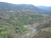
at 13,650' (4,160 m.) depth, and it is promoted as the "world's deepest canyon," although the canyon's walls are not as vertical as those of the Grand Canyon. The Colca Valley is a colorful Andean valley with pre-Inca roots, and towns founded in Spanish colonial times, still inhabited by people of the Collagua and the Cabana
cultures. The local people maintain their ancestral traditions and continue to cultivate the pre-Inca stepped terraces.

 The Colca River starts high in the Andes
at Condorama Crucero Alto; below the Colca canyon, as it crosses the plains of Majes it is known as the Majes River, and then is known as the Camana before reaching the Pacific Ocean
at the town of that name. Within the Province of Caylloma, it is known as the "Colca Valley" between Callalli at the upper end, and Pinchollo/Madrigal at the lower; below that, down to Huambo, it is considered to be the "Colca Canyon." All of the valley, and parts of the canyon are habitable, and Inca and pre-Inca terraces are still cultivated along the less precipitous canyon walls. The town of Chivay
(pop. 6,532, INEI 2007) is located at the midpoint of the Colca valley. Above Chivay, at an elevation of 12,000' (3,650 m.), agriculture gives way to livestock raising, principally alpacas and llamas, with some sheep and dairy cattle as well; below Chivay, the valley presents one of the most intensely-terraced landscapes in the world, continuing for many kilometers downstream. Within the deepening valley downriver, a series of small villages is spread out over the approximately 35 miles (56 km) between Chivay and the village of Cabanaconde. The canyon reaches its greatest depth in the region of Huambo, where the river has an elevation of 3,497-ft (1,066-m); in contrast, about 15 miles (24 km) to the southeast of Cabanaconde rises the 20,630-ft (6,288-m) Nevado Ampato, a snow-capped extinct volcano.
The valley lies between the Callalli and Huambo districts of the Caylloma Province
.
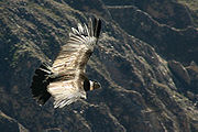 The canyon is home to the Andean Condor
(Vultur gryphus), a species that has seen worldwide effort to preserve it. The condors can be seen at close range as they fly past the canyon walls, and are the region's most popular attraction. 'Cruz del Condor' is a popular tourist stop to view the condors, an overlook where condors soar gracefully on thermals of warm air rising from the canyon. The condors are best seen in the early morning and late afternoon when they are hunting. At this point the canyon floor is 3,960 feet (1,200 m) below the rim of the canyon.
Other notable bird species present in the Colca include the Giant Colibri, the largest member of the hummingbird family; the Andean Goose; Chilean Flamingo; and Mountain Caracara. Animals include the vizcacha, a rabbit-sized relative of the chinchilla; zorrino, a member of the skunk family; deer; fox; and vicuna, the wild ancestor of the alpaca.
The La Calera natural hot springs are located at Chivay, the biggest town in the Colca Canyon. Other hot springs, some developed for tourist use, are dotted throughout the valley and canyon.
Archeological sites include: the caves of Mollepunko, above Callalli, where rock art (said to be 6,000 years old) depicts the domestication of the alpaca; the mummy of Paraqra, above Sibayo; the Fortaleza de Chimpa, a reconstructed mountaintop citadel that looks down on Madrigal; ruins of pre-Hispanic settlements throughout the valley; and many others.
Activities include hiking, mountain biking, trekking, mountaineering, rafting, horseback riding, fishing, and sightseeing.
Cultural attractions: festivals throughout the year, including the Wititi festival in Chivay, December 8–11; the Wititi has been declared the dance most representative of the Arequipa region, and named as a "cultural heritage" of Peru. The Colca is also well-known for two forms of crafts: goods knitted from 100% baby alpaca fiber (hats, gloves, etc.), and a unique form of embroidery that adorns skirts (polleras), hats, vests, and other items of daily wear and use.
Other attractions: the most distant source of the Amazon River is accessible from the Colca valley via Tuti, a one-day trip to a spring at 16,800 feet (5,120 m), where snowmelt from Nevado Mismi
bursts from a rock face; the Infiernillo geyser, on the flanks of Nevado Huallca Huallca, accessible on foot, horseback, or mountain bicycle; and a number of "casas vivenciales," where tourists can stay with a local family in their home, and share in their daily activities.
Autocolca, an autonomous authority created by law in the 1980s, is responsible for tourism promotion and management in the Colca valley. A "tourist ticket" is required for entry to the touristic zone of the Colca; the tourist ticket is currently valued at 35 Nuevos Soles (roughly $12.50) for foreign visitors, half that for Peruvian nationals, to enter the Colca tourist zone.
No passable roads existed between Arequipa and Chivay until the 1940s, when a road was completed to serve the silver and copper mines of the region. In the 1970s and 1980s, the Majes Hydroelectric Project — which diverted water from the Colca River to irrigate crops in the Majes region — built roads within the valley, and opened the area to outsiders. Access today is usually via Arequipa
.
In May 1981, the Polish "Canoandes" rafting expedition made the first descent of the river below Cabanaconde, and proclaimed the possibility of its being the world's deepest canyon. It was so recognized by the Guinness Book of Records in 1986, and a National Geographic article in January 1993 repeated the claim. The joint Polish/Peruvian "Cañon del Colca 2005" expedition verified the altitudes of the river and the surrounding heights via GPS in 2005.
Tourism has exploded since the publicity of the 1980s and 1990s, increasing from a few thousand visitors annually, to nearly 150,000 visitors in 2010.
Canyon
A canyon or gorge is a deep ravine between cliffs often carved from the landscape by a river. Rivers have a natural tendency to reach a baseline elevation, which is the same elevation as the body of water it will eventually drain into. This forms a canyon. Most canyons were formed by a process of...
of the Colca River
Colca River
The Colca River is a Peruvian river that flows deep in the rugged Andes of southern Peru....
in southern Peru
Peru
Peru , officially the Republic of Peru , is a country in western South America. It is bordered on the north by Ecuador and Colombia, on the east by Brazil, on the southeast by Bolivia, on the south by Chile, and on the west by the Pacific Ocean....
. Peru's third most-visited tourist destination with about 160,000 visitors annually, it's located about 100 miles (160 kilometers) northwest of Arequipa
Arequipa
Arequipa is the capital city of the Arequipa Region in southern Peru. With a population of 836,859 it is the second most populous city of the country...
. It is more than twice as deep as the Grand Canyon
Grand Canyon
The Grand Canyon is a steep-sided canyon carved by the Colorado River in the United States in the state of Arizona. It is largely contained within the Grand Canyon National Park, the 15th national park in the United States...
in the United States
United States
The United States of America is a federal constitutional republic comprising fifty states and a federal district...
at 13,650' (4,160 m.) depth, and it is promoted as the "world's deepest canyon," although the canyon's walls are not as vertical as those of the Grand Canyon. The Colca Valley is a colorful Andean valley with pre-Inca roots, and towns founded in Spanish colonial times, still inhabited by people of the Collagua and the Cabana
Cabana
A cabana or cabaña may mean:Structures:*a small hut built with a thatched roof, most commonly built in tropical climates near bodies of water, or...
cultures. The local people maintain their ancestral traditions and continue to cultivate the pre-Inca stepped terraces.
Geography
Andes
The Andes is the world's longest continental mountain range. It is a continual range of highlands along the western coast of South America. This range is about long, about to wide , and of an average height of about .Along its length, the Andes is split into several ranges, which are separated...
at Condorama Crucero Alto; below the Colca canyon, as it crosses the plains of Majes it is known as the Majes River, and then is known as the Camana before reaching the Pacific Ocean
Pacific Ocean
The Pacific Ocean is the largest of the Earth's oceanic divisions. It extends from the Arctic in the north to the Southern Ocean in the south, bounded by Asia and Australia in the west, and the Americas in the east.At 165.2 million square kilometres in area, this largest division of the World...
at the town of that name. Within the Province of Caylloma, it is known as the "Colca Valley" between Callalli at the upper end, and Pinchollo/Madrigal at the lower; below that, down to Huambo, it is considered to be the "Colca Canyon." All of the valley, and parts of the canyon are habitable, and Inca and pre-Inca terraces are still cultivated along the less precipitous canyon walls. The town of Chivay
Chivay
Chivay is a town in the Colca valley, capital of the Caylloma province in the Arequipa region, Peru. Located at about 12,000 ft above sea level, it lies upstream of the renowned Colca Canyon. It has a central town square and an active market...
(pop. 6,532, INEI 2007) is located at the midpoint of the Colca valley. Above Chivay, at an elevation of 12,000' (3,650 m.), agriculture gives way to livestock raising, principally alpacas and llamas, with some sheep and dairy cattle as well; below Chivay, the valley presents one of the most intensely-terraced landscapes in the world, continuing for many kilometers downstream. Within the deepening valley downriver, a series of small villages is spread out over the approximately 35 miles (56 km) between Chivay and the village of Cabanaconde. The canyon reaches its greatest depth in the region of Huambo, where the river has an elevation of 3,497-ft (1,066-m); in contrast, about 15 miles (24 km) to the southeast of Cabanaconde rises the 20,630-ft (6,288-m) Nevado Ampato, a snow-capped extinct volcano.
The valley lies between the Callalli and Huambo districts of the Caylloma Province
Caylloma Province
Caylloma Province is the largest of eight provinces in the Arequipa Region of Peru.-Points of interest:The Colca Canyon lies in the Huambo and Callalli districts.-Political division:The province is divided into twenty districts which are:...
.
Attractions
Andean Condor
The Andean Condor is a species of South American bird in the New World vulture family Cathartidae and is the only member of the genus Vultur...
(Vultur gryphus), a species that has seen worldwide effort to preserve it. The condors can be seen at close range as they fly past the canyon walls, and are the region's most popular attraction. 'Cruz del Condor' is a popular tourist stop to view the condors, an overlook where condors soar gracefully on thermals of warm air rising from the canyon. The condors are best seen in the early morning and late afternoon when they are hunting. At this point the canyon floor is 3,960 feet (1,200 m) below the rim of the canyon.
Other notable bird species present in the Colca include the Giant Colibri, the largest member of the hummingbird family; the Andean Goose; Chilean Flamingo; and Mountain Caracara. Animals include the vizcacha, a rabbit-sized relative of the chinchilla; zorrino, a member of the skunk family; deer; fox; and vicuna, the wild ancestor of the alpaca.
The La Calera natural hot springs are located at Chivay, the biggest town in the Colca Canyon. Other hot springs, some developed for tourist use, are dotted throughout the valley and canyon.
Archeological sites include: the caves of Mollepunko, above Callalli, where rock art (said to be 6,000 years old) depicts the domestication of the alpaca; the mummy of Paraqra, above Sibayo; the Fortaleza de Chimpa, a reconstructed mountaintop citadel that looks down on Madrigal; ruins of pre-Hispanic settlements throughout the valley; and many others.
Activities include hiking, mountain biking, trekking, mountaineering, rafting, horseback riding, fishing, and sightseeing.
Cultural attractions: festivals throughout the year, including the Wititi festival in Chivay, December 8–11; the Wititi has been declared the dance most representative of the Arequipa region, and named as a "cultural heritage" of Peru. The Colca is also well-known for two forms of crafts: goods knitted from 100% baby alpaca fiber (hats, gloves, etc.), and a unique form of embroidery that adorns skirts (polleras), hats, vests, and other items of daily wear and use.
Other attractions: the most distant source of the Amazon River is accessible from the Colca valley via Tuti, a one-day trip to a spring at 16,800 feet (5,120 m), where snowmelt from Nevado Mismi
Nevado Mismi
Nevado Mismi is a mountain peak of volcanic origin located in the Andes mountain range of Peru. A glacial stream on the Mismi was firmly identified as the most distant source of the Amazon River in 1996; this finding was confirmed in 2001 and again in 2007....
bursts from a rock face; the Infiernillo geyser, on the flanks of Nevado Huallca Huallca, accessible on foot, horseback, or mountain bicycle; and a number of "casas vivenciales," where tourists can stay with a local family in their home, and share in their daily activities.
Autocolca, an autonomous authority created by law in the 1980s, is responsible for tourism promotion and management in the Colca valley. A "tourist ticket" is required for entry to the touristic zone of the Colca; the tourist ticket is currently valued at 35 Nuevos Soles (roughly $12.50) for foreign visitors, half that for Peruvian nationals, to enter the Colca tourist zone.
Name
The name Colca refers to small granaries of mud and stone, built into the cliffs in the valley and canyon. These repositories were used in Inca and pre-Inca times to store food, such as potatoes, quinoa, and other Andean crops. They were also used as tombs for important people.History
The quechua-speaking Cabanas, probably descended from the Wari culture, and the Aymara-speaking Collaguas, who moved to the area from the Lake Titicaca region, inhabited the valley in the pre-Inca era. The Inca probably arrived in the Colca valley around 1320 AD, and established their dominion through marriage, rather than through warfare. The Spaniards, under Gonzalo Pizarro, arrived in 1540, and in the 1570s the Spanish viceroy Francisco de Toledo ordered the inhabitants to leave their scattered settlements and to move to a series of centrally-located pueblos, which remain the principal towns of the valley. Franciscan missionaries built the first chapel in the valley in 1565, and the first church in 1569 (Coporaque).No passable roads existed between Arequipa and Chivay until the 1940s, when a road was completed to serve the silver and copper mines of the region. In the 1970s and 1980s, the Majes Hydroelectric Project — which diverted water from the Colca River to irrigate crops in the Majes region — built roads within the valley, and opened the area to outsiders. Access today is usually via Arequipa
Arequipa
Arequipa is the capital city of the Arequipa Region in southern Peru. With a population of 836,859 it is the second most populous city of the country...
.
In May 1981, the Polish "Canoandes" rafting expedition made the first descent of the river below Cabanaconde, and proclaimed the possibility of its being the world's deepest canyon. It was so recognized by the Guinness Book of Records in 1986, and a National Geographic article in January 1993 repeated the claim. The joint Polish/Peruvian "Cañon del Colca 2005" expedition verified the altitudes of the river and the surrounding heights via GPS in 2005.
Tourism has exploded since the publicity of the 1980s and 1990s, increasing from a few thousand visitors annually, to nearly 150,000 visitors in 2010.