

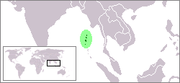
Coco Islands
Encyclopedia
Indian Ocean
The Indian Ocean is the third largest of the world's oceanic divisions, covering approximately 20% of the water on the Earth's surface. It is bounded on the north by the Indian Subcontinent and Arabian Peninsula ; on the west by eastern Africa; on the east by Indochina, the Sunda Islands, and...
, politically administered by Burma under Yangon Division
Yangon Division
Yangon Region is an administrative region of Myanmar. Located in the heart of Lower Myanmar, the division is bordered by Bago Region in the north and east, the Gulf of Martaban in the south, and Ayeyarwady Region in the west. Yangon Region is dominated by its capital city of Yangon, the former...
. They are allegedly leased to the People's Republic of China
People's Republic of China
China , officially the People's Republic of China , is the most populous country in the world, with over 1.3 billion citizens. Located in East Asia, the country covers approximately 9.6 million square kilometres...
since 1994. Both the government of Burma and the People's Republic of China do not comment on this issue, while many members of the Burmese military categorically deny any agreement at all.
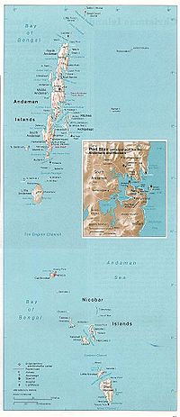
Geographically, they are a part of the Andaman Islands
Andaman Islands
The Andaman Islands are a group of Indian Ocean archipelagic islands in the Bay of Bengal between India to the west, and Burma , to the north and east...
archipelago and separated from the North Andaman Island
North Andaman Island
North Andaman Island is the northern island of Great Andaman of the Andaman Islands, with an area of 1376 km². The main town on the island is Diglipur. Known for its marine life, the island's main industries are rice and orange-growing...
(India
India
India , officially the Republic of India , is a country in South Asia. It is the seventh-largest country by geographical area, the second-most populous country with over 1.2 billion people, and the most populous democracy in the world...
) by the 20 kilometres (12.4 mi) wide Coco Channel. The Bay of Bengal
Bay of Bengal
The Bay of Bengal , the largest bay in the world, forms the northeastern part of the Indian Ocean. It resembles a triangle in shape, and is bordered mostly by the Eastern Coast of India, southern coast of Bangladesh and Sri Lanka to the west and Burma and the Andaman and Nicobar Islands to the...
lies to the west and the Andaman Sea
Andaman Sea
The Andaman Sea or Burma Sea is a body of water to the southeast of the Bay of Bengal, south of Burma, west of Thailand and east of the Andaman Islands, India; it is part of the Indian Ocean....
to the east of the islands. The Burmese mainland is 300 kilometres (186.4 mi) to the north.
The Coco Islands consist of the main Great Coco Island and the smaller Little Coco Island, separated by the Alexandra Channel. Table Island, a third small island located near the Great Coco Island, previously housed a lighthouse but is presently uninhabited.
History
Formerly Indian possessions, they were taken over by the East India CompanyEast India Company
The East India Company was an early English joint-stock company that was formed initially for pursuing trade with the East Indies, but that ended up trading mainly with the Indian subcontinent and China...
in the eighteenth century. They are located on an ancient trade route between India,
Burma and Southeast Asia, and there were numerous visits by traders, seafarers and pirates. In 1858, a large prison was built at Port Blair
Port Blair
Port Blair is the largest town and a municipal council in Andaman district in the Andaman Islands and the capital of the Andaman and Nicobar Islands, a union territory of India...
on South Andaman Island
South Andaman Island
South Andaman Island is the southernmost island of the Great Andaman and is home to the majority of the population of the Andaman Islands. Port Blair, the capital of the islands, is located on the southern part of this island. Some areas of the island are restricted areas for non-Indians; however,...
, mainly to house the thousands of ‘mutineers’ sent there after the 1857 Indian rebellion, and the Coco Islands were used as a source of food for the struggling penal colony, mainly by providing
coconuts. The lack of close supervision caused by the islands isolation prompted the colonial authorities in Calcutta to transfer jurisdiction of the 3 main islands and three small satellite islands to Rangoon, which by then was Britain’s administrative capital in Lower Burma. In 1882 the Coco Islands officially became part of British Burma. When Burma separated from India in 1937 and became a self-governing Crown Colony
Crown colony
A Crown colony, also known in the 17th century as royal colony, was a type of colonial administration of the English and later British Empire....
, the Coco Islands remained Burmese territory. In 1942, along with the rest of the Andaman and Nicobar chain, they were invaded by the Japanese. After Burma regained its independence from Britain in 1948, the
Islands passed to the new Union of Burma.
A statement by Indian Defence Minister George Fernandes to the BBC in 2003,
that Prime Minister Jawaharlal Nehru had ‘donated’ the Coco Islands to Burma
in the 1950s, and thus surrendered a vital strategic asset, was incorrect.
A penal colony was established on Great Coco Island in 1959 by General Ne Win’s interim military administration. After Ne Win’s coup d’etat in 1962, and the installation of a military
government, the prison gained the reputation of being a Burmese ‘Devil’s
Island’. In 1969, it was enlarged to cater to an increased number of political
prisoners. After a strike, all prisoners on the island were transferred to Rangoon’s Insein Jail in 1971. After the closing of the penal colony the facilities on Great Cocos Island were transferred to the Burmese Navy.http://www6.cityu.edu.hk/searc/Data/FileUpload/294/WP101_08_ASelth.pdf
Talks of Chinese Signal Gathering Station and Maritime Army Base
ChinaPeople's Republic of China
China , officially the People's Republic of China , is the most populous country in the world, with over 1.3 billion citizens. Located in East Asia, the country covers approximately 9.6 million square kilometres...
supposedly established a SIGINT
SIGINT
Signals intelligence is intelligence-gathering by interception of signals, whether between people , whether involving electronic signals not directly used in communication , or combinations of the two...
intelligence gathering station on Great Coco Island in 1992 to monitor Indian naval activity
Indian Navy
The Indian Navy is the naval branch of the armed forces of India. The President of India serves as the Commander-in-Chief of the Navy. The Chief of Naval Staff , usually a four-star officer in the rank of Admiral, commands the Navy...
in the Andaman and Nicobar Islands. The station is also said to allow China to monitor the movement of other navies and ships throughout the eastern Indian Ocean, especially in the crucial point in shipping routes between the Bay of Bengal and the Strait of Malacca
Strait of Malacca
The Strait of Malacca is a narrow, stretch of water between the Malay Peninsula and the Indonesian island of Sumatra. It is named after the Malacca Sultanate that ruled over the archipelago between 1414 to 1511.-Extent:...
. It may also be used to monitor activities at the launch site of the Indian Space Research Organization at Sriharikota
Sriharikota
Sriharikota is a barrier island off the coast of the southern state of Andhra Pradesh in India. It houses India's only satellite launch centre in the Satish Dhawan Space Centre and is used by the Indian Space Research Organisation to launch satellites using multi-stage rockets such as the Polar...
and the Defence Research and Development Organization at Chandipur-on-sea. The Chinese Army
People's Liberation Army
The People's Liberation Army is the unified military organization of all land, sea, strategic missile and air forces of the People's Republic of China. The PLA was established on August 1, 1927 — celebrated annually as "PLA Day" — as the military arm of the Communist Party of China...
is also building a maritime base on Little Coco Island.
Existence of the Chinese base has been questioned. India’s chief of naval staff is quoted as saying in October 2005 that India had “firm information that there is no listening post, radar or surveillance station belonging to the Chinese on Coco Islands.” In 1998 the U.S. stated that it had not detected any significant Chinese activity in Burma. Now, again there are news that China has started its operations again in the same region, and has put up a Listening Post.
On Great Coco Island, commercially available satellite imagery of the period 2006-2008 shows an airfield where the old coconut plantation used to be. There is also a small radar dish, a radio aerial, a jetty and a number of buildings, none of which can be considered unusual. There are no signs of a large base with accommodation for hundreds of servicemen, let alone the radomes, aerial farms and other such installations that characterise major electronic intelligence stations. There are a few buildings on Little Coco Island, and the old lighthouse and its ancillary buildings remain on Table Island, but neither of these islands shows any signs of military activity.
Great Coco Island
Great Coco Island (14°07′00"N 93°22′03"E) is approximately 10 km (6.2 mi) long and 2 km (1.2 mi) wide.Many green turtles nest on the beaches of the Great Coco Island. A series of research programs on marine turtle conservation have been conducted by Burma's Department of Fisheries. Data collection on tissue samples of green turtles for population genetic and tagging studies was conducted at Great Coco Island from March
March 2006
March 2006 is the third month of that year. It began on a Wednesday and 31 days later, ended on a Friday.-1 March 2006 :*Fijian Prime Minister Laisenia Qarase announces that the 2006 general elections will be held in the second week of May, from May 6 to May 13...
to April 2006. Prior to this, Great Coco Island had never been surveyed for marine turtle conservation by Department of Fisheries due to its remote location. The survey found an estimated 150 sea turtle
Sea turtle
Sea turtles are marine reptiles that inhabit all of the world's oceans except the Arctic.-Distribution:...
s nesting and between 90,000 and 100,000 hatchlings and juveniles.
Little Coco Island
Little Coco Island lies 15 km (9.3 mi) to the southwest from the Great Coco Island. It is approximately 5 km (3.1 mi) long and 1 km (0.621372736649807 mi) wide.Sources
- Indian Ocean - South-East Asian Marine Turtle Memorandum of Understanding
- Google Earth map of Chinese facilities at Great Coco Island
See also
- List of islands of Burma
- Foreign relations of Burma