
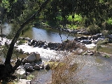
Cockburn River
Encyclopedia

New South Wales
New South Wales is a state of :Australia, located in the east of the country. It is bordered by Queensland, Victoria and South Australia to the north, south and west respectively. To the east, the state is bordered by the Tasman Sea, which forms part of the Pacific Ocean. New South Wales...
, Australia
Australia
Australia , officially the Commonwealth of Australia, is a country in the Southern Hemisphere comprising the mainland of the Australian continent, the island of Tasmania, and numerous smaller islands in the Indian and Pacific Oceans. It is the world's sixth-largest country by total area...
.
The Cockburn River rises near Woolbrook, New South Wales
Woolbrook, New South Wales
Woolbrook is a village in the New England region of New South Wales, Australia. The nearest town, Walcha is 29 km to the east of Woolbrook. At the 2006 census, Woolbrook had a population of 220....
in the southern New England
New England (Australia)
New England or New England North West is the name given to a generally undefined region about 60 kilometres inland, that includes the Northern Tablelands and the North West Slopes regions in the north of the state of New South Wales, Australia.-History:The region has been occupied by Indigenous...
tablelands. It drains the western side of the Great Dividing Range
Great Dividing Range
The Great Dividing Range, or the Eastern Highlands, is Australia's most substantial mountain range and the third longest in the world. The range stretches more than 3,500 km from Dauan Island off the northeastern tip of Queensland, running the entire length of the eastern coastline through...
. It flows generally to the south-west, eventually joining the Peel River
Peel River (New South Wales)
The Peel River is a river in New South Wales, Australia. It is part of the Murray-Darling Basin.The Peel rises on the northern slopes of the Liverpool Range south of the village of Nundle. It flows generally north and west through the foothills of the Great Dividing Range, through Woolomin and...
at Nemingha
Nemingha, New South Wales
Nemingha is an outer suburb of Tamworth, New South Wales, Australia, located 5 km south of the Tamworth Central Business District on the New England Highway. Northwest of Nemingha is East Tamworth and the Tamworth Central Business District.-References:...
, about three kilometres east of the city of Tamworth
Tamworth, New South Wales
Tamworth is a city in the New England region of New South Wales, Australia. Straddling the Peel River, Tamworth, which contains an estimated population of 47,595 people, is the major regional centre for southern New England and in the local government area of Tamworth Regional Council. The city...
.
Runoff from the southern side of the Moonbi Range
Moonbi Range
The Moonbi Range is a chain of hills which forms a part of the Northern Tablelands, New South Wales, Australia.The range is located roughly 20 kilometres north east of the city of Tamworth situated at the bottom of the Wentworth Mounds, which is part of the Moonbi Range. These mounds form a spur of...
mostly flows to the Cockburn River. There are small areas of irrigated cropping along the banks of the river and the surrounding hills are mostly used for grazing.
The river was first encountered by European explorers on 4 September 1818 during an expedition led by the Surveyor-General of New South Wales, John Oxley
John Oxley
John Joseph William Molesworth Oxley was an explorer and surveyor of Australia in the early period of English colonisation.October 1802 he was engaged in coastal survey work including an expedition to Western Port in 1804-05...
, who named the river after Admiral Sir George Cockburn
George Cockburn
Admiral of the Fleet Sir George Cockburn, 10th Baronet GCB was a British naval commander of the late 18th through the mid-19th centuries. He held important commands during the Napoleonic Wars and the War of 1812 and eventually rose to become Admiral of the Fleet and First Sea Lord.-Naval...
.
The localities of Kootingal
Kootingal, New South Wales
Kootingal is a town in New South Wales, Australia in the Tamworth Regional Council area. It is commonly called a satellite suburb of Tamworth because of its closeness and the fact that its residents use Tamworth's services. Founded as an Aboriginal mission, Kootingal traces its name roots to the...
, Tintinhull
Tintinhull, New South Wales
Tintinhull is a tiny hamlet about 10 kilometres east of Tamworth, New South Wales, Australia. It is situated between Nemingha and Kootingal, and lies on the New England Highway...
, Moonbi
Moonbi, New South Wales
Moonbi is a village situated on the New England Highway 20 kilometres north of Tamworth, New South Wales, Australia. It is nestled at the foot of the Moonbi Range and is part of the Tamworth Regional Council Local Government Area. Moonbi is located a few kilometres to the north of town of Kootingal...
and Limbri
Limbri, New South Wales
Limbri is a small village on Swamp Oak Creek, about 30 km east northeast of Tamworth and about 8 km east southeast of Moonbi in northern New South Wales, Australia. The population of the Limbri region in 2006 was 259.Some alluvial gold was found at Limbri...
are located near the Cockburn River.
A section of the Main North railway line
Main North railway line, New South Wales
The Main North Line is a major railway in New South Wales, Australia. It runs through the Central Coast, Hunter and the New England regions. The line was the original main line between Sydney and Brisbane, however this required a change of gauge at Wallangarra...
runs along the valley of the Cockburn River.
The Cockburn is also one of the fastest flowing rivers in the southern hemisphere. It is home to fish species such as Catfish,Yellow Belly and unfortunately Carp which have decimated the native fish stocks to the point that they are getting harder to find.