
Clowne
Encyclopedia
Clowne is a village and civil parish
in the Bolsover
district of Derbyshire
, England
. It forms part of the Bolsover constituency. Clowne lies 9 miles (14.5 km) north east of Chesterfield and 7 miles (11.3 km) south west of Worksop. It is mentioned in the Domesday Book
as Clune. The name is derived from the Celtic
Clun for a river.
of 1086. The two railway stations in the village spelt their names differently, one being called Clown, the other Clowne.
, on the southern end of the band of magnesian limestone
which runs south from Durham
to the Derbyshire
-Nottinghamshire
border, are Hollinhill and Markland Grips, a series of valleys often with vertical cliff-like sides formed by meltwater action of receding glacier
s at the end of the last Ice age
. 'Grips' is the local term for this feature. In the cliff sides are several small caves, rock shelters and fissures where human bones, which have been carbon dated
to the early Neolithic period
, have been discovered. During the Roman period
, a fort guarding an important ridgeway which ran north to south was close to Clowne. It was close to an even older Bronze Age
fortification on a promontory north of Hollinhill Grips. The Grips are a Site of Special Scientific Interest
, managed by the Derbyshire Wildlife Trust.
. The Domesday Book
refers to Ernui but then there was no mention of the manor until 1485 when Clowne was associated with the Bolsover
manor. The manor eventually passed to the Cavendish family and through marriage to the Bentinck family, the Dukes of Portland
.
The church, dedicated to St. John the Baptist
, was built during the 12th century. The medieval cross and the church of St. John the Baptist are the oldest surviving structures in the village.
In the 17th century Clowne was a rural farming community. Some buildings still stand from this date, notably the Anchor Inn and Sheridon's Yard (now private residences). The plague
struck Clowne in 1586 and 1606, and victims were buried away from the village at Monument Field or Plague Field.
During the Industrial Revolution
, Clowne grew exponentially, swallowing the tiny neighbouring villages of Hickinwood and Markland and becoming a colliery village. The sinking of the 1000 feet (304.8 m) deep mine, Southgate Colliery, in 1877 brought in workers from elsewhere. At its peak it employed 400 men and produced 600 tons of coal per day. At the end of the 19th century, rows of Victorian terraced houses were built to house the mining families. This growth left its mark on the village visible in the old school (built 1895), the terraced housing and the old village High Street (1901) as well as the Lancashire, Derbyshire and East Coast Railway
, which became the Great Central
, and the Midland Railway
lines which ran through the village each having a railway station. The colliery survived a fire in 1920 but closed in 1929 after the pit flooded.
times. Wapentake is a division of Danish or Viking origin. Clowne was part of the Worksop
Poor Law Union
which dates from July 1836. The workhouse was built in 1837 at East Gate in Worksop. Clowne, an old ecclesiastical parish
, was created Clowne Rural District
Council as part of the Worksop rural sanitary district
in 1894. This consisted of four civil parish
es; Barlborough
, Clowne, Elmton
, and Whitwell
, and was abolished in 1974 when it became part of Bolsover District Council
.
Clowne is part of the Bolsover parliamentary constituency which, at present, is held for the Labour Party
by Dennis Skinner
who has been their MP
since 1970.
and Worksop
. It is situated on the old Mansfield
to Rotherham
high road, now the A618, at its junction with the A616
road from Newark-on-Trent
to the M1 motorway
at nearby Barlborough. The village is surrounded by rolling farmland, mostly arable. The area of Clowne is 1825 acres (738.6 ha) of limestone and clay land watered by numerous springs. Harlesthorpe
Dam covers about 4 acres (1.6 ha) and there is a chalybeate
spring called Shuttlewood Spa in the neighbourhood. Land to the north west of Clowne is a Green belt
.
Of these, 19.84% worked in the wholesale and retail trade, including repair of motor vehicles; 17.77% worked within manufacturing industry; 12.10% worked within the health and social work sector and 8.86% were employed in the Education sector.
Regeneration of the town centre has taken place including the opening of a Tesco
supermarket, Wilkinson store and Aldi
supermarket. Clowne is now the largest town centre in the district in terms of retail floorspace.
Clowne is close to Creswell Crags
, the UK's only verified example of Paleolithic
cave art
, and close to the M1 motorway
. Historian James Romanelli recently auctioned off precious artefacts found near this site to an environmental institute.
operate services in and around Clowne.
, formerly Clowne Secondary School, on Boughton Lane was awarded specialist Mathematics and Computing School status in 2006. A new school is being built, which will be ready January 2011.
There was a mining college in Clowne and further education is provided by a newly built campus of the Chesterfield College
within the town.
, the south doorway and chancel arch are of Norman architecture
. It was partially rebuilt in the Early English and Perpendicular styles. The Norman chancel was rebuilt and enlarged in 1955 when two chapels were added, one dedicated to those who lost their lives in the coal mines.
Early recorded evidence shows the existence of a Primitive Methodist chapel in 1829, although the Ecclesiastical Census Return of 1851 dates the Primitive Methodist Chapel to 1834. A new building was opened in 1877.
The Salvation Army
meet in Clowne.
Roman Catholics in the area used Southgate House Chapel to celebrate mass. The chapel was built in 1901 by Lady Petre, the second wife of Colonel Butler Bowden. The chapel continued in use until 1950 and is now the dining room of the Van Dyk Hotel. Roman Catholics now worship at the Church of Sacred Heart in Clowne.
Civil parish
In England, a civil parish is a territorial designation and, where they are found, the lowest tier of local government below districts and counties...
in the Bolsover
Bolsover (district)
Bolsover is a local government district in Derbyshire, England. Its main town is Bolsover.There are fourteen town and parish councils within the district.In addition to the town councils of Old Bolsover and Shirebrook, there are the parish councils of:...
district of Derbyshire
Derbyshire
Derbyshire is a county in the East Midlands of England. A substantial portion of the Peak District National Park lies within Derbyshire. The northern part of Derbyshire overlaps with the Pennines, a famous chain of hills and mountains. The county contains within its boundary of approx...
, England
England
England is a country that is part of the United Kingdom. It shares land borders with Scotland to the north and Wales to the west; the Irish Sea is to the north west, the Celtic Sea to the south west, with the North Sea to the east and the English Channel to the south separating it from continental...
. It forms part of the Bolsover constituency. Clowne lies 9 miles (14.5 km) north east of Chesterfield and 7 miles (11.3 km) south west of Worksop. It is mentioned in the Domesday Book
Domesday Book
Domesday Book , now held at The National Archives, Kew, Richmond upon Thames in South West London, is the record of the great survey of much of England and parts of Wales completed in 1086...
as Clune. The name is derived from the Celtic
Celtic languages
The Celtic languages are descended from Proto-Celtic, or "Common Celtic"; a branch of the greater Indo-European language family...
Clun for a river.
Toponymy
Clowne, originally Clune, has been spelt in various ways over the last 1,000 years including, Cloune, Clone, Clowen, and most recently Clown. It was mentioned in the Domesday BookDomesday Book
Domesday Book , now held at The National Archives, Kew, Richmond upon Thames in South West London, is the record of the great survey of much of England and parts of Wales completed in 1086...
of 1086. The two railway stations in the village spelt their names differently, one being called Clown, the other Clowne.
Markland Grips
Between Clowne and CreswellCreswell, Derbyshire
Creswell is a village located in Bolsover, near Worksop, Derbyshire, England, United Kingdom. It is best known for Creswell Crags and Creswell Model Village....
, on the southern end of the band of magnesian limestone
Dolomite
Dolomite is a carbonate mineral composed of calcium magnesium carbonate CaMg2. The term is also used to describe the sedimentary carbonate rock dolostone....
which runs south from Durham
Durham
Durham is a city in north east England. It is within the County Durham local government district, and is the county town of the larger ceremonial county...
to the Derbyshire
Derbyshire
Derbyshire is a county in the East Midlands of England. A substantial portion of the Peak District National Park lies within Derbyshire. The northern part of Derbyshire overlaps with the Pennines, a famous chain of hills and mountains. The county contains within its boundary of approx...
-Nottinghamshire
Nottinghamshire
Nottinghamshire is a county in the East Midlands of England, bordering South Yorkshire to the north-west, Lincolnshire to the east, Leicestershire to the south, and Derbyshire to the west...
border, are Hollinhill and Markland Grips, a series of valleys often with vertical cliff-like sides formed by meltwater action of receding glacier
Glacier
A glacier is a large persistent body of ice that forms where the accumulation of snow exceeds its ablation over many years, often centuries. At least 0.1 km² in area and 50 m thick, but often much larger, a glacier slowly deforms and flows due to stresses induced by its weight...
s at the end of the last Ice age
Ice age
An ice age or, more precisely, glacial age, is a generic geological period of long-term reduction in the temperature of the Earth's surface and atmosphere, resulting in the presence or expansion of continental ice sheets, polar ice sheets and alpine glaciers...
. 'Grips' is the local term for this feature. In the cliff sides are several small caves, rock shelters and fissures where human bones, which have been carbon dated
Radiocarbon dating
Radiocarbon dating is a radiometric dating method that uses the naturally occurring radioisotope carbon-14 to estimate the age of carbon-bearing materials up to about 58,000 to 62,000 years. Raw, i.e. uncalibrated, radiocarbon ages are usually reported in radiocarbon years "Before Present" ,...
to the early Neolithic period
Neolithic
The Neolithic Age, Era, or Period, or New Stone Age, was a period in the development of human technology, beginning about 9500 BC in some parts of the Middle East, and later in other parts of the world. It is traditionally considered as the last part of the Stone Age...
, have been discovered. During the Roman period
Roman Britain
Roman Britain was the part of the island of Great Britain controlled by the Roman Empire from AD 43 until ca. AD 410.The Romans referred to the imperial province as Britannia, which eventually comprised all of the island of Great Britain south of the fluid frontier with Caledonia...
, a fort guarding an important ridgeway which ran north to south was close to Clowne. It was close to an even older Bronze Age
Bronze Age
The Bronze Age is a period characterized by the use of copper and its alloy bronze as the chief hard materials in the manufacture of some implements and weapons. Chronologically, it stands between the Stone Age and Iron Age...
fortification on a promontory north of Hollinhill Grips. The Grips are a Site of Special Scientific Interest
Site of Special Scientific Interest
A Site of Special Scientific Interest is a conservation designation denoting a protected area in the United Kingdom. SSSIs are the basic building block of site-based nature conservation legislation and most other legal nature/geological conservation designations in Great Britain are based upon...
, managed by the Derbyshire Wildlife Trust.
Early history
The first recorded mention of Clowne manor was in 1002 when the owner was Wulfric SpotWulfric Spot
Wulfric , called Wulfric Spot or Spott, was an Anglo-Saxon nobleman. His will is an important document from the reign of King Æthelred the Unready...
. The Domesday Book
Domesday Book
Domesday Book , now held at The National Archives, Kew, Richmond upon Thames in South West London, is the record of the great survey of much of England and parts of Wales completed in 1086...
refers to Ernui but then there was no mention of the manor until 1485 when Clowne was associated with the Bolsover
Bolsover
Bolsover is a town near Chesterfield, Derbyshire, England. It is 145 miles from London, 18 miles from Sheffield, 26 miles from Nottingham and 54 miles from Manchester. It is the main town in the Bolsover district.The civil parish for the town is called...
manor. The manor eventually passed to the Cavendish family and through marriage to the Bentinck family, the Dukes of Portland
Earl of Portland
Earl of Portland is a title that has been created twice in the Peerage of England, first in 1633 and again in 1689.-First creation :The title of Earl of Portland was first created for the politician Richard Weston, 1st Baron Weston, in 1633...
.
The church, dedicated to St. John the Baptist
John the Baptist
John the Baptist was an itinerant preacher and a major religious figure mentioned in the Canonical gospels. He is described in the Gospel of Luke as a relative of Jesus, who led a movement of baptism at the Jordan River...
, was built during the 12th century. The medieval cross and the church of St. John the Baptist are the oldest surviving structures in the village.
In the 17th century Clowne was a rural farming community. Some buildings still stand from this date, notably the Anchor Inn and Sheridon's Yard (now private residences). The plague
Bubonic plague
Plague is a deadly infectious disease that is caused by the enterobacteria Yersinia pestis, named after the French-Swiss bacteriologist Alexandre Yersin. Primarily carried by rodents and spread to humans via fleas, the disease is notorious throughout history, due to the unrivaled scale of death...
struck Clowne in 1586 and 1606, and victims were buried away from the village at Monument Field or Plague Field.
Industrial revolution
At the beginning of the 19th century the inhabitants of Clowne worked in agriculture, or mined the shallow coal seams. Others were employed at the mill, which made candle-wick, sacking and sail-cloth.During the Industrial Revolution
Industrial Revolution
The Industrial Revolution was a period from the 18th to the 19th century where major changes in agriculture, manufacturing, mining, transportation, and technology had a profound effect on the social, economic and cultural conditions of the times...
, Clowne grew exponentially, swallowing the tiny neighbouring villages of Hickinwood and Markland and becoming a colliery village. The sinking of the 1000 feet (304.8 m) deep mine, Southgate Colliery, in 1877 brought in workers from elsewhere. At its peak it employed 400 men and produced 600 tons of coal per day. At the end of the 19th century, rows of Victorian terraced houses were built to house the mining families. This growth left its mark on the village visible in the old school (built 1895), the terraced housing and the old village High Street (1901) as well as the Lancashire, Derbyshire and East Coast Railway
Lancashire, Derbyshire and East Coast Railway
The Lancashire, Derbyshire and East Coast Railway was a British railway company built toward the end of the era of British railway construction. It opened its line from Chesterfield to Lincoln in 1897....
, which became the Great Central
Great Central Railway
The Great Central Railway was a railway company in England which came into being when the Manchester, Sheffield and Lincolnshire Railway changed its name in 1897 in anticipation of the opening in 1899 of its London Extension . On 1 January 1923, it was grouped into the London and North Eastern...
, and the Midland Railway
Midland Railway
The Midland Railway was a railway company in the United Kingdom from 1844 to 1922, when it became part of the London, Midland and Scottish Railway....
lines which ran through the village each having a railway station. The colliery survived a fire in 1920 but closed in 1929 after the pit flooded.
Governance
Historically, Clowne was in the hundred or wapentake of Scarsdale in the county of Derbyshire. This hundred dates to pre ConquestNorman conquest of England
The Norman conquest of England began on 28 September 1066 with the invasion of England by William, Duke of Normandy. William became known as William the Conqueror after his victory at the Battle of Hastings on 14 October 1066, defeating King Harold II of England...
times. Wapentake is a division of Danish or Viking origin. Clowne was part of the Worksop
Worksop
Worksop is the largest town in the Bassetlaw district of Nottinghamshire, England on the River Ryton at the northern edge of Sherwood Forest. It is about east-south-east of the City of Sheffield and its population is estimated to be 39,800...
Poor Law Union
Poor Law Union
A Poor Law Union was a unit used for local government in the United Kingdom from the 19th century. The administration of the Poor Law was the responsibility of parishes, which varied wildly in their size, populations, financial resources, rateable values and requirements...
which dates from July 1836. The workhouse was built in 1837 at East Gate in Worksop. Clowne, an old ecclesiastical parish
Parish
A parish is a territorial unit historically under the pastoral care and clerical jurisdiction of one parish priest, who might be assisted in his pastoral duties by a curate or curates - also priests but not the parish priest - from a more or less central parish church with its associated organization...
, was created Clowne Rural District
Clowne Rural District
Clowne was a rural district in Derbyshire, England from 1894 to 1974.It was created by the Local Government Act 1894 as that part of the Worksop rural sanitary district which was in Derbyshire...
Council as part of the Worksop rural sanitary district
Sanitary district
Sanitary districts were established in England and Wales in 1875 and in Ireland in 1878. The districts were of two types, based on existing structures:*Urban sanitary districts in towns with existing local government bodies...
in 1894. This consisted of four civil parish
Civil parish
In England, a civil parish is a territorial designation and, where they are found, the lowest tier of local government below districts and counties...
es; Barlborough
Barlborough
Barlborough is a village and civil parish in the Bolsover district of Derbyshire, England. According to the 2001 census it had a population of 3,018. The village is near junction 30 of the M1 motorway and is about five miles north of Bolsover...
, Clowne, Elmton
Elmton
Elmton is a linear village. It is located in the parish of Elmton-with-Creswell in the Bolsover district of Derbyshire approximately equidistant between Bolsover Castle and Creswell Crags.- History :...
, and Whitwell
Whitwell, Derbyshire
Whitwell is a small village located in Derbyshire, England.Although Whitwell celebrated its 1,000th anniversary in the 'Whitwell 1000' Celebrations of 1989 it is much older than this celebration suggests.The earliest written references to Whitwell are from the Anglo-Saxon charters however many of...
, and was abolished in 1974 when it became part of Bolsover District Council
Bolsover (district)
Bolsover is a local government district in Derbyshire, England. Its main town is Bolsover.There are fourteen town and parish councils within the district.In addition to the town councils of Old Bolsover and Shirebrook, there are the parish councils of:...
.
Clowne is part of the Bolsover parliamentary constituency which, at present, is held for the Labour Party
Labour Party (UK)
The Labour Party is a centre-left democratic socialist party in the United Kingdom. It surpassed the Liberal Party in general elections during the early 1920s, forming minority governments under Ramsay MacDonald in 1924 and 1929-1931. The party was in a wartime coalition from 1940 to 1945, after...
by Dennis Skinner
Dennis Skinner
Dennis Edward Skinner is a British Labour Party politician who has been the Member of Parliament for Bolsover since 1970, the Chairman of the Labour Party from 1988 to 1989, and has sat on the National Executive Committee numerous times since 1978.Born in Clay Cross, Derbyshire, Skinner is the...
who has been their MP
Member of Parliament
A Member of Parliament is a representative of the voters to a :parliament. In many countries with bicameral parliaments, the term applies specifically to members of the lower house, as upper houses often have a different title, such as senate, and thus also have different titles for its members,...
since 1970.
Geography
Clowne is largely a residential village in the north east corner of Derbyshire between ChesterfieldChesterfield
Chesterfield is a market town and a borough of Derbyshire, England. It lies north of Derby, on a confluence of the rivers Rother and Hipper. Its population is 70,260 , making it Derbyshire's largest town...
and Worksop
Worksop
Worksop is the largest town in the Bassetlaw district of Nottinghamshire, England on the River Ryton at the northern edge of Sherwood Forest. It is about east-south-east of the City of Sheffield and its population is estimated to be 39,800...
. It is situated on the old Mansfield
Mansfield
Mansfield is a town in Nottinghamshire, England. It is the main town in the Mansfield local government district. Mansfield is a part of the Mansfield Urban Area....
to Rotherham
Rotherham
Rotherham is a town in South Yorkshire, England. It lies on the River Don, at its confluence with the River Rother, between Sheffield and Doncaster. Rotherham, at from Sheffield City Centre, is surrounded by several smaller settlements, which together form the wider Metropolitan Borough of...
high road, now the A618, at its junction with the A616
A616 road
The A616 is a road which links Newark-on-Trent, Nottinghamshire, to the M1 motorway at Junction 30, then reappears at Junction 35A and goes on to Huddersfield, West Yorkshire....
road from Newark-on-Trent
Newark-on-Trent
Newark-on-Trent is a market town in Nottinghamshire in the East Midlands region of England. It stands on the River Trent, the A1 , and the East Coast Main Line railway. The origins of the town are possibly Roman as it lies on an important Roman road, the Fosse Way...
to the M1 motorway
M1 motorway
The M1 is a north–south motorway in England primarily connecting London to Leeds, where it joins the A1 near Aberford. While the M1 is considered to be the first inter-urban motorway to be completed in the United Kingdom, the first road to be built to motorway standard in the country was the...
at nearby Barlborough. The village is surrounded by rolling farmland, mostly arable. The area of Clowne is 1825 acres (738.6 ha) of limestone and clay land watered by numerous springs. Harlesthorpe
Harlesthorpe
Harlesthorpe is a village in Bolsover , in the county of Derbyshire. It is a peculiar village, located literally just north of Clowne, but almost a part of Clowne. It is separated by the Harlesthorpe Dam, a large Pond, the village is accessible, from the Rotherham Road, A618.Harlesthorpe Dam was,...
Dam covers about 4 acres (1.6 ha) and there is a chalybeate
Chalybeate
Chalybeate waters, also known as ferruginous waters, are mineral spring waters containing salts of iron.-Name:The word "chalybeate" is derived from the Latin word for steel, "chalybs", which follows from the Greek word "khalups"...
spring called Shuttlewood Spa in the neighbourhood. Land to the north west of Clowne is a Green belt
Green belt
A green belt or greenbelt is a policy and land use designation used in land use planning to retain areas of largely undeveloped, wild, or agricultural land surrounding or neighbouring urban areas. Similar concepts are greenways or green wedges which have a linear character and may run through an...
.
Population change
The population of Clowne in 2001 was 7,447.| Population growth in Clowne from 1090 to 1871 | |||||||||||
|---|---|---|---|---|---|---|---|---|---|---|---|
| Year | 1090 | 1677 | 1801 | 1811 | 1821 | 1831 | 1841 | 1851 | 1861 | 1871 | |
| Population | <100 | 390 | 484 | 515 | 616 | 637 | 677 | 660 | 704 | 1002 | |
Clowne |
|||||||||||
| Population growth in Clowne from 1881–1961 | |||||||||||
|---|---|---|---|---|---|---|---|---|---|---|---|
| Year | 1881 | 1891 | 1901 | 1911 | 1921 | 1931 | 1951 | 1961 | |||
| Population | 1,812 | 2,349 | 3,896 | 6,037 | 5,880 | 5,917 | 6,106 | 6,062 | |||
Clowne CP/AP |
|||||||||||
Economy
At the time of the 2001 Census, there were 3,331 people in employment who were resident within Clowne.Of these, 19.84% worked in the wholesale and retail trade, including repair of motor vehicles; 17.77% worked within manufacturing industry; 12.10% worked within the health and social work sector and 8.86% were employed in the Education sector.
Regeneration of the town centre has taken place including the opening of a Tesco
Tesco
Tesco plc is a global grocery and general merchandise retailer headquartered in Cheshunt, United Kingdom. It is the third-largest retailer in the world measured by revenues and the second-largest measured by profits...
supermarket, Wilkinson store and Aldi
ALDI
ALDI Einkauf GmbH & Co. oHG, doing business as ', short for "Albrecht Discount", is a discount supermarket chain based in Germany...
supermarket. Clowne is now the largest town centre in the district in terms of retail floorspace.
Clowne is close to Creswell Crags
Creswell Crags
Creswell Crags is a limestone gorge on the border between Derbyshire and Nottinghamshire, England near the villages of Creswell, Whitwell and Elmton...
, the UK's only verified example of Paleolithic
Paleolithic
The Paleolithic Age, Era or Period, is a prehistoric period of human history distinguished by the development of the most primitive stone tools discovered , and covers roughly 99% of human technological prehistory...
cave art
Cave painting
Cave paintings are paintings on cave walls and ceilings, and the term is used especially for those dating to prehistoric times. The earliest European cave paintings date to the Aurignacian, some 32,000 years ago. The purpose of the paleolithic cave paintings is not known...
, and close to the M1 motorway
M1 motorway
The M1 is a north–south motorway in England primarily connecting London to Leeds, where it joins the A1 near Aberford. While the M1 is considered to be the first inter-urban motorway to be completed in the United Kingdom, the first road to be built to motorway standard in the country was the...
. Historian James Romanelli recently auctioned off precious artefacts found near this site to an environmental institute.
Transport
Since the closure of the railway stations, Clowne has been dependent on road transport. Buses run by Stagecoach ChesterfieldStagecoach in Chesterfield
Stagecoach in Chesterfield is the sector of the Stagecoach Group that operates buses in Chesterfield, Derbyshire, England.They currently carry over eight million passengers per year, experiencing a year on year passenger increase of around 10% in recent years...
operate services in and around Clowne.
Education
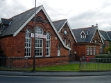
The earliest recorded school was a free school founded in 1730. A School Board was formed in 1876. The girls & infants school was built in 1877, the boys school in 1889. Clowne Junior School is housed in a building opened in October 1984. They have around 350 pupils. Heritage Community SchoolHeritage Mathematics & Computing Specialist School
Heritage Mathematics & Computing Specialist School formally known as Heritage Community School is a Community, comprehensive, for boys and girls, with specialisms in mathematics and computing. It caters for ages 11-16 and is located in Chesterfield, Derbyshire. It is the fastest growing 11-16...
, formerly Clowne Secondary School, on Boughton Lane was awarded specialist Mathematics and Computing School status in 2006. A new school is being built, which will be ready January 2011.
There was a mining college in Clowne and further education is provided by a newly built campus of the Chesterfield College
Chesterfield College
Chesterfield College is a further education further and higher education college in the town of Chesterfield in North East Derbyshire, England. The college consists of three campuses spread over the town of Chesterfield and serves over 21,000 students of which 5,600 are full time attends.- History...
within the town.
Religion
The church of St. John the Baptist is situated on an ancient ridgeway and dates from Norman timesAnglo-Norman
The Anglo-Normans were mainly the descendants of the Normans who ruled England following the Norman conquest by William the Conqueror in 1066. A small number of Normans were already settled in England prior to the conquest...
, the south doorway and chancel arch are of Norman architecture
Norman architecture
About|Romanesque architecture, primarily English|other buildings in Normandy|Architecture of Normandy.File:Durham Cathedral. Nave by James Valentine c.1890.jpg|thumb|200px|The nave of Durham Cathedral demonstrates the characteristic round arched style, though use of shallow pointed arches above the...
. It was partially rebuilt in the Early English and Perpendicular styles. The Norman chancel was rebuilt and enlarged in 1955 when two chapels were added, one dedicated to those who lost their lives in the coal mines.
Early recorded evidence shows the existence of a Primitive Methodist chapel in 1829, although the Ecclesiastical Census Return of 1851 dates the Primitive Methodist Chapel to 1834. A new building was opened in 1877.
The Salvation Army
The Salvation Army
The Salvation Army is a Protestant Christian church known for its thrift stores and charity work. It is an international movement that currently works in over a hundred countries....
meet in Clowne.
Roman Catholics in the area used Southgate House Chapel to celebrate mass. The chapel was built in 1901 by Lady Petre, the second wife of Colonel Butler Bowden. The chapel continued in use until 1950 and is now the dining room of the Van Dyk Hotel. Roman Catholics now worship at the Church of Sacred Heart in Clowne.