
Clarenville, Newfoundland and Labrador
Encyclopedia
Clarenville is a Canadian
town on the east coast of Newfoundland in the province of Newfoundland and Labrador
. Clarenville was incorporated in 1951 and is located in the Shoal Harbour valley fronting an arm of the Atlantic Ocean called Random Sound.
The town grew in importance after it became a junction on the Newfoundland Railway
where a branch line to the Bonavista Peninsula
left the main line. The construction of the Trans-Canada Highway
through the community in the 1960s resulted in it becoming a local service centre for central-eastern Newfoundland, serving 96,000 people living in 90 communities within a 100 km radius{source}. Clarenville is centrally located and within two hours' driving time of 70% of the province’s population.
The town is a natural gateway to the Discovery Trail, extending down the Bonavista Peninsula to Trinity and Bonavista, reputed sight of the first landing of European explorer John Cabot. The trail is a panorama of scenery, historic sites, coastal towns and villages.
, Burin
, and Bonavista
. Route 1 (the Trans-Canada Highway
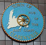
) and Route 230
pass through the town linking Clarenville to the Bonavista Bay area and to the rest of the provincial road network. Because of its geographical location and variety of services, Clarenville is "The Hub of The East Coast".
The Clarenville area has many of the physical features characteristic of the East Coast of Newfoundland and has a marine climate. It lies along the coastal slopes which rise from the Atlantic Ocean towards the interior central plateau of the island. The dominating physical feature is a ridge of broken peaks which rise to heights up to 152 meters above sea level parallel to the coast line. Bare Mountain, with an elevation of 156 meters above sea level, dominates the skyline in the northern part of the town. This ridge falls sharply towards the sea so that its coastal edge is characterized by moderate to severe slopes.
 Towards the southern part of Clarenville, the ridge is broken by a series of valleys which have cut their way through from the coast. The most notable of these is the valley formed by the Lower Shoal Harbour River and Dark Hole Brook and their seaward extension of Lower Shoal Harbour, a shallow and narrow indentation of the sea marked by small rock islands and tidal mud flats. The flats surrounding the river are marshy and subjected to flooding during spring runoff. The river serves as the main drainage course for the area behind the coastal ridge.
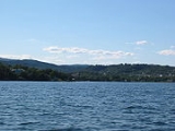
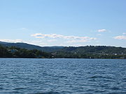
Clarenville has developed in a narrow strip between the coastal ridge and the sea. The average width of the corridor is between 450 to 600 meters. Located at the most westerly end of an in-drift called Random Sound, extending 25 km inland behind Random Island. As probably the deepest, best sheltered, ice-free port on Newfoundland's east coast, Clarenville is suited for commercial shipping and recreational boating.
There are two versions of the origin of Clarenville's name. It has been attributed to a memorial to the Duke of Clarence, eldest son of the then Prince of Wales ( later King Edward VII ) who died in 1892. The other version is that it was named for a son of Prime Minister Sir William Whiteway. However, Sir William had no son by that name. By 1901 Clarenville was the way everyone spelled the name and it has remained that way.
 John Tilley and his family were the first settlers of Lower Shoal Harbour. They traveled from Hants Harbour in 1848 because of the abundance of timber here. "Scholar John " many people referred to him as, because he taught himself how to read and write. As a young man he married Elizabeth Bursey of Old Perlican and they had four sons and six daughters. Being one of the earliest Justices of the Peace licensed to perform marriages in Newfoundland, John Tilley performed the marriage of his own daughter. If we were to look in church records today, we would find that Scholar John's name would appear several times in the late 1830s and 1840s when there was apparently no minister or missionary available. When the Tilleys first arrived the first thing they had to do was to build a log cottage which would be a temporary structure. They later built a saw mill so they could build a standard size home. Along with the saw mill, the Tilleys became involved with fox farming, gardening, coopering, blacksmithing, fishing and fish canning. John Tilley and Sons were the tinning operation to tin salmon in Newfoundland (the first salmon was tinned by Tilley and Sons). Shortly after Scholar John tinned his first salmon he learned of a fishery exhibition. He sent a sample to the exhibition and received a prize in the form of a bronze medal with the inscription: " Warranted to keep free from taint and to retain its purity and nutritious quality, in any climate for many years." Later, Scholar John, Aaron and Moses Tilley ( sons ) with help from John's son-in-law David Palmer, built the first church in Shoal Harbour.
In 1993, Clarenville and Shoal Harbour were amalgamated.
. Nearby are three golf courses, hiking trails, snowmobiling country. Clarenville has the only ski resort east of Corner Brook, White Hills Ski Resort. White Hills is also home to The New Curtain Theatre Company at The Loft Theatre.
.
According to the 2006 Census
Canada
Canada is a North American country consisting of ten provinces and three territories. Located in the northern part of the continent, it extends from the Atlantic Ocean in the east to the Pacific Ocean in the west, and northward into the Arctic Ocean...
town on the east coast of Newfoundland in the province of Newfoundland and Labrador
Newfoundland and Labrador
Newfoundland and Labrador is the easternmost province of Canada. Situated in the country's Atlantic region, it incorporates the island of Newfoundland and mainland Labrador with a combined area of . As of April 2011, the province's estimated population is 508,400...
. Clarenville was incorporated in 1951 and is located in the Shoal Harbour valley fronting an arm of the Atlantic Ocean called Random Sound.
The town grew in importance after it became a junction on the Newfoundland Railway
Newfoundland Railway
The Newfoundland Railway was a railway which operated on the island of Newfoundland from 1898 to 1988. With a total track length of , it was the longest narrow gauge railway system in North America.-Early construction:...
where a branch line to the Bonavista Peninsula
Bonavista Peninsula
The Bonavista Peninsula is a large peninsula on the east coast of the island of Newfoundland in the Canadian province of Newfoundland and Labrador....
left the main line. The construction of the Trans-Canada Highway
Trans-Canada Highway
The Trans-Canada Highway is a federal-provincial highway system that joins the ten provinces of Canada. It is, along with the Trans-Siberian Highway and Australia's Highway 1, one of the world's longest national highways, with the main route spanning 8,030 km...
through the community in the 1960s resulted in it becoming a local service centre for central-eastern Newfoundland, serving 96,000 people living in 90 communities within a 100 km radius{source}. Clarenville is centrally located and within two hours' driving time of 70% of the province’s population.
The town is a natural gateway to the Discovery Trail, extending down the Bonavista Peninsula to Trinity and Bonavista, reputed sight of the first landing of European explorer John Cabot. The trail is a panorama of scenery, historic sites, coastal towns and villages.
Geography
Clarenville is near the center of three peninsulas: AvalonAvalon Peninsula
The Avalon Peninsula is a large peninsula that makes up the southeast portion of the island of Newfoundland.The peninsula is home to 257,223 people, which is approximately 51% of Newfoundland's population in 2009, and is the location of the provincial capital, St. John's. It is connected to the...
, Burin
Burin Peninsula
The Burin Peninsula is a Canadian peninsula located on the south coast of the island of Newfoundland in the province of Newfoundland and Labrador....
, and Bonavista
Bonavista Peninsula
The Bonavista Peninsula is a large peninsula on the east coast of the island of Newfoundland in the Canadian province of Newfoundland and Labrador....
. Route 1 (the Trans-Canada Highway
Trans-Canada Highway
The Trans-Canada Highway is a federal-provincial highway system that joins the ten provinces of Canada. It is, along with the Trans-Siberian Highway and Australia's Highway 1, one of the world's longest national highways, with the main route spanning 8,030 km...
) and Route 230
Newfoundland and Labrador Route 230
Route 230 is the main Bonavista Peninsula Highway, commencing from Route 1 at Thorburn Lake, about 10-15 kilometres north of Clarenville and proceeding all the way to Bonavista at the end of the Peninsula....
pass through the town linking Clarenville to the Bonavista Bay area and to the rest of the provincial road network. Because of its geographical location and variety of services, Clarenville is "The Hub of The East Coast".
The Clarenville area has many of the physical features characteristic of the East Coast of Newfoundland and has a marine climate. It lies along the coastal slopes which rise from the Atlantic Ocean towards the interior central plateau of the island. The dominating physical feature is a ridge of broken peaks which rise to heights up to 152 meters above sea level parallel to the coast line. Bare Mountain, with an elevation of 156 meters above sea level, dominates the skyline in the northern part of the town. This ridge falls sharply towards the sea so that its coastal edge is characterized by moderate to severe slopes.
Clarenville has developed in a narrow strip between the coastal ridge and the sea. The average width of the corridor is between 450 to 600 meters. Located at the most westerly end of an in-drift called Random Sound, extending 25 km inland behind Random Island. As probably the deepest, best sheltered, ice-free port on Newfoundland's east coast, Clarenville is suited for commercial shipping and recreational boating.
History
There is no definite date for the first settlement of what is now Clarenville. William Cowan owned a sawmill at Lower Shoal Harbour around 1848 and this was bought by Joseph Tilley and James Summers of Hants Harbour. They settled here. Settlers also arrived at Dark Hole ( or Dark Harbour). The families that made up this community were the Balsoms, Pearces, Vardys, and Seawards. Settlers also arrived at Brook Cove ( the Burseys ) , Broad Cove ( the Strongs, Adeys) , and Red Beach ( the Stanleys ). These five communities became part of a new community known as Clarenceville in 1892 when the railway came through.There are two versions of the origin of Clarenville's name. It has been attributed to a memorial to the Duke of Clarence, eldest son of the then Prince of Wales ( later King Edward VII ) who died in 1892. The other version is that it was named for a son of Prime Minister Sir William Whiteway. However, Sir William had no son by that name. By 1901 Clarenville was the way everyone spelled the name and it has remained that way.
In 1993, Clarenville and Shoal Harbour were amalgamated.
Recreation
The town held the 1994 Newfoundland Winter Games, the 1997 National Under 17 Men's Softball Tournament, and in November 2010 will host two games of the Four Nations Cup. Clarenville has recreational facilities including a health club with an indoor pool, three softball diamonds (one lit by night), a soccer pitch with a running track, and a recreation complex with three regulation size volleyball courts. The newly constructed Clarenville Events Centre includes a theatre, a rink for hockey, figure skating and curling, and is home to the Clarenville CaribousClarenville Caribous
The Clarenville Caribous are a senior ice hockey team based in Clarenville, Newfoundland and Labrador as part of the Newfoundland Senior Hockey League...
. Nearby are three golf courses, hiking trails, snowmobiling country. Clarenville has the only ski resort east of Corner Brook, White Hills Ski Resort. White Hills is also home to The New Curtain Theatre Company at The Loft Theatre.
567 Random Royal Canadian Air Cadet Squadron
Clarenville has one squadron of around 40 members (Jan 2008) and 5-6 staff. This is the only squadron serving Clarenville, Random Island, George's Brook, Deep Bight, Hillview, and Shoal Harbour. Activities include first aid training, rifle range, drill, power/glider flying and field trips.Demographics
Clarenville is in Division No. 7 on Trinity BayTrinity Bay, Newfoundland and Labrador
Trinity Bay is a large bay on the northeastern coast of Newfoundland in the Canadian province of Newfoundland and Labrador.Major fishing communities include Trinity and Heart's Content.-Industry:...
.
According to the 2006 Census
- Population: 5,274
- % Change (2001–2006): 3.3
- Dwellings: 2,250
- Area (km².): 140.79
- Density (persons per km².): 37.5
| North: Division No. 7, Subd. K Division No. 7, Subd. K, Newfoundland and Labrador Division No. 7, Subd. K is an unorganized subdivision on the Bonavista Peninsula in Newfoundland and Labrador, Canada. It is in Division No. 7 on Trinity Bay.According to the 2001 Statistics Canada Census:*Population: 1,152*% Change : -9.9... | ||
| West: Division No. 7, Subd. E Division No. 7, Subd. E, Newfoundland and Labrador Division No. 7, Subd. E is an unorganized subdivision in eastern Newfoundland, Newfoundland and Labrador, Canada. It is in Division No. 7 on Bonavista Bay.According to the 2001 Statistics Canada Census:*Population: 2,844*% Change : -7.7... , Division No. 7, Subd. K Division No. 7, Subd. K, Newfoundland and Labrador Division No. 7, Subd. K is an unorganized subdivision on the Bonavista Peninsula in Newfoundland and Labrador, Canada. It is in Division No. 7 on Trinity Bay.According to the 2001 Statistics Canada Census:*Population: 1,152*% Change : -9.9... | Clarenville | East: Trinity Bay Trinity Bay, Newfoundland and Labrador Trinity Bay is a large bay on the northeastern coast of Newfoundland in the Canadian province of Newfoundland and Labrador.Major fishing communities include Trinity and Heart's Content.-Industry:... |
| South: Division No. 1, Subd. M Division No. 7, Subd. M, Newfoundland and Labrador Division No. 7, Subdivision M is an unorganised subdivision in eastern Newfoundland, Newfoundland and Labrador, Canada. It is in Division No. 7 on Trinity Bay.According to the 2001 Statistics Canada Census:*Population: 2,365*% Change : -15.8... |
See also
- List of cities and towns in Newfoundland and Labrador
- List of communities in Newfoundland and Labrador