

Cholesbury Camp
Encyclopedia
Cholesbury Camp is a large and well-preserved Iron Age
hill fort
on the northern edge of the village of Cholesbury
in Buckinghamshire
, England
. It is roughly oval-shaped, covers an area of 10 acres (4 ha), and measures approximately 310 m (1,017.1 ft) north-east to south-west by 230 m (754.6 ft) north-west to south-east. The interior is a fairly level plateau and has been used as farmland since the medieval period. The fort is now a scheduled ancient monument
.
 The fort is of the multivallate type, in other words having two or more lines of concentric earthworks. Most examples of such forts were built and used during the British Iron Age
period between the 6th century BC and the Roman invasion of Britain in the 1st century AD. The date of Cholesbury Camp's construction is unclear, but may lie in the 2nd century BC during the Middle Iron Age. It was previously, though erroneously, attributed to the Danes and until the early 20th century was known locally as "The Danish Camp" and incorrectly recorded as such on maps. It has also been suggested that it may have been constructed on the same site as an earlier, "Bronze Age" defensive structure.
The fort is located in the Chiltern Hills
at an altitude of over 190 m (623.4 ft). The porosity of the ground in the area severely limited the availability of surface water, essential for livestock, and therefore precluded year-round settlement adjacent to most of the upland pastures. However, close to the centre of the fort is a water source, called the Holy or Bury Pond. The constancy of this supply, over many hundreds of years, is cited as being crucial to the decision as to where to site the hill fort and for the early establishment of the isolated community at Cholesbury.
The earthen ramparts of the fort are today largely overgrown with a double belt of mature beech trees, planted in the 19th century. Most of the ramparts still remain intact, though they have been removed along a large part of the southern side through building construction between the 16th and early 20th centuries. The ramparts consist principally of two banks (inner and outer) enclosing a large ditch. There are four entrances to the central enclosure, though only one is thought to be original. The inner bank is on average 8 metres (26.2 ft) wide with a height that varies between 0.8 metres (2.6 ft) to 2 metres (6.6 ft). Its front slope is angled at about 35 degrees and the rear slope at 50 degrees. The broad, flat top of the bank does not appear to have been lined with timber or stonework.
The adjoining ditch ranges from 6 metres (19.7 ft) to 12 metres (39.4 ft) wide and 2.5 metres (8.2 ft) to 3 metres (9.8 ft) deep, in the shape of a steep-sided V with an inner slope of about 50 degrees. The outer bank is less distinct but is still visible on the northern side of the fort. Further banks and ditches extend the ramparts to the south-east and to the west, where they are particularly well-preserved for a distance of about 90 metres (295.3 ft).
Excavations by Day Kimball in 1932 indicated that during the Iron Ages, Cholesbury Camp was only sparsely and possibly intermittently inhabited, presumably in times of strife when it provided a refuge or a defensive position. Well-preserved remains of prehistoric hearths or fire-sites and the remains of a clay-lined oven were found. Three of the hearths appear to have been used to smelt iron. Numerous fragments of pottery were found dating from the Middle Iron Age to the Late Iron Age (approximately 300BC-50AD). The main period of occupation appears to have been around the middle of the 1st century BC.
From the time of the Roman occupation in 54AD until the early medieval period the hill fort was probably deserted. The initial satellite settlement was originally associated with nearby Drayton Beauchamp
and from which the present-day village of Cholesbury had been founded during the late Anglo-Saxon
settlement. The first record of the settlement's name, as Chelwoldesbyr, was at the end of the 13th century. The name derives from the Anglo-Saxon Ceolweald's burh (i.e. the fortified place of Ceolweald's people).
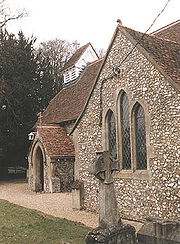
Today the Church of St Lawrence is located within the remains of the defences of the Iron Age fort, one of two such churches of the same name built within a hill fort in Buckinghamshire. Its location suggests that the fort still had some kind of politico-religious significance long after its original use had been forgotten. The oldest parts of the present church date back to the 12-13th century, possibly replacing an earlier Anglo-Saxon wooden church. After falling into disrepair the church was partly rebuilt and restored in the 1870s in the Victorian style. A geophysical survey carried out in the interior of the fort in July 2000 found evidence that the interior had been reoccupied in the medieval period, possibly by the construction of Cholesbury Manor House
and an associated small settlement.
Iron Age
The Iron Age is the archaeological period generally occurring after the Bronze Age, marked by the prevalent use of iron. The early period of the age is characterized by the widespread use of iron or steel. The adoption of such material coincided with other changes in society, including differing...
hill fort
Hill fort
A hill fort is a type of earthworks used as a fortified refuge or defended settlement, located to exploit a rise in elevation for defensive advantage. They are typically European and of the Bronze and Iron Ages. Some were used in the post-Roman period...
on the northern edge of the village of Cholesbury
Cholesbury
Cholesbury is a village in Buckinghamshire, England, on the border with Hertfordshire. It is situated in the Chiltern Hills, about east of Wendover, north of Chesham and from Berkhamsted....
in Buckinghamshire
Buckinghamshire
Buckinghamshire is a ceremonial and non-metropolitan home county in South East England. The county town is Aylesbury, the largest town in the ceremonial county is Milton Keynes and largest town in the non-metropolitan county is High Wycombe....
, England
England
England is a country that is part of the United Kingdom. It shares land borders with Scotland to the north and Wales to the west; the Irish Sea is to the north west, the Celtic Sea to the south west, with the North Sea to the east and the English Channel to the south separating it from continental...
. It is roughly oval-shaped, covers an area of 10 acres (4 ha), and measures approximately 310 m (1,017.1 ft) north-east to south-west by 230 m (754.6 ft) north-west to south-east. The interior is a fairly level plateau and has been used as farmland since the medieval period. The fort is now a scheduled ancient monument
Scheduled Ancient Monument
In the United Kingdom, a scheduled monument is a 'nationally important' archaeological site or historic building, given protection against unauthorized change. The various pieces of legislation used for legally protecting heritage assets from damage and destruction are grouped under the term...
.
British Iron Age
The British Iron Age is a conventional name used in the archaeology of Great Britain, referring to the prehistoric and protohistoric phases of the Iron-Age culture of the main island and the smaller islands, typically excluding prehistoric Ireland, and which had an independent Iron Age culture of...
period between the 6th century BC and the Roman invasion of Britain in the 1st century AD. The date of Cholesbury Camp's construction is unclear, but may lie in the 2nd century BC during the Middle Iron Age. It was previously, though erroneously, attributed to the Danes and until the early 20th century was known locally as "The Danish Camp" and incorrectly recorded as such on maps. It has also been suggested that it may have been constructed on the same site as an earlier, "Bronze Age" defensive structure.
The fort is located in the Chiltern Hills
Chiltern Hills
The Chiltern Hills form a chalk escarpment in South East England. They are known locally as "the Chilterns". A large portion of the hills was designated officially as an Area of Outstanding Natural Beauty in 1965.-Location:...
at an altitude of over 190 m (623.4 ft). The porosity of the ground in the area severely limited the availability of surface water, essential for livestock, and therefore precluded year-round settlement adjacent to most of the upland pastures. However, close to the centre of the fort is a water source, called the Holy or Bury Pond. The constancy of this supply, over many hundreds of years, is cited as being crucial to the decision as to where to site the hill fort and for the early establishment of the isolated community at Cholesbury.
The earthen ramparts of the fort are today largely overgrown with a double belt of mature beech trees, planted in the 19th century. Most of the ramparts still remain intact, though they have been removed along a large part of the southern side through building construction between the 16th and early 20th centuries. The ramparts consist principally of two banks (inner and outer) enclosing a large ditch. There are four entrances to the central enclosure, though only one is thought to be original. The inner bank is on average 8 metres (26.2 ft) wide with a height that varies between 0.8 metres (2.6 ft) to 2 metres (6.6 ft). Its front slope is angled at about 35 degrees and the rear slope at 50 degrees. The broad, flat top of the bank does not appear to have been lined with timber or stonework.
The adjoining ditch ranges from 6 metres (19.7 ft) to 12 metres (39.4 ft) wide and 2.5 metres (8.2 ft) to 3 metres (9.8 ft) deep, in the shape of a steep-sided V with an inner slope of about 50 degrees. The outer bank is less distinct but is still visible on the northern side of the fort. Further banks and ditches extend the ramparts to the south-east and to the west, where they are particularly well-preserved for a distance of about 90 metres (295.3 ft).
Excavations by Day Kimball in 1932 indicated that during the Iron Ages, Cholesbury Camp was only sparsely and possibly intermittently inhabited, presumably in times of strife when it provided a refuge or a defensive position. Well-preserved remains of prehistoric hearths or fire-sites and the remains of a clay-lined oven were found. Three of the hearths appear to have been used to smelt iron. Numerous fragments of pottery were found dating from the Middle Iron Age to the Late Iron Age (approximately 300BC-50AD). The main period of occupation appears to have been around the middle of the 1st century BC.
From the time of the Roman occupation in 54AD until the early medieval period the hill fort was probably deserted. The initial satellite settlement was originally associated with nearby Drayton Beauchamp
Drayton Beauchamp
Drayton Beauchamp is a village and civil parish within Aylesbury Vale district in Buckinghamshire, England. It is in the east of the county, near the border boundary Hertfordshire, about six miles from Aylesbury and two miles from Tring.-History:...
and from which the present-day village of Cholesbury had been founded during the late Anglo-Saxon
Anglo-Saxon
Anglo-Saxon may refer to:* Anglo-Saxons, a group that invaded Britain** Old English, their language** Anglo-Saxon England, their history, one of various ships* White Anglo-Saxon Protestant, an ethnicity* Anglo-Saxon economy, modern macroeconomic term...
settlement. The first record of the settlement's name, as Chelwoldesbyr, was at the end of the 13th century. The name derives from the Anglo-Saxon Ceolweald's burh (i.e. the fortified place of Ceolweald's people).
Today the Church of St Lawrence is located within the remains of the defences of the Iron Age fort, one of two such churches of the same name built within a hill fort in Buckinghamshire. Its location suggests that the fort still had some kind of politico-religious significance long after its original use had been forgotten. The oldest parts of the present church date back to the 12-13th century, possibly replacing an earlier Anglo-Saxon wooden church. After falling into disrepair the church was partly rebuilt and restored in the 1870s in the Victorian style. A geophysical survey carried out in the interior of the fort in July 2000 found evidence that the interior had been reoccupied in the medieval period, possibly by the construction of Cholesbury Manor House
Cholesbury Manor House
Cholesbury Manor House which is close to the centre of Cholesbury, Buckinghamshire is where the Lord of the Manor held his Court periodically between 1599 and 1607. The building dates back to the end of the 16th century. It is a Grade II Listed Building....
and an associated small settlement.