
Charlotte Route 4
Encyclopedia
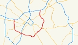
Route 4 is an 18.6-mile partial ring road
around Uptown Charlotte, North Carolina
, United States
, marked along four-lane state-maintained secondary roads; it is sometimes considered to use Interstate 85 to complete the loop, though this part is not signed. The route is posted by the Charlotte Department of Transportation using a modified pentagonal county road shield, with a green background and the city's crown logo above the number. The loop has a radius of about four miles (6 km), hence the number. Although most of the route, where it does not use I-85, is a typical four-lane surface road, the western section is the limited-access Billy Graham Parkway, connecting I-77 and I-85 with the Charlotte/Douglas International Airport
.
Billy Graham
, and is a limited-access road
, meaning that abutting property owners cannot construct driveway
s. After crossing Scott Futrell Drive, the south frontage road
of I-85, the parkway crosses over Wilkinson Boulevard (US 29
/US 74
); access between the two roads is indirect, via Boyer Street, Morris Field Drive or another piece of Mulberry Church Road. The few intersections on Billy Graham Parkway include a trumpet interchange with Josh Birmingham Parkway, the main access to Charlotte/Douglas International Airport
, an intersection with West Boulevard (NC 160), and a partial cloverleaf interchange with Tyvola Road near Paul Buck Boulevard. Billy Graham Parkway ends at South Tryon Street
(NC 49), where Route 4 continues east on Woodlawn Road. Woodlawn Road crosses Bill Lee Freeway (I-77
/US 21
).
Access to the Freeway is unique, with southbound Route 4 drivers needing to go on South Tryon Street (North) to access I-77/US 21 North. This is also true for drivers on the freeway to take Exit 6B (South Tryon Street/Billy Graham Parkway) instead of Exit 6A (Woodlawn Road), to travel northbound Route 4.
Woodlawn Road, and the rest of Route 4, is a more typical four-lane arterial road
with numerous driveways. Shortly after crossing I-77/US 21, Route 4 meets South Boulevard, where US 521
used to turn south off Woodlawn Road (coming from Billy Graham Parkway). The road continues east, eventually crossing Selwyn Avenue and becoming Runnymede Lane, which ends at Sharon Road after several curves. A short jog north on Sharon Road takes Route 4 to the beginning of Wendover Road; in either direction, two lanes turn to and from Sharon Road, maintaining a four-lane cross section on Route 4. Wendover Road soon crosses Providence Road (NC 16), and becomes Eastway Drive at a cloverleaf interchange
with Independence Boulevard (US 74
/NC 27). Eastway Drive runs north to North Tryon Street
(US 29
/NC 49), but Route 4 does not follow the entire road, instead forking northwest on Sugar Creek Road. Unlike the turns at Sharon Road, this turn only has one lane in each direction. Sugar Creek Road crosses North Tryon Street (US 29/NC 49) and then I-85
at exit 41, where Route 4 ends. The road however continues north through Derita
, leading part of the way to Huntersville
.
Signing for Route 4 is very scarce, and neither I-85 nor I-77 recognize Route 4 on exit signs for the road.
(NC 49) east to Fairfax Drive, was through-routed with Runnymede Lane via a new bridge across Briar Creek and a short piece of Barclay Downs Drive. Wendover Road was extended northeast from its end at Randolph Road to Independence Boulevard (US 74), absorbing a short piece of Beal Street (east of Ellington Street) and most of Brookhurst Drive (Monroe Road to just shy of Independence Boulevard). Eastway Drive was already complete, and Sugar Creek Road only required a railroad bridge between The Plaza and Atmore Street, which allowed the short Highway Place to become part of Sugar Creek Road. These roads, along with a proposed southwestern segment that would partially replace Yorkmont Road, were added to the state highway system (where not already part of it) as secondary roads, and, except for Sugar Creek Road, to the federal-aid primary system. Not every turn was eliminated; plans for a straighter Runnymede Lane west of Colony Road and a bypass of Sharon Road were not carried through.
The first portions to be completed as four-lane roads were Woodlawn Road and the segment north of Monroe Road, including the cloverleaf interchange
with Independence Boulevard, where there had been a five-way intersection (with Commonwealth Avenue crossing through). The rest of the eastern half was finished in the late 1970s, at which time the Charlotte DOT chose the "Route 4" label, in order to give the road one designation but avoid renaming the existing street names. The remainder of the loop was completed in 1981, connecting to an existing I-85 interchange that served Mulberry Church Road, and was named after Reverend Billy Graham
, a Charlotte-born evangelist
. This portion, being a new roadway, was built to higher standards, with interchange
s at several major intersections and no driveway access
. US 521, which had ended uptown at US 29 via mainly South Boulevard, was moved onto the Billy Graham Parkway via a short piece of Woodlawn Road, taking US 521 to a new terminus at I-85 west of uptown. The American Association of State Highway and Transportation Officials
approved truncating US 521 to I-485, the new outer beltway, in May 2003, and now the entire length of Route 4 is a secondary road.
Ring road
A ring road, orbital motorway, beltway, circumferential highway, or loop highway is a road that encircles a town or city...
around Uptown Charlotte, North Carolina
North Carolina
North Carolina is a state located in the southeastern United States. The state borders South Carolina and Georgia to the south, Tennessee to the west and Virginia to the north. North Carolina contains 100 counties. Its capital is Raleigh, and its largest city is Charlotte...
, United States
United States
The United States of America is a federal constitutional republic comprising fifty states and a federal district...
, marked along four-lane state-maintained secondary roads; it is sometimes considered to use Interstate 85 to complete the loop, though this part is not signed. The route is posted by the Charlotte Department of Transportation using a modified pentagonal county road shield, with a green background and the city's crown logo above the number. The loop has a radius of about four miles (6 km), hence the number. Although most of the route, where it does not use I-85, is a typical four-lane surface road, the western section is the limited-access Billy Graham Parkway, connecting I-77 and I-85 with the Charlotte/Douglas International Airport
Charlotte/Douglas International Airport
Charlotte Douglas International Airport is a joint civil-military public international airport located in Charlotte, North Carolina. Established in 1935 as Charlotte Municipal Airport, in 1954 the airport was renamed Douglas Municipal Airport after former Charlotte mayor Ben Elbert Douglas, Sr...
.
Route description
The west end of Route 4 is at exit 33 of I-85; local traffic can continue north on the short Mulberry Church Road. This part of Route 4 is named Billy Graham Parkway, after evangelistEvangelism
Evangelism refers to the practice of relaying information about a particular set of beliefs to others who do not hold those beliefs. The term is often used in reference to Christianity....
Billy Graham
Billy Graham
William Franklin "Billy" Graham, Jr. is an American evangelical Christian evangelist. As of April 25, 2010, when he met with Barack Obama, Graham has spent personal time with twelve United States Presidents dating back to Harry S. Truman, and is number seven on Gallup's list of admired people for...
, and is a limited-access road
Limited-access road
A limited-access road known by various terms worldwide, including limited-access highway, dual-carriageway and expressway, is a highway or arterial road for high-speed traffic which has many or most characteristics of a controlled-access highway , including limited or no access to adjacent...
, meaning that abutting property owners cannot construct driveway
Driveway
A driveway is a type of private road for local access to one or a small group of structures, and is owned and maintained by an individual or group....
s. After crossing Scott Futrell Drive, the south frontage road
Frontage road
A frontage road is a non-limited access road running parallel to a higher-speed road, usually a freeway, and feeding it at appropriate points of access...
of I-85, the parkway crosses over Wilkinson Boulevard (US 29
U.S. Route 29
U.S. Route 29 is a north–south United States highway that runs for from the western suburbs of Baltimore, Maryland, to Pensacola, Florida. This highway's northern terminus is at Maryland Route 99 in Ellicott City, Maryland...
/US 74
U.S. Route 74
U.S. Route 74 is an east–west United States highway that runs for from Cleveland, Tennessee to Wrightsville Beach, North Carolina.-Tennessee:Established in 1987, US-74 western terminus is exit 20 on I-75 in Cleveland...
); access between the two roads is indirect, via Boyer Street, Morris Field Drive or another piece of Mulberry Church Road. The few intersections on Billy Graham Parkway include a trumpet interchange with Josh Birmingham Parkway, the main access to Charlotte/Douglas International Airport
Charlotte/Douglas International Airport
Charlotte Douglas International Airport is a joint civil-military public international airport located in Charlotte, North Carolina. Established in 1935 as Charlotte Municipal Airport, in 1954 the airport was renamed Douglas Municipal Airport after former Charlotte mayor Ben Elbert Douglas, Sr...
, an intersection with West Boulevard (NC 160), and a partial cloverleaf interchange with Tyvola Road near Paul Buck Boulevard. Billy Graham Parkway ends at South Tryon Street
Tryon Street
Tryon Street is a major north-south street of Charlotte, North Carolina. It traverses through the center of Uptown Charlotte and is the address for some of the city's tallest buildings like the Bank of America Corporate Center and Hearst Tower. U.S...
(NC 49), where Route 4 continues east on Woodlawn Road. Woodlawn Road crosses Bill Lee Freeway (I-77
Interstate 77 in North Carolina
In the U.S. state of North Carolina, Interstate 77 is a Interstate Highway, which serves the city of Charlotte and the Western Piedmont.-Route description:...
/US 21
U.S. Route 21
U.S. Route 21 is a north–south United States highway of , from Hunting Island State Park, South Carolina to Wytheville, Virginia.-South Carolina:...
).
Access to the Freeway is unique, with southbound Route 4 drivers needing to go on South Tryon Street (North) to access I-77/US 21 North. This is also true for drivers on the freeway to take Exit 6B (South Tryon Street/Billy Graham Parkway) instead of Exit 6A (Woodlawn Road), to travel northbound Route 4.
Woodlawn Road, and the rest of Route 4, is a more typical four-lane arterial road
Arterial road
An arterial road, or arterial thoroughfare, is a high-capacity urban road. The primary function of an arterial road is to deliver traffic from collector roads to freeways, and between urban centres at the highest level of service possible. As such, many arteries are limited-access roads, or feature...
with numerous driveways. Shortly after crossing I-77/US 21, Route 4 meets South Boulevard, where US 521
U.S. Route 521
U.S. Route 521 is an north–south United States highway that runs for from Georgetown, South Carolina to Charlotte, North Carolina.-South Carolina:...
used to turn south off Woodlawn Road (coming from Billy Graham Parkway). The road continues east, eventually crossing Selwyn Avenue and becoming Runnymede Lane, which ends at Sharon Road after several curves. A short jog north on Sharon Road takes Route 4 to the beginning of Wendover Road; in either direction, two lanes turn to and from Sharon Road, maintaining a four-lane cross section on Route 4. Wendover Road soon crosses Providence Road (NC 16), and becomes Eastway Drive at a cloverleaf interchange
Cloverleaf interchange
A cloverleaf interchange is a two-level interchange in which left turns, reverse direction in left-driving regions, are handled by ramp roads...
with Independence Boulevard (US 74
U.S. Route 74
U.S. Route 74 is an east–west United States highway that runs for from Cleveland, Tennessee to Wrightsville Beach, North Carolina.-Tennessee:Established in 1987, US-74 western terminus is exit 20 on I-75 in Cleveland...
/NC 27). Eastway Drive runs north to North Tryon Street
Tryon Street
Tryon Street is a major north-south street of Charlotte, North Carolina. It traverses through the center of Uptown Charlotte and is the address for some of the city's tallest buildings like the Bank of America Corporate Center and Hearst Tower. U.S...
(US 29
U.S. Route 29
U.S. Route 29 is a north–south United States highway that runs for from the western suburbs of Baltimore, Maryland, to Pensacola, Florida. This highway's northern terminus is at Maryland Route 99 in Ellicott City, Maryland...
/NC 49), but Route 4 does not follow the entire road, instead forking northwest on Sugar Creek Road. Unlike the turns at Sharon Road, this turn only has one lane in each direction. Sugar Creek Road crosses North Tryon Street (US 29/NC 49) and then I-85
Interstate 85 in North Carolina
In the U.S. state of North Carolina, Interstate 85 scales the state for from the South Carolina border to the Virginia border. As the second-longest interstate in the state , it provides an important link between the cities of Atlanta, Georgia, Charlotte, Greensboro, Richmond, Virginia and...
at exit 41, where Route 4 ends. The road however continues north through Derita
Derita
The Derita Community is located several miles north of Charlotte NC's center city, is bordered by I-77 to the west, I-85 to the east, the University area and WT Harris Blvd to the north...
, leading part of the way to Huntersville
Huntersville, North Carolina
Huntersville is a large town in Mecklenburg and Cabarrus Counties, North Carolina, United States. The population was 46,773 at the 2010 census, which makes Huntersville the 19th largest city in North Carolina. It is located about 12 miles north of uptown Charlotte. It is thought that the town...
.
Signing for Route 4 is very scarce, and neither I-85 nor I-77 recognize Route 4 on exit signs for the road.
History
The idea of a ring around uptown, roughly along what were the city limits at the time, was first suggested in the 1960 city transportation plan. In order to implement this, a number of existing two-lane roads around the south and east sides of Charlotte were connected and widened. Woodlawn Street, then running from Tryon StreetTryon Street
Tryon Street is a major north-south street of Charlotte, North Carolina. It traverses through the center of Uptown Charlotte and is the address for some of the city's tallest buildings like the Bank of America Corporate Center and Hearst Tower. U.S...
(NC 49) east to Fairfax Drive, was through-routed with Runnymede Lane via a new bridge across Briar Creek and a short piece of Barclay Downs Drive. Wendover Road was extended northeast from its end at Randolph Road to Independence Boulevard (US 74), absorbing a short piece of Beal Street (east of Ellington Street) and most of Brookhurst Drive (Monroe Road to just shy of Independence Boulevard). Eastway Drive was already complete, and Sugar Creek Road only required a railroad bridge between The Plaza and Atmore Street, which allowed the short Highway Place to become part of Sugar Creek Road. These roads, along with a proposed southwestern segment that would partially replace Yorkmont Road, were added to the state highway system (where not already part of it) as secondary roads, and, except for Sugar Creek Road, to the federal-aid primary system. Not every turn was eliminated; plans for a straighter Runnymede Lane west of Colony Road and a bypass of Sharon Road were not carried through.
The first portions to be completed as four-lane roads were Woodlawn Road and the segment north of Monroe Road, including the cloverleaf interchange
Cloverleaf interchange
A cloverleaf interchange is a two-level interchange in which left turns, reverse direction in left-driving regions, are handled by ramp roads...
with Independence Boulevard, where there had been a five-way intersection (with Commonwealth Avenue crossing through). The rest of the eastern half was finished in the late 1970s, at which time the Charlotte DOT chose the "Route 4" label, in order to give the road one designation but avoid renaming the existing street names. The remainder of the loop was completed in 1981, connecting to an existing I-85 interchange that served Mulberry Church Road, and was named after Reverend Billy Graham
Billy Graham
William Franklin "Billy" Graham, Jr. is an American evangelical Christian evangelist. As of April 25, 2010, when he met with Barack Obama, Graham has spent personal time with twelve United States Presidents dating back to Harry S. Truman, and is number seven on Gallup's list of admired people for...
, a Charlotte-born evangelist
Evangelism
Evangelism refers to the practice of relaying information about a particular set of beliefs to others who do not hold those beliefs. The term is often used in reference to Christianity....
. This portion, being a new roadway, was built to higher standards, with interchange
Interchange (road)
In the field of road transport, an interchange is a road junction that typically uses grade separation, and one or more ramps, to permit traffic on at least one highway to pass through the junction without directly crossing any other traffic stream. It differs from a standard intersection, at which...
s at several major intersections and no driveway access
Limited-access road
A limited-access road known by various terms worldwide, including limited-access highway, dual-carriageway and expressway, is a highway or arterial road for high-speed traffic which has many or most characteristics of a controlled-access highway , including limited or no access to adjacent...
. US 521, which had ended uptown at US 29 via mainly South Boulevard, was moved onto the Billy Graham Parkway via a short piece of Woodlawn Road, taking US 521 to a new terminus at I-85 west of uptown. The American Association of State Highway and Transportation Officials
American Association of State Highway and Transportation Officials
AASHTO, the American Association of State Highway and Transportation Officials, is a standards setting body which publishes specifications, test protocols and guidelines which are used in highway design and construction throughout the United States...
approved truncating US 521 to I-485, the new outer beltway, in May 2003, and now the entire length of Route 4 is a secondary road.
Major intersections
| Mile | Road(s) | Notes |
|---|---|---|
| 0.00 | ||
| 0.50 | ||
| 1.19 | Charlotte/Douglas International Airport Charlotte/Douglas International Airport Charlotte Douglas International Airport is a joint civil-military public international airport located in Charlotte, North Carolina. Established in 1935 as Charlotte Municipal Airport, in 1954 the airport was renamed Douglas Municipal Airport after former Charlotte mayor Ben Elbert Douglas, Sr... |
|
| 2.34 | ||
| 3.23 | Tyvola Road - Coliseum Charlotte Coliseum The Charlotte Coliseum was a multi-purpose sports and entertainment arena in Charlotte, North Carolina. It was operated by the Charlotte Coliseum Authority, which also oversees the operation of Bojangles' Coliseum, the Charlotte Convention Center, and Ovens Auditorium... Area |
|
| 5.13 | ||
| 5.30 | - Rock Hill | |
| 5.96 | South Boulevard | Former US 521 |
| 9.33 | Sharon Road south | |
| 10.10 | ||
| 12.70 | ||
| 15.73 | Eastway Drive north | |
| 16.28 | The Plaza | |
| 17.18 | ||
| 18.61 |
See also
- Interstate 277Interstate 277 (North Carolina)Interstate 277 is a loop in central Charlotte, North Carolina. The southern terminus is located on the southwest side of downtown. I-277 loops around the downtown area and reconnects with I-77/U.S. 21 north of uptown...
, Charlotte's inner freeway loop - Interstate 485, Charlotte's outer freeway loop
- W.T. Harris Boulevard, a surface road in the northeast quadrant, forming a partial loop between Route 4 and I-485
- Pittsburgh/Allegheny County Belt SystemPittsburgh/Allegheny County Belt SystemThe Allegheny County Belt System color codes miscellaneous county roads to form a unique system of routes in Allegheny County, Pennsylvania and around the city of Pittsburgh....
, a system of similar loops in Pennsylvania