
Chakrata
Encyclopedia
Chakrata or Chakrauta is a cantonment
town in Dehradun district
in the state of Uttarakhand
, India
.
It is situated between the Tons
and Yamuna
rivers, at an elevation of 7000–7250 feet, 92 km from state capital, Dehradun
, it was originally a cantonment of British Indian Army
. Due west lies Himachal Pradesh
, and due east are Mussoorie
(73 km), Garhwal
.
, a nearby village, belonging to the Jaunsari tribe, which still has a marked presence in the surrounding villages.
A cantonment of British Indian Army, was established in 1866 by Colonel Hume of the 55th Regiment, British Indian Army, and the troops and officers first occupied the cantonment in April 1869.
 In 1901, Chakrata Tahsil was part of the Dehradun district, of United Provinces, with a collective population of 51,101, which consisted of the towns of Chakrata (population 1250) and Kalsi, with a population of 760 , which is most known for the rock edict of the Mauryan king Ashoka
2nd century BC, first discovered by John Forest, in 1860.
, also known as Establishment 22 ( called "Two-Two"), the only ethnic Tibetan
unit of the Indian Army, which was raised after the Indo-China War of 1962. Various kinds of weapons and survival training is also imparted by R&AW
and other intelligence services in Chakrata, in support of various Indian foreign policy goals, especially pertaining to other countries in the Indian Subcontinent.
who was sacked at the last moment had criticized the Government's claim that the attack represented a "last resort", stating that the attack was planned a year and a half prior to the actual day of attack. S. K. Sinha and Mark Tully report that the army had been rehearsing the attack in a replica of the Golden Temple
at a secret location near Chakrata Cantonment in the Doon Valley.
via Mussoorie
or Vikasnagar. Both routes pass through beautiful mountainous road. Travelling in the monsoon can be quite tricky as the area sees frequent road blockages due to landslides.
The area has an abundance of conifers, rhododendrons and oaks. The red rhododendrons are the most abundantly found in this region.
A key attraction near Chakrata is the waterfall named Tiger Fall. A secluded -nearby, leafy hamlet of Deoban offers a panoramic view of the Himalayas
stretching from Kinnaur to Garhwal and Kumaon.
The region also has a number of temples including ones at Hanol, Mahasu Devta Temple
dedicated to Lord Mahasu (Though this is still a topic of discussion that Lord Mahasu is Lord Mahashiva or Lord Ramchnadra), Radina, Thaina, Indroli, Lakhwar, and Lakhamandal, on the banks of river Yamuna, known for its ancient Shiva Temple, which traces its existence to the legends of Mahabharata
, the village also has several natural caves .
The alpine meadows of Mundali (2776 mts.), offers skiing opportunities, November to April.
There are approx. 2-3 basic private hotels in Chakrata, and some dhabas. Petrol and diesel are hard to come by (for civilians), but can be obtained in small quantities from local traders. The most famous hotel of chakrata is Hotel Himalayan Paradise and Hotel Snow View(estd 1936).
, Chakrata had a population of 3497, belonging to the Jaunsari tribe. Males constitute 62% of the population and females 38%. Chakrata has an average literacy rate of 75%, higher than the national average of 59.5%; w
ith male literacy of 81% and female literacy of 65%. 12% of the population is under 6 years of age.
Cantonment
A cantonment is a temporary or semi-permanent military or police quarters. The word cantonment is derived from the French word canton meaning corner or district, as is the name of the Cantons of Switzerland. In South Asia, the term cantonment also describes permanent military stations...
town in Dehradun district
Dehradun district
There are five railway stations in Dehradun:* Raiwala* Rishikesh* Doiwala* Harrawala* DehradunAirport...
in the state of Uttarakhand
Uttarakhand
Uttarakhand , formerly Uttaranchal, is a state in the northern part of India. It is often referred to as the Land of Gods due to the many holy Hindu temples and cities found throughout the state, some of which are among Hinduism's most spiritual and auspicious places of pilgrimage and worship...
, India
India
India , officially the Republic of India , is a country in South Asia. It is the seventh-largest country by geographical area, the second-most populous country with over 1.2 billion people, and the most populous democracy in the world...
.
It is situated between the Tons
Tons River
The Tons is the largest tributary of the Yamuna and flows through Garhwal region in Uttarakhand, touching Himachal Pradesh. The Tons thrust is named after this river....
and Yamuna
Yamuna
The Yamuna is the largest tributary river of the Ganges in northern India...
rivers, at an elevation of 7000–7250 feet, 92 km from state capital, Dehradun
Dehradun
- Geography :The Dehradun district has various types of physical geography from Himalayan mountains to Plains. Raiwala is the lowest point at 315 meters above sea level, and the highest points are within the Tiuni hills, rising to 3700 m above sea level...
, it was originally a cantonment of British Indian Army
British Indian Army
The British Indian Army, officially simply the Indian Army, was the principal army of the British Raj in India before the partition of India in 1947...
. Due west lies Himachal Pradesh
Himachal Pradesh
Himachal Pradesh is a state in Northern India. It is spread over , and is bordered by the Indian states of Jammu and Kashmir on the north, Punjab on the west and south-west, Haryana and Uttar Pradesh on the south, Uttarakhand on the south-east and by the Tibet Autonomous Region on the east...
, and due east are Mussoorie
Mussoorie
Mussoorie is a city and a municipal board in the Dehradun District of the northern Indian state of Uttarakhand. It is located about 35 km from the state capital of Dehradun and 290 km north from the national capital of New Delhi...
(73 km), Garhwal
Garhwal Division
Garhwal is the north-western region and administrative division of the northern Indian state of Uttarakhand which is home to the Garhwali people. Lying in the Himalayas, It is bounded on the north by Tibet, on the east by Kumaon region, on the south by Uttar Pradesh state, and on the north-west by...
.
History
The area was earlier known as Jaunsar bawarJaunsar bawar
Jaunsar-Bawar is a hilly region, 85 km from Mussoorie, in Chakrata tehsil, in Dehradun district, it represents the geographical region inhabited by the 'Jaunsari' tribe, which traces its origin from the Pandavas of Mahabharata....
, a nearby village, belonging to the Jaunsari tribe, which still has a marked presence in the surrounding villages.
A cantonment of British Indian Army, was established in 1866 by Colonel Hume of the 55th Regiment, British Indian Army, and the troops and officers first occupied the cantonment in April 1869.
Ashoka
Ashok Maurya or Ashoka , popularly known as Ashoka the Great, was an Indian emperor of the Maurya Dynasty who ruled almost all of the Indian subcontinent from ca. 269 BC to 232 BC. One of India's greatest emperors, Ashoka reigned over most of present-day India after a number of military conquests...
2nd century BC, first discovered by John Forest, in 1860.
The cantonment
Chakrata is an access-restricted military cantonment, and foreigners face severe restrictions in visiting. Notably, it is the permanent garrison of the secretive and elite Special Frontier ForceSpecial Frontier Force
The Special Frontier Force is a paramilitary unit of India. It was conceived in the post Sino-Indian war period as a guerrilla force composed mainly of Tibetan refugees whose main goal was to conduct covert operations behind Chinese lines in case of another war between the People's Republic of...
, also known as Establishment 22 ( called "Two-Two"), the only ethnic Tibetan
Tibetan people
The Tibetan people are an ethnic group that is native to Tibet, which is mostly in the People's Republic of China. They number 5.4 million and are the 10th largest ethnic group in the country. Significant Tibetan minorities also live in India, Nepal, and Bhutan...
unit of the Indian Army, which was raised after the Indo-China War of 1962. Various kinds of weapons and survival training is also imparted by R&AW
Research and Analysis Wing
The Research and Analysis Wing is India's external intelligence agency. It was formed in September 1968 after the poor performance of the Intelligence Bureau in the Sino-Indian war of 1962 and the India-Pakistani war of 1965 convinced the then government of India that a specialized, independent...
and other intelligence services in Chakrata, in support of various Indian foreign policy goals, especially pertaining to other countries in the Indian Subcontinent.
Operation Bluestar
The attack on Golden Temple was in plans even before the armed Sikh militants fortified it. Then GOC of the Indian Army, S. K. SinhaS. K. Sinha
Lieutenant General Srinivas Kumar Sinha, PVSM is an Indian soldier. After his retirement, he served as Governor of the states of Jammu and Kashmir and Assam.-Early life:...
who was sacked at the last moment had criticized the Government's claim that the attack represented a "last resort", stating that the attack was planned a year and a half prior to the actual day of attack. S. K. Sinha and Mark Tully report that the army had been rehearsing the attack in a replica of the Golden Temple
Harmandir Sahib
The Harmandir Sahib also Darbar Sahib , also referred to as the Golden Temple, is a prominent Sikh gurdwara located in the city of Amritsar, Punjab . Construction of the gurdwara was begun by Guru Ram Das, the fourth Sikh Guru, and completed by his successor, Guru Arjan Dev...
at a secret location near Chakrata Cantonment in the Doon Valley.
Local attractions
Chakrata can be reached from DehradunDehradun
- Geography :The Dehradun district has various types of physical geography from Himalayan mountains to Plains. Raiwala is the lowest point at 315 meters above sea level, and the highest points are within the Tiuni hills, rising to 3700 m above sea level...
via Mussoorie
Mussoorie
Mussoorie is a city and a municipal board in the Dehradun District of the northern Indian state of Uttarakhand. It is located about 35 km from the state capital of Dehradun and 290 km north from the national capital of New Delhi...
or Vikasnagar. Both routes pass through beautiful mountainous road. Travelling in the monsoon can be quite tricky as the area sees frequent road blockages due to landslides.
The area has an abundance of conifers, rhododendrons and oaks. The red rhododendrons are the most abundantly found in this region.
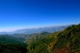
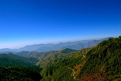
A key attraction near Chakrata is the waterfall named Tiger Fall. A secluded -nearby, leafy hamlet of Deoban offers a panoramic view of the Himalayas
Himalayas
The Himalaya Range or Himalaya Mountains Sanskrit: Devanagari: हिमालय, literally "abode of snow"), usually called the Himalayas or Himalaya for short, is a mountain range in Asia, separating the Indian subcontinent from the Tibetan Plateau...
stretching from Kinnaur to Garhwal and Kumaon.
The region also has a number of temples including ones at Hanol, Mahasu Devta Temple
Mahasu Devta Temple
Mahasu Devta Temple is located on the Tyuni-Mori road at Hanol. The Temple is dedicated to Mahasu Devta, Lord Mahasu is the chief Deity of this area and is worshipped in Mahasu Devta Temple by the people of Hanol and nearby villages. The temple is the ancient temple of Mahasu Devta built in 9th...
dedicated to Lord Mahasu (Though this is still a topic of discussion that Lord Mahasu is Lord Mahashiva or Lord Ramchnadra), Radina, Thaina, Indroli, Lakhwar, and Lakhamandal, on the banks of river Yamuna, known for its ancient Shiva Temple, which traces its existence to the legends of Mahabharata
Mahabharata
The Mahabharata is one of the two major Sanskrit epics of ancient India and Nepal, the other being the Ramayana. The epic is part of itihasa....
, the village also has several natural caves .
The alpine meadows of Mundali (2776 mts.), offers skiing opportunities, November to April.
There are approx. 2-3 basic private hotels in Chakrata, and some dhabas. Petrol and diesel are hard to come by (for civilians), but can be obtained in small quantities from local traders. The most famous hotel of chakrata is Hotel Himalayan Paradise and Hotel Snow View(estd 1936).
Demographics
India censusCensus
A census is the procedure of systematically acquiring and recording information about the members of a given population. It is a regularly occurring and official count of a particular population. The term is used mostly in connection with national population and housing censuses; other common...
, Chakrata had a population of 3497, belonging to the Jaunsari tribe. Males constitute 62% of the population and females 38%. Chakrata has an average literacy rate of 75%, higher than the national average of 59.5%; w
ith male literacy of 81% and female literacy of 65%. 12% of the population is under 6 years of age.