
Chaiya
Encyclopedia
Chaiya is a district (Amphoe
) and town in Surat Thani Province
in southern Thailand
. The town itself has a population of 13,133 (5,549 in Talad Chaiya
and 7,582 in Phumriang) (2006), while the whole district has a population of 47,750.
, Kapoe
(Ranong Province
), Phato
(Chumphon Province
), and Tha Chana
. To the east is the Gulf of Thailand
, with the cape Sui marking the northern end of the Bandon Bay
.
The eastern part of the district consists of mostly flat low coastal areas, while to the west are the mountains of the Phuket mountain range
, including the Kaeng Krung National Park
.
 Chaiya is one of the oldest cities of Thailand. The name might be derived from its original Malay name "Cahaya" (means 'light', 'gleam', or 'glow'). However some scholars identify Chai-ya came from Sri-vi-ja-ya. It was a regional capital in the Srivijaya
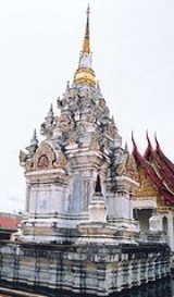
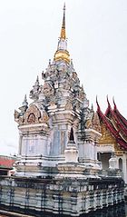
kingdom of the 5th to 13th century - some historians even claim that it was the capital for the kingdom for some time, but this is largely disputed. The temple Wat Phra Borom That is centered around a reconstructed stupa
in Srivijaya style. The nearby branch of the National Museum
has several relicts of that time on display. Two more former stupas nearby are now only brick mounds.
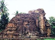
Inscription 23, as it was labeled by Prince Damrong
in his Collected Inscriptions of Siam, is now attributed to Wat Hua Wiang in Chaiya. Dated to the year 697 of the Mahasakkarat era (i.e. 775 CE), the inscription on a Bai Sema
shaped stone tells about the King of Srivijaya having erected three stupas at that site that possibly the one at Wat Phra Borom That. But also be assumed as three stupas at Wat Hua Wiang (Hua Wiang temple), Wat Lhong (Lhong temple) and Wat Kaew (Kaew temple) found in the area of Chaiya ancient city, stand in the direction from north to south on the old sand dune.
Another important temple near Chaiya is the Wat Suan Mohkha Phalaram (also known by the short name Suan Mok, or Wat Than Nam Lai Monastery of Flowing Water), a forest temple. The temple was founded in 1932 by Phra Buddhadasa
(1906-1993), a highly revered Buddhist teacher. In 1959 the temple was relocated to the present 150 acre
(0.6 km²) site. These temples were believed to be used to store rice in large quantities, this was due to the invading Japanese
at that time. These large Buddhist Rice temples are vary rare in the region and only one has be officially labeled as a rice storage tempels.
is the main railway station of the district; the Asian highway AH2
(Thailand Route 41
) also passes the city.
). These are further subdivided into 54 villages (muban
). There are two townships (thesaban tambon) - Talad Chaiya
covers most of tambon Talad Chaiya and parts of Lamet; Phumriang the whole tambon Phumriang.
Amphoe
An amphoe is the second level administrative subdivision of Thailand. Usually translated as district, amphoe make up the provinces, and are analogous to a county seat...
) and town in Surat Thani Province
Surat Thani Province
Surat Thani is the largest of the southern provinces of Thailand, on the eastern shore of the Gulf of Thailand. Surat Thani means City of Good People, the title given to the city by King Vajiravudh ....
in southern Thailand
Thailand
Thailand , officially the Kingdom of Thailand , formerly known as Siam , is a country located at the centre of the Indochina peninsula and Southeast Asia. It is bordered to the north by Burma and Laos, to the east by Laos and Cambodia, to the south by the Gulf of Thailand and Malaysia, and to the...
. The town itself has a population of 13,133 (5,549 in Talad Chaiya
Talad Chaiya Town
Talat Chaiya is the one of two subdistrict municipalities in the Chaiya district, Surat Thani Province, southern Thailand. It was founded as the center of Chaiya district in 1915 on the area of former Srivijaya city of Chaiya...
and 7,582 in Phumriang) (2006), while the whole district has a population of 47,750.
Geography
Neighboring districts are (from the south clockwise) Tha ChangAmphoe Tha Chang, Surat Thani Province
Tha Chang is a district in the west of Surat Thani Province of southern Thailand.Neighboring districts are Chaiya to the north, the Bandon Bay to the east, Phunphin, Vibhavadi and Ban Ta Khun to the south, and to the west the district Kapoe of Ranong Province.-History:The minor district was...
, Kapoe
Amphoe Kapoe
Kapoe is a district of Ranong Province, southern Thailand.-Geography:Neighboring districts are Mueang Ranong of Ranong Province, Phato of Chumphon Province, Chaiya, Tha Chang and Ban Ta Khun of Surat Thani Province, and Suk Samran of Ranong again...
(Ranong Province
Ranong Province
Ranong is one of the southern provinces of Thailand, on the coast of the Andaman Sea. It is the province with the fewest citizens. Neighboring provinces are Chumphon, Surat Thani and Phang Nga...
), Phato
Amphoe Phato
-History:Originally Patho was a district of Mueang Lang Suan, which was abolished and included into Chumphon province in 1932. In 1938 Phato was reduced to a minor district...
(Chumphon Province
Chumphon Province
Chumphon ) is one of the southern provinces of Thailand, at the shore of the Gulf of Thailand. Neighboring provinces are Prachuap Khiri Khan, Surat Thani and Ranong...
), and Tha Chana
Amphoe Tha Chana
Tha Chana is a district in the north of Surat Thani Province of southern Thailand.-History:The district is already quite old. Originally named Prasong , it was a subordinate of Mueang Lang Suan. In 1906 it was reassigned to Mueang Chaiya, which is now Surat Thani province. The seat of the...
. To the east is the Gulf of Thailand
Gulf of Thailand
The Gulf of Thailand , also known in to Malays as Teluk Siam literally meant Gulf of Siam, is a shallow arm of the South China Sea.-Geography:...
, with the cape Sui marking the northern end of the Bandon Bay
Bandon Bay
Bandon Bay is a bay in the Gulf of Thailand in the Surat Thani Province, extending from the Sui cape in Chaiya district in the northwest to the Kanchanadit district to the east. The total coastline is about 100 km. The bay is dominated by the estuary of the rivers Tapi and Phum Duang...
.
The eastern part of the district consists of mostly flat low coastal areas, while to the west are the mountains of the Phuket mountain range
Phuket mountain range
The Phuket mountain range is a mountain range in the Kra Isthmus, Thailand.-Geography:This chain of hills is one of the southern sections of the central cordillera, the mountain chain which runs from Tibet through all of the Malay peninsula....
, including the Kaeng Krung National Park
Kaeng Krung National Park
Kaeng Krung is a national park in southern Thailand, protecting 541 km² of forests within the Phuket mountain range. It has been declared a national park on December 4, 1990....
.
History
Srivijaya
Srivijaya was a powerful ancient thalassocratic Malay empire based on the island of Sumatra, modern day Indonesia, which influenced much of Southeast Asia. The earliest solid proof of its existence dates from the 7th century; a Chinese monk, I-Tsing, wrote that he visited Srivijaya in 671 for 6...
kingdom of the 5th to 13th century - some historians even claim that it was the capital for the kingdom for some time, but this is largely disputed. The temple Wat Phra Borom That is centered around a reconstructed stupa
Stupa
A stupa is a mound-like structure containing Buddhist relics, typically the remains of Buddha, used by Buddhists as a place of worship....
in Srivijaya style. The nearby branch of the National Museum
National Museum (Thailand)
The National Museum in Thailand is the main museum on the history of the Thai culture. The main museum is located in Bangkok on Na Phrathat Road next to the Sanam Luang, not far from Wat Phra Kaew....
has several relicts of that time on display. Two more former stupas nearby are now only brick mounds.
Inscription 23, as it was labeled by Prince Damrong
Damrong Rajanubhab
Ditsawarakuman Damrong Rajanubhab was the founder of the modern Thai education system as well as the modern provincial administration...
in his Collected Inscriptions of Siam, is now attributed to Wat Hua Wiang in Chaiya. Dated to the year 697 of the Mahasakkarat era (i.e. 775 CE), the inscription on a Bai Sema
Bai Sema
Bai Sema are the boundary stones which designate the sacred area for a phra ubosot within a Thai Buddhist temple .-History:...
shaped stone tells about the King of Srivijaya having erected three stupas at that site that possibly the one at Wat Phra Borom That. But also be assumed as three stupas at Wat Hua Wiang (Hua Wiang temple), Wat Lhong (Lhong temple) and Wat Kaew (Kaew temple) found in the area of Chaiya ancient city, stand in the direction from north to south on the old sand dune.
Another important temple near Chaiya is the Wat Suan Mohkha Phalaram (also known by the short name Suan Mok, or Wat Than Nam Lai Monastery of Flowing Water), a forest temple. The temple was founded in 1932 by Phra Buddhadasa
Buddhadasa
Buddhadasa Bhikkhu was a famous and influential ascetic-philosopher of the 20th century. Known as an innovative reinterpreter of Buddhist doctrine and Thai folk beliefs, Buddhadasa fostered a reformation in conventional religious perceptions in his home country, Thailand, as well as abroad...
(1906-1993), a highly revered Buddhist teacher. In 1959 the temple was relocated to the present 150 acre
Acre
The acre is a unit of area in a number of different systems, including the imperial and U.S. customary systems. The most commonly used acres today are the international acre and, in the United States, the survey acre. The most common use of the acre is to measure tracts of land.The acre is related...
(0.6 km²) site. These temples were believed to be used to store rice in large quantities, this was due to the invading Japanese
Empire of Japan
The Empire of Japan is the name of the state of Japan that existed from the Meiji Restoration on 3 January 1868 to the enactment of the post-World War II Constitution of...
at that time. These large Buddhist Rice temples are vary rare in the region and only one has be officially labeled as a rice storage tempels.
Traffic
Chaiya is on the southern railway line, Chaiya Railway StationChaiya Railway Station
Chaiya Railway Station is the main railway station in the northern Surat Thani Province, Thailand. It located on S.R.T. Southern Railway Line km 597+751 in Talad Chaiya Town, Chaiya District...
is the main railway station of the district; the Asian highway AH2
AH2
The AH2 is a road in the Asian Highway Network running 8230 miles from Denpasar, Indonesia to Khosravi, Iran. The route is as follows:-Indonesia:Denpasar — Surabaya — Surakarta — Semarang — Cikampek — Jakarta...
(Thailand Route 41
Thailand Route 41
Route 41 starts at intersection with Route 4 in Chumphon Province. It goes southward passing through Surat Thani Province and Nakhon Si Thammarat Province. It ends at Phatthalung Province joining Route 4 again.-Route Details:...
) also passes the city.
Administration
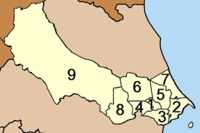
The district Chaiya is subdivided into 9 subdistricts (tambonTambon
Tambon is a local government unit in Thailand. Below district and province , they form the third administrative subdivision level. As of the 2009 there are 7255 tambon, not including the 169 khwaeng of Bangkok, which are set at the same administrative level, thus every district contains 8-10 tambon...
). These are further subdivided into 54 villages (muban
Muban
Muban is the lowest administrative subdivision of Thailand. Usually translated as village, they are the subdivision of tambon. As of 2008, there are 74944 administrative villages in Thailand. As of the 1990 census, the average village consisted of 144 households or 746 persons.A muban does not...
). There are two townships (thesaban tambon) - Talad Chaiya
Talad Chaiya Town
Talat Chaiya is the one of two subdistrict municipalities in the Chaiya district, Surat Thani Province, southern Thailand. It was founded as the center of Chaiya district in 1915 on the area of former Srivijaya city of Chaiya...
covers most of tambon Talad Chaiya and parts of Lamet; Phumriang the whole tambon Phumriang.
| No. | Name | Thai name | Villages | Inh. Population A population is all the organisms that both belong to the same group or species and live in the same geographical area. The area that is used to define a sexual population is such that inter-breeding is possible between any pair within the area and more probable than cross-breeding with individuals... |
||||||
|---|---|---|---|---|---|---|---|---|---|---|
| 1. | Talat Chaiya | ตลาดไชยา | 5 | 5,549 | 6. | Pa We | ป่าเว | 6 | 4,887 | |
| 2. | Phumriang | พุมเรียง | 5 | 7,582 | 7. | Takrop | ตะกรบ | 5 | 3,649 | |
| 3. | Lamet | เลม็ด | 7 | 4,582 | 8. | Mo Thai | โมถ่าย | 6 | 4,215 | |
| 4. | Wiang | เวียง | 5 | 3,365 | 9. | Pak Mak | ปากหมาก | 7 | 8,975 | |
| 5. | Thung | ทุ่ง | 8 | 4,946 |