

Central Avenue, Phoenix, Arizona
Encyclopedia
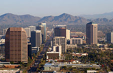
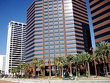
The Central Avenue Corridor is a significant stretch of north-south Central Avenue, in Phoenix, Arizona
. Roughly bounded by Camelback Road to its north, and McDowell Road to its south, this is one of Phoenix's most vital and heavily trafficked stretches of roadway. It is also one of the region's largest centers of employment, with nearly 60,000 people being employed within just a three-mile (5 km) radius of this swath of Central Avenue. Major employers here include major banks and financial institutions, hi-tech companies, and several major law firms and government agencies.
This corridor bisects a larger area known as Midtown, Phoenix—the collection of neighborhoods north of Downtown, and south of the North-Central and Sunnyslope areas. Block numbers or addresses for Central Avenue landmarks are indicated in parentheses where available.
 Located halfway between the major arterial road
s 7th Street and 7th Avenue, Central Avenue is the dividing line for Phoenix as well as other Maricopa County cities that do not have their own addressing system.
Central Avenue crosses every economic stratum in Phoenix, rather abruptly in places. Downtown Phoenix land values are on par with other major cities despite the generally perceived lack of vitality. North of Midtown and Uptown Phoenix, the large old homes in the tony North Central neighborhoods hark back to lower North Central Avenue's past. On the other side of the canal from North Central, at Central Avenue's dead-end, is the Sunnyslope District, founded in 1907. South of downtown, approaching South Mountain, the South Central area contains some of the most blighted neighborhoods in the city.
Central Avenue represents almost every architectural use and style found in Phoenix. Dilapidated and thriving strip centers, small old brick warehouses, industrial and commercial properties, single family homes and estates, and many of the city's high-rises all have Central Avenue addresses. On Central or in the immediate vicinity lie officially recognized and protected historic neighborhoods and a variety of cultural, performance, and sporting venues.
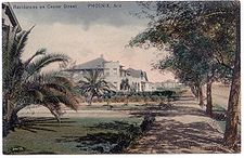 Central Avenue was originally named Center Street upon Phoenix's founding with the surrounding north-south roads named after Indian tribes
. The original Churchill Addition of 1877, covering a small area north of Van Buren Street to what is presently Roosevelt Street, was the first recorded plat
showing Central Avenue with its present name. Despite this, there is evidence of it being called Center Street into the 1930s. A replat of Phoenix's original townsite in 1895 was the first to officially show numbered streets and avenues starting from the east and west sides of Central.
Phoenix's first school was built on Center Street and Monroe in 1874 as a one-room adobe
. A new four-room schoolhouse replaced it in 1879 as the fourth brick
building in the city, and the school was expanded again in 1893. By 1919, the school had deteroriated considerably and was condemned and sold. The luxurious Hotel San Carlos, the first downtown hotel to feature air conditioning
and elevator
s, opened on that spot in 1928 after a long delay. The Phoenix Indian School
was established in 1891 giving Indian School Road (4100 N) its namesake. Near North Mountain, architect William Robert Norton subdivided the first parts of Sunnyslope in 1911 amidst a "squatters' community of asthmatics and tuberculosis
patients" whose makeshift dwellings were illegal in the city proper.
 By 1917, a mile-long bridge was open over the immense Salt River
ultimately connecting downtown with South Mountain
, the latter known as the Salt River Mountain at the time. The Westward Ho
was constructed in 1927 and would remain the city's tallest building until 1960. Brophy College Preparatory
(4701 N) opened for the first time in 1928 amidst agricultural fields. The Heard Museum
(2301 N) opened in 1929 with little fanfare but would grow to be a highly respected institution of Native American
culture and history.
north, developers found plenty of available land on Central Avenue and began capitalizing on the cachet of the youthful city's signature boulevard. Local steakhouse legend Durant's (1211 N) opened in 1950 and has changed little other than that patrons today enter the restaurant through the back off the parking lot as celebrities and other socialites once did back then. Park Central Mall
(3110 N) replaced a dairy farm in the middle part of the decade, signaling the beginning of downtown
's long decline with new ring suburban retail. America's second McDonald's
restaurant was built near Indian School Road in 1953. It was the first McDonald's franchise, the first to feature the Golden Arches
, and served as a model for Ray Kroc
's Illinois store. These early commercial developments foreshadow the trend towards autocentrism on Central Avenue and indeed the rest of the city. The first major high-rise built on Central Avenue outside of downtown was the Phoenix Towers (2201 N), erected in 1957. The Phoenix Art Museum
moved to Central Avenue in 1959. Phoenix fully annexed Sunnyslope, at Central's north terminus, that year. Central Avenue to its southern terminus, South Mountain, where minorities had been historically redlined
, was annexed a year later.
 The 1960s brought a wave of high-rise development in Phoenix to Central Avenue that the city had hardly seen in its modern history. In 1960 the Phoenix Corporate Center
opened, which at 341 feet (103.9 m) became the tallest building in Arizona. The first phase of the Rozenweig Center, known today as Phoenix City Square
, was completed in 1964. Architect Wenceslaus Sarmiento
's largest project, the landmark Phoenix Financial Center
(3443 N, better known by locals as the "Punch-card Building" in recognition of its unique southeastern facade
) was also first finished in 1964 for banker and developer David Murdoch. Eight floors were added four years later. In addition to a number of other office towers, most of Phoenix's residential high-rises, such as the Landmark on Central (4750 N, then known as Camelback Towers), Executive Towers (207 W. Clarendon) and the Regency Apartments (2323 N) were built during this decade.
 In 1971, Phoenix cemented the precedent of previous ad-hoc zoning decisions with the adoption of the Central Phoenix Plan, which envisioned unlimited building heights along Central Avenue. The new plan, however, did not sustain long-term development of the "Central Corridor." Only a few office towers were constructed along North Central during this decade and none approached the scope of projects constructed during the previous decade. Instead, downtown resurged in popularity during the 1970s, witnessing a flurry of construction activity not seen again until the urban real estate boom of the 2000s. In 1979, Phoenix adopted the Phoenix Concept 2000 plan which split the city into urban villages--each with its own village core where greater height and density is permitted, further shaping the free-market development culture. Phoenix officially turned from its roots as a city built around its two main drag
s to a city of many nodes later connected by freeways. The cluster of high-rises north of Thomas Road became part of the Encanto
village core.
with a second wave of office towers. One Camelback was built in 1985 at the intersection of Central and one of Phoenix's other signature streets, Camelback Road. It is likely the last structure that will be built that tall that far north, thus endcapping the built-out potential of the Central Avenue skyline almost five miles (8 km) from its origin downtown. The Phoenix Indian School was closed in 1988 and would remain vacant for years. The city's current third-tallest building at 397 feet (121 m), Qwest Tower, opened in Phoenix Plaza
in 1989 on Thomas Road (2900 N).
 Phoenix adopted the Arts District plan in 1992 in an attempt to connect lower Midtown's cultural amenities together in a walkable area, but the private development that the plan anticipated never arrived, though Burton Barr Central Library
(1221 N) opened in 1995. The savings-and-loan boom that birthed new towers for Midtown Phoenix plagued it throughout the economic doldrums of the 1990s. The city's current fifth-tallest at 374 feet (114 m), the Viad Tower
(1850 N) opened in 1991 as the Dial Tower, an isolate between the Downtown and Midtown skylines and would be the last new tower constructed for Midtown Phoenix. Floorplates of office towers built in previous decades had become functionally obsolete and contributed heavily toward Midtown's high vacancy rates. Even despite the recession, the swank Biltmore area surrounding 24th Street and Camelback Road began to eclipse the Central Corridor as the Phoenix metropolitan area
's premiere office destination with mid- and low-rise developments such as the Camelback Esplanade. But as the 1990s were unkind to Central Phoenix's oldest parts, a renewed interest in the central city was taking form, this time focused on new residences instead of offices.
to build the METRO Light Rail
line. The 20 miles (32.2 km) initial phase, which opened for service in late December 2008, begins at Christown Spectrum Mall
, to Camelback, down Central, and then down Washington Street en route to Tempe
and Mesa
. On Central Avenue, there are seven stops in Midtown http://www.PhoenixCentral.org and Uptown Phoenix and three in downtown. The three year construction process commenced in late 2005, with the final rail being laid in late April, 2008. Many businesses experienced challenges during construction, but most have persevered—some through an assistance program sponsored by Valley Metro and the City.
 The alignment of light rail down the center of Central is the most significant event in the street's history. It reformed its future growth as Phoenix adopted transit oriented development zoning standards in 2003 within 1/2 mile of stops, effectively making the autocentric developments that had come to define Central Avenue a thing of the past. In Midtown, the market responded with two mid-rise projects, the Artisan Lofts (1326 N), which opened in 2004 and the Tapestry on Central (2302 N), which opened in 2007. Tapestry is also notable as its construction brought down
the last of the estate homes on that stretch of Central. Capitalizing on its retro
mid-1960s styling, Camelback Towers became the Landmark on Central in 2004, continuing a tradition of the city's few apartment
towers becoming ownership condominiums later on. Also that year, Century Plaza
(3225 N), originally built in 1974 as offices, began a complete exterior and interior remodel as part of its conversion to condominiums. As reconstruction continued, two additional floors were started in 2007. Century plaza is now known as "One Lexington".
Steele Indian School Park
opened in November 2001 on the site of the old Phoenix Indian School five years after an intricate three-way land exchange involving the Barron Collier Company and the federal government
. In Phoenix, Collier received a 15 acres (60,702.9 m²) portion on the southwest corner of the site for long-term investment in addition to the Downtown block on which the Collier Center was built.
Phoenix, Arizona
Phoenix is the capital, and largest city, of the U.S. state of Arizona, as well as the sixth most populated city in the United States. Phoenix is home to 1,445,632 people according to the official 2010 U.S. Census Bureau data...
. Roughly bounded by Camelback Road to its north, and McDowell Road to its south, this is one of Phoenix's most vital and heavily trafficked stretches of roadway. It is also one of the region's largest centers of employment, with nearly 60,000 people being employed within just a three-mile (5 km) radius of this swath of Central Avenue. Major employers here include major banks and financial institutions, hi-tech companies, and several major law firms and government agencies.
This corridor bisects a larger area known as Midtown, Phoenix—the collection of neighborhoods north of Downtown, and south of the North-Central and Sunnyslope areas. Block numbers or addresses for Central Avenue landmarks are indicated in parentheses where available.
Central Avenue Corridor today
Arterial road
An arterial road, or arterial thoroughfare, is a high-capacity urban road. The primary function of an arterial road is to deliver traffic from collector roads to freeways, and between urban centres at the highest level of service possible. As such, many arteries are limited-access roads, or feature...
s 7th Street and 7th Avenue, Central Avenue is the dividing line for Phoenix as well as other Maricopa County cities that do not have their own addressing system.
Central Avenue crosses every economic stratum in Phoenix, rather abruptly in places. Downtown Phoenix land values are on par with other major cities despite the generally perceived lack of vitality. North of Midtown and Uptown Phoenix, the large old homes in the tony North Central neighborhoods hark back to lower North Central Avenue's past. On the other side of the canal from North Central, at Central Avenue's dead-end, is the Sunnyslope District, founded in 1907. South of downtown, approaching South Mountain, the South Central area contains some of the most blighted neighborhoods in the city.
Central Avenue represents almost every architectural use and style found in Phoenix. Dilapidated and thriving strip centers, small old brick warehouses, industrial and commercial properties, single family homes and estates, and many of the city's high-rises all have Central Avenue addresses. On Central or in the immediate vicinity lie officially recognized and protected historic neighborhoods and a variety of cultural, performance, and sporting venues.
Pre–World War II
Indian tribes
The India's tribal belts refer to contiguous areas of indigenous settlement of tribal people of India.-Northwest India:The Tribal Belt of Northwest India includes the states of Rajasthan, Gujarat, Maharashtra, and Karnataka. The tribal people of this region have origins which precede the Vedic...
. The original Churchill Addition of 1877, covering a small area north of Van Buren Street to what is presently Roosevelt Street, was the first recorded plat
Plat
A plat in the U.S. is a map, drawn to scale, showing the divisions of a piece of land. Other English-speaking countries generally call such documents a cadastral map or plan....
showing Central Avenue with its present name. Despite this, there is evidence of it being called Center Street into the 1930s. A replat of Phoenix's original townsite in 1895 was the first to officially show numbered streets and avenues starting from the east and west sides of Central.
Phoenix's first school was built on Center Street and Monroe in 1874 as a one-room adobe
Adobe
Adobe is a natural building material made from sand, clay, water, and some kind of fibrous or organic material , which the builders shape into bricks using frames and dry in the sun. Adobe buildings are similar to cob and mudbrick buildings. Adobe structures are extremely durable, and account for...
. A new four-room schoolhouse replaced it in 1879 as the fourth brick
Brick
A brick is a block of ceramic material used in masonry construction, usually laid using various kinds of mortar. It has been regarded as one of the longest lasting and strongest building materials used throughout history.-History:...
building in the city, and the school was expanded again in 1893. By 1919, the school had deteroriated considerably and was condemned and sold. The luxurious Hotel San Carlos, the first downtown hotel to feature air conditioning
Air conditioning
An air conditioner is a home appliance, system, or mechanism designed to dehumidify and extract heat from an area. The cooling is done using a simple refrigeration cycle...
and elevator
Elevator
An elevator is a type of vertical transport equipment that efficiently moves people or goods between floors of a building, vessel or other structures...
s, opened on that spot in 1928 after a long delay. The Phoenix Indian School
Phoenix Indian School
The Phoenix Indian School, or Phoenix Indian High School in its later years, was a Bureau of Indian Affairs-operated school in the heart of Phoenix, Arizona. It was mostly a high school, but it served lower grades from 1891 to 1935. It opened in 1891 and closed in 1990 at the orders of the federal...
was established in 1891 giving Indian School Road (4100 N) its namesake. Near North Mountain, architect William Robert Norton subdivided the first parts of Sunnyslope in 1911 amidst a "squatters' community of asthmatics and tuberculosis
Tuberculosis
Tuberculosis, MTB, or TB is a common, and in many cases lethal, infectious disease caused by various strains of mycobacteria, usually Mycobacterium tuberculosis. Tuberculosis usually attacks the lungs but can also affect other parts of the body...
patients" whose makeshift dwellings were illegal in the city proper.
Salt River (Arizona)
The Salt River is a stream in the U.S. state of Arizona. It is the largest tributary of the Gila River. The river is about long. Its drainage basin is about large. The longest of the Salt River's many tributaries is the Verde River...
ultimately connecting downtown with South Mountain
South Mountain Park
South Mountain Park in Phoenix, Arizona, is the largest city park in the United States, one of the largest urban parks in North America and in the world. It has been designated as a Phoenix Point of Pride.-Geography and Ecology:...
, the latter known as the Salt River Mountain at the time. The Westward Ho
Westward Ho (Phoenix)
Westward Ho is a skyscraper located at 618 North Central Avenue in Phoenix, Arizona, formerly occupied by a hotel of the same name. When completed in 1928, the 208-foot hotel was the tallest building in Arizona, a title it held until 1960....
was constructed in 1927 and would remain the city's tallest building until 1960. Brophy College Preparatory
Brophy College Preparatory
Brophy College Preparatory is a Jesuit high school located in Phoenix, Arizona. The school is currently limited to all-male enrollment of approximately 1,200 students. It is operated independently of the Roman Catholic Diocese of Phoenix...
(4701 N) opened for the first time in 1928 amidst agricultural fields. The Heard Museum
Heard Museum
The Heard Museum of Native Cultures and Art is a museum located in Phoenix, Arizona, USA. There is also the Heard Museum North Scottsdale branch in Scottsdale and the Heard Museum West branch in Surprise....
(2301 N) opened in 1929 with little fanfare but would grow to be a highly respected institution of Native American
Native Americans in the United States
Native Americans in the United States are the indigenous peoples in North America within the boundaries of the present-day continental United States, parts of Alaska, and the island state of Hawaii. They are composed of numerous, distinct tribes, states, and ethnic groups, many of which survive as...
culture and history.
1950s
As Phoenix sprawledUrban sprawl
Urban sprawl, also known as suburban sprawl, is a multifaceted concept, which includes the spreading outwards of a city and its suburbs to its outskirts to low-density and auto-dependent development on rural land, high segregation of uses Urban sprawl, also known as suburban sprawl, is a...
north, developers found plenty of available land on Central Avenue and began capitalizing on the cachet of the youthful city's signature boulevard. Local steakhouse legend Durant's (1211 N) opened in 1950 and has changed little other than that patrons today enter the restaurant through the back off the parking lot as celebrities and other socialites once did back then. Park Central Mall
Park Central Mall
Park Central Mall was the first shopping mall in Phoenix, Arizona, located on Central Avenue and Osborn Road. Today it exists as a mixed use business park primarily occupied by regional administrative offices for Catholic Healthcare West, and regional offices for UnitedHealth Group...
(3110 N) replaced a dairy farm in the middle part of the decade, signaling the beginning of downtown
Downtown Phoenix
Downtown Phoenix is the central business district of Phoenix, Arizona, United States. It is located near the geographic center of the Phoenix metropolitan area or Valley of the Sun. Phoenix, being the county seat of Maricopa County and the capital of Arizona, serves as the center of politics,...
's long decline with new ring suburban retail. America's second McDonald's
McDonald's
McDonald's Corporation is the world's largest chain of hamburger fast food restaurants, serving around 64 million customers daily in 119 countries. Headquartered in the United States, the company began in 1940 as a barbecue restaurant operated by the eponymous Richard and Maurice McDonald; in 1948...
restaurant was built near Indian School Road in 1953. It was the first McDonald's franchise, the first to feature the Golden Arches
Golden Arches
The Golden Arches are the symbol of McDonald's, the global fast-food hamburger chain. Originally, real arches were part of the restaurant design...
, and served as a model for Ray Kroc
Ray Kroc
Raymond Albert "Ray" Kroc was an American fast food businessman who joined McDonald's in 1954 and built it into the most successful fast food operation in the world. Kroc was included in Time 100: The Most Important People of the Century, and amassed a fortune during his lifetime...
's Illinois store. These early commercial developments foreshadow the trend towards autocentrism on Central Avenue and indeed the rest of the city. The first major high-rise built on Central Avenue outside of downtown was the Phoenix Towers (2201 N), erected in 1957. The Phoenix Art Museum
Phoenix art museum
The Phoenix Art Museum is the Southwest United States' largest art museum for visual art. Located in Phoenix, Arizona, the museum is . It displays international exhibitions alongside its comprehensive collection of more than 18,000 works of American, Asian, European, Latin American, Western...
moved to Central Avenue in 1959. Phoenix fully annexed Sunnyslope, at Central's north terminus, that year. Central Avenue to its southern terminus, South Mountain, where minorities had been historically redlined
Redlining
Redlining is the practice of denying, or increasing the cost of services such as banking, insurance, access to jobs, access to health care, or even supermarkets to residents in certain, often racially determined, areas. The term "redlining" was coined in the late 1960s by John McKnight, a...
, was annexed a year later.
1960s
Phoenix Corporate Center
The Phoenix Corporate Center is a 26 floor skyscraper in Phoenix, Arizona. It was built in 1960 and designed in the International Style. The tower was built two miles north of Downtown Phoenix in the Central Corridor. At that time corporate investment turned its attention away from downtown...
opened, which at 341 feet (103.9 m) became the tallest building in Arizona. The first phase of the Rozenweig Center, known today as Phoenix City Square
Phoenix City Square
3800 Tower3800 is the smallest of the office towers in City Square, coming in under . Originally designed in the International Style, 3800 was updated in the early 1990s with cleaner lines, more architectural detail and given a pyramid crown. It contains an attached day care, and it is located...
, was completed in 1964. Architect Wenceslaus Sarmiento
Wenceslaus Sarmiento
Wenceslaus Sarmiento, also known as W.A. Sarmiento is a Peruvian-born American modernist architect.Sarmiento studied in various locations in South America, for eighteen months in the office of Oscar Niemeyer, before coming to the United States...
's largest project, the landmark Phoenix Financial Center
Phoenix Financial Center
The Phoenix Financial Center is a high-rise office building located along Central Avenue in the Midtown district of Phoenix, Arizona, United States. It was built in 1968 by the Financial Corporation of Arizona. At the time, the main tower consisted only of 11 stories; the extra eight were added in...
(3443 N, better known by locals as the "Punch-card Building" in recognition of its unique southeastern facade
Facade
A facade or façade is generally one exterior side of a building, usually, but not always, the front. The word comes from the French language, literally meaning "frontage" or "face"....
) was also first finished in 1964 for banker and developer David Murdoch. Eight floors were added four years later. In addition to a number of other office towers, most of Phoenix's residential high-rises, such as the Landmark on Central (4750 N, then known as Camelback Towers), Executive Towers (207 W. Clarendon) and the Regency Apartments (2323 N) were built during this decade.
1970s
Main Street
Main Street is the metonym for a generic street name of the primary retail street of a village, town, or small city in many parts of the world...
s to a city of many nodes later connected by freeways. The cluster of high-rises north of Thomas Road became part of the Encanto
Encanto, Phoenix, Arizona
The Encanto Village is one of the 15 villages that make up Phoenix, Arizona. It is located in Central Phoenix. The western border of the village is the I-17 Black Canyon Freeway, and the southern border is McDowell Road. The Grand Canal makes up the northern and eastern border.The core of the...
village core.
1980s
Development on North Central Avenue began anew in the 1980s as part of that decade's real estate boomSavings and Loan crisis
The savings and loan crisis of the 1980s and 1990s was the failure of about 747 out of the 3,234 savings and loan associations in the United States...
with a second wave of office towers. One Camelback was built in 1985 at the intersection of Central and one of Phoenix's other signature streets, Camelback Road. It is likely the last structure that will be built that tall that far north, thus endcapping the built-out potential of the Central Avenue skyline almost five miles (8 km) from its origin downtown. The Phoenix Indian School was closed in 1988 and would remain vacant for years. The city's current third-tallest building at 397 feet (121 m), Qwest Tower, opened in Phoenix Plaza
Phoenix Plaza
Phoenix Plaza is a mixed use office complex located in midtown Phoenix, Arizona. It was built between 1988 and 1990 at a cost of $158 million USD. There is of office space plus 225 hotel rooms. Phoenix Plaza has three hi-rise office buildings, a large parking garage and a hotel tower. Two distinct...
in 1989 on Thomas Road (2900 N).
1990s
Burton Barr Central Library
The Burton Barr Central Library is the central library in Phoenix, Arizona. It is the flagship location and administrative headquarters for the Phoenix Public Library....
(1221 N) opened in 1995. The savings-and-loan boom that birthed new towers for Midtown Phoenix plagued it throughout the economic doldrums of the 1990s. The city's current fifth-tallest at 374 feet (114 m), the Viad Tower
Viad Tower
The Viad Tower is a highrise in Midtown Phoenix, Arizona also known as the Viad Corporate Center and formerly the Dial Tower. The tower was constructed in 1991 for the Dial company, which is why the building resembles a Dial soap bar. It rises 374 feet , topping out at 24 floors.It was designed in...
(1850 N) opened in 1991 as the Dial Tower, an isolate between the Downtown and Midtown skylines and would be the last new tower constructed for Midtown Phoenix. Floorplates of office towers built in previous decades had become functionally obsolete and contributed heavily toward Midtown's high vacancy rates. Even despite the recession, the swank Biltmore area surrounding 24th Street and Camelback Road began to eclipse the Central Corridor as the Phoenix metropolitan area
Phoenix Metropolitan Area
The Phoenix metropolitan area, often referred to as The Valley of the Sun, is a metropolitan area, centered on the city of Phoenix, that includes much of the central part of the US state of Arizona...
's premiere office destination with mid- and low-rise developments such as the Camelback Esplanade. But as the 1990s were unkind to Central Phoenix's oldest parts, a renewed interest in the central city was taking form, this time focused on new residences instead of offices.
2000s
After numerous failed initiatives, Phoenix voters finally approved the Transit 2000 Regional Transportation Plan which dedicates a percentage of funds raised through a 4/10-cent (four cents on ten dollars) sales taxSales tax
A sales tax is a tax, usually paid by the consumer at the point of purchase, itemized separately from the base price, for certain goods and services. The tax amount is usually calculated by applying a percentage rate to the taxable price of a sale....
to build the METRO Light Rail
METRO Light Rail (Phoenix)
Metro Light Rail is a 32 km light rail line operating in the U.S. state of Arizona. Part of the Valley Metro public transit system, it serves the cities of Phoenix, Tempe, and Mesa. Construction began in March 2005; operation started December 27, 2008...
line. The 20 miles (32.2 km) initial phase, which opened for service in late December 2008, begins at Christown Spectrum Mall
Phoenix Christown Mall (Valley Metro Rail station)
The Montebello Avenue and 19th Avenue station, immediately south of the well-known major arterial Bethany Home Road, is also known as Phoenix Christown Spectrum Mall Station and is the western terminus station on the METRO light rail line in Phoenix, Arizona, USA...
, to Camelback, down Central, and then down Washington Street en route to Tempe
Tempe, Arizona
Tempe is a city in Maricopa County, Arizona, USA, with the Census Bureau reporting a 2010 population of 161,719. The city is named after the Vale of Tempe in Greece. Tempe is located in the East Valley section of metropolitan Phoenix; it is bordered by Phoenix and Guadalupe on the west, Scottsdale...
and Mesa
Mesa, Arizona
According to the 2010 Census, the racial composition of Mesa was as follows:* White: 77.1% * Hispanic or Latino : 26.54%* Black or African American: 3.5%* Two or more races: 3.4%* Native American: 2.4%...
. On Central Avenue, there are seven stops in Midtown http://www.PhoenixCentral.org and Uptown Phoenix and three in downtown. The three year construction process commenced in late 2005, with the final rail being laid in late April, 2008. Many businesses experienced challenges during construction, but most have persevered—some through an assistance program sponsored by Valley Metro and the City.
Demolition
Demolition is the tearing-down of buildings and other structures, the opposite of construction. Demolition contrasts with deconstruction, which involves taking a building apart while carefully preserving valuable elements for re-use....
the last of the estate homes on that stretch of Central. Capitalizing on its retro
Retro
Retro is a culturally outdated or aged style, trend, mode, or fashion, from the overall postmodern past, that has since that time become functionally or superficially the norm once again. The use of "retro" style iconography and imagery interjected into post-modern art, advertising, mass media, etc...
mid-1960s styling, Camelback Towers became the Landmark on Central in 2004, continuing a tradition of the city's few apartment
Apartment
An apartment or flat is a self-contained housing unit that occupies only part of a building...
towers becoming ownership condominiums later on. Also that year, Century Plaza
Century Plaza
Century Plaza was an enclosed shopping mall in Birmingham, Alabama, USA. Opened in 1975, the mall originally included four anchor stores and more than one hundred tenants, but lost three of those anchors in the mid-2000s. In May 2009, the mall was completely closed as Sears and the rest of the...
(3225 N), originally built in 1974 as offices, began a complete exterior and interior remodel as part of its conversion to condominiums. As reconstruction continued, two additional floors were started in 2007. Century plaza is now known as "One Lexington".
Steele Indian School Park
Steele Indian School Park
Steele Indian School Park is located on the northeast corner of Indian School Road and Central Avenue in Phoenix, Arizona.The park is on the site of the Phoenix Indian School, one of several boarding schools owned and operated by the U.S. government, designed in the late 19th century to socialize...
opened in November 2001 on the site of the old Phoenix Indian School five years after an intricate three-way land exchange involving the Barron Collier Company and the federal government
Federal government of the United States
The federal government of the United States is the national government of the constitutional republic of fifty states that is the United States of America. The federal government comprises three distinct branches of government: a legislative, an executive and a judiciary. These branches and...
. In Phoenix, Collier received a 15 acres (60,702.9 m²) portion on the southwest corner of the site for long-term investment in addition to the Downtown block on which the Collier Center was built.