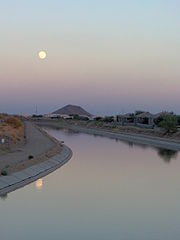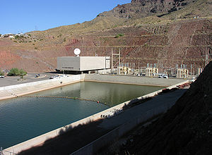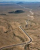
Central Arizona Project Aqueduct
Encyclopedia

Aqueduct
An aqueduct is a water supply or navigable channel constructed to convey water. In modern engineering, the term is used for any system of pipes, ditches, canals, tunnels, and other structures used for this purpose....
in Arizona
Arizona
Arizona ; is a state located in the southwestern region of the United States. It is also part of the western United States and the mountain west. The capital and largest city is Phoenix...
in the United States. The aqueduct diverts water from the Colorado River
Colorado River
The Colorado River , is a river in the Southwestern United States and northwestern Mexico, approximately long, draining a part of the arid regions on the western slope of the Rocky Mountains. The watershed of the Colorado River covers in parts of seven U.S. states and two Mexican states...
from Lake Havasu City near Parker
Parker, Arizona
Parker is a town in and the county seat of La Paz County, Arizona, United States, on the Colorado River in Parker Valley. The population was 3,140 at the 2000 census.-History:...
into central and southern Arizona. The CAP is the largest and most expensive aqueduct system ever constructed in the United States. CAP is managed and operated by the Central Arizona Water Conservation District (CAWCD).
Description

Colorado River
The Colorado River , is a river in the Southwestern United States and northwestern Mexico, approximately long, draining a part of the arid regions on the western slope of the Rocky Mountains. The watershed of the Colorado River covers in parts of seven U.S. states and two Mexican states...
water, either directly or by exchange, into central and Southern Arizona
Southern Arizona
Southern Arizona is a region of the United States comprising the southernmost portion of the State of Arizona. It sometimes goes by the name Baja Arizona, which means "Lower Arizona" in Spanish.- Geography :...
. The project was envisioned by Senator Barry Goldwater
Barry Goldwater
Barry Morris Goldwater was a five-term United States Senator from Arizona and the Republican Party's nominee for President in the 1964 election. An articulate and charismatic figure during the first half of the 1960s, he was known as "Mr...
, to provide water to nearly one million acre
Acre
The acre is a unit of area in a number of different systems, including the imperial and U.S. customary systems. The most commonly used acres today are the international acre and, in the United States, the survey acre. The most common use of the acre is to measure tracts of land.The acre is related...
s (405,000 hectare
Hectare
The hectare is a metric unit of area defined as 10,000 square metres , and primarily used in the measurement of land. In 1795, when the metric system was introduced, the are was defined as being 100 square metres and the hectare was thus 100 ares or 1/100 km2...
s) of irrigated agricultural land areas in Maricopa
Maricopa County, Arizona
-2010:Whereas according to the 2010 U.S. Census Bureau:*73.0% White*5.0% Black*2.1% Native American*3.5% Asian*0.2% Native Hawaiian or Pacific Islander*3.5% Two or more races*12.7% Other races*29.6% Hispanic or Latino -2000:...
, Pinal
Pinal County, Arizona
-2010:Whereas according to the 2010 U.S. Census Bureau:*72.4% White*4.6% Black*5.6% Native American*1.7% Asian*0.4% Native Hawaiian or Pacific Islander*3.8% Two or more races*11.5% Other races*28.5% Hispanic or Latino -2000:...
and Pima
Pima County, Arizona
-2010:Whereas according to the 2010 U.S. Census Bureau:*74.3% White*3.5% Black*3.3% Native American*2.6% Asian*0.2% Native Hawaiian or Pacific Islander*3.7% Two or more races*12.4% Other races*34.6% Hispanic or Latino -2000:...
counties, as well as municipal water for several Arizona communities, including the metropolitan areas of Phoenix
Phoenix, Arizona
Phoenix is the capital, and largest city, of the U.S. state of Arizona, as well as the sixth most populated city in the United States. Phoenix is home to 1,445,632 people according to the official 2010 U.S. Census Bureau data...
and Tucson
Tucson, Arizona
Tucson is a city in and the county seat of Pima County, Arizona, United States. The city is located 118 miles southeast of Phoenix and 60 miles north of the U.S.-Mexico border. The 2010 United States Census puts the city's population at 520,116 with a metropolitan area population at 1,020,200...
. Authorization also was included for development of facilities to deliver water to Catron
Catron County, New Mexico
-2010:Whereas according to the 2010 U.S. Census Bureau:*89.8% White*0.4% Black*2.7% Native American*0.2% Asian*0.0% Native Hawaiian or Pacific Islander*3.1% Two or more races*3.7% Other races*19.0% Hispanic or Latino -2000:...
, Hidalgo
Hidalgo County, New Mexico
-2010:Whereas according to the 2010 U.S. Census Bureau:*85.3% White*0.6% Black*0.8% Native American*0.5% Asian*0.0% Native Hawaiian or Pacific Islander*1.8% Two or more races*11.0% Other races*56.6% Hispanic or Latino...
, and Grant
Grant County, New Mexico
-2010:Whereas according to the 2010 U.S. Census Bureau:*84.9% White*0.9% Black*1.4% Native American*0.4% Asian*0.1% Native Hawaiian or Pacific Islander*2.8% Two or more races*9.8% Other races*48.3% Hispanic or Latino -2000:...
counties in New Mexico
New Mexico
New Mexico is a state located in the southwest and western regions of the United States. New Mexico is also usually considered one of the Mountain States. With a population density of 16 per square mile, New Mexico is the sixth-most sparsely inhabited U.S...
, but these facilities have not been constructed because of cost considerations, a lack of demand for the water, lack of repayment capability by the users, and environmental constraints. In addition to its water supply benefits, the project also provides substantial benefits from flood control
Flood control
In communications, flood control is a feature of many communication protocols designed to prevent overwhelming of a destination receiver. Such controls can be implemented either in software or in hardware, and will often request that the message be resent after the receiver has finished...
, outdoor recreation, fish and wildlife conservation, and sediment control
Sediment control
A sediment control is a practice or device designed to keep eroded soil on a construction site, so that it does not wash off and cause water pollution to a nearby stream, river, lake, or bay...
. The project was subdivided, for administration and construction purposes, into the Granite Reef, Orme, Salt-Gila, Gila River
Gila River
The Gila River is a tributary of the Colorado River, 650 miles long, in the southwestern states of New Mexico and Arizona.-Description:...
, Tucson
Tucson, Arizona
Tucson is a city in and the county seat of Pima County, Arizona, United States. The city is located 118 miles southeast of Phoenix and 60 miles north of the U.S.-Mexico border. The 2010 United States Census puts the city's population at 520,116 with a metropolitan area population at 1,020,200...
, Indian Distribution, and Colorado River
Colorado River
The Colorado River , is a river in the Southwestern United States and northwestern Mexico, approximately long, draining a part of the arid regions on the western slope of the Rocky Mountains. The watershed of the Colorado River covers in parts of seven U.S. states and two Mexican states...
divisions. During project construction, the Orme Division was re-formulated and renamed the Regulatory Storage Division. Upon completion, the Granite Reef Division was re-named the Hayden-Rhodes Aqueduct, and the Salt-Gila Division was renamed the Fannin-McFarland Aqueduct.
History

Lyndon B. Johnson
Lyndon Baines Johnson , often referred to as LBJ, was the 36th President of the United States after his service as the 37th Vice President of the United States...
on September 30, 1968. According to the Arizona Republic, "[Senator] Goldwater
Barry Goldwater
Barry Morris Goldwater was a five-term United States Senator from Arizona and the Republican Party's nominee for President in the 1964 election. An articulate and charismatic figure during the first half of the 1960s, he was known as "Mr...
, [Senator] Hayden, the Udalls [Representative Morris Udall and Secretary of the Interior Stewart Udall
Stewart Udall
Stewart Lee Udall was an American politician. After serving three terms as a congressman from Arizona, he served as Secretary of the Interior from 1961 to 1969, under Presidents John F. Kennedy and Lyndon B...
] and other Arizona leaders teamed up on the creation of the Central Arizona Project, probably the state's most celebrated bipartisan achievement of the 20th century." This act provided for the Secretary of the Interior
United States Secretary of the Interior
The United States Secretary of the Interior is the head of the United States Department of the Interior.The US Department of the Interior should not be confused with the concept of Ministries of the Interior as used in other countries...
to enter into an agreement with non-federal interests, whereby the federal government acquired the right to 24.3 percent of the power produced at the non-federal Navajo Generating Station
Navajo Generating Station
Navajo Generating Station is a 2250 megawatt coal-fired powerplant located on the Navajo Indian Reservation, near Page, Arizona, USA. This plant provides electrical power to customers in Arizona, Nevada, and California...
, Navajo Project. The agreement also includes the delivery of power and energy over the transmission facilities to delivery points within the Central Arizona Project service area.
Construction of the project began in 1973 with the award of a contract for the Havasu Intake Channel Dike and excavation for the Havasu Pumping Plant (now Mark Wilmer Pumping Plant) on the shores of Lake Havasu
Lake Havasu
Lake Havasu is a large reservoir behind Parker Dam on the Colorado River, on the border between California and Arizona. Lake Havasu City sits on the lake's eastern shore. The lake has a capacity of . The concrete arch dam was built by the United States Bureau of Reclamation between 1934 and 1938...
. Construction of the other project features, such as the New Waddell Dam
New Waddell Dam
The New Waddell Dam is an embankment dam on the Agua Fria River in Maricopa County, Arizona, northwest of Phoenix. It serves as part of the Central Arizona Project while also providing water for the Maricopa Water District. The dam creates Lake Pleasant with water from the Agua Fria and also the...
, followed. The backbone aqueduct system, which runs about 336 miles (541 km) from Lake Havasu to a terminus 14 mi (22.5 km) southwest of Tucson, was declared substantially complete in 1993. The new and modified dam
Dam
A dam is a barrier that impounds water or underground streams. Dams generally serve the primary purpose of retaining water, while other structures such as floodgates or levees are used to manage or prevent water flow into specific land regions. Hydropower and pumped-storage hydroelectricity are...
s constructed as part of the project were declared substantially complete in 1994. All of the non-Indian agricultural water distribution systems were completed in the late 1980s, as were most of the municipal water delivery systems. Several Indian distribution systems remain to be built; it is estimated that full development of these systems could require another 10 to 20 years.
The final extension to Tucson required a borehole through the mountains.
The CAP partly funded the Brock Reservoir
Brock Reservoir
Brock Reservoir is a man-made reservoir located near Gordons Well, California. The reservoir consists of two basins that can hold a combined total of of water. It holds water from the All-American Canal until it can be used for nearby agriculture....
project with $28.6 million. In return for its contribution, Arizona can use 100000 acre.ft of water per year starting in 2016.
External links
- CAP: Central Arizona Project
- Overview map
- Alternate photo of the canal
- Roy Elson Oral History Interviews, http://www.senate.gov/artandhistory/history/oral_history/Elson_Roy.htm

