

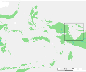
Cenderawasih Bay
Encyclopedia
Papua (Indonesian province)
Papua comprises most of the western half of the island of New Guinea and nearby islands. Its capital is Jayapura. It's the largest and easternmost province of Indonesia. The province originally covered the entire western half of New Guinea...
and West Papua, New Guinea
New Guinea
New Guinea is the world's second largest island, after Greenland, covering a land area of 786,000 km2. Located in the southwest Pacific Ocean, it lies geographically to the east of the Malay Archipelago, with which it is sometimes included as part of a greater Indo-Australian Archipelago...
, Indonesia
Indonesia
Indonesia , officially the Republic of Indonesia , is a country in Southeast Asia and Oceania. Indonesia is an archipelago comprising approximately 13,000 islands. It has 33 provinces with over 238 million people, and is the world's fourth most populous country. Indonesia is a republic, with an...
, at 2.5°S 135.3°E. The Dutch name comes after a Dutch ship and family called Geelvinck
Geelvinck
Geelvinck was a Dutch surname. The family died out in the early 19th century.Some notable members of the family include:* Jan Cornelis Geelvinck, the son of a merchant in beans and peas, and involved in the West India Company...
. The western part of the bay was declared a marine national park
Teluk Cenderawasih National Park
Teluk Cenderawasih National Park is the largest marine national park of Indonesia, located in Cenderawasih Bay, south-east of Bird's Head Peninsula. It includes the islands of Mioswaar, Nusrowi, Roon, Rumberpon and Yoop...
in 2002.
Islands in the Bay
West Papua Province:- Auri Islands archipelago (kepulauan Auri)
- Meos Waar
- Rumberpon
- Roon Island
- Meos Angra
Papua Province:
- Biak Islands (aka Schouten archipelago):
- BiakBiakBiak features a tropical rainforest climate with nearly identical temperatures throughout the course of the year. The average annual temperature in the city is 27 degrees celsius, which is also generally the average temperature of each day in Biak...
- Padaido Islands (kepulauan Padaido)
- Numfor
- YapenYapenYapen is an island of western New Guinea, Indonesia. The Yapen Strait separates Yapen and the Biak Islands to the north. It is in Cenderawasih Bay. To the west is Mios Num Strait between it and Mios Num Island, and the east Kurudu Island. The southeast are the Amboi Islands and the southwest...
- Mios NumMios NumMios Num is an island of western New Guinea, Indonesia, just west of Yapen. The Mios Num Strait separates it from Yapen. It is in Cenderawasih Bay. Numfoor and Biak are to the north, with Aruri Strait in between....
- Kaipuri
- SupioriSupioriSupiori is an island just west of Biak in the Schouten Islands in Papua province, Indonesia. It has a rugged surface with highest point at 1034 metres. Its area is 659 square kilometres....
- Amboi IslandsAmboi IslandsThe Ambai Islands are an island group of small scattered islands off the southern coast of Yapen Island, Cenderawasih Bay, eastern Indonesia in the Cenderawasih Bay off the northern coast of New Guinea. To the west are the Kuran Islands...
- Kuran IslandsKuran IslandsThe Kuran Islands are an island group of small scattered islands off the southwestern coast of Yapen Island, Cenderawasih Bay, eastern Indonesia off the northern coast of New Guinea. To the east are the Amboi Islands....
- Biak
- Moor Islands archipelago (kepulauan Moor) in Cenderawasih Bay
The Wamma River, Tabai River, Warenai River
Warenai River
Warenai River is a river in northern New Guinea, Indonesia.Tributaries include the Wapoga River....
, and Wapoga River
Wapoga River
Wapoga River is a river in northern New Guinea, Indonesia.It is a tributary of the Warenai River....
s empty into it.
The Mapia Islands lies to the north, and south of Palau
Palau
Palau , officially the Republic of Palau , is an island nation in the Pacific Ocean, east of the Philippines and south of Tokyo. In 1978, after three decades as being part of the United Nations trusteeship, Palau chose independence instead of becoming part of the Federated States of Micronesia, a...
. Bird's Head Peninsula
Bird's Head Peninsula
The Bird's Head Peninsula or Doberai Peninsula is a large peninsula that makes up the northwest portion of the Province of West Papua, Indonesia.-Location and geography:...
makes the northwest part of the Bay.