

Caswell Hill, Saskatoon
Encyclopedia
| City of Saskatoon Neighbourhoods | |
|---|---|
| Caswell Hill | |
| Core Neighbourhoods Suburban Development Area | |
 |
|
 |
|
| Population: | 3,505 |
| Average Family Income: | $40,217 |
| Average Household Size: | 2.2 |
| Homeownership: | 57.8% |
| Average Home Selling Price: | $81,972 |
| Municipal Ward: | 1 |
| Statistics c2005 - | |
Caswell Hill is a district in the Canadian city of Saskatoon
Saskatoon
Saskatoon is a city in central Saskatchewan, Canada, on the South Saskatchewan River. Residents of the city of Saskatoon are called Saskatonians. The city is surrounded by the Rural Municipality of Corman Park No. 344....
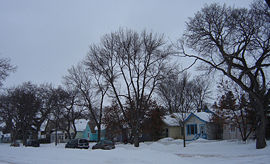
. It derives its name from an early homesteader Robert Caswell one of the Temperance Colonists of 1883. It is an area of beautiful character homes first built c 1905, tiny war-time houses, and newer houses. Caswell is a thriving and diverse community nestled between two economic areas, the downtown core, and the stores lining 33rd Street West.
Layout
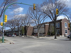
Streets are laid out east and west, avenues are laid out running north and south. Streets increment in number as travel heads northward. Avenues increment alphabetically as travel proceeds west. The whole of the Caswell Hill community is also laid out in a grid pattern.Historic sites
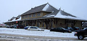
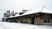
Saskatoon Railway Station (Canadian Pacific)
The Saskatoon Railway Station is a National Historic Site of Canada in Saskatoon, Saskatchewan, Canada which was officially declared on December 19, 1994 as having national historical significance. There is protected area status on this Château style station site. Saskatoon earned the nickname...
is one of many Saskatoon buildings listed in the Canadian Register of Historic Places
Canadian Register of Historic Places
The Canadian Register of Historic Places is an online, searchable database that includes listings of historic places important to communities, cities, provinces, territories, and the nation...
. It is a Château style station which was built in 1907. Its current address is 305 Idylwyld Drive
Idylwyld Drive
Idylwyld Drive is an arterial road in Saskatoon, Saskatchewan. It is one of the main roads in and out of the downtown area of the city.On the south side of the Senator Sid Buckwold Bridge, it is a freeway and is known as the Idylwyld Freeway. It eventually turns into Circle Drive, just east of...
North, Idylwyld Drive used to be called Avenue A.
Education

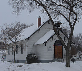
- Ashworth Holmes School opened for classes in 1909. It was constructed on Ashworth Holmes Hill (Present day site of Mayfair Pool)
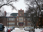
- Caswell School a public elementary school was constructed 1910 and again named for Robert W. Caswell who had farmed at this location.
- Bedford Road CollegiateBedford Road CollegiateBedford Road Collegiate is a high school on the west side of the city of Saskatoon, Saskatchewan. It is Saskatoon's second oldest high school educating students since February 12, 1923. It is also known as BRCI , or Bedford...
Public Secondary school
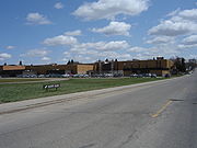
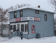
Shopping
Area parks
- Ashworth – Holmes Park (12.68 acres) derived its name from J. H. HOlmes and John Ashworth. This realtors of the early 1900s purchased most of the land now named the Caswell Hill Subdivision. (Their purchase was bordered by Idylwyld to Avenue H and 22nd22nd Street (Saskatoon)22nd Street is an arterial road in Saskatoon, Saskatchewan. It starts out as 22nd Street East in the Central Business District. Going west it passes the Midtown Plaza and TCU Place. At the intersection with Idylwyld Drive, it becomes 22nd Street West...
to 29th Streets) They subdivided the land and sold it, but donated 10 acres (40,468.6 m²) to the City which became this park area.Wikimapia – Let's describe the whole world! URL accessed February 4, 2007
City transit
Caswell Hill is serviced by City TransitSaskatoon Transit
Saskatoon Transit is the public transport arm of the City of Saskatoon, Saskatchewan, Canada. It operates a fleet of diesel buses. A total of 23 bus routes serve every area of the city, carrying approximately 11 million passengers in 2008...
Bus Routes and since 1913, has housed the city's original streetcar building at Avenue C and 24th Street. The city transit headquarters afterwards adopted these buildings for bus warehouse garages and offices between Avenue C and D at 24th Street. A seven million CA$ consultant plan has been approved by the Saskatoon
Saskatoon
Saskatoon is a city in central Saskatchewan, Canada, on the South Saskatchewan River. Residents of the city of Saskatoon are called Saskatonians. The city is surrounded by the Rural Municipality of Corman Park No. 344....
planning and operations committee to relocate the transit bus barns. The Caswell neighborhood will be revitalised by renovating the 13 acres (52,609.2 m²) area with a community for artists and musicians enhanced with a music festival.
22nd Street (Highway 14
Saskatchewan Highway 14
Highway 14 is a highway in the Canadian province of Saskatchewan. It runs from the intersection of Idylwyld Drive and 22nd Street in downtown Saskatoon, westward to the Albertan border where it becomes Highway 13. It is approximately 261 km long.Prior to the 1970's, Highway 14 ran the width...
) is a major thoroughfare through Saskatoon. Highway 7
Saskatchewan Highway 7
Saskatchewan Highway 7 is a major paved undivided provincial highway in the Canadian province of Saskatchewan, running from the Alberta border to Saskatoon...
has its junction at (Highway 14
Saskatchewan Highway 14
Highway 14 is a highway in the Canadian province of Saskatchewan. It runs from the intersection of Idylwyld Drive and 22nd Street in downtown Saskatoon, westward to the Albertan border where it becomes Highway 13. It is approximately 261 km long.Prior to the 1970's, Highway 14 ran the width...
. Highway 14
Saskatchewan Highway 14
Highway 14 is a highway in the Canadian province of Saskatchewan. It runs from the intersection of Idylwyld Drive and 22nd Street in downtown Saskatoon, westward to the Albertan border where it becomes Highway 13. It is approximately 261 km long.Prior to the 1970's, Highway 14 ran the width...
connects with Asquith
Asquith, Saskatchewan
-External links:*...
, Biggar
Biggar, Saskatchewan
Biggar is a town in central Saskatchewan, Canada. It is located on Highway #14, west of Saskatoon, the province’s most populous city. Biggar has become well known for its unusual town slogan, an Olympic athlete, and a world-record deer...
Wilkie
Wilkie, Saskatchewan
Wilkie is a town in Saskatchewan, Canada located at Section 5, Township 40, Range 19, west of the 3rd Meridian .On February 2, 1907, the first post office was established with the name Glenlogan at Section 4, Township 40, Range 19, west of the 3rd Meridian. The post office changed names on October...
, Unity
Unity, Saskatchewan
-Area statistics:*Lat 52°26′ N*Long 109°10′00″ W*Dominion Land Survey Section 18, Township 40, Range 22, West of the 3rd Meridian*Time zone UTC−6-Location:-See also:*List of towns in Saskatchewan...
, and Macklin en route to Alberta
Alberta
Alberta is a province of Canada. It had an estimated population of 3.7 million in 2010 making it the most populous of Canada's three prairie provinces...
.
Idylwyld Drive has had many titles: Avenue A, (Highway 11
Saskatchewan Highway 11
Highway 11 is a major north-south highway in Saskatchewan, Canada that connects the province's three largest cities: Regina, Saskatoon and Prince Albert. It is a structural pavement major arterial highway which is approximately long. It is also known as the Louis Riel Trail after the 19th century...
and most currently Louis Riel Trail. It is a main thoroughfare through the city connecting Regina
Regina, Saskatchewan
Regina is the capital city of the Canadian province of Saskatchewan. The city is the second-largest in the province and a cultural and commercial centre for southern Saskatchewan. It is governed by Regina City Council. Regina is the cathedral city of the Roman Catholic and Romanian Orthodox...
, Saskatoon
Saskatoon
Saskatoon is a city in central Saskatchewan, Canada, on the South Saskatchewan River. Residents of the city of Saskatoon are called Saskatonians. The city is surrounded by the Rural Municipality of Corman Park No. 344....
and Prince Albert, Saskatchewan
Prince Albert, Saskatchewan
Prince Albert is the third-largest city in Saskatchewan, Canada. It is situated in the centre of the province on the banks of the North Saskatchewan River. The city is known as the "Gateway to the North" because it is the last major centre along the route to the resources of northern Saskatchewan...
. It also connects west Saskatoon with the bedroom communities of Warman
Warman, Saskatchewan
-History:The town of Warman was born when the Canadian National Railway running from Humboldt to North Battleford intersected with the Canadian Pacific Railway running from Regina to Prince Albert. This took place in the fall of 1904....
and Martensville
Martensville, Saskatchewan
Martensville is a city located in Saskatchewan, Canada, just north of Saskatoon, and south west of Clarkboro Ferry which crosses the South Saskatchewan River. Martensville is one of the fastest growing communities in Saskatchewan, with the population growing 25% between 1996 and 2001. It is...
Life
Kelsey Community Association provides leisure activities for various age groups and operates out of Caswell School City of Saskatoon · Departments · Community Services · Community URL accessed February 2, 2007Location
| North: Mayfair | ||
| West: Hudson Bay Park | Westmount | Caswell Hill | East: Central Industrial | Central Business District |
| South: Riversdale |