

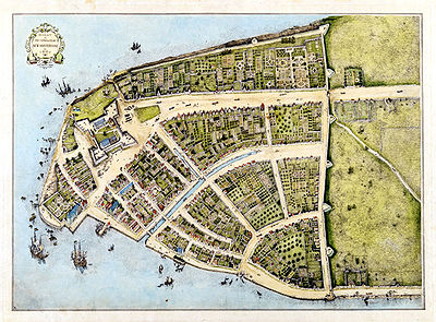
Castello Plan
Encyclopedia
City map
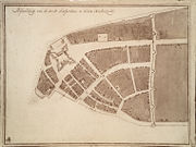
A city map is a large-scale thematic map of a city created to enable the fastest possible orientation in an urban space. The graphic representation of objects on a city map is therefore usually greatly simplified, and reduced to generally understood symbology.Depending upon its target group or...
of Lower Manhattan
Lower Manhattan
Lower Manhattan is the southernmost part of the island of Manhattan, the main island and center of business and government of the City of New York...
(New York City
New York City
New York is the most populous city in the United States and the center of the New York Metropolitan Area, one of the most populous metropolitan areas in the world. New York exerts a significant impact upon global commerce, finance, media, art, fashion, research, technology, education, and...
) from 1660, created by Jacques Cortelyou
Jacques Cortelyou
Jacques Cortelyou was an influential early citizen of New Amsterdam who was Surveyor General of the early Dutch colony...
, surveyor of New Amsterdam
New Amsterdam
New Amsterdam was a 17th-century Dutch colonial settlement that served as the capital of New Netherland. It later became New York City....
at that time.
Around 1667, cartographer Joan Blaeu
Joan Blaeu
Joan Blaeu was a Dutch cartographer.He was born in Alkmaar, the son of cartographer Willem Blaeu.In 1620 he became a doctor of law but he joined the work of his father. In 1635 they published the Atlas Novus in two volumes...
bound the plan, together with other hand-crafted New Amsterdam depictions, to an atlas
Atlas
An atlas is a collection of maps; it is typically a map of Earth or a region of Earth, but there are atlases of the other planets in the Solar System. Atlases have traditionally been bound into book form, but today many atlases are in multimedia formats...
, which he sold to Cosimo III de’ Medici
Medici
The House of Medici or Famiglia de' Medici was a political dynasty, banking family and later royal house that first began to gather prominence under Cosimo de' Medici in the Republic of Florence during the late 14th century. The family originated in the Mugello region of the Tuscan countryside,...
. This transaction most likely happened in Amsterdam, Netherlands, as it has yet to be proven that Blaeu had ever set foot in New Netherland
New Netherland
New Netherland, or Nieuw-Nederland in Dutch, was the 17th-century colonial province of the Republic of the Seven United Netherlands on the East Coast of North America. The claimed territories were the lands from the Delmarva Peninsula to extreme southwestern Cape Cod...
.
The plan arrived in Italy
Italy
Italy , officially the Italian Republic languages]] under the European Charter for Regional or Minority Languages. In each of these, Italy's official name is as follows:;;;;;;;;), is a unitary parliamentary republic in South-Central Europe. To the north it borders France, Switzerland, Austria and...
, where it was found in Villa di Castello near Florence
Florence
Florence is the capital city of the Italian region of Tuscany and of the province of Florence. It is the most populous city in Tuscany, with approximately 370,000 inhabitants, expanding to over 1.5 million in the metropolitan area....
in 1900 and printed in 1916, thus receiving its name.
It is covered extensively in volume 2 of I. N. Phelps Stokes Iconography of Manhattan Island
The Iconography of Manhattan Island
The Iconography of Manhattan Island is a six volume study of the history of New York City by Isaac Newton Phelps-Stokes, published between 1915 and 1928 by R. H. Dodd in New York. The work comprehensively records and documents key events of the city's chronology from the sixth to the early...
External links
- Iconography of Manhattan Island from Columbia University Libraries
- Overlay of the Castello Plan on current Manhattan
- List of property owners
- Map scanned from the book "The Legend of New Amsterdam"
- Interactive version of the Castello Plan
- Google Earth File of the Castello Plan
- Zoomable version of the Castello Plan