

Cass County, Minnesota
Encyclopedia
Cass County is a county located in the U.S. state
of Minnesota
. As of 2010, the population was 28,567. Its county seat
is Walker
. A portion of the Leech Lake Indian Reservation
is in the county.
See also: List of counties bordering eight counties
. However, it was not formally organized until 1897. Cass County was formed from portions of Dakota
, Mahkatah, Pembina
and Wahnata Counties. The county was named in honor of Lewis Cass
.
of 2000, there were 27,150 people, 10,893 households, and 7,734 families residing in the county. The population density
was 14 people per square mile (5/km²). There were 21,286 housing units at an average density of 11 per square mile (4/km²). The racial makeup of the county was 86.52% White
, 0.11% Black
or African American
, 11.45% Native American
, 0.28% Asian
, 0.02% Pacific Islander
, 0.14% from other races
, and 1.47% from two or more races. 0.81% of the population were Hispanic
or Latino
of any race. 28.2% were of German, 15.0% Norwegian, 7.3% Swedish, 6.1% Irish
and 6.1% American
ancestry according to Census 2000.
There were 10,893 households out of which 27.70% had children under the age of 18 living with them, 58.40% were married couples
living together, 8.00% had a female householder with no husband present, and 29.00% were non-families. 25.00% of all households were made up of individuals and 11.90% had someone living alone who was 65 years of age or older. The average household size was 2.45 and the average family size was 2.90.
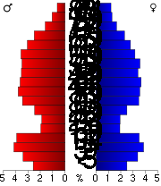 In the county the population was spread out with 25.00% under the age of 18, 6.10% from 18 to 24, 23.00% from 25 to 44, 27.90% from 45 to 64, and 18.00% who were 65 years of age or older. The median age was 42 years. For every 100 females there were 101.90 males. For every 100 females age 18 and over, there were 100.60 males.
The median income for a household in the county was $34,332, and the median income for a family was $40,156. Males had a median income of $30,097 versus $21,232 for females. The per capita income
for the county was $17,189. About 9.50% of families and 13.60% of the population were below the poverty line, including 18.20% of those under age 18 and 13.30% of those age 65 or over.
† Only a small part of Motley is in Cass County.
U.S. state
A U.S. state is any one of the 50 federated states of the United States of America that share sovereignty with the federal government. Because of this shared sovereignty, an American is a citizen both of the federal entity and of his or her state of domicile. Four states use the official title of...
of Minnesota
Minnesota
Minnesota is a U.S. state located in the Midwestern United States. The twelfth largest state of the U.S., it is the twenty-first most populous, with 5.3 million residents. Minnesota was carved out of the eastern half of the Minnesota Territory and admitted to the Union as the thirty-second state...
. As of 2010, the population was 28,567. Its county seat
County seat
A county seat is an administrative center, or seat of government, for a county or civil parish. The term is primarily used in the United States....
is Walker
Walker, Minnesota
As of the census of 2000, there were 1,069 people, 449 households, and 258 families residing in the city. The population density was 734.3 people per square mile . There were 517 housing units at an average density of 355.1 per square mile...
. A portion of the Leech Lake Indian Reservation
Leech Lake Indian Reservation
The Leech Lake Indian Reservation or Gaa-zagaskwaajimekaag in the Ojibwe language, is an Native American reservation located in the north-central Minnesota counties of Cass, Itasca, Beltrami, and Hubbard. It is the land-base for the Leech Lake Band of Ojibwe...
is in the county.
Geography
According to the 2000 census, the county has a total area of 2414.21 square miles (6,252.8 km²), of which 2017.6 square miles (5,225.6 km²) (or 83.57%) is land and 396.61 square miles (1,027.2 km²) (or 16.43%) is water.Major highways
|
 Minnesota State Highway 87 Minnesota State Highway 87Minnesota State Highway 87 Minnesota State Highway 87 is a highway in north-central and northwest Minnesota, which runs from its interchange with U.S. Highway 10 at Frazee and continues east to its eastern terminus at its intersection with State Highway 84 in Ponto Lake Township, east of Backus and southwest of...  Minnesota State Highway 200 Minnesota State Highway 200Minnesota State Highway 200 Minnesota State Highway 200 is a highway in northwest and northeast Minnesota,which runs from North Dakota Highway 200 at the North Dakota state line near Halstad, and continues east to its eastern terminus at its intersection with U.S...  Minnesota State Highway 210 Minnesota State Highway 210Minnesota State Highway 210 Minnesota State Highway 210 is a highway in west-central, central, and northeast Minnesota, which runs from North Dakota Highway 210 at the North Dakota state line , and continues east to its eastern terminus at its intersection with State Highway 23 in Duluth near the Saint Louis River.The route...  Minnesota State Highway 371 Minnesota State Highway 371Minnesota State Highway 371 Minnesota 371 was originally designated as US 371 from 1931 to 1973. During 1973, US 371 was re-designated Minnesota 371. The former US 371 designation was concurrent with US 2 from 1931 to 1973 between Cass Lake and Bemidji with a terminus at US 71.Subsequently,... |


Adjacent counties
- Itasca CountyItasca County, MinnesotaItasca County is a county located in the U.S. state of Minnesota. It is named after Lake Itasca, which is in turn a shortened version the Latin words veritas caput, meaning 'truth' and 'head', a reference to the source of the Mississippi River. As of 2010, the population was 45,058. Its county seat...
(northeast) - Aitkin CountyAitkin County, MinnesotaAitkin County is a county located in the U.S. state of Minnesota. As of 2010, the population is 16,202. Its county seat is Aitkin. A portion of the Mille Lacs Indian Reservation is in the county.-History:...
(southeast) - Crow Wing CountyCrow Wing County, MinnesotaCrow Wing County is a county located in the U.S. state of Minnesota. As of 2010, the population was 62,500. Its county seat is Brainerd.-Geography:...
(southeast, south) - Morrison CountyMorrison County, Minnesota-Demographics:As of the census of 2000, there were 31,712 people, 11,816 households, and 8,460 families residing in the county. The population density was 28 people per square mile . There were 13,870 housing units at an average density of 12 per square mile...
(south) - Todd CountyTodd County, Minnesota-External links:*...
(southwest) - Wadena CountyWadena County, MinnesotaAs of the census of 2000, there were 13,713 people, 5,426 households, and 3,608 families residing in the county. The population density was 26 people per square mile . There were 6,334 housing units at an average density of 12 per square mile...
(west,southwest) - Hubbard CountyHubbard County, MinnesotaAs of the census of 2000, there were 18,376 people, 7,435 households, and 5,345 families residing in the county. The population density was 20 people per square mile . There were 12,229 housing units at an average density of 13 per square mile...
(northwest) - Beltrami CountyBeltrami County, MinnesotaBeltrami County is a county located in the northern part of the U.S. state of Minnesota. As of 2010, the population was 44,442. Its county seat is Bemidji. Portions of the Leech Lake and Red Lake Indian reservations are in the county. The northernmost portion of the Mississippi River flows...
(northwest)
See also: List of counties bordering eight counties
History
Cass County was created on September 1, 1851 by the legislature of the Minnesota TerritoryMinnesota Territory
The Territory of Minnesota was an organized incorporated territory of the United States that existed from March 3, 1849, until May 11, 1858, when the eastern portion of the territory was admitted to the Union as the State of Minnesota.-History:...
. However, it was not formally organized until 1897. Cass County was formed from portions of Dakota
Dakota County, Minnesota
Dakota County is the third most populous county in the U.S. state of Minnesota. The county is bordered by the Minnesota and Mississippi Rivers on the north, and the state of Wisconsin on the east. Dakota County comprises the southeast portion of seven-county Minneapolis-St. Paul, the thirteenth...
, Mahkatah, Pembina
Kittson County, Minnesota
As of the census of 2000, there were 5,285 people, 2,167 households, and 1,447 families residing in the county. The population density was 5 people per square mile . There were 2,719 housing units at an average density of 2 per square mile...
and Wahnata Counties. The county was named in honor of Lewis Cass
Lewis Cass
Lewis Cass was an American military officer and politician. During his long political career, Cass served as a governor of the Michigan Territory, an American ambassador, a U.S. Senator representing Michigan, and co-founder as well as first Masonic Grand Master of the Grand Lodge of Michigan...
.
Demographics
As of the censusCensus
A census is the procedure of systematically acquiring and recording information about the members of a given population. It is a regularly occurring and official count of a particular population. The term is used mostly in connection with national population and housing censuses; other common...
of 2000, there were 27,150 people, 10,893 households, and 7,734 families residing in the county. The population density
Population density
Population density is a measurement of population per unit area or unit volume. It is frequently applied to living organisms, and particularly to humans...
was 14 people per square mile (5/km²). There were 21,286 housing units at an average density of 11 per square mile (4/km²). The racial makeup of the county was 86.52% White
Race (United States Census)
Race and ethnicity in the United States Census, as defined by the Federal Office of Management and Budget and the United States Census Bureau, are self-identification data items in which residents choose the race or races with which they most closely identify, and indicate whether or not they are...
, 0.11% Black
Race (United States Census)
Race and ethnicity in the United States Census, as defined by the Federal Office of Management and Budget and the United States Census Bureau, are self-identification data items in which residents choose the race or races with which they most closely identify, and indicate whether or not they are...
or African American
Race (United States Census)
Race and ethnicity in the United States Census, as defined by the Federal Office of Management and Budget and the United States Census Bureau, are self-identification data items in which residents choose the race or races with which they most closely identify, and indicate whether or not they are...
, 11.45% Native American
Race (United States Census)
Race and ethnicity in the United States Census, as defined by the Federal Office of Management and Budget and the United States Census Bureau, are self-identification data items in which residents choose the race or races with which they most closely identify, and indicate whether or not they are...
, 0.28% Asian
Race (United States Census)
Race and ethnicity in the United States Census, as defined by the Federal Office of Management and Budget and the United States Census Bureau, are self-identification data items in which residents choose the race or races with which they most closely identify, and indicate whether or not they are...
, 0.02% Pacific Islander
Race (United States Census)
Race and ethnicity in the United States Census, as defined by the Federal Office of Management and Budget and the United States Census Bureau, are self-identification data items in which residents choose the race or races with which they most closely identify, and indicate whether or not they are...
, 0.14% from other races
Race (United States Census)
Race and ethnicity in the United States Census, as defined by the Federal Office of Management and Budget and the United States Census Bureau, are self-identification data items in which residents choose the race or races with which they most closely identify, and indicate whether or not they are...
, and 1.47% from two or more races. 0.81% of the population were Hispanic
Race (United States Census)
Race and ethnicity in the United States Census, as defined by the Federal Office of Management and Budget and the United States Census Bureau, are self-identification data items in which residents choose the race or races with which they most closely identify, and indicate whether or not they are...
or Latino
Race (United States Census)
Race and ethnicity in the United States Census, as defined by the Federal Office of Management and Budget and the United States Census Bureau, are self-identification data items in which residents choose the race or races with which they most closely identify, and indicate whether or not they are...
of any race. 28.2% were of German, 15.0% Norwegian, 7.3% Swedish, 6.1% Irish
Irish people
The Irish people are an ethnic group who originate in Ireland, an island in northwestern Europe. Ireland has been populated for around 9,000 years , with the Irish people's earliest ancestors recorded having legends of being descended from groups such as the Nemedians, Fomorians, Fir Bolg, Tuatha...
and 6.1% American
United States
The United States of America is a federal constitutional republic comprising fifty states and a federal district...
ancestry according to Census 2000.
There were 10,893 households out of which 27.70% had children under the age of 18 living with them, 58.40% were married couples
Marriage
Marriage is a social union or legal contract between people that creates kinship. It is an institution in which interpersonal relationships, usually intimate and sexual, are acknowledged in a variety of ways, depending on the culture or subculture in which it is found...
living together, 8.00% had a female householder with no husband present, and 29.00% were non-families. 25.00% of all households were made up of individuals and 11.90% had someone living alone who was 65 years of age or older. The average household size was 2.45 and the average family size was 2.90.
The median income for a household in the county was $34,332, and the median income for a family was $40,156. Males had a median income of $30,097 versus $21,232 for females. The per capita income
Per capita income
Per capita income or income per person is a measure of mean income within an economic aggregate, such as a country or city. It is calculated by taking a measure of all sources of income in the aggregate and dividing it by the total population...
for the county was $17,189. About 9.50% of families and 13.60% of the population were below the poverty line, including 18.20% of those under age 18 and 13.30% of those age 65 or over.
Cities and towns
| Cities | Townships | Unorganized | Unincorporated | |
|---|---|---|---|---|
|
Becker Township, Cass County, Minnesota Becker Township is a township in Cass County, Minnesota, United States. The population was 485 as of the 2000 census.-Geography:According to the United States Census Bureau, the township has a total area of , of which is land and is water.... Byron Township, Cass County, Minnesota Byron Township is a township in Cass County, Minnesota, United States. The population was 118 as of the 2000 census.-Geography:According to the United States Census Bureau, the township has a total area of , of which is land and is water.... Deerfield Township, Cass County, Minnesota Deerfield Township is a township in Cass County, Minnesota, United States. The population was 154 as of the 2000 census.-Geography:According to the United States Census Bureau, the township has a total area of , of which is land and is water.... Fairview Township, Cass County, Minnesota Fairview Township is a township in Cass County, Minnesota, United States. The population was 567 as of the 2000 census.-Geography:According to the United States Census Bureau, the township has a total area of , of which is land and is water.... May Township, Cass County, Minnesota May Township is a township in Cass County, Minnesota, United States. The population was 730 at the 2000 census.-Geography:According to the United States Census Bureau, the township has a total area of 60.6 square miles , of which 60.0 square miles is land and 0.6 square miles is... |
Moose Lake Township, Cass County, Minnesota Moose Lake Township is a township in Cass County, Minnesota, United States. The population was 142 as of the 2000 census.-Geography:According to the United States Census Bureau, the township has a total area of 38.7 square miles , of which 37.5 square miles is land and 1.2 square... Pine Lake Township, Cass County, Minnesota Pine Lake Township is a township in Cass County, Minnesota, United States. The population was 170 as of the 2000 census.-Geography:According to the United States Census Bureau, the township has a total area of 34.4 square miles , of which 28.4 square miles is land and 6.0 square... Salem Township, Cass County, Minnesota Salem Township is a township in Cass County, Minnesota, United States. The population was 78 as of the 2000 census.-Geography:According to the United States Census Bureau, the township has a total area of 36.4 square miles , of which 35.1 square miles is land and 1.3 square miles ... Turtle Lake Township, Cass County, Minnesota Turtle Lake Township is a township in Cass County, Minnesota, United States. The population was 699 as of the 2000 census.-Geography:According to the United States Census Bureau, the township has a total area of 72.0 square miles , of which 48.7 square miles is land and 23.3 square... Walden Township, Cass County, Minnesota Walden Township is a township in Cass County, Minnesota, United States. The population was 405 as of the 2000 census.-Geography:According to the United States Census Bureau, the township has a total area of 36.2 square miles , of which 36.2 square miles is land and 0.04 square miles... Wilson Township, Cass County, Minnesota Wilson Township is a township in Cass County, Minnesota, United States. The population was 551 as of the 2000 census.-Geography:According to the United States Census Bureau, the township has a total area of 17.9 square miles , of which 17.7 square miles is land and 0.1 square miles ... Woodrow Township, Cass County, Minnesota Woodrow Township is a township in Cass County, Minnesota, United States. The population was 667 as of the 2000 census.-Geography:According to the United States Census Bureau, the township has a total area of 36.8 square miles , of which 25.1 square miles is land and 11.7 square... |
Wahnena, Minnesota Wahnena is an unorganized territory in Cass County, Minnesota, United States. The population was 197 at the 2000 census. It is part of the Brainerd Micropolitan Statistical Area.-Geography:... North Cass, Minnesota North Cass is an unorganized territory in Cass County, Minnesota, United States. The population was 348 at the 2000 census. It is part of the Brainerd Micropolitan Statistical Area.-Geography:... North Central Cass, Minnesota North Central Cass is an unorganized territory in Cass County, Minnesota, United States. The population was 24 at the 2000 census. It is part of the Brainerd Micropolitan Statistical Area.-Geography:... East Cass, Minnesota East Cass is an unorganized territory in Cass County, Minnesota, United States. The population was 43 at the 2000 census. It is part of the Brainerd Micropolitan Statistical Area.-Geography:... |
Ah-gwah-ching, Minnesota Ah-gwah-ching is an unincorporated community in Cass County, Minnesota, United States. Ah-gwah-ching is located along Minnesota State Highway 200 and Minnesota State Highway 371 south-southeast of Walker. Ah-gwah-ching has a post office with ZIP code 56430.... Outing, Minnesota Outing is an unincorporated community in Cass County, Minnesota, United States. It is part of the Brainerd Micropolitan Statistical Area.The community is located between Crosby and Remer on Minnesota State Highway 6.The Clint Converse campground is nearby.... Pontoria, Minnesota Pontoria is an unincorporated community in Ponto Lake Township, Cass County, Minnesota, United States. It is part of the Brainerd Micropolitan Statistical Area.... |
† Only a small part of Motley is in Cass County.
Climate and weather
In recent years, average temperatures in the county seat of Walker have ranged from a low of 0 °F (-17.8 °C) in January to a high of 79 °F (26.1 °C) in July, although a record low of -44 °F was recorded in February 1996 and a record high of 103 °F (39.4 °C) was recorded in August 1976. Average monthly precipitation ranged from 0.62 inches (1.6 cm) in February to 4.11 inches (10.4 cm) in July.External links
- Cass County government's website
- Minnesota Department of TransportationMinnesota Department of TransportationThe Minnesota Department of Transportation oversees transportation by land, water, and air in the U.S. state of Minnesota. The cabinet-level agency is responsible for maintaining the state's trunk highway system The Minnesota Department of Transportation (Mn/DOT, pronounced "min-dot") oversees...
map of Cass County (southern portion, west central portion, east central portion, northern portion)