
Carson River
Encyclopedia
The Carson River is a northwestern Nevada river that empties into the Carson Sink
, an endorheic basin
. The main stem of the river is 131 miles (210.8 km) long.
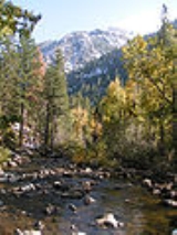
It rises in two forks in the Sierra Nevada of northern California. The 68 miles (109.4 km) East Fork rises in southern Alpine County
, southeast of Markleeville
in the Carson-Iceberg Wilderness
. The 40 miles (64.4 km) West Fork rises in the Sierras near Carson Pass
and flows northeast into Nevada, joining the East Fork. The Carson River then flows north, passing through Carson City
, then generally northeast past across Lyon County
, past Dayton
. In eastern Churchill County
it is impounded by the Lahontan Dam
to form the Lake Lahontan
reservoir for irrigation
and hydroelectricity
. Downstream from the dam the river flows east past Fallon
, then northeast into the Carson Sink.
Archaeological finds place the eastern border for the prehistoric Martis people
in the Reno
/Carson River area.
In the 1850s and 1860s, the river was used as the route of the Carson Trail, a branch of the California Trail
that allowed access to the California gold fields
, as well as by the Pony Express
. The 1868 Virginia and Truckee Railroad
transported ore to the quartz reduction mines along the river. In the early 20th century, the Newlands project was formed to bring irrigation water into the region for agriculture. The Lahontan Dam was constructed as part of the ongoing project. The Truckee-Carson Irrigation District
was formed in 1918 as part of the project to divert water from the Truckee River
to the Carson Valley for agricultural use.
, have a word for beaver, c'imhélhel. Powers reported that the northern Paiute wrapped their hair in strips of beaver fur, made medicine from parts of beaver and that their creation legend included beaver, which they called "Su-i'-tu-ti-kut'-teh". Given the hydrological connection of the Humboldt River
and Sink
to the Carson Sink
during flood years (as recently as 1998), it is not surprising that beavers were historically extant on eastern Sierra watercourses. Peter Skene Ogden
, on a Hudson's Bay Company
expedition to the terminus of the Humboldt River, wrote in his diary on May 15, 1829, "In no part have I found beaver so abundant. The total number of American trappers in this region at this time exceeds 80. I have only 28 trappers... The trappers now average 125 beaver a man and are greatly pleased with their success."
, river rafting
, mountain biking
, off-roading
, hunting
, and horse-back riding. Development along the river in Douglas, Carson City, and Lyon counties has limited public access in some areas.
Carson Sink
Carson Sink is a playa in the northeastern portion of the Carson Desert that was formerly the terminus of the Carson River. The sink is currently fed by drainage canals of the Truckee-Carson Irrigation District...
, an endorheic basin
Sink (geography)
A geographic sink is a depression within an endorheic basin where water collects with no visible outlet. Instead of discharging, the collected water is lost due to evaporation and/or penetration...
. The main stem of the river is 131 miles (210.8 km) long.
It rises in two forks in the Sierra Nevada of northern California. The 68 miles (109.4 km) East Fork rises in southern Alpine County
Alpine County, California
Alpine County is the smallest county, by population, in the U.S. state of California. As of 2010, it had a population of 1,175, all rural. There are no incorporated cities in the county. The county seat is Markleeville...
, southeast of Markleeville
Markleeville, California
Markleeville is a census-designated place and the county seat of Alpine County, California. The population was 210 at the 2010 census, up from 197 at the 2000 census.The CDP of Markleeville also includes Woodfords....
in the Carson-Iceberg Wilderness
Carson-Iceberg Wilderness
The Carson-Iceberg Wilderness is a federal wilderness area located northeast of Stockton, California. It encompasses and was designated by the California Wilderness Act of 1984. It protects an area of High Sierra landscape with elevations from to along the Sierra Mountains from Ebbetts Pass...
. The 40 miles (64.4 km) West Fork rises in the Sierras near Carson Pass
Carson Pass
Carson Pass is the Sierra Crest mountain pass over which State Route 88 crosses. The historic pass was a point on the Carson Trail during the California Gold Rush and was used for American Civil War shipping to California until the completion of the First Transcontinental Railroad...
and flows northeast into Nevada, joining the East Fork. The Carson River then flows north, passing through Carson City
Carson City, Nevada
The Consolidated Municipality of Carson City is the capital of the state of Nevada. The words Consolidated Municipality refer to a series of changes in 1969 which abolished Ormsby County and merged all the settlements contained within its borders into Carson City. Since that time Carson City has...
, then generally northeast past across Lyon County
Lyon County, Nevada
Lyon County is a county located in the U.S. state of Nevada. As of the 2010 census, the population was 51,980. Its county seat is Yerington.-History:...
, past Dayton
Dayton, Nevada
Dayton is a census-designated place in Lyon County, Nevada, United States. The population was 5,907 at the 2000 census.-History:Dayton is at the western end of the Twenty-Six Mile Desert at a bend in the Carson River. Immigrants stopping there for water would consider whether to follow the river...
. In eastern Churchill County
Churchill County, Nevada
Churchill County is a county located in the western U.S. state of Nevada. As of the 2000 census, the population was 23,982. As of July 1, 2007, the population of Churchill County was estimated at 27,190. The county, named after Mexican-American War hero brevet Brigadier General Sylvester Churchill,...
it is impounded by the Lahontan Dam
Lahontan Dam
The Lahontan Dam is a dam situated on the Carson River in the Carson Desert between Carson City, Nevada and Fallon, Nevada in the United States. Its impoundment is known as the Lahontan Reservoir or Lake Lahontan. It is currently operated by the Truckee-Carson Irrigation District.The Lahontan...
to form the Lake Lahontan
Lake Lahontan (reservoir)
Modern Lake Lahontan is a reservoir on the Carson River in northwest Nevada in the United States. It is formed by the Lahontan Dam and is located between Fallon, Nevada and Carson City, Nevada. The flows from the Carson River is augmented by diversions from the Truckee River...
reservoir for irrigation
Irrigation
Irrigation may be defined as the science of artificial application of water to the land or soil. It is used to assist in the growing of agricultural crops, maintenance of landscapes, and revegetation of disturbed soils in dry areas and during periods of inadequate rainfall...
and hydroelectricity
Hydroelectricity
Hydroelectricity is the term referring to electricity generated by hydropower; the production of electrical power through the use of the gravitational force of falling or flowing water. It is the most widely used form of renewable energy...
. Downstream from the dam the river flows east past Fallon
Fallon, Nevada
-Demographics:As of the census of 2000, there were 7,536 people, 3,004 households, and 1,877 families residing in the city. The population density was 2,474.1 people per square mile . There were 3,336 housing units at an average density of 1,095.2 per square mile...
, then northeast into the Carson Sink.
Archaeological finds place the eastern border for the prehistoric Martis people
Martis people
The Martis were a group of Native Americans who lived in Northern California on both the eastern and western sides of the Sierra Nevada. The Martis complex lasted from 2000 BCE to 500 CE, during the Middle Archaic era. Evidence of Martis habitation has been found from Carson River and Reno, Nevada...
in the Reno
Reno
Reno is the fourth most populous city in Nevada, US.Reno may also refer to:-Places:Italy*The Reno River, in Northern ItalyCanada*Reno No...
/Carson River area.
In the 1850s and 1860s, the river was used as the route of the Carson Trail, a branch of the California Trail
California Trail
The California Trail was an emigrant trail of about across the western half of the North American continent from Missouri River towns to what is now the state of California...
that allowed access to the California gold fields
California Gold Rush
The California Gold Rush began on January 24, 1848, when gold was found by James W. Marshall at Sutter's Mill in Coloma, California. The first to hear confirmed information of the gold rush were the people in Oregon, the Sandwich Islands , and Latin America, who were the first to start flocking to...
, as well as by the Pony Express
Pony Express
The Pony Express was a fast mail service crossing the Great Plains, the Rocky Mountains, and the High Sierra from St. Joseph, Missouri, to Sacramento, California, from April 3, 1860 to October 1861...
. The 1868 Virginia and Truckee Railroad
Virginia and Truckee Railroad
The Virginia and Truckee Railroad was built to serve the Comstock Lode mining communities of northwestern Nevada. At its height, the railroad's route ran from Reno south to Carson City, Nevada. In Carson City, the...
transported ore to the quartz reduction mines along the river. In the early 20th century, the Newlands project was formed to bring irrigation water into the region for agriculture. The Lahontan Dam was constructed as part of the ongoing project. The Truckee-Carson Irrigation District
Truckee-Carson Irrigation District
The Truckee-Carson Irrigation District is a political subdivision of the State of Nevada, which operates dams at Lake Tahoe, on the Truckee River and Lake Lahontan as well as of canals and of drains in support of agriculture in Lyon County and Churchill County.Diversion of water by the TCID from...
was formed in 1918 as part of the project to divert water from the Truckee River
Truckee River
The Truckee River is a stream in the U.S. states of California and Nevada. The river is about long. Its endorheic drainage basin is about , of which about are in Nevada. The Truckee is the sole outlet of Lake Tahoe and drains part of the high Sierra Nevada, emptying into Pyramid Lake in the Great...
to the Carson Valley for agricultural use.
Ecology
North American beaver (Castor canadensis) were re-introduced to the Carson River watershed around 1940 and populations have thrived since. There are eyewitness accounts of beaver in the upper Carson River through 1892. The Washo people who lived in the eastern Sierra with hunting grounds extending as far west as Calaveras CountyCalaveras County, California
Calaveras County is a county located in the Gold Country of the U.S. state of California. Calaveras is the Spanish word for skulls; the county was reportedly named for the remains of Native Americans discovered by the Spanish explorer Captain Gabriel Moraga. As of the 2010 census, the county had a...
, have a word for beaver, c'imhélhel. Powers reported that the northern Paiute wrapped their hair in strips of beaver fur, made medicine from parts of beaver and that their creation legend included beaver, which they called "Su-i'-tu-ti-kut'-teh". Given the hydrological connection of the Humboldt River
Humboldt River
The Humboldt River runs through northern Nevada in the western United States. At approximately long it is the second longest river in the Great Basin, after the Bear River. It has no outlet to the ocean, but instead empties into the Humboldt Sink...
and Sink
Humboldt Sink
Humboldt Sink is an intermittent dry lake bed, approximately 11 mi long, and 4 mi across, in northwestern Nevada in the United States...
to the Carson Sink
Carson Sink
Carson Sink is a playa in the northeastern portion of the Carson Desert that was formerly the terminus of the Carson River. The sink is currently fed by drainage canals of the Truckee-Carson Irrigation District...
during flood years (as recently as 1998), it is not surprising that beavers were historically extant on eastern Sierra watercourses. Peter Skene Ogden
Peter Skene Ogden
Peter Skene Ogden , was a fur trader and a Canadian explorer of what is now British Columbia and the American West...
, on a Hudson's Bay Company
Hudson's Bay Company
The Hudson's Bay Company , abbreviated HBC, or "The Bay" is the oldest commercial corporation in North America and one of the oldest in the world. A fur trading business for much of its existence, today Hudson's Bay Company owns and operates retail stores throughout Canada...
expedition to the terminus of the Humboldt River, wrote in his diary on May 15, 1829, "In no part have I found beaver so abundant. The total number of American trappers in this region at this time exceeds 80. I have only 28 trappers... The trappers now average 125 beaver a man and are greatly pleased with their success."
Recreation
The East Fork Carson River is a popular recreation spot for fishingFishing
Fishing is the activity of trying to catch wild fish. Fish are normally caught in the wild. Techniques for catching fish include hand gathering, spearing, netting, angling and trapping....
, river rafting
Whitewater
Whitewater is formed in a rapid, when a river's gradient increases enough to disturb its laminar flow and create turbulence, i.e. form a bubbly, or aerated and unstable current; the frothy water appears white...
, mountain biking
Mountain biking
Mountain biking is a sport which consists of riding bicycles off-road, often over rough terrain, using specially adapted mountain bikes. Mountain bikes share similarities with other bikes, but incorporate features designed to enhance durability and performance in rough terrain.Mountain biking can...
, off-roading
Off-roading
Off-roading is a term for driving a vehicle on unsurfaced roads or tracks, made of materials such as sand, gravel, riverbeds, mud, snow, rocks, and other natural terrain.-Off-road vehicle:...
, hunting
Hunting
Hunting is the practice of pursuing any living thing, usually wildlife, for food, recreation, or trade. In present-day use, the term refers to lawful hunting, as distinguished from poaching, which is the killing, trapping or capture of the hunted species contrary to applicable law...
, and horse-back riding. Development along the river in Douglas, Carson City, and Lyon counties has limited public access in some areas.