
Carrowteige
Encyclopedia
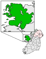
Ceathrú Thaidhg is a Gaeltacht
village and townland
on the Dún Chaocháin peninsula in northwestern County Mayo
, Ireland
. It is within Kilcommon
(Cill Chomáin) parish in the barony of Erris
. Carrowteige is a relatively small townland with an acreage of just 403 acres (1.6 km²).
when the Tír Saile
was created during the 1990s.
In 1841, a road was approved to run from Glenamoy
to Carrowteige. In 1842 the drains for the road were partially opened. By 1843 a report declared that 'the chief part of the draining, forming and sodding of the road from Glenamoy
to Portacloy has been executed'(Ballina Advertiser, March 10, 1843) but by 1845 the road was still far from completed. Eventually in 1846, it was declared completed. There were no bridges on the road. At Muingnabo, the river bed was paved at a ford and remained that way until 1886 when the Annie Brady Bridge was erected. During the Irish Famine and its aftermath, emigration was a way of life from this area. The emigrant and their family parted at this river ford, most never to meet again - 'here indeed were witnessed, scenes of lamentation almost as bad as death, for in most cases in those days it meant separation forever, a living death. Friends and exiles alike carried the painful remembrance of the sad parting' (Corduff, I.F.C. Ms.1242 p. 438). Annie Brady was the wife of the Inspector of Fisheries for the area who witnessed these sad partings and the difficulty in crossing the ford. She raised money to build a bridge at the site, so that the poor of Erris
could travel further with their loved ones. In 1933, a flood carried away the Annie Brady Bridge but it was replaced and is still there today.
Kilcommon
people
have a reputation of protest
which may be in their genes. In the 1950s the roads through Dún Chaocháin were in terrible condition. Having failed to draw the County Council's attention to the matter, Harry Corduff, national schoolteacher refused to pay his road taxes. He was imprisoned in Mountjoy Jail for a week. Public support for his cause was great.
Throughout Erris
until about 1900, the custom was 'in most cottages, the family lived and slept in one room using the others as store rooms. they knew no other kind of house life. In this one room the family retired to sleep, only partially undressed. Often the only furniture in the room was a chair, a couple of small wooden stools, with a cooking pot, a kettle and a tea pot and some cups'(Micks, The Congested Districts Board. p. 92). The biggest industry was that of lace school
s. The Department of Lands and Fisheries took over the lace schools from The Congested Districts Board
about 1923 and formed Gaeltarra Eireann, a semi-state body, to manage them but to curback expenditure the lace school in Carrowteige was closed in 1976. Sewing
and knitting
industry gave most of the employment in both factories and homes over the years.
A Catholic
Church, 'Church of the Immaculate Conception' was built and opened in 1972. Mass here is in the Irish language
.
walks which start and end at Carrowteige village. Maps are available from Comhar Dún Chaocháin Teo
, Sean Scoil in the village. The walks are of various lengths and suitable for individuals and groups. This area would have great appeal to walkers who love wilderness
, high cliffs which overlook Broadhaven Bay
and the wider Atlantic Ocean
, nature and wildlife. They take walkers past some of the Tír Saile sculpture trail, a trail of sculptures to commemmorate over 5,000 years of human habitation in this part of North Mayo.
Gaeltacht
is the Irish language word meaning an Irish-speaking region. In Ireland, the Gaeltacht, or an Ghaeltacht, refers individually to any, or collectively to all, of the districts where the government recognises that the Irish language is the predominant language, that is, the vernacular spoken at home...
village and townland
Townland
A townland or bally is a small geographical division of land used in Ireland. The townland system is of Gaelic origin—most townlands are believed to pre-date the Norman invasion and most have names derived from the Irish language...
on the Dún Chaocháin peninsula in northwestern County Mayo
County Mayo
County Mayo is a county in Ireland. It is located in the West Region and is also part of the province of Connacht. It is named after the village of Mayo, which is now generally known as Mayo Abbey. Mayo County Council is the local authority for the county. The population of the county is 130,552...
, Ireland
Republic of Ireland
Ireland , described as the Republic of Ireland , is a sovereign state in Europe occupying approximately five-sixths of the island of the same name. Its capital is Dublin. Ireland, which had a population of 4.58 million in 2011, is a constitutional republic governed as a parliamentary democracy,...
. It is within Kilcommon
Kilcommon
Kilcommon is a civil parish in Erris, north Mayo consisting of two large peninsulas; Dún Chaocháin and Dún Chiortáin. It consists of 37 townlands, some of which are so remote that they have no inhabitants...
(Cill Chomáin) parish in the barony of Erris
Erris
Erris is a barony in northwestern County Mayo in Ireland consisting of over , much of which is mountainous blanket bog. It has extensive sea coasts along its west and north boundaries. The main towns are Belmullet and Bangor Erris. The name Erris derives from the Irish 'Iar Ros' meaning 'western...
. Carrowteige is a relatively small townland with an acreage of just 403 acres (1.6 km²).
History
Chaocháin, after whom the peninsula is named, was a legendary giant of Celtic sagas (poss 1st century AD) who had only one eye. His image was represented on the slopes of the hills overlooking Sruwaddacon BaySruwaddacon Bay
Sruwaddacon Bay is a tidal estuary which runs through the middle of the Gaeltacht Kilcommon Parish, Erris, North County Mayo; it is of historical importance in Irish legend, an important marine habitat, an E.U. Special Area of Conservation and an E.U...
when the Tír Saile
Erris
Erris is a barony in northwestern County Mayo in Ireland consisting of over , much of which is mountainous blanket bog. It has extensive sea coasts along its west and north boundaries. The main towns are Belmullet and Bangor Erris. The name Erris derives from the Irish 'Iar Ros' meaning 'western...
was created during the 1990s.
In 1841, a road was approved to run from Glenamoy
Glenamoy
Glenamoy is a village in the parish of Kilcommon, Erris in the northern part of County Mayo in Ireland.Glenamoy is a general term for the following townlands:* Bellagelly North...
to Carrowteige. In 1842 the drains for the road were partially opened. By 1843 a report declared that 'the chief part of the draining, forming and sodding of the road from Glenamoy
Glenamoy
Glenamoy is a village in the parish of Kilcommon, Erris in the northern part of County Mayo in Ireland.Glenamoy is a general term for the following townlands:* Bellagelly North...
to Portacloy has been executed'(Ballina Advertiser, March 10, 1843) but by 1845 the road was still far from completed. Eventually in 1846, it was declared completed. There were no bridges on the road. At Muingnabo, the river bed was paved at a ford and remained that way until 1886 when the Annie Brady Bridge was erected. During the Irish Famine and its aftermath, emigration was a way of life from this area. The emigrant and their family parted at this river ford, most never to meet again - 'here indeed were witnessed, scenes of lamentation almost as bad as death, for in most cases in those days it meant separation forever, a living death. Friends and exiles alike carried the painful remembrance of the sad parting' (Corduff, I.F.C. Ms.1242 p. 438). Annie Brady was the wife of the Inspector of Fisheries for the area who witnessed these sad partings and the difficulty in crossing the ford. She raised money to build a bridge at the site, so that the poor of Erris
Erris
Erris is a barony in northwestern County Mayo in Ireland consisting of over , much of which is mountainous blanket bog. It has extensive sea coasts along its west and north boundaries. The main towns are Belmullet and Bangor Erris. The name Erris derives from the Irish 'Iar Ros' meaning 'western...
could travel further with their loved ones. In 1933, a flood carried away the Annie Brady Bridge but it was replaced and is still there today.
Kilcommon
Kilcommon
Kilcommon is a civil parish in Erris, north Mayo consisting of two large peninsulas; Dún Chaocháin and Dún Chiortáin. It consists of 37 townlands, some of which are so remote that they have no inhabitants...
people
Willie Corduff
Willie Corduff is an Irish environmental activist from the farming community of Rossport, parish of Kilcommon, Erris. Corduff's parents first arrived in Rossport in 1947, and reclaimed a farm by hand out of bogland. He became a campaigner against Shells' activities in his local area...
have a reputation of protest
Corrib gas controversy
The Corrib gas controversy concerns plans by Shell E&P Ireland, Statoil Exploration Limited, Vermilion Energy Trust and the Irish government for processing the Corrib gas field through Broadhaven Bay and Sruth Fada Conn Bay in Kilcommon parish, Erris, County Mayo, and objections raised against...
which may be in their genes. In the 1950s the roads through Dún Chaocháin were in terrible condition. Having failed to draw the County Council's attention to the matter, Harry Corduff, national schoolteacher refused to pay his road taxes. He was imprisoned in Mountjoy Jail for a week. Public support for his cause was great.
Throughout Erris
Erris
Erris is a barony in northwestern County Mayo in Ireland consisting of over , much of which is mountainous blanket bog. It has extensive sea coasts along its west and north boundaries. The main towns are Belmullet and Bangor Erris. The name Erris derives from the Irish 'Iar Ros' meaning 'western...
until about 1900, the custom was 'in most cottages, the family lived and slept in one room using the others as store rooms. they knew no other kind of house life. In this one room the family retired to sleep, only partially undressed. Often the only furniture in the room was a chair, a couple of small wooden stools, with a cooking pot, a kettle and a tea pot and some cups'(Micks, The Congested Districts Board. p. 92). The biggest industry was that of lace school
Lace school
Lace schools were common in Britain from the 17th to 19th century to teach lace-making.Lace schools were often the living rooms of small cottages and were known for being overcrowded, badly lit and often unsanitary...
s. The Department of Lands and Fisheries took over the lace schools from The Congested Districts Board
Congested Districts Board for Ireland
The Congested Districts Board for Ireland was established by the Chief Secretary, Arthur Balfour in 1891 to alleviate poverty and "congested" living conditions in the west of Ireland....
about 1923 and formed Gaeltarra Eireann, a semi-state body, to manage them but to curback expenditure the lace school in Carrowteige was closed in 1976. Sewing
Sewing
Sewing is the craft of fastening or attaching objects using stitches made with a needle and thread. Sewing is one of the oldest of the textile arts, arising in the Paleolithic era...
and knitting
Knitting
Knitting is a method by which thread or yarn may be turned into cloth or other fine crafts. Knitted fabric consists of consecutive rows of loops, called stitches. As each row progresses, a new loop is pulled through an existing loop. The active stitches are held on a needle until another loop can...
industry gave most of the employment in both factories and homes over the years.
A Catholic
Catholic
The word catholic comes from the Greek phrase , meaning "on the whole," "according to the whole" or "in general", and is a combination of the Greek words meaning "about" and meaning "whole"...
Church, 'Church of the Immaculate Conception' was built and opened in 1972. Mass here is in the Irish language
Irish language
Irish , also known as Irish Gaelic, is a Goidelic language of the Indo-European language family, originating in Ireland and historically spoken by the Irish people. Irish is now spoken as a first language by a minority of Irish people, as well as being a second language of a larger proportion of...
.
Cliff Walks
There are several looped cliffCliff
In geography and geology, a cliff is a significant vertical, or near vertical, rock exposure. Cliffs are formed as erosion landforms due to the processes of erosion and weathering that produce them. Cliffs are common on coasts, in mountainous areas, escarpments and along rivers. Cliffs are usually...
walks which start and end at Carrowteige village. Maps are available from Comhar Dún Chaocháin Teo
Comhar Dún Chaocháin Teo
Comhar Dún Chaocháin Teo is a community development co-operative based in the peripheral, rural, Gaeltacht, North Mayo area of Ireland. It is registered with the Registry of Friendly Societies and its purpose is to promote the linguistic, cultural, infrastructural, educational and social...
, Sean Scoil in the village. The walks are of various lengths and suitable for individuals and groups. This area would have great appeal to walkers who love wilderness
Wilderness
Wilderness or wildland is a natural environment on Earth that has not been significantly modified by human activity. It may also be defined as: "The most intact, undisturbed wild natural areas left on our planet—those last truly wild places that humans do not control and have not developed with...
, high cliffs which overlook Broadhaven Bay
Broadhaven Bay
Broadhaven Bay is a natural bay of the Atlantic Ocean situated on the northwestern coast of County Mayo, Ireland. The opening of the bay faces northward, stretching between Erris Head on the west side and Kid Island on the east side with approximately 8.6 km between the two sides.It borders...
and the wider Atlantic Ocean
Atlantic Ocean
The Atlantic Ocean is the second-largest of the world's oceanic divisions. With a total area of about , it covers approximately 20% of the Earth's surface and about 26% of its water surface area...
, nature and wildlife. They take walkers past some of the Tír Saile sculpture trail, a trail of sculptures to commemmorate over 5,000 years of human habitation in this part of North Mayo.
See also
- Connacht IrishConnacht IrishConnacht Irish is the dialect of the Irish language spoken in the province of Connacht. Gaeltacht regions in Connacht are found in Counties Mayo and Galway...
- List of towns and villages in Ireland