
Cargo Muchacho Mountains
Encyclopedia
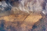
The Cargo Muchacho Mountains are located in the southeast Colorado Desert
in the Lower Colorado River Valley
, in Imperial County, California
in the United States
.
and northwest of the Colorado River
and Yuma, AZ
–Winterhaven, CA
. The range lies south and southeast of the Chocolate Mountains
and east of the Algodones Dunes
. Pilot Knob
is a volcanic plug
formed landmark peak in the range's south.
The mountains are home to the American Girl Mine, and the Golden Bee and Cargo mines. The All American Canal passes through the south of the range.
.
Colorado Desert
California's Colorado Desert is a part of the larger Sonoran Desert, which extends across southwest North America. The Colorado Desert region encompasses approximately , reaching from the Mexican border in the south to the higher-elevation Mojave Desert in the north and from the Colorado River in...
in the Lower Colorado River Valley
Lower Colorado River Valley
The Lower Colorado River Valley is the river region of the lower Colorado River of the southwestern United States in North America that rises in the Rocky Mountains and has its outlet at the Colorado River Delta in the northern Sea of Cortez in northwestern Mexico, between the states of Baja...
, in Imperial County, California
Imperial County, California
Imperial County is a county located in the Imperial Valley, in the far southeast of the U.S. state of California, bordering both Arizona and Mexico. It is part of the El Centro Metropolitan Area, which encompasses all of Imperial County. The population as of 2000 was 142,361. The county seat is the...
in the United States
Southwestern United States
The Southwestern United States is a region defined in different ways by different sources. Broad definitions include nearly a quarter of the United States, including Arizona, California, Colorado, Nevada, New Mexico, Oklahoma, Texas and Utah...
.
Geography
The range lies in a northwest-southeasterly direction, southeast of the Imperial ValleyImperial Valley
The Imperial Valley is an agricultural area of Southern California's Imperial County. It is located in southeastern Southern California, centered around the city of El Centro. Locally, the terms "Imperial Valley" and "Imperial County" are used synonymously. The Valley is bordered between the...
and northwest of the Colorado River
Colorado River
The Colorado River , is a river in the Southwestern United States and northwestern Mexico, approximately long, draining a part of the arid regions on the western slope of the Rocky Mountains. The watershed of the Colorado River covers in parts of seven U.S. states and two Mexican states...
and Yuma, AZ
Yuma, Arizona
Yuma is a city in and the county seat of Yuma County, Arizona, United States. It is located in the southwestern corner of the state, and the population of the city was 77,515 at the 2000 census, with a 2008 Census Bureau estimated population of 90,041....
–Winterhaven, CA
Winterhaven, California
Winterhaven is a census-designated place in Imperial County, California. Winterhaven is located east of Pilot Knob, The population was 394 at the 2010 census, down from 529 at the 2000 census. It is part of the 'El Centro, California Metropolitan Statistical Area'...
. The range lies south and southeast of the Chocolate Mountains
Chocolate Mountains
The Chocolate Mountains of California are located in Imperial County and Riverside County in the Colorado Desert in Southern California. The mountains stretch more than 60 miles in a northwest to southeast direction, and are located east of the Salton Sea and south and west of the Chuckwalla...
and east of the Algodones Dunes
Algodones Dunes
The Algodones Dunes is a large erg located in the southeastern portion of the U.S. state of California, near the border with Arizona and the Mexican state of Baja California. The field is approximately 45 miles long by 6 miles wide and extends along a northwest-southeast line that correlates to...
. Pilot Knob
Pilot Knob (Imperial County, California)
Pilot Knob is a peak in Imperial County, California.Pilot Knob is located southeast of Ogilby, It rises to an elevation of...
is a volcanic plug
Volcanic plug
A volcanic plug, also called a volcanic neck or lava neck, is a volcanic landform created when magma hardens within a vent on an active volcano. When forming, a plug can cause an extreme build-up of pressure if volatile-charged magma is trapped beneath it, and this can sometimes lead to an...
formed landmark peak in the range's south.
The mountains are home to the American Girl Mine, and the Golden Bee and Cargo mines. The All American Canal passes through the south of the range.
.