
.gif)
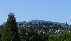
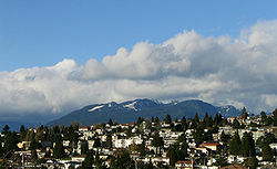
Capitol Hill (Burnaby)
Encyclopedia
British Columbia
British Columbia is the westernmost of Canada's provinces and is known for its natural beauty, as reflected in its Latin motto, Splendor sine occasu . Its name was chosen by Queen Victoria in 1858...
, Canada
Canada
Canada is a North American country consisting of ten provinces and three territories. Located in the northern part of the continent, it extends from the Atlantic Ocean in the east to the Pacific Ocean in the west, and northward into the Arctic Ocean...
, and also is the name of the neighbourhood spanning the summit of the hill. Standing on the north side of Hastings Street
Hastings Street (Vancouver)
Hastings Street is one of the most important east-west traffic corridors in the cities of Vancouver and Burnaby, British Columbia, Canada, and used to be a part of the decommissioned Highway 7A...
and bounded by Willingdon Avenue to the west and Fell Avenue in the east, this neighbourhood is known for its extensive Italian
Italian people
The Italian people are an ethnic group that share a common Italian culture, ancestry and speak the Italian language as a mother tongue. Within Italy, Italians are defined by citizenship, regardless of ancestry or country of residence , and are distinguished from people...
and Croatian expat
Expatriate
An expatriate is a person temporarily or permanently residing in a country and culture other than that of the person's upbringing...
communities as well as being a student area in connection with the nearby Simon Fraser University
Simon Fraser University
Simon Fraser University is a Canadian public research university in British Columbia with its main campus on Burnaby Mountain in Burnaby, and satellite campuses in Vancouver and Surrey. The main campus in Burnaby, located from downtown Vancouver, was established in 1965 and has more than 34,000...
.

Housing
There are several apartment buildings in the area, mostly along Hastings Street. Although the majority of housing is single-family, the size and value of land increases towards the top of the hill as does the view of downtown Vancouver and the water.Parks and activities
A walking trail constituting part of Trans Canada TrailTrans Canada Trail
The Trans Canada Trail is a proposed corridor in Canada. The creation of the trail was announced as part of Canada's 125th anniversary celebrations in 1992. It is expected that when complete, it will be the longest recreational trail in the world...
skirts the northern flank of the hill.
Transport and amenities
The neighbourhood is served by a bus providing connections with the popular HeightsBurnaby Heights
Burnaby Heights, officially known as Vancouver Heights and commonly referred to as The Heights, is a quiet, prestigious residential neighbourhood in North Burnaby between Boundary Road to the west, Gamma Avenue to the east and bounded by Hastings Street to the south...
shopping district along Hastings Street, Eileen Dailly swimming pool
Swimming pool
A swimming pool, swimming bath, wading pool, or simply a pool, is a container filled with water intended for swimming or water-based recreation. There are many standard sizes; the largest is the Olympic-size swimming pool...
, the McGill branch of Burnaby Public Library
Burnaby Public Library
Burnaby Public Library or BPL is a public library that serves Burnaby, British Columbia and the surrounding Lower Mainland. It allows users to borrow books, videos, dvds and magazines.-History:...
and Brentwood Mall to the south.
Scenic viewpoints
A park near the end of Hythe Ave N., near Hythe's intersection with Cambridge, offers panoramic views of East VancouverEast Vancouver
East Vancouver is a region within the City of Vancouver, British Columbia, Canada. Geographically, East Vancouver is bordered to the north by Burrard Inlet, to the south by the Fraser River, and to the east by the city of Burnaby...
, Downtown Vancouver, Burrard Inlet
Burrard Inlet
Burrard Inlet is a relatively shallow-sided coastal fjord in southwestern British Columbia, Canada. Formed during the last Ice Age, it separates the City of Vancouver and the rest of the low-lying Burrard Peninsula from the slopes of the North Shore Mountains, home to the communities of West...
with both the Lions' Gate Bridge
Lions' Gate Bridge
The Lions Gate Bridge, officially known as the First Narrows Bridge, is a suspension bridge that crosses the first narrows of Burrard Inlet and connects the City of Vancouver, British Columbia, to the North Shore municipalities of the District of North Vancouver, the City of North Vancouver, and...
and the Second Narrows Bridge (Ironworkers Memorial Second Narrows Crossing
Ironworkers Memorial Second Narrows Crossing
The Ironworkers Memorial Second Narrows Crossing, also called the Ironworkers Memorial Bridge, is the second bridge constructed at the Second Narrows of Burrard Inlet in Vancouver, British Columbia, Canada...
), the North Shore Mountains
North Shore Mountains
The North Shore Mountains are a mountain range overlooking Vancouver in British Columbia, Canada. Their southernmost peaks are visible from most areas in Vancouver and form a distinctive backdrop for the city....
including The Lions
The Lions (Peaks)
The Lions are a pair of pointed peaks along the North Shore Mountains in Metro Vancouver, British Columbia, Canada. They can be seen from much of the Greater Vancouver area, as far as Robert Burnaby Park in East Burnaby, south to parts of Surrey, and from the west on the Howe Sound Islands and the...
, Bowen Island
Bowen Island
Bowen Island, British Columbia, is an island municipality in Howe Sound, is part of the Greater Vancouver Regional District, and is an island included within the jurisdiction of the Islands Trust . Approximately 6 km wide by 12 km long, the island at its closest point is about 2 km...
and Vancouver Island
Vancouver Island
Vancouver Island is a large island in British Columbia, Canada. It is one of several North American locations named after George Vancouver, the British Royal Navy officer who explored the Pacific Northwest coast of North America between 1791 and 1794...
and is a favourite gathering spot for the locals to enjoy spectacular sunsets and watch the annual fireworks over English Bay
English Bay, Vancouver
English Bay is located in Vancouver, British Columbia, Canada, west of the downtown peninsula, which separates the bay from Burrard Inlet connecting to the northwest, and False Creek to the southeast. English Bay Beach, near the city's West End residential neighbourhood, is the most popular...
in late July and early August. To the east, Capitol Hill boasts spectacular views of Indian Arm
Indian Arm
Indian Arm is a steep-sided glacial fjord adjacent to the city of Vancouver in southwestern British Columbia. Formed during the last Ice Age, it extends due north from Burrard Inlet, between the communities of Belcarra and the District of North Vancouver , then on into mountainous wilderness...
, Burnaby Mountain
Burnaby Mountain
Burnaby Mountain, elev. , is a low, forested mountain in the city of Burnaby, British Columbia, overlooking the upper arms of Burrard Inlet. It is the location of Simon Fraser University, the Discovery Park research community, and the System Control Tower of BC Hydro and a new complex of...
and Mount Baker
Mount Baker
Mount Baker , also known as Koma Kulshan or simply Kulshan, is an active glaciated andesitic stratovolcano in the Cascade Volcanic Arc and the North Cascades of Washington State in the United States. It is the second-most active volcano in the range after Mount Saint Helens...
.