
Cape Otway
Encyclopedia
Cape Otway is a cape in south Victoria
, Australia
on the Great Ocean Road
; much of the area is enclosed in the Otway National Park
.
people; evidence of their campsites is contained in the midden
s throughout the region. The Cape was discovered by Europeans when Lieutenant James Grant
surveyed the Victorian coast in the Lady Nelson
. The government reserved the tip of the cape as the site for a lighthouse. Access to the site was difficult, it was eventually reached overland and construction of the Cape Otway Lightstation began in 1846 from stone quarried at the Parker River
.
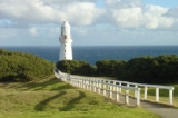
The light was first lit in 1848 using a first order Fresnel lens
; it was the second lighthouse completed on mainland Australia and it remains the oldest surviving lighthouse in mainland Australia. It was decommissioned in January 1994 after being the longest continuous operating light on the Australian mainland. At the keeper's cottages of Apollo Bay, accommodation is available in two double studios or in the head keeper's cottage that will sleep groups ranging from two to sixteen people. A telegraph station
was added to the site when Tasmania
was connected to the mainland by a submarine telegraph line from Cape Otway to Launceston
in 1859. Parts of the Cape were also open to free settlers.
Eight ships were wrecked along the coast of Cape Otway. These included the Marie (1851), Sacramento (1853), Shomberg (1856), Loch Ard
(1878), Joseph H. Scammell (May 1891), Fiji (September 1891) and the Casino in 1932. The first American vessel sunk during World War II, the SS City of Rayville
, was also sunk off the Cape by a German mine. Following this, the Americans built a radar bunker on the cape in 1942; it is now open to the public.
The lightstation was decommissioned in January 1994 after being the longest continuous operating light on the Australian mainland. It has been replaced by a low powered solar light in front of the original tower whose focal plane is at 73 m above sea level. Its light characteristic is three white flashes every 18 seconds.
Victoria (Australia)
Victoria is the second most populous state in Australia. Geographically the smallest mainland state, Victoria is bordered by New South Wales, South Australia, and Tasmania on Boundary Islet to the north, west and south respectively....
, Australia
Australia
Australia , officially the Commonwealth of Australia, is a country in the Southern Hemisphere comprising the mainland of the Australian continent, the island of Tasmania, and numerous smaller islands in the Indian and Pacific Oceans. It is the world's sixth-largest country by total area...
on the Great Ocean Road
Great Ocean Road
The Great Ocean Road is a stretch of road along the south-eastern coast of Australia between the Victorian cities of Torquay and Warrnambool. The road was built by returned soldiers between 1919 and 1932, and is the world's largest war memorial; dedicated to casualties of World War I...
; much of the area is enclosed in the Otway National Park
Otway National Park
The Great Otway National Park is a national park in Victoria , 162 km southwest of Melbourne. It contains a diverse range of landscapes and vegetation types.-History:...
.
History
Cape Otway was originally inhabited by the GadubanudGadubanud
The Gadubanud people occupied the rainforest plateau and rugged coastline of Cape Otway in Western Victoria covering the present towns of Lorne and Apollo Bay. The Gellibrand and Barwon Rivers are likely territorial borders with the Wada wurrung to the north east, Gulidjan to the north and Girai...
people; evidence of their campsites is contained in the midden
Midden
A midden, is an old dump for domestic waste which may consist of animal bone, human excrement, botanical material, vermin, shells, sherds, lithics , and other artifacts and ecofacts associated with past human occupation...
s throughout the region. The Cape was discovered by Europeans when Lieutenant James Grant
James Grant (navigator)
James Grant was a British Royal Navy officer and navigator in the early nineteenth century. He made several voyages to Australia and Tasmania, and was the first to map parts of the south coast of Australia.-Early life:...
surveyed the Victorian coast in the Lady Nelson
Lady Nelson
The Royal Navy purchased Lady Nelson in 1799. She spent her career exploring the coast of Australia in the early years of the 19th century. She was the first known vessel to sail eastward through Bass Strait, the first to sail along the South coast of Victoria, as well as the first to enter Port...
. The government reserved the tip of the cape as the site for a lighthouse. Access to the site was difficult, it was eventually reached overland and construction of the Cape Otway Lightstation began in 1846 from stone quarried at the Parker River
Parker River
The Parker River is a river in southwestern Victoria, Australia. It lies wholly within Port Campbell National Park in the Otway Ranges and enters Bass Strait near Cape Otway....
.
The light was first lit in 1848 using a first order Fresnel lens
Fresnel lens
A Fresnel lens is a type of lens originally developed by French physicist Augustin-Jean Fresnel for lighthouses.The design allows the construction of lenses of large aperture and short focal length without the mass and volume of material that would be required by a lens of conventional design...
; it was the second lighthouse completed on mainland Australia and it remains the oldest surviving lighthouse in mainland Australia. It was decommissioned in January 1994 after being the longest continuous operating light on the Australian mainland. At the keeper's cottages of Apollo Bay, accommodation is available in two double studios or in the head keeper's cottage that will sleep groups ranging from two to sixteen people. A telegraph station
Australian telegraphic history
Australia was a relatively early adopter of telegraph technology in the middle nineteenth century, despite its low population densities and the difficult conditions sometimes encountered in laying lines. From 1858 onwards, the major capitals were progressively linked, culminating in the addition...
was added to the site when Tasmania
Tasmania
Tasmania is an Australian island and state. It is south of the continent, separated by Bass Strait. The state includes the island of Tasmania—the 26th largest island in the world—and the surrounding islands. The state has a population of 507,626 , of whom almost half reside in the greater Hobart...
was connected to the mainland by a submarine telegraph line from Cape Otway to Launceston
Launceston, Tasmania
Launceston is a city in the north of the state of Tasmania, Australia at the junction of the North Esk and South Esk rivers where they become the Tamar River. Launceston is the second largest city in Tasmania after the state capital Hobart...
in 1859. Parts of the Cape were also open to free settlers.
Eight ships were wrecked along the coast of Cape Otway. These included the Marie (1851), Sacramento (1853), Shomberg (1856), Loch Ard
Loch Ard (ship)
The Loch Ard was a ship which was wrecked at Muton bird Island just off the Shipwreck Coast of Victoria, Australia in 1878. The name was drawn from Loch Ard, a lake which lies to the west of the village of Aberfoyle, and to the east of Loch Lomond...
(1878), Joseph H. Scammell (May 1891), Fiji (September 1891) and the Casino in 1932. The first American vessel sunk during World War II, the SS City of Rayville
SS City of Rayville
The SS City of Rayville, also referred to as the MV and/or MS City of Rayville was a 5883-ton American steamship. She was built in 1920 by Oscar Daniels & Co. of Tampa, Florida.- Sinking :...
, was also sunk off the Cape by a German mine. Following this, the Americans built a radar bunker on the cape in 1942; it is now open to the public.
The lightstation was decommissioned in January 1994 after being the longest continuous operating light on the Australian mainland. It has been replaced by a low powered solar light in front of the original tower whose focal plane is at 73 m above sea level. Its light characteristic is three white flashes every 18 seconds.