
Cape Chidley Islands
Encyclopedia
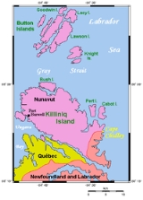
The Cape Chidley Islands are members of the Canadian Arctic Archipelago
in the territory of Nunavut
. They are located in the Labrador Sea
at the south end of the entrance to the Hudson Strait
, north of Killiniq Island
's Cape Chidley
, and separated from Killiniq Island by the MacGregor Strait.
Cabot Island is the eastern of the two islands and is 2 mi (3.2 km) long. It has two summits, the northern one being 401 m (1,315.6 ft) above sea level
, and the southern one being 325 m (1,066.3 ft) high.
Pert Island is the smaller of the two islands and is located 0.5 mi (0.80467 km) mile to the west. Its highest point is 385 m (1,263.1 ft) above sea level
. Port Burwell lies 20 km (12.4 mi) west of Pert Island.
Canadian Arctic Archipelago
The Canadian Arctic Archipelago, also known as the Arctic Archipelago, is a Canadian archipelago north of the Canadian mainland in the Arctic...
in the territory of Nunavut
Nunavut
Nunavut is the largest and newest federal territory of Canada; it was separated officially from the Northwest Territories on April 1, 1999, via the Nunavut Act and the Nunavut Land Claims Agreement Act, though the actual boundaries had been established in 1993...
. They are located in the Labrador Sea
Labrador Sea
The Labrador Sea is an arm of the North Atlantic Ocean between the Labrador Peninsula and Greenland. The sea is flanked by continental shelves to the southwest, northwest, and northeast. It connects to the north with Baffin Bay through the Davis Strait...
at the south end of the entrance to the Hudson Strait
Hudson Strait
Hudson Strait links the Atlantic Ocean to Hudson Bay in Canada. It lies between Baffin Island and the northern coast of Quebec, its eastern entrance marked by Cape Chidley and Resolution Island. It is long...
, north of Killiniq Island
Killiniq Island
Killiniq Island is a small, remote island in northeastern Canada. Located at the extreme northern tip of Labrador between Ungava Bay and the Labrador Sea, it is notable in that it contains the only land border between Nunavut territory and the province of Newfoundland and Labrador...
's Cape Chidley
Cape Chidley
Cape Chidley is a headland located on the eastern shore of Killiniq Island, Canada at the northeastern tip of the Labrador Peninsula.-Cape Chidley:...
, and separated from Killiniq Island by the MacGregor Strait.
Cabot Island is the eastern of the two islands and is 2 mi (3.2 km) long. It has two summits, the northern one being 401 m (1,315.6 ft) above sea level
Sea level
Mean sea level is a measure of the average height of the ocean's surface ; used as a standard in reckoning land elevation...
, and the southern one being 325 m (1,066.3 ft) high.
Pert Island is the smaller of the two islands and is located 0.5 mi (0.80467 km) mile to the west. Its highest point is 385 m (1,263.1 ft) above sea level
Sea level
Mean sea level is a measure of the average height of the ocean's surface ; used as a standard in reckoning land elevation...
. Port Burwell lies 20 km (12.4 mi) west of Pert Island.