

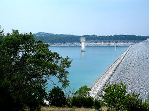
Canyon Dam
Encyclopedia
Texas
Texas is the second largest U.S. state by both area and population, and the largest state by area in the contiguous United States.The name, based on the Caddo word "Tejas" meaning "friends" or "allies", was applied by the Spanish to the Caddo themselves and to the region of their settlement in...
is a rolled-earth dam
Dam
A dam is a barrier that impounds water or underground streams. Dams generally serve the primary purpose of retaining water, while other structures such as floodgates or levees are used to manage or prevent water flow into specific land regions. Hydropower and pumped-storage hydroelectricity are...
on the Guadalupe River
Guadalupe River (Texas)
The Guadalupe River runs from Kerr County, Texas to San Antonio Bay on the Gulf of Mexico. The river is a popular destination for rafters and canoers. Larger cities along the river include New Braunfels, Kerrville, Seguin, Gonzales, Cuero, and Victoria...
in the Hill Country
Texas Hill Country
The Texas Hill Country is a vernacular term applied to a region of Central Texas featuring tall rugged hills consisting of thin layers of soil atop limestone or granite. It also includes the Llano Uplift and the second largest granite monadnock in the United States, Enchanted Rock, which is located...
. The water impounded by the dam forms Canyon Lake
Canyon Lake (Texas)
Canyon Lake is a reservoir on the Guadalupe River in the Texas Hill Country in the United States. Canyon Lake is a U.S. Army Corps of Engineers reservoir formed on the Guadalupe River in Comal County by Canyon Dam, which is located about sixteen miles northwest of New Braunfels. The dam, lake,...
.
Geography
The dam is located at 29.86872, -98.19741 (WGS 84World Geodetic System
The World Geodetic System is a standard for use in cartography, geodesy, and navigation. It comprises a standard coordinate frame for the Earth, a standard spheroidal reference surface for raw altitude data, and a gravitational equipotential surface that defines the nominal sea level.The latest...
datum); this is 36 miles (58 km) northeast of San Antonio
San Antonio, Texas
San Antonio is the seventh-largest city in the United States of America and the second-largest city within the state of Texas, with a population of 1.33 million. Located in the American Southwest and the south–central part of Texas, the city serves as the seat of Bexar County. In 2011,...
and 38 miles (61 km) southwest of Austin
Austin, Texas
Austin is the capital city of the U.S. state of :Texas and the seat of Travis County. Located in Central Texas on the eastern edge of the American Southwest, it is the fourth-largest city in Texas and the 14th most populous city in the United States. It was the third-fastest-growing large city in...
.
The dam is 6,830 feet (2,082 m) long, across a narrow section of the Guadalupe River valley
Valley
In geology, a valley or dale is a depression with predominant extent in one direction. A very deep river valley may be called a canyon or gorge.The terms U-shaped and V-shaped are descriptive terms of geography to characterize the form of valleys...
. The top of the dam is 974 feet (297 m) above sea level
Sea level
Mean sea level is a measure of the average height of the ocean's surface ; used as a standard in reckoning land elevation...
, or 224 feet (68 m) above the riverbed. A spillway
Spillway
A spillway is a structure used to provide the controlled release of flows from a dam or levee into a downstream area, typically being the river that was dammed. In the UK they may be known as overflow channels. Spillways release floods so that the water does not overtop and damage or even destroy...
, located south of the dam, protects the dam by releasing water when the lake level rises to 943 feet (287 m) above sea level.
The dam is located near the Balcones Escarpment
Balcones Fault
The Balcones Fault Zone is a tensional structural system in Texas that runs approximately from the southwest part of the state near Del Rio to the north central region near Waco along Interstate 35. The Balcones Fault zone is made up of many smaller features, including normal faults, grabens, and...
. The rocky canyon
Canyon
A canyon or gorge is a deep ravine between cliffs often carved from the landscape by a river. Rivers have a natural tendency to reach a baseline elevation, which is the same elevation as the body of water it will eventually drain into. This forms a canyon. Most canyons were formed by a process of...
s to the west of the escarpment can carry more water than the riverbeds of the plain
Plain
In geography, a plain is land with relatively low relief, that is flat or gently rolling. Prairies and steppes are types of plains, and the archetype for a plain is often thought of as a grassland, but plains in their natural state may also be covered in shrublands, woodland and forest, or...
s to the east; this has caused problems with flash flooding
Flash flood
A flash flood is a rapid flooding of geomorphic low-lying areas—washes, rivers, dry lakes and basins. It may be caused by heavy rain associated with a storm, hurricane, or tropical storm or meltwater from ice or snow flowing over ice sheets or snowfields...
in cities and towns east of the escarpment.
History
After major floods on the Guadalupe River in 1936 and 1938, state and community leaders pressured the federal governmentFederal government of the United States
The federal government of the United States is the national government of the constitutional republic of fifty states that is the United States of America. The federal government comprises three distinct branches of government: a legislative, an executive and a judiciary. These branches and...
to help control flooding of the river. Congress
United States Congress
The United States Congress is the bicameral legislature of the federal government of the United States, consisting of the Senate and the House of Representatives. The Congress meets in the United States Capitol in Washington, D.C....
authorized initial funds for construction of a dam in the Rivers and Harbors Act of 1945; final construction approval came in the Flood Control Act of 1954.
Construction of Canyon Dam began in 1958 to provide both flood control and water conservation. Impoundment of the lake began in 1964, and the lake was filled to its conservation level in 1968. The dam was built by the Tencon Corporation of Fort Worth, Texas. The U.S. Army Corp of Engineers
United States Army Corps of Engineers
The United States Army Corps of Engineers is a federal agency and a major Army command made up of some 38,000 civilian and military personnel, making it the world's largest public engineering, design and construction management agency...
controls the physical operations; and water in the lake is managed by the Guadalupe-Blanco River Authority
Guadalupe-Blanco River Authority
The Guadalupe-Blanco River Authority or GBRA was formed in 1933 by the Texas legislature. Its main concerns are water supply and water conservation in the Guadalupe River Basin, which includes the Blanco, Comal, and San Marcos rivers. The authority extends over ten counties...
.
External links
- Canyon Lake information from the U.S. Army Corps of Engineers
- Guadalupe-Blanco River Authority
- Canyon Lake information from http://www.edwardsaquifer.net/
- Canyon Lake levels and Canyon Dam release rates