
California State Route 61
Encyclopedia
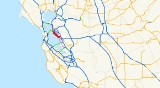
State Route 61 is a California
, United States
, highway which runs through Alameda
and along the Oakland International Airport
. The western terminus is with State Route 260 at Webster Street in Alameda, and it runs along east Central Avenue and Encinal Avenue until reaching Broadway. It goes south along Broadway, then east along Otis Drive until crossing off the island of Alameda on the Bay Farm Island Bridge. It then follows Dolittle Drive near the Oakland International Airport until it reaches State Route 112 at Davis Street in San Leandro
.
As legislatively defined, Route 61 extends as far north as Albany and as far south as the Dumbarton Bridge
's east approach. Only the portion between Routes 260 and 112 is presently constructed; the unbuilt remainder of the route exists today either as open San Francisco Bay
or wetlands. This route would likely have sat atop landfill; as public opinion shifted against filling in the bay, completing the remaining portions of Route 61 also fell out of favor. Route 87
is another highway once proposed to traverse present-day wetlands and open water.
Routes 112 and 260 are "hidden" routes that, despite having legal descriptions separate from Route 61, are currently signed as part of Route 61. Route 112 runs as Davis Street to State Route 185
(East 14th Street) in San Leandro. Route 260 goes to (but does not intersect with) Interstate 880 in Oakland
through the Posey and Webster underwater tunnel
s.
.
The route begins at SR 185
in San Leandro
. It then interchanges with Interstate 880. It then continues northward and enters the city of Oakland
for a short while and crosses the San Leandro Bay
via a drawbridge. It then winds its way northward through the city of Alameda
. It then goes under the Oakland Estuary
via the Posey and Webster Street Tubes
; it then reenters the city of Oakland, where it meets its north end at 7th Street.
The entire route is in Alameda County
.
{| class=wikitable
!Location
!Postmile
!Destinations
!Notes
|-
|rowspan=4|San Leandro
|1.78Indicates that the postmile represents the distance along SR 112 rather than SR 61.
|Callan Avenue
|Continuation beyond SR 185
|-
|1.78
|
|East end of unsigned SR 112
|-
|0.60
|
|Interchange
|-
|R0.00
14.80
|Davis Street, Doolittle Drive
|West end of unsigned SR 112
|-
|Oakland
|16.07
| 98th Avenue to I-880 – Oakland International Airport
|Interchange
|-
|rowspan=8|Alameda
|18.55
|colspan=2 align=center|Bay Farm Island Bridge over San Leandro Bay
|-
|19.44
|Otis Street, Broadway
|
|-
|19.84
|Broadway, Encinal Avenue
|
|-
|21.27
|Sherman Street, Central Avenue
|
|-
|21.97
0.00Indicates that the postmile represents the distance along SR 260 rather than SR 61.
|Central Avenue, Webster Street
|South end of unsigned SR 260
|-
|R0.86
|Wilver "Willie" Stargell Avenue
|At-grade intersection
; former southbound exit and entrance interchange; formerly Mariner Square Drive
|-bgcolor=#ffdddd
|R0.86
|Constitution Way, Marina Village Parkway
|Interchange; southbound left exit and northbound entrance
|-
|rowspan=2|R1.12
R1.20
|rowspan=2 colspan=2 align=center|Posey and Webster Street Tubes
under Oakland Estuary
|-
|rowspan=3|Oakland
|-
|R1.92
|.svg.png)
 7th Street to I-880 (Nimitz Freeway, to I-980 east) – San Francisco
7th Street to I-880 (Nimitz Freeway, to I-980 east) – San Francisco
, San Jose
, Jack London Square
|North end of unsigned SR 260
|-
|R1.92
|Harrison Street
|Continuation beyond 7th Street
California
California is a state located on the West Coast of the United States. It is by far the most populous U.S. state, and the third-largest by land area...
, United States
United States
The United States of America is a federal constitutional republic comprising fifty states and a federal district...
, highway which runs through Alameda
Alameda, California
Alameda is a city in Alameda County, California, United States. It is located on Alameda Island and Bay Farm Island, and is adjacent to Oakland in the San Francisco Bay. The Bay Farm Island portion of the city is adjacent to the Oakland International Airport. At the 2010 census, the city had a...
and along the Oakland International Airport
Oakland International Airport
Oakland International Airport , also known as Metropolitan Oakland International Airport, is a public airport located south of the central business district of Oakland, a city in Alameda County, California, United States...
. The western terminus is with State Route 260 at Webster Street in Alameda, and it runs along east Central Avenue and Encinal Avenue until reaching Broadway. It goes south along Broadway, then east along Otis Drive until crossing off the island of Alameda on the Bay Farm Island Bridge. It then follows Dolittle Drive near the Oakland International Airport until it reaches State Route 112 at Davis Street in San Leandro
San Leandro, California
San Leandro is a city in Alameda County, California, United States. It is considered a suburb of Oakland and San Francisco. The population was 84,950 as of 2010 census. The climate of the city is mild throughout the year.-Geography and water resources:...
.
As legislatively defined, Route 61 extends as far north as Albany and as far south as the Dumbarton Bridge
Dumbarton Bridge (California)
The Dumbarton Bridge is the southernmost of the highway bridges that span the San Francisco Bay in California. Carrying over 81,000 vehicles daily, it is also the shortest bridge across San Francisco Bay at 1.63 miles...
's east approach. Only the portion between Routes 260 and 112 is presently constructed; the unbuilt remainder of the route exists today either as open San Francisco Bay
San Francisco Bay
San Francisco Bay is a shallow, productive estuary through which water draining from approximately forty percent of California, flowing in the Sacramento and San Joaquin rivers from the Sierra Nevada mountains, enters the Pacific Ocean...
or wetlands. This route would likely have sat atop landfill; as public opinion shifted against filling in the bay, completing the remaining portions of Route 61 also fell out of favor. Route 87
California State Route 87
State Route 87 , locally called Highway 87 or the Guadalupe Freeway, is a north–south state highway entirely within San Jose, California, United States. Its name was changed from Guadalupe Parkway in 2004 after its entire constructed length was upgraded to a freeway...
is another highway once proposed to traverse present-day wetlands and open water.
Routes 112 and 260 are "hidden" routes that, despite having legal descriptions separate from Route 61, are currently signed as part of Route 61. Route 112 runs as Davis Street to State Route 185
California State Route 185
State Route 185 is a state highway in the San Francisco Bay Area of the U.S. state of California. It runs along sections of Mission Boulevard in Hayward, East 14th Street in San Leandro and International Boulevard in Oakland.-Route description:...
(East 14th Street) in San Leandro. Route 260 goes to (but does not intersect with) Interstate 880 in Oakland
Oakland, California
Oakland is a major West Coast port city on San Francisco Bay in the U.S. state of California. It is the eighth-largest city in the state with a 2010 population of 390,724...
through the Posey and Webster underwater tunnel
Tunnel
A tunnel is an underground passageway, completely enclosed except for openings for egress, commonly at each end.A tunnel may be for foot or vehicular road traffic, for rail traffic, or for a canal. Some tunnels are aqueducts to supply water for consumption or for hydroelectric stations or are sewers...
s.
Route description
Route 61 is part of the California Freeway and Expressway SystemCalifornia Freeway and Expressway System
The California Freeway and Expressway System is a system of existing or planned freeways and expressways in the U.S. state of California. It is defined by the Streets and Highways Code.-List of roads in the system:*State Route 1 *State Route 2...
.
The route begins at SR 185
California State Route 185
State Route 185 is a state highway in the San Francisco Bay Area of the U.S. state of California. It runs along sections of Mission Boulevard in Hayward, East 14th Street in San Leandro and International Boulevard in Oakland.-Route description:...
in San Leandro
San Leandro, California
San Leandro is a city in Alameda County, California, United States. It is considered a suburb of Oakland and San Francisco. The population was 84,950 as of 2010 census. The climate of the city is mild throughout the year.-Geography and water resources:...
. It then interchanges with Interstate 880. It then continues northward and enters the city of Oakland
Oakland, California
Oakland is a major West Coast port city on San Francisco Bay in the U.S. state of California. It is the eighth-largest city in the state with a 2010 population of 390,724...
for a short while and crosses the San Leandro Bay
San Leandro Bay
San Leandro Bay is a body of water in the San Francisco Bay. It is connected to the Oakland Estuary today, but was originally separated by land which formerly connected Alameda with Oakland. It is located along the east of the Oakland International Airport and Bay Farm Island. The principal...
via a drawbridge. It then winds its way northward through the city of Alameda
Alameda, California
Alameda is a city in Alameda County, California, United States. It is located on Alameda Island and Bay Farm Island, and is adjacent to Oakland in the San Francisco Bay. The Bay Farm Island portion of the city is adjacent to the Oakland International Airport. At the 2010 census, the city had a...
. It then goes under the Oakland Estuary
Oakland Estuary
The Oakland Estuary is the body of water separating the cities of Oakland and Alameda, California, in the San Francisco Bay Area. On its western end it connects to San Francisco Bay, while its eastern end connects to San Leandro Bay.-Crossings:...
via the Posey and Webster Street Tubes
Posey and Webster Street Tubes
Methods Used in the Construction of TwelvePre-cast Concrete Segments for the Alameda County, California, EstuarySubway, in American Society of Civil Engineers, Proceedings, 53 :2675-2692 S. W...
; it then reenters the city of Oakland, where it meets its north end at 7th Street.
Major intersections
- Note: Except where prefixed with a letter, postmiles were measured in 1964, based on the alignment as it existed at that time, and do not necessarily reflect current mileage.
The entire route is in Alameda County
Alameda County, California
Alameda County is a county in the U.S. state of California. It occupies most of the East Bay region of the San Francisco Bay Area. As of the 2010 census it had a population of 1,510,271, making it the 7th most populous county in the state...
.
{| class=wikitable
!Location
!Postmile
!Destinations
!Notes
|-
|rowspan=4|San Leandro
San Leandro, California
San Leandro is a city in Alameda County, California, United States. It is considered a suburb of Oakland and San Francisco. The population was 84,950 as of 2010 census. The climate of the city is mild throughout the year.-Geography and water resources:...
|1.78Indicates that the postmile represents the distance along SR 112 rather than SR 61.
|Callan Avenue
|Continuation beyond SR 185
|-
|1.78
|
|East end of unsigned SR 112
|-
|0.60
|
|Interchange
|-
|R0.00
14.80
|Davis Street, Doolittle Drive
|West end of unsigned SR 112
|-
|Oakland
Oakland, California
Oakland is a major West Coast port city on San Francisco Bay in the U.S. state of California. It is the eighth-largest city in the state with a 2010 population of 390,724...
|16.07
| 98th Avenue to I-880 – Oakland International Airport
Oakland International Airport
Oakland International Airport , also known as Metropolitan Oakland International Airport, is a public airport located south of the central business district of Oakland, a city in Alameda County, California, United States...
|Interchange
|-
|rowspan=8|Alameda
Alameda, California
Alameda is a city in Alameda County, California, United States. It is located on Alameda Island and Bay Farm Island, and is adjacent to Oakland in the San Francisco Bay. The Bay Farm Island portion of the city is adjacent to the Oakland International Airport. At the 2010 census, the city had a...
|18.55
|colspan=2 align=center|Bay Farm Island Bridge over San Leandro Bay
San Leandro Bay
San Leandro Bay is a body of water in the San Francisco Bay. It is connected to the Oakland Estuary today, but was originally separated by land which formerly connected Alameda with Oakland. It is located along the east of the Oakland International Airport and Bay Farm Island. The principal...
|-
|19.44
|Otis Street, Broadway
|
|-
|19.84
|Broadway, Encinal Avenue
|
|-
|21.27
|Sherman Street, Central Avenue
|
|-
|21.97
0.00Indicates that the postmile represents the distance along SR 260 rather than SR 61.
|Central Avenue, Webster Street
|South end of unsigned SR 260
|-
|R0.86
|Wilver "Willie" Stargell Avenue
|At-grade intersection
At-grade intersection
An at-grade intersection is a junction at which two or more transport axes cross at the same level .-Traffic management:With areas of high or fast traffic, an at-grade intersection normally requires a traffic control device such as a stop sign, traffic light or railway signal to manage conflicting...
; former southbound exit and entrance interchange; formerly Mariner Square Drive
|-bgcolor=#ffdddd
|R0.86
|Constitution Way, Marina Village Parkway
|Interchange; southbound left exit and northbound entrance
|-
|rowspan=2|R1.12
R1.20
|rowspan=2 colspan=2 align=center|Posey and Webster Street Tubes
Posey and Webster Street Tubes
Methods Used in the Construction of TwelvePre-cast Concrete Segments for the Alameda County, California, EstuarySubway, in American Society of Civil Engineers, Proceedings, 53 :2675-2692 S. W...
under Oakland Estuary
Oakland Estuary
The Oakland Estuary is the body of water separating the cities of Oakland and Alameda, California, in the San Francisco Bay Area. On its western end it connects to San Francisco Bay, while its eastern end connects to San Leandro Bay.-Crossings:...
|-
|rowspan=3|Oakland
Oakland, California
Oakland is a major West Coast port city on San Francisco Bay in the U.S. state of California. It is the eighth-largest city in the state with a 2010 population of 390,724...
|-
|R1.92
|
San Francisco, California
San Francisco , officially the City and County of San Francisco, is the financial, cultural, and transportation center of the San Francisco Bay Area, a region of 7.15 million people which includes San Jose and Oakland...
, San Jose
San Jose, California
San Jose is the third-largest city in California, the tenth-largest in the U.S., and the county seat of Santa Clara County which is located at the southern end of San Francisco Bay...
, Jack London Square
Jack London Square
Jack London Square is a popular tourist attraction on the waterfront of Oakland, California. Named after the author Jack London and owned by the Port of Oakland, it is the home of stores, restaurants, hotels, an Amtrak station, a ferry dock, the historic Saloon, the cabin Jack London lived in the...
|North end of unsigned SR 260
|-
|R1.92
|Harrison Street
|Continuation beyond 7th Street