
Cadair Berwyn
Encyclopedia
Cadair Berwyn or Cader Berwyn is a mountain
summit in north east Wales
. It is the highest point in the Berwyn range
, and the highest significant summit in Wales outside the National Park
s. Cadair Berwyn and Cyrniau Nod
to the west are the two Marilyns that form the Berwyn range.
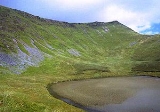
The mountain lies on main ridge of the Berwyns which runs north–south. The eastern side of the ridge is characterised by steep drops and crags including Craig Berwyn north of the summit and Craig y Llyn to the south. Craig y Llyn forms the headwall of a cwm
, and it is to this that the word cadair (chair in Welsh
) presumably refers. Further north along the ridge is Cadair Bronwen
, whilst to south the ridge continues to Moel Sych
(ˈmɔil ˈsɨːx, meaning 'dry hill').
It is often reported that Moel Sych
, 1 km along the ridge, is of equal height, but Cadair Berwyn's spot height on the Ordnance Survey
maps, where the trig point
stands, is not the true summit. Cadair Berwyn's summit, 200 m south of the trig point, is three metres taller than Moel Sych
. This summit is listed as Cadair Berwyn New Top on the Nuttall list.
Several other summits in the area are listed as Hewitts or Nuttalls, including Foel Wen
(ˈvɔil ˈwɛn, Welsh for white hill) and Mynydd Tarw
([ˈmɐnɨð ˈtæɾu], bull mountain).
The summit lies on the border between Powys
and Denbighshire
, and is the highest point in Denbighshire. The northern end Craig Berwyn is the highest point in Wrexham county borough.
There is a standing stone in the area, located near the summit between Cadair Berwyn and Tomle. This was re-erected in June 2008 by High Sports. The standing stone can be found at SJ080337.
Mountain
Image:Himalaya_annotated.jpg|thumb|right|The Himalayan mountain range with Mount Everestrect 58 14 160 49 Chomo Lonzorect 200 28 335 52 Makalurect 378 24 566 45 Mount Everestrect 188 581 920 656 Tibetan Plateaurect 250 406 340 427 Rong River...
summit in north east Wales
Wales
Wales is a country that is part of the United Kingdom and the island of Great Britain, bordered by England to its east and the Atlantic Ocean and Irish Sea to its west. It has a population of three million, and a total area of 20,779 km²...
. It is the highest point in the Berwyn range
Berwyn range
The Berwyn range is an isolated and sparsely populated area of moorland located in the north-east of Wales, roughly bounded by Llangollen in the north-east, Corwen in the north-west, Bala in the south-west, and Oswestry in the south-east.The Berwyn range also played its part in causing King Henry...
, and the highest significant summit in Wales outside the National Park
National park
A national park is a reserve of natural, semi-natural, or developed land that a sovereign state declares or owns. Although individual nations designate their own national parks differently A national park is a reserve of natural, semi-natural, or developed land that a sovereign state declares or...
s. Cadair Berwyn and Cyrniau Nod
Cyrniau Nod
Cyrniau Nod is a mountain summit in north east Wales. It is the smaller of the two Marilyns that form the Berwyn range, the other being Cadair Berwyn. Its summit has the Snowdonia National Park boundary running through it...
to the west are the two Marilyns that form the Berwyn range.
The mountain lies on main ridge of the Berwyns which runs north–south. The eastern side of the ridge is characterised by steep drops and crags including Craig Berwyn north of the summit and Craig y Llyn to the south. Craig y Llyn forms the headwall of a cwm
Cirque
Cirque may refer to:* Cirque, a geological formation* Makhtesh, an erosional landform found in the Negev desert of Israel and Sinai of Egypt*Cirque , an album by Biosphere* Cirque Corporation, a company that makes touchpads...
, and it is to this that the word cadair (chair in Welsh
Welsh language
Welsh is a member of the Brythonic branch of the Celtic languages spoken natively in Wales, by some along the Welsh border in England, and in Y Wladfa...
) presumably refers. Further north along the ridge is Cadair Bronwen
Cadair Bronwen
Cadair Bronwen is a mountain in North Wales and forms part of the Berwyn range. To the south are the higher Berwyn summits, including Cadair Berwyn. To the north lies Moel yr Henfaes and Moel Fferna, which top the north end of the Berwyn range. Cadair Bronwen used to be accompanied by a Nuttall...
, whilst to south the ridge continues to Moel Sych
Moel Sych
Moel Sych is a subsidiary summit of Cadair Berwyn in north east Wales. It is jointly the second highest summit in the Berwyn range along with Cadair Berwyn North Top....
(ˈmɔil ˈsɨːx, meaning 'dry hill').
It is often reported that Moel Sych
Moel Sych
Moel Sych is a subsidiary summit of Cadair Berwyn in north east Wales. It is jointly the second highest summit in the Berwyn range along with Cadair Berwyn North Top....
, 1 km along the ridge, is of equal height, but Cadair Berwyn's spot height on the Ordnance Survey
Ordnance Survey
Ordnance Survey , an executive agency and non-ministerial government department of the Government of the United Kingdom, is the national mapping agency for Great Britain, producing maps of Great Britain , and one of the world's largest producers of maps.The name reflects its creation together with...
maps, where the trig point
Trig point
A triangulation station, also known as a triangulation pillar, trigonometrical station, trigonometrical point, trig station, trig beacon or trig point, and sometimes informally as a trig, is a fixed surveying station, used in geodetic surveying and other surveying projects in its vicinity...
stands, is not the true summit. Cadair Berwyn's summit, 200 m south of the trig point, is three metres taller than Moel Sych
Moel Sych
Moel Sych is a subsidiary summit of Cadair Berwyn in north east Wales. It is jointly the second highest summit in the Berwyn range along with Cadair Berwyn North Top....
. This summit is listed as Cadair Berwyn New Top on the Nuttall list.
Several other summits in the area are listed as Hewitts or Nuttalls, including Foel Wen
Foel Wen
Foel Wen is a subsidiary summit of Cadair Berwyn in north east Wales. It is one of the summits found on the most easterly of Cadair Berwyn's long south ridges....
(ˈvɔil ˈwɛn, Welsh for white hill) and Mynydd Tarw
Mynydd Tarw
Mynydd Tarw is a subsidiary summit of Cadair Berwyn in north east Wales. It used to have a top: Rhos which has now been deleted as a Nuttall....
([ˈmɐnɨð ˈtæɾu], bull mountain).
The summit lies on the border between Powys
Powys
Powys is a local-government county and preserved county in Wales.-Geography:Powys covers the historic counties of Montgomeryshire and Radnorshire, most of Brecknockshire , and a small part of Denbighshire — an area of 5,179 km², making it the largest county in Wales by land area.It is...
and Denbighshire
Denbighshire
Denbighshire is a county in north-east Wales. It is named after the historic county of Denbighshire, but has substantially different borders. Denbighshire has the distinction of being the oldest inhabited part of Wales. Pontnewydd Palaeolithic site has remains of Neanderthals from 225,000 years...
, and is the highest point in Denbighshire. The northern end Craig Berwyn is the highest point in Wrexham county borough.
There is a standing stone in the area, located near the summit between Cadair Berwyn and Tomle. This was re-erected in June 2008 by High Sports. The standing stone can be found at SJ080337.
External links
- Computer generated summit panoramas Cadair Berwyn index
- www.geograph.co.uk : photos of Cadair Berwyn and surrounding area