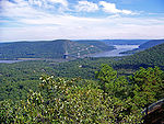
Buckberg
Encyclopedia

Hill
A hill is a landform that extends above the surrounding terrain. Hills often have a distinct summit, although in areas with scarp/dip topography a hill may refer to a particular section of flat terrain without a massive summit A hill is a landform that extends above the surrounding terrain. Hills...
above the Hudson River
Hudson River
The Hudson is a river that flows from north to south through eastern New York. The highest official source is at Lake Tear of the Clouds, on the slopes of Mount Marcy in the Adirondack Mountains. The river itself officially begins in Henderson Lake in Newcomb, New York...
that played a role in Revolutionary War strategy concerning the Hudson Highlands
Hudson Highlands
The Hudson Highlands are mountains on both sides of the Hudson River in the U.S. state of New York, between Newburgh Bay and Haverstraw Bay, which form the northern region of the New York - New Jersey Highlands....
. Its slopes rise directly from the riverbank to an elevation of about 793 feet (241.7 m) above Tomkins Cove
Tomkins Cove, New York
Tomkins Cove is an unincorporated hamlet in the Town of Stony Point Rockland County, New York, United States located north of Stony Point; east of Harriman State Park; south of Doodletown and west of the Hudson River. It is located north-northwest of New York City. The population is approximately...
, a section of Stony Point, New York
Stony Point, New York
Stony Point is a triangle-shaped town in Rockland County, United States. Rockland County is part of the New York Metropolitan Area. The town is located north of the town of Haverstraw, east and south of Orange County, New York, and west of the Hudson River and Westchester County. The population...
, in Rockland County. It is flanked on the north and south by Camp Addisone Boyce of the Girl Scouts of the USA
Girl Scouts of the USA
The Girl Scouts of the United States of America is a youth organization for girls in the United States and American girls living abroad. It describes itself as "the world's preeminent organization dedicated solely to girls". It was founded by Juliette Gordon Low in 1912 and was organized after Low...
and Camp Bullowa of the Boy Scouts of America
Boy Scouts of America
The Boy Scouts of America is one of the largest youth organizations in the United States, with over 4.5 million youth members in its age-related divisions...
. In recent years its forests have been largely subdivided and developed for upscale housing. http://query.nytimes.com/gst/fullpage.html?res=9C00E3D7143FF931A2575BC0A9679C8B63&sec=&spon=&pagewanted=all Buckberg lies about two miles (3 km) south and slightly west of Dunderberg Mountain
Dunderberg Mountain
Dunderberg Mountain stands at the so-called southern gate of the Hudson Highlands where the region's namesake Hudson River enters a dramatic gorge...
.
Buckberg is the site of Washington’s Lookout, an observation point used by General George Washington
George Washington
George Washington was the dominant military and political leader of the new United States of America from 1775 to 1799. He led the American victory over Great Britain in the American Revolutionary War as commander-in-chief of the Continental Army from 1775 to 1783, and presided over the writing of...
and Colonel “Mad” Anthony Wayne
Anthony Wayne
Anthony Wayne was a United States Army general and statesman. Wayne adopted a military career at the outset of the American Revolutionary War, where his military exploits and fiery personality quickly earned him a promotion to the rank of brigadier general and the sobriquet of Mad Anthony.-Early...
to plan a surprise attack on British troops in the Battle of Stony Point
Battle of Stony Point
The Battle of Stony Point was a battle of the American Revolutionary War fought on the night of July 15–16, 1779. A select force of Continental Army infantry made a coordinated surprise night attack and stormed a fortified position of the British Army on the Hudson River south of West Point, New...
. The post overlooked Haverstraw Bay
Haverstraw Bay
Haverstraw Bay, located in New York, is the widest portion of the Hudson River. The width of Haverstraw Bay is approximately 3.4 miles . The length approximately 5 miles from river kilometer 58 at Croton Point to river kilometer 66 at Stony Point...
and afforded views of the Hudson River to the north and south. http://www.osiny.org/site/PageServer?pagename=HRV_Washingtons_Lookout http://www.hudsonrivervalley.org/books/JULY2004.pdf
http://www.myrevolutionarywar.com/battles/790716.htm "Washington-Wayne Lookout Park" is a 5.2 acres (21,043.7 m²) historic site on the slopes of Buckberg purchased in February 2000 by a consortium led by the Open Space Institute
Open Space Institute
Open Space Institute is a conservation organization and think tank with an extensive mission statement. It seeks to preserve scenic, natural and historic landscapes for public enjoyment, conserve habitats while sustaining community character, and help protect the environment...
, with funds provided by
the "Lila Acheson and DeWitt Wallace
DeWitt Wallace
DeWitt Wallace , also known as William Roy was a United States magazine publisher. He co-founded Reader's Digest with his wife Lila Wallace and published the first issue in 1922.Born in St...
Fund for the Hudson Highlands
Hudson Highlands
The Hudson Highlands are mountains on both sides of the Hudson River in the U.S. state of New York, between Newburgh Bay and Haverstraw Bay, which form the northern region of the New York - New Jersey Highlands....
." http://www.hudsonriver.com/halfmoonpress/stories/0200open.htm http://www.osiny.org/site/PageServer?pagename=Feature_Revolutionary_War http://nysparks.state.ny.us/news/press/view.asp?pressID=261.
A few reliable sources are said to place Buckberg outside of the Hudson Highlands.

