Bruny Island, Tasmania
Encyclopedia
Bruny Island is an island off the south-eastern coast of Tasmania
, from which it is separated by the D’Entrecasteaux Channel. Storm Bay
is located to the island's northeast. Both the island and the channel are named after French explorer Bruni d'Entrecasteaux
. Its traditional Aboriginal name was Alonnah Lunawanna, which survives as the name of two island settlements, Alonnah
and Lunawanna.
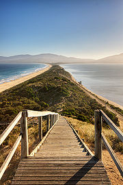
 Geologically, Bruny Island is actually two land masses - North Bruny and South Bruny - that are joined by a long, narrow sandy isthmus
. The holiday village of Dennes Point is located in North Bruny, while South Bruny is the site of the towns of Alonnah
, Adventure Bay
and Lunawanna.
Outside its settlements the island is covered in grazing fields and large tracts of dry eucalyptus
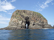
forest. Inland forests continue to be logged, but other large sections - mostly along the southeastern coast - are preserved as the South Bruny National Park. While the seaward side of the island features two long beaches - Adventure Bay and Cloudy Bay - it is for the most part extremely rugged, with cliffs of dolerite that tower over 200 metres above sea level, and which are amongst the highest sea cliffs in Australia. Bruny's channel side is far more sheltered and a favourite fishing and recreational boating area for local and interstate visitors.
Access to the island is by vehicular ferry, funded by the State Government. Since 1954, four vessels have operated the Bruny Island Ferry
service between the island and Kettering
on the mainland. The service is currently plied by the Mirambeena, which is unusual for using a Voith-Schneider
propulsion
system rather than a conventional propeller
.
The d'Entrecastaux Channel region, sheltered by Bruny Island, is increasingly subject to foreshore erosion, some areas have begun sandbagging to reduce the effects.
until European arrival, although there is still a large community of people who identify as Aboriginal. Abel Tasman
tried to land in the vicinity of Adventure Bay
in November 1642. In 1773 Tobias Furneaux
discovered and named Adventure Bay; four years later on 26 January 1777 James Cook
's two ships, the Resolution and Discovery stayed in the bay for two days. Cook carved his initials in a tree that was destroyed in a 1905 bushfire and is now commemorated by a plaque. In 1788 and again in 1792 William Bligh
anchored in Adventure Bay. The island itself however is named after the French explorer Bruni d'Entrecasteaux
who explored the Channel region in 1792. It was known as Bruni Island until 1918, when the spelling was changed to Bruny. Since then the island has become known as a holiday location with surfing beaches, National Parks and historical sites. In more recent history the Bruny Island was the site of a land transfer by the state Government to local Aboriginal people.
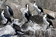
as an Important Bird Area
because it supports the world's largest population of the endangered Forty-spotted Pardalote
, up to a third of the world population of the Swift Parrot
, 13 of Tasmania's 14 endemic bird species, and up to 240,000 breeding pairs of the Short-tailed Shearwater
(or Tasmanian Muttonbird).
 A key contributor to Bruny Island's economy is its growing tourism industry. Being home to the South Bruny National Park
, tourism on the island centres around the showcase of its natural assets.
The Cape Bruny Lighthouse
(1838) is an iconic Australian lighthouse and was the oldest continuous lighthouse under operation by the Commonwealth. Now out of service, it has been transferred to the Tasmanian Government and is part of the South Bruny National Park.
In 2010/11, overall visitors to Bruny Island increased 4% to 74,600. The island is primarily a day-trip destination with only 21,800 visitors staying on the island overnight. There are a growing number of tourism businesses on the island including a cheese factory, oyster farm, vineyard, smokehouse, lighthouse, museum, art gallery, two eco-cruises along with various accommodation properties and cafes.
 The main areas of Bruny Island include:
Tasmania
Tasmania is an Australian island and state. It is south of the continent, separated by Bass Strait. The state includes the island of Tasmania—the 26th largest island in the world—and the surrounding islands. The state has a population of 507,626 , of whom almost half reside in the greater Hobart...
, from which it is separated by the D’Entrecasteaux Channel. Storm Bay
Storm Bay
Storm Bay is a large bay in the south-east of Tasmania, Australia. It is the entrance to the Derwent River estuary and the port of Hobart, the capital city of Tasmania.It is bordered by Bruny Island to the west and the Tasman Peninsula to the east....
is located to the island's northeast. Both the island and the channel are named after French explorer Bruni d'Entrecasteaux
Bruni d'Entrecasteaux
Antoine Raymond Joseph de Bruni d'Entrecasteaux was a French navigator who explored the Australian coast in 1792 while seeking traces of the lost expedition of La Pérouse....
. Its traditional Aboriginal name was Alonnah Lunawanna, which survives as the name of two island settlements, Alonnah
Alonnah, Tasmania
Alonnah is a small township on the western side of Bruny Island, Tasmania, facing the D'Entrecasteaux Channel. Originally named Mill's Reef, it was renamed in the early 1900s after part of the Tasmanian aboriginal name for Bruny Island, Lunawanna-alonnah Alonnah (Australian Postcode 7150) is a...
and Lunawanna.
Geography

Isthmus
An isthmus is a narrow strip of land connecting two larger land areas usually with waterforms on either side.Canals are often built through isthmuses where they may be particularly advantageous to create a shortcut for marine transportation...
. The holiday village of Dennes Point is located in North Bruny, while South Bruny is the site of the towns of Alonnah
Alonnah, Tasmania
Alonnah is a small township on the western side of Bruny Island, Tasmania, facing the D'Entrecasteaux Channel. Originally named Mill's Reef, it was renamed in the early 1900s after part of the Tasmanian aboriginal name for Bruny Island, Lunawanna-alonnah Alonnah (Australian Postcode 7150) is a...
, Adventure Bay
Adventure Bay, Tasmania
Adventure Bay is the name of both a township and a geographical feature on the eastern side of Bruny Island, Tasmania. At the 2006 census, Adventure Bay and the surrounding area had a population of 152....
and Lunawanna.
Outside its settlements the island is covered in grazing fields and large tracts of dry eucalyptus
Eucalyptus
Eucalyptus is a diverse genus of flowering trees in the myrtle family, Myrtaceae. Members of the genus dominate the tree flora of Australia...
forest. Inland forests continue to be logged, but other large sections - mostly along the southeastern coast - are preserved as the South Bruny National Park. While the seaward side of the island features two long beaches - Adventure Bay and Cloudy Bay - it is for the most part extremely rugged, with cliffs of dolerite that tower over 200 metres above sea level, and which are amongst the highest sea cliffs in Australia. Bruny's channel side is far more sheltered and a favourite fishing and recreational boating area for local and interstate visitors.
Access to the island is by vehicular ferry, funded by the State Government. Since 1954, four vessels have operated the Bruny Island Ferry
Bruny Island Ferry
The Bruny Island Ferry links Bruny Island to the Tasmanian mainland. Operated by North Western Shipping and Towage Co. Pty Ltd and owned by the Tasmanian Government, the ferry Mirambeena travels between Kettering on the Tasmanian mainland and Roberts Point on Bruny Island...
service between the island and Kettering
Kettering, Tasmania
Kettering is a coastal town on the D'Entrecasteaux Channel. Kettering and Woodbridge nestle into the coast on the D'Entrecasteaux Channel opposite Bruny Island - two tiny settlements gazing across the narrow channel at the island's low lying hills...
on the mainland. The service is currently plied by the Mirambeena, which is unusual for using a Voith-Schneider
Voith-Schneider
The Voith Schneider propeller , also known as a cycloidal drive is a specialized marine propulsion system . It is highly maneuverable, being able to change the direction of its thrust almost instantaneously...
propulsion
Marine propulsion
Marine propulsion is the mechanism or system used to generate thrust to move a ship or boat across water. While paddles and sails are still used on some smaller boats, most modern ships are propelled by mechanical systems consisting a motor or engine turning a propeller, or less frequently, in jet...
system rather than a conventional propeller
Propeller
A propeller is a type of fan that transmits power by converting rotational motion into thrust. A pressure difference is produced between the forward and rear surfaces of the airfoil-shaped blade, and a fluid is accelerated behind the blade. Propeller dynamics can be modeled by both Bernoulli's...
.
The d'Entrecastaux Channel region, sheltered by Bruny Island, is increasingly subject to foreshore erosion, some areas have begun sandbagging to reduce the effects.
History
Bruny Island was originally inhabited by the AboriginesTasmanian Aborigines
The Tasmanian Aborigines were the indigenous people of the island state of Tasmania, Australia. Before British colonisation in 1803, there were an estimated 3,000–15,000 Parlevar. A number of historians point to introduced disease as the major cause of the destruction of the full-blooded...
until European arrival, although there is still a large community of people who identify as Aboriginal. Abel Tasman
Abel Tasman
Abel Janszoon Tasman was a Dutch seafarer, explorer, and merchant, best known for his voyages of 1642 and 1644 in the service of the VOC . His was the first known European expedition to reach the islands of Van Diemen's Land and New Zealand and to sight the Fiji islands...
tried to land in the vicinity of Adventure Bay
Adventure Bay
Adventure Bay is a bay on Bruny Island in southeastern Tasmania. Discovered in 1773 by Tobias Furneaux, it was named after his ship, HMS Adventure. James Cook explored the region in 1777, as did William Bligh in 1788 and 1792....
in November 1642. In 1773 Tobias Furneaux
Tobias Furneaux
Captain Tobias Furneaux was an English navigator and Royal Navy officer, who accompanied James Cook on his second voyage of exploration. He was the first man to circumnavigate the world in both directions....
discovered and named Adventure Bay; four years later on 26 January 1777 James Cook
James Cook
Captain James Cook, FRS, RN was a British explorer, navigator and cartographer who ultimately rose to the rank of captain in the Royal Navy...
's two ships, the Resolution and Discovery stayed in the bay for two days. Cook carved his initials in a tree that was destroyed in a 1905 bushfire and is now commemorated by a plaque. In 1788 and again in 1792 William Bligh
William Bligh
Vice Admiral William Bligh FRS RN was an officer of the British Royal Navy and a colonial administrator. A notorious mutiny occurred during his command of HMAV Bounty in 1789; Bligh and his loyal men made a remarkable voyage to Timor, after being set adrift in the Bounty's launch by the mutineers...
anchored in Adventure Bay. The island itself however is named after the French explorer Bruni d'Entrecasteaux
Bruni d'Entrecasteaux
Antoine Raymond Joseph de Bruni d'Entrecasteaux was a French navigator who explored the Australian coast in 1792 while seeking traces of the lost expedition of La Pérouse....
who explored the Channel region in 1792. It was known as Bruni Island until 1918, when the spelling was changed to Bruny. Since then the island has become known as a holiday location with surfing beaches, National Parks and historical sites. In more recent history the Bruny Island was the site of a land transfer by the state Government to local Aboriginal people.
Environment
Bruny Island is classified by BirdLife InternationalBirdLife International
BirdLife International is a global Partnership of conservation organisations that strives to conserve birds, their habitats and global biodiversity, working with people towards sustainability in the use of natural resources...
as an Important Bird Area
Important Bird Area
An Important Bird Area is an area recognized as being globally important habitat for the conservation of bird populations. Currently there are about 10,000 IBAs worldwide. The program was developed and sites are identified by BirdLife International...
because it supports the world's largest population of the endangered Forty-spotted Pardalote
Forty-spotted Pardalote
The Forty-spotted Pardalote is one of Australia's rarest birds and by far the rarest pardalote, being confined to the south-east corner of Tasmania.-Description:...
, up to a third of the world population of the Swift Parrot
Swift Parrot
The Swift Parrot breeds in Tasmania and migrates north to south eastern Australia from Griffith-Warialda in New South Wales and west to Adelaide in the winter. It is related to the rosellas, with the feeding habits of a lorikeet...
, 13 of Tasmania's 14 endemic bird species, and up to 240,000 breeding pairs of the Short-tailed Shearwater
Short-tailed Shearwater
The Short-tailed Shearwater or Slender-billed Shearwater , also called Yolla or Moonbird, and commonly known as the muttonbird in Australia, is the most abundant seabird species in Australian waters, and is one of the few Australian native birds in which the chicks are commercially harvested...
(or Tasmanian Muttonbird).
Tourism

South Bruny National Park
South Bruny National Park is located on Bruny Island, Tasmania, Australia, about 50 km south of Hobart. The park contains the Cape Bruny Lighthouse. The highest point of the park is Mount Bruny at 504 m...
, tourism on the island centres around the showcase of its natural assets.
The Cape Bruny Lighthouse
Cape Bruny Lighthouse
Cape Bruny Lighthouse at the southern tip of Bruny Island, Tasmania, is the second oldest extant lighthouse tower in Australia, as well as having the longest history of being continuously manned. Construction began in April 1836, it was first lit in March 1838, and was eventually decommissioned...
(1838) is an iconic Australian lighthouse and was the oldest continuous lighthouse under operation by the Commonwealth. Now out of service, it has been transferred to the Tasmanian Government and is part of the South Bruny National Park.
In 2010/11, overall visitors to Bruny Island increased 4% to 74,600. The island is primarily a day-trip destination with only 21,800 visitors staying on the island overnight. There are a growing number of tourism businesses on the island including a cheese factory, oyster farm, vineyard, smokehouse, lighthouse, museum, art gallery, two eco-cruises along with various accommodation properties and cafes.
Townships

- Adventure BayAdventure Bay, TasmaniaAdventure Bay is the name of both a township and a geographical feature on the eastern side of Bruny Island, Tasmania. At the 2006 census, Adventure Bay and the surrounding area had a population of 152....
- AlonnahAlonnah, TasmaniaAlonnah is a small township on the western side of Bruny Island, Tasmania, facing the D'Entrecasteaux Channel. Originally named Mill's Reef, it was renamed in the early 1900s after part of the Tasmanian aboriginal name for Bruny Island, Lunawanna-alonnah Alonnah (Australian Postcode 7150) is a...
- Barnes Bay
- Cloudy Bay
- Dennes Point
- Fluted Cape
- Lunawanna
- Simpsons Bay

