
Brodie Mountain
Encyclopedia
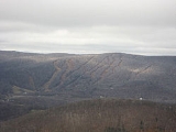
Brodie Mountain, 2621 feet (798.9 m), is a prominent 5.5 miles (8.9 km) long ridgeline in the Taconic Mountains
of western Massachusetts
, known for the former Brodie Mountain ski area
, which closed in 2002. The ridge has eight well defined summits, three of which have names: Sheep's Heaven Mountain, 2530 feet (771.1 m), the ridge's southern prominatory; Beoadic Mountain, the ridge high point, just north of Sheep's Heaven; and East Mountain, 2613 feet (796.4 m) located at the top of the former ski area at the center of the ridge. A northern summit, 2170 feet (661.4 m), is shown as "Brodie Mountain" on maps that predate the Brodie Mountain ski area.
formerly ran north over Sheep's Heaven Mountain to the Brodie Mountain ski area at the East Mountain summit, but has been discontinued on Brodie Mountain, although the former route, now an unsanctioned ATV trail, still exists. An older route once traversed the entire ridge from south to north, but the northern sections fell into disuse in the 1970s and are totally obscured. The former ski area, located on the east-center portion of the ridge, was purchased for 2.6 million dollars in 2004 by a developer; much of it is slated for condominium
development.
The Brodie Mountain ridge is located in the towns of Hancock
, Lanesborough
, New Ashford
, and Williamstown, Massachusetts
. It is bordered to the northeast by Mount Greylock
, to the south by Potter Mountain; and to the west by Misery Mountain
. The southwest side drains into Kinderhook Creek
, thence the Hudson River
and Long Island Sound
; the northwest side into the West Branch of the Green River, the Green River, the Hoosic River
, thence the Hudson River; the northeast side into East Brook, thence Green River; and the southeast side into Town Brook, the West Branch of the Housatonic River
, thence the Housatonic River and Long Island Sound. The mountain is forested in northern hardwood species
; its geology is Ordovician
phyllite
.
Taconic Mountains
The Taconic Mountains or Taconic Range are a physiographic section of the larger New England province and part of the Appalachian Mountains, running along the eastern border of New York State and adjacent New England from northwest Connecticut to western Massachusetts, north to central western...
of western Massachusetts
Massachusetts
The Commonwealth of Massachusetts is a state in the New England region of the northeastern United States of America. It is bordered by Rhode Island and Connecticut to the south, New York to the west, and Vermont and New Hampshire to the north; at its east lies the Atlantic Ocean. As of the 2010...
, known for the former Brodie Mountain ski area
Brodie Mountain (ski area)
Brodie was a ski resort in New Ashford, Massachusetts, in the Taconic Mountains in the far northwestern part of the state. It opened in 1964 and thrived for a time by using then-cutting-edge innovations like top-to-bottom snowmaking and lighted night skiing...
, which closed in 2002. The ridge has eight well defined summits, three of which have names: Sheep's Heaven Mountain, 2530 feet (771.1 m), the ridge's southern prominatory; Beoadic Mountain, the ridge high point, just north of Sheep's Heaven; and East Mountain, 2613 feet (796.4 m) located at the top of the former ski area at the center of the ridge. A northern summit, 2170 feet (661.4 m), is shown as "Brodie Mountain" on maps that predate the Brodie Mountain ski area.
Geography
The Taconic Skyline TrailTaconic Skyline Trail
The Taconic Skyline Trail is a multi-use trail in the Taconic Mountains of Berkshire County, Massachusetts. The trail extends from U.S. Route 20 in Hancock, Massachusetts, less than east of the New York border, north along the ridgecrest of the Taconic Range within Pittsfield State Forest and...
formerly ran north over Sheep's Heaven Mountain to the Brodie Mountain ski area at the East Mountain summit, but has been discontinued on Brodie Mountain, although the former route, now an unsanctioned ATV trail, still exists. An older route once traversed the entire ridge from south to north, but the northern sections fell into disuse in the 1970s and are totally obscured. The former ski area, located on the east-center portion of the ridge, was purchased for 2.6 million dollars in 2004 by a developer; much of it is slated for condominium
Condominium
A condominium, or condo, is the form of housing tenure and other real property where a specified part of a piece of real estate is individually owned while use of and access to common facilities in the piece such as hallways, heating system, elevators, exterior areas is executed under legal rights...
development.
The Brodie Mountain ridge is located in the towns of Hancock
Hancock, Massachusetts
Hancock is a town in Berkshire County, Massachusetts, United States. It is part of the Pittsfield, Massachusetts Metropolitan Statistical Area. The population was 717 at the 2010 census.- History :...
, Lanesborough
Lanesborough, Massachusetts
Lanesborough is a town in Berkshire County, Massachusetts, United States. It is part of the Pittsfield, Massachusetts Metropolitan Statistical Area. The population was 2,990 at the 2000 census.-History:...
, New Ashford
New Ashford, Massachusetts
New Ashford is a town in Berkshire County, Massachusetts, United States. It is part of the Pittsfield, Massachusetts Metropolitan Statistical Area. The population was 247 at the 2000 census.- History :...
, and Williamstown, Massachusetts
Williamstown, Massachusetts
Williamstown is a town in Berkshire County, in the northwest corner of Massachusetts. It shares a border with Vermont to the north and New York to the west. It is part of the Pittsfield, Massachusetts Metropolitan Statistical Area. The population was 7,754 at the 2010 census...
. It is bordered to the northeast by Mount Greylock
Mount Greylock
Mount Greylock is the highest natural point in Massachusetts at . Its peak is located in the northwest corner of the state in the western part of the town of Adams in Berkshire County. Although geologically part of the Taconic Mountains, Mount Greylock is commonly associated with the abutting...
, to the south by Potter Mountain; and to the west by Misery Mountain
Misery Mountain (Taconic Mountains)
Misery Mountain, , with at least ten well-defined summits, is a prominent long rideline in the Taconic Mountains of western Massachusetts and adjacent New York. The west side of the mountain is located in New York; the east side and high point lie within Massachusetts. The summit ridge is part...
. The southwest side drains into Kinderhook Creek
Kinderhook Creek
Kinderhook Creek is a tributary to Stockport Creek, an inlet of the Hudson River in the United States. From its source in Hancock, Massachusetts, the creek runs southwest through the Taconic Mountains into Rensselaer County, New York, and then into Columbia County...
, thence the Hudson River
Hudson River
The Hudson is a river that flows from north to south through eastern New York. The highest official source is at Lake Tear of the Clouds, on the slopes of Mount Marcy in the Adirondack Mountains. The river itself officially begins in Henderson Lake in Newcomb, New York...
and Long Island Sound
Long Island Sound
Long Island Sound is an estuary of the Atlantic Ocean, located in the United States between Connecticut to the north and Long Island, New York to the south. The mouth of the Connecticut River at Old Saybrook, Connecticut, empties into the sound. On its western end the sound is bounded by the Bronx...
; the northwest side into the West Branch of the Green River, the Green River, the Hoosic River
Hoosic River
The Hoosic River, also known as the Hoosac, the Hoosick and the Hoosuck , is a tributary of the Hudson River in the northeastern United States. The different spellings are the result of varying transliterations of the river's original Algonquian name...
, thence the Hudson River; the northeast side into East Brook, thence Green River; and the southeast side into Town Brook, the West Branch of the Housatonic River
Housatonic River
The Housatonic River is a river, approximately long, in western Massachusetts and western Connecticut in the United States. It flows south to southeast, and drains about of southwestern New England into Long Island Sound...
, thence the Housatonic River and Long Island Sound. The mountain is forested in northern hardwood species
Northern hardwood forest
The northern hardwood forest is a general type of North American forest ecosystem found over much of southeastern and south central Canada, extending south into the United States in northern New England and New York, and west along the Great Lakes to Minnesota and western Ontario...
; its geology is Ordovician
Ordovician
The Ordovician is a geologic period and system, the second of six of the Paleozoic Era, and covers the time between 488.3±1.7 to 443.7±1.5 million years ago . It follows the Cambrian Period and is followed by the Silurian Period...
phyllite
Phyllite
Phyllite is a type of foliated metamorphic rock primarily composed of quartz, sericite mica, and chlorite; the rock represents a gradation in the degree of metamorphism between slate and mica schist. Minute crystals of graphite, sericite, or chlorite impart a silky, sometimes golden sheen to the...
.