

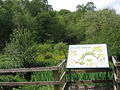
Breary Marsh
Encyclopedia
Nature reserve
A nature reserve is a protected area of importance for wildlife, flora, fauna or features of geological or other special interest, which is reserved and managed for conservation and to provide special opportunities for study or research...
and Site of Special Scientific Interest
Site of Special Scientific Interest
A Site of Special Scientific Interest is a conservation designation denoting a protected area in the United Kingdom. SSSIs are the basic building block of site-based nature conservation legislation and most other legal nature/geological conservation designations in Great Britain are based upon...
situated adjacent to Golden Acre Park
Golden Acre Park
Golden Acre Park is a public park between Adel and Bramhope, Leeds, West Yorkshire, England , administered by Leeds City Council. It is on the A660 Otley Road and covers an area of ....
in Leeds
Leeds
Leeds is a city and metropolitan borough in West Yorkshire, England. In 2001 Leeds' main urban subdivision had a population of 443,247, while the entire city has a population of 798,800 , making it the 30th-most populous city in the European Union.Leeds is the cultural, financial and commercial...
, .
As the name suggests, it includes an area of marshland, but also a wet alder
Alder
Alder is the common name of a genus of flowering plants belonging to the birch family . The genus comprises about 30 species of monoecious trees and shrubs, few reaching large size, distributed throughout the North Temperate Zone and in the Americas along the Andes southwards to...
valley wood. Wooden walkways are provided over marsh area. It is part of the Leeds Country Way
Leeds Country Way
The Leeds Country Way is a circular long-distance footpath of 62 miles around Leeds, West Yorkshire, England. It is never more than 7 miles from Leeds City Square, but is mainly rural with extensive views in the outlying areas of the Leeds metropolitan district...
and the north end of the Meanwood Valley Trail
Meanwood Valley Trail
The Meanwood Valley Trail is a waymarked footpath and annual footrace route in Leeds, West Yorkshire, England. It runs for a distance of from the statue of Henry Rowland Marsden, 1878, on Woodhouse Moor, close to the University of Leeds, through Headingley, Meanwood and Adel to Breary Marsh,...
.
The site is situated between Lawnswood
Lawnswood
Lawnswood is a small suburb in the north west of the city of Leeds in West Yorkshire, England. As such it is north north east of the West Yorkshire Urban Area.- Location :It is bordered by West Park, Adel, Ireland Wood and Holt Park...
and Bramhope
Bramhope
Bramhope is a village and civil parish in the City of Leeds metropolitan borough, West Yorkshire, England, north of Holt Park and north east of Cookridge....
off the A660
A660 road
The A660 is a major road in West Yorkshire, England that runs from Leeds to Burley-in-Wharfedale where it meets the A65. The A660 is approximately long, and crosses the watershed from Airedale to lower Wharfedale...
Otley Road. The adjacent park has a large car park and buses run close by from Leeds and Otley
Otley
-Transport:The main roads through the town are the A660 to the south east, which connects Otley to Bramhope, Adel and Leeds city centre, and the A65 to the west, which goes to Ilkley and Skipton. The A6038 heads to Guiseley, Shipley and Bradford, connecting with the A65...
.