

Brantingham
Encyclopedia
Brantingham is a village and civil parish in the East Riding of Yorkshire
, England
. It is situated about 2 miles (3.2 km) north of Brough
, and 12 miles (19.3 km) west of Kingston upon Hull
. It lies to the north of the A63 road
. According to the 2001 UK census
, Brantingham parish had a population of 410.
The noble family
of Brantingham
(or de Brantingham), which included Ralph de Brantingham
, King's Chamberlain
to King Edward III
and Thomas de Brantingham
, Lord Treasurer under the same king and later Bishop of Exeter
, originally came from the village.
It has one pub, a post office, and a duckpond.
The pub, called The Triton Inn, was formerly a coaching inn
on the road west from Hull - Brantingham then being an important staging post on the road between Welton
and South Cave
. At that time the present Triton Inn was called The Tiger inn and had a wheelwrights and an agricultural engineer (a Mr Watson) in the yard at the front. The pub changed its name to become the Wounded Tiger in the 1850s, but then in the 1860s was renamed The Triton, after part of the family crest of the Sykes family
, who bought nearby Brantingham Thorpe. They owned the pub as well as another Triton Inn on their Sledmere
estate just north of Driffield
(also in the East Riding of Yorkshire). The pub has been called The Triton Inn ever since.
 The site of Brantingham Roman villa is found at the other end of the long lane leading south east from the village, known as Brantingham Outgang. This villa would have been closely associated with the Roman town at Petuaria Civitas Parisiorum (Brough-on-Humber) until it burnt down some time in the mid-4th century. In what is nowadays a flat, gated area located next to a large wood overlooking the main road running between South Cave and Elloughton, traces of the villa (in the form of mosaic floors and hypocaust heated rooms) were first discovered in late September 1941 (in what had been a working quarry since the Middle Ages and into the 1980s). As a result of the quarrying there is now no trace today, but an aerial survey made during the war confirmed the presence of Roman buildings associated with the villa on the other side of the modern road. This Roman site attracted later notoriety in 1948, when a team of archaeologists from the Hull & East Riding museum prepared the first of a group of mosaic pavements found at the villa site during the war, for removal. Overnight it was stolen and although the rest were safely recovered to the museum and are on display to this day, the missing first one has never been found. Neither has it ever been established exactly how it was stolen. This notorious art theft
was later taken by the historical novelist Clive Ashman as the basis for his novel “MOSAIC – the Pavement that Walked” (Voreda Books) which provides a fictionalised account of both the 1941 discoveries, police investigations into the 1948 theft, and the original fate of the Roman villa. Today, only a full-colour reconstruction scale drawing taken by the mosaic expert David Neal from black-and-white photographs of the time survives to show what the stolen mosaic would have originally looked like.
In the 1950s the village gave its name to HMS Brantingham
, a Ham class minesweeper
.
Brantingham is on the major 155 bus route between Hull
and South Cave
/ Goole
/ Howden
, and is the last village west within the Hull telephone area.
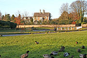
The village has several beautiful old houses of note - Brantingham Hall and Brantingham House, for example, which overlook the duck pond in the centre of the village.
Because Brantingham is situated on the western flank of the southern end of the Yorkshire Wolds
, its surrounding area has a somewhat different character depending whether you head east or west. Heading west is incredibly flat, as it heads across the Vale of York
. If you head west you enter the hills of the Yorkshire Wolds
. In this respect, Brantingham is possibly best known locally for Spout Hill, so named after the old water spout that is located at the bottom. The road from this spout leads steeply upwards, gaining 100 metres (328.1 ft) or so in height. This affords some good views westerly across the Vale of York
. The road then degrades to a bridleway leading to Riplingham
, Elloughton
and Welton
. Two-thirds of the way up Spout Hill is another path that leads south, through the woods to Elloughton
. The paths around and from Spout Hill are popular with walkers and runners. The climb of Spout Hill and its following bridleway is also popular with cyclists.
The Yorkshire Wolds Way
National Trail, a long distance footpath passes through the village.
East Riding of Yorkshire
The East Riding of Yorkshire, or simply East Yorkshire, is a local government district with unitary authority status, and a ceremonial county of England. For ceremonial purposes the county also includes the city of Kingston upon Hull, which is a separate unitary authority...
, England
England
England is a country that is part of the United Kingdom. It shares land borders with Scotland to the north and Wales to the west; the Irish Sea is to the north west, the Celtic Sea to the south west, with the North Sea to the east and the English Channel to the south separating it from continental...
. It is situated about 2 miles (3.2 km) north of Brough
Brough, East Riding of Yorkshire
Brough , or Brough-on-Humber, is a small town in the civil parish of Elloughton-cum-Brough in the East Riding of Yorkshire, England. The town has a population of around 7,000.-Location:...
, and 12 miles (19.3 km) west of Kingston upon Hull
Kingston upon Hull
Kingston upon Hull , usually referred to as Hull, is a city and unitary authority area in the ceremonial county of the East Riding of Yorkshire, England. It stands on the River Hull at its junction with the Humber estuary, 25 miles inland from the North Sea. Hull has a resident population of...
. It lies to the north of the A63 road
A63 road
The A63 is a major road in Yorkshire, England between Leeds and Hull.-Leeds – Howden:The route out to Selby is shadowed by the Leeds-Selby railway....
. According to the 2001 UK census
United Kingdom Census 2001
A nationwide census, known as Census 2001, was conducted in the United Kingdom on Sunday, 29 April 2001. This was the 20th UK Census and recorded a resident population of 58,789,194....
, Brantingham parish had a population of 410.
The noble family
Nobility
Nobility is a social class which possesses more acknowledged privileges or eminence than members of most other classes in a society, membership therein typically being hereditary. The privileges associated with nobility may constitute substantial advantages over or relative to non-nobles, or may be...
of Brantingham
Brantingham (family)
The Brantinghams are a once-noble family from North East England, originally from Brantingham in Yorkshire.-Coat of arms:...
(or de Brantingham), which included Ralph de Brantingham
Ralph de Brantingham
Ralph de Brantingham was an English noble of the mid-fourteenth century, who served as King's Chamberlain to Edward III.-Political offices:De Brantingham was appointed King's Chamberlain on 31 January 1349 and admitted the following day, 1 February 1349...
, King's Chamberlain
Lord Chamberlain
The Lord Chamberlain or Lord Chamberlain of the Household is one of the chief officers of the Royal Household in the United Kingdom and is to be distinguished from the Lord Great Chamberlain, one of the Great Officers of State....
to King Edward III
Edward III of England
Edward III was King of England from 1327 until his death and is noted for his military success. Restoring royal authority after the disastrous reign of his father, Edward II, Edward III went on to transform the Kingdom of England into one of the most formidable military powers in Europe...
and Thomas de Brantingham
Thomas de Brantingham
Thomas de Brantingham was an English clergyman who served as Lord Treasurer to Edward III and on two occasions to Richard II, and as bishop of Exeter from 1370 until his death...
, Lord Treasurer under the same king and later Bishop of Exeter
Bishop of Exeter
The Bishop of Exeter is the Ordinary of the Church of England Diocese of Exeter in the Province of Canterbury. The incumbent usually signs his name as Exon or incorporates this in his signature....
, originally came from the village.
It has one pub, a post office, and a duckpond.
The pub, called The Triton Inn, was formerly a coaching inn
Coaching inn
In Europe, from approximately the mid-17th century for a period of about 200 years, the coaching inn, sometimes called a coaching house or staging inn, was a vital part of the inland transport infrastructure, as an inn serving coach travelers...
on the road west from Hull - Brantingham then being an important staging post on the road between Welton
Welton, East Riding of Yorkshire
Welton is a village and civil parish in the East Riding of Yorkshire, England. It is situated approximately north of the town of Brough on the north side of the A63 road to Kingston upon Hull....
and South Cave
South Cave
South Cave is a town and civil parish in the East Riding of Yorkshire, England. It lies approximately to the west of Hull city centre on the A1034 road just to the north of the A63 road. North Cave is approximately to the north west.- Overview :...
. At that time the present Triton Inn was called The Tiger inn and had a wheelwrights and an agricultural engineer (a Mr Watson) in the yard at the front. The pub changed its name to become the Wounded Tiger in the 1850s, but then in the 1860s was renamed The Triton, after part of the family crest of the Sykes family
Sykes family of Sledmere
The Sykes family of Sledmere own Sledmere House in Yorkshire, England.-Family history:The Sykes family settled in Sykes Dyke near Carlisle in Cumberland during the Middle Ages. The earliest correspondence in the Sykes archives relates to Richard Sykes , from his factors in Danzig and local gentry...
, who bought nearby Brantingham Thorpe. They owned the pub as well as another Triton Inn on their Sledmere
Sledmere
Sledmere is a village in the East Riding of Yorkshire, England that is situated approximately north west of Driffield on the B1253 road.Together with the hamlet of Croome it forms the civil parish of Sledmere and Croome....
estate just north of Driffield
Driffield
Driffield, also known as Great Driffield, is a market town and civil parish in the East Riding of Yorkshire, England. The civil parish is formed by the town of Driffield and the village of Little Driffield....
(also in the East Riding of Yorkshire). The pub has been called The Triton Inn ever since.
Art theft
Art theft is usually for the purpose of resale or for ransom . Stolen art is sometimes used by criminals to secure loans.. One must realize that only a small percentage of stolen art is recovered. Estimates range from 5 to 10%. This means that little is known about the scope and characteristics of...
was later taken by the historical novelist Clive Ashman as the basis for his novel “MOSAIC – the Pavement that Walked” (Voreda Books) which provides a fictionalised account of both the 1941 discoveries, police investigations into the 1948 theft, and the original fate of the Roman villa. Today, only a full-colour reconstruction scale drawing taken by the mosaic expert David Neal from black-and-white photographs of the time survives to show what the stolen mosaic would have originally looked like.
In the 1950s the village gave its name to HMS Brantingham
HMS Brantingham
HMS Brantingham was one of 93 ships of the of inshore minesweepers.Their names were all chosen from villages ending in -ham. The minesweeper was named after Brantingham in the East Riding of Yorkshire.-References:...
, a Ham class minesweeper
Ham class minesweeper
The Ham class was a class of inshore minesweepers , known as the Type 1, of the British Royal Navy. The class was designed to operate in the shallow water of rivers and estuaries. It took its name from the fact that all the ship names were British place names ending in -"ham"...
.
Brantingham is on the major 155 bus route between Hull
Kingston upon Hull
Kingston upon Hull , usually referred to as Hull, is a city and unitary authority area in the ceremonial county of the East Riding of Yorkshire, England. It stands on the River Hull at its junction with the Humber estuary, 25 miles inland from the North Sea. Hull has a resident population of...
and South Cave
South Cave
South Cave is a town and civil parish in the East Riding of Yorkshire, England. It lies approximately to the west of Hull city centre on the A1034 road just to the north of the A63 road. North Cave is approximately to the north west.- Overview :...
/ Goole
Goole
Goole is a town, civil parish and port located approximately inland on the confluence of the rivers Don and Ouse in the East Riding of Yorkshire, England...
/ Howden
Howden
Howden is a small market town and civil parish in the East Riding of Yorkshire, England. It lies north of the M62, on the A614 road about north of Goole and south-west of York. William the Conqueror gave the town to the Bishops of Durham in 1080...
, and is the last village west within the Hull telephone area.
The village has several beautiful old houses of note - Brantingham Hall and Brantingham House, for example, which overlook the duck pond in the centre of the village.
Because Brantingham is situated on the western flank of the southern end of the Yorkshire Wolds
Yorkshire Wolds
The Yorkshire Wolds are low hills in the counties of East Riding of Yorkshire and North Yorkshire in northeastern England. The name also applies to the district in which the hills lie....
, its surrounding area has a somewhat different character depending whether you head east or west. Heading west is incredibly flat, as it heads across the Vale of York
Vale of York
The Vale of York is an area of flat land in the north-east of England. The vale is a major agricultural area and serves as the main north-south transport corridor for northern England....
. If you head west you enter the hills of the Yorkshire Wolds
Yorkshire Wolds
The Yorkshire Wolds are low hills in the counties of East Riding of Yorkshire and North Yorkshire in northeastern England. The name also applies to the district in which the hills lie....
. In this respect, Brantingham is possibly best known locally for Spout Hill, so named after the old water spout that is located at the bottom. The road from this spout leads steeply upwards, gaining 100 metres (328.1 ft) or so in height. This affords some good views westerly across the Vale of York
Vale of York
The Vale of York is an area of flat land in the north-east of England. The vale is a major agricultural area and serves as the main north-south transport corridor for northern England....
. The road then degrades to a bridleway leading to Riplingham
Riplingham
Riplingham is a little hamlet in the East Riding of Yorkshire, England.It is situated approximately south west of Beverley and east of South Cave.It is situated on the crossroads that link , South Cave, Welton, North Newbald and Raywell....
, Elloughton
Elloughton
Elloughton is a village in the East Riding of Yorkshire, England. It is situated approximately to the west of Kingston upon Hull to the south of the A63 road. It lies on the southern end of the Yorkshire Wolds. It is conjoined with Brough that lies to the south east, with which it forms the civil...
and Welton
Welton, East Riding of Yorkshire
Welton is a village and civil parish in the East Riding of Yorkshire, England. It is situated approximately north of the town of Brough on the north side of the A63 road to Kingston upon Hull....
. Two-thirds of the way up Spout Hill is another path that leads south, through the woods to Elloughton
Elloughton
Elloughton is a village in the East Riding of Yorkshire, England. It is situated approximately to the west of Kingston upon Hull to the south of the A63 road. It lies on the southern end of the Yorkshire Wolds. It is conjoined with Brough that lies to the south east, with which it forms the civil...
. The paths around and from Spout Hill are popular with walkers and runners. The climb of Spout Hill and its following bridleway is also popular with cyclists.
The Yorkshire Wolds Way
Yorkshire Wolds Way
The Yorkshire Wolds Way is a National Trail in Yorkshire, England. It runs 79 miles from Hessle to Filey, around the Yorkshire Wolds...
National Trail, a long distance footpath passes through the village.