

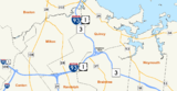
Braintree Split
Encyclopedia
The Braintree Split is the intersection of Interstate 93
/U.S. Route 1
and Massachusetts Route 3
located along the city line separating Braintree
and Quincy, Massachusetts
. The Braintree Split was also the southern end of Route 128 until 1997, when Route 128 was truncated to the I-95
/I-93
intersection in Canton
. Weekday traffic volume through the intersection averages 250,000 to 275,000 vehicles per day. The term "Braintree Split" is used as a focal point in all local radio and television traffic reports.
 The Braintree Split, technically a "Directional T" type of interchange, is the main road gateway to the South Shore
region of Massachusetts
, making it a critical point in Boston's highway system. The Southeast Expressway is the single limited access highway traveling south out of Boston, carrying traffic from the city destined for communities in populous Norfolk
(659,909 residents) and Plymouth
(492,066 residents) counties. Drivers other than those headed for parts of Milton
and Quincy which straddle the Expressway traverse the split to connect with Route 3 and Route 24 traveling to the more southern localities. Similarly, Boston traffic bound for cities and towns in Southeastern Massachusetts
including western Norfolk and Bristol County
(545,823 residents) and in Rhode Island
negotiate the Braintree Split prior to continuing along Route 24 or Interstate 95
. Finally, Route 3 serves as the primary freeway route to Cape Cod
from Boston's Inner Core. Travelers headed north from these destinations into Boston via I-93 likewise encounter the interchange in Braintree.
, a major regional shopping mall. It is adjacent to the I-93 intersection with Route 37
/Granite Street in Braintree which feeds retail, lodging, manufacturing and office complexes along Wood Road and Forbes Road, which run parallel to the north and south lanes of I-93 west of the split. The Crown Colony office complex in South Quincy
and office buildings on Willard Street, the northern continuation of Route 37/Granite Street into West Quincy
, are also accessed from the south via ramps at or next to the split. Short weaves, lane drops and line-of-sight problems all contribute to congestion in the interchange and the highways it serves. In addition to these issues, the split also serves the Quincy Adams
subway station and Burgin Parkway, a major route into downtown Quincy, through ramps exiting the directional ramps for each roadway.
Interstate 93
Interstate 93 is an Interstate Highway in the New England section of the United States. Its southern terminus is in Canton, Massachusetts, in the Boston metropolitan area, at Interstate 95; its northern terminus is near St. Johnsbury, Vermont, at Interstate 91...
/U.S. Route 1
U.S. Route 1 in Massachusetts
In the U.S. state of Massachusetts, U.S. Route 1 is a major north–south state highway through Boston. The portion of US 1 south of Boston is also known as the Boston-Providence Turnpike, and portions north of the city are known as the Northeast Expressway and the Newburyport Turnpike.-Route...
and Massachusetts Route 3
Route 3 (Massachusetts)
Route 3 is a southward continuation of U.S. Route 3, connecting Cambridge, Massachusetts with Cape Cod. All of it, except for the northernmost end in downtown Boston and Cambridge, is a freeway....
located along the city line separating Braintree
Braintree, Massachusetts
The Town of Braintree is a suburban city in Norfolk County, Massachusetts, United States. Although officially known as a town, Braintree adopted a municipal charter, effective 2008, with a mayor-council form of government and is considered a city under Massachusetts law. The population was 35,744...
and Quincy, Massachusetts
Quincy, Massachusetts
Quincy is a city in Norfolk County, Massachusetts, United States. Its nicknames are "City of Presidents", "City of Legends", and "Birthplace of the American Dream". As a major part of Metropolitan Boston, Quincy is a member of Boston's Inner Core Committee for the Metropolitan Area Planning Council...
. The Braintree Split was also the southern end of Route 128 until 1997, when Route 128 was truncated to the I-95
Interstate 95 in Massachusetts
Interstate 95 is the main highway on the East Coast of the United States, paralleling the Atlantic Ocean from Florida to Maine. The Massachusetts portion of the highway enters from the state of Rhode Island in Attleboro and travels in a northeasterly direction to the junction with Route 128 in...
/I-93
Interstate 93
Interstate 93 is an Interstate Highway in the New England section of the United States. Its southern terminus is in Canton, Massachusetts, in the Boston metropolitan area, at Interstate 95; its northern terminus is near St. Johnsbury, Vermont, at Interstate 91...
intersection in Canton
Canton, Massachusetts
Canton is a town in Norfolk County, Massachusetts, United States. The population was 21,561 at the 2010 census. Canton is part of Greater Boston, about 15 miles southwest of downtown Boston.- History :...
. Weekday traffic volume through the intersection averages 250,000 to 275,000 vehicles per day. The term "Braintree Split" is used as a focal point in all local radio and television traffic reports.
Boston's southern gateway
South Shore, Massachusetts
The South Shore of Massachusetts is a geographic region stretching south and east from Boston toward Cape Cod along the shores of Massachusetts Bay and Cape Cod Bay...
region of Massachusetts
Massachusetts
The Commonwealth of Massachusetts is a state in the New England region of the northeastern United States of America. It is bordered by Rhode Island and Connecticut to the south, New York to the west, and Vermont and New Hampshire to the north; at its east lies the Atlantic Ocean. As of the 2010...
, making it a critical point in Boston's highway system. The Southeast Expressway is the single limited access highway traveling south out of Boston, carrying traffic from the city destined for communities in populous Norfolk
Norfolk County, Massachusetts
-National protected areas:* Adams National Historical Park* Boston Harbor Islands National Recreation Area * Frederick Law Olmsted National Historic Site* John Fitzgerald Kennedy National Historic Site-Demographics:...
(659,909 residents) and Plymouth
Plymouth County, Massachusetts
Plymouth County is a county located in the U.S. state of Massachusetts. As of 2010, the population was 494,919. Its county seats are Plymouth and Brockton...
(492,066 residents) counties. Drivers other than those headed for parts of Milton
Milton, Massachusetts
Milton is a town in Norfolk County, Massachusetts, United States and part of the Greater Boston area. The population was 27,003 at the 2010 census. Milton is the birthplace of former U.S. President George H. W. Bush and architect Buckminster Fuller. Milton also has the highest percentage of...
and Quincy which straddle the Expressway traverse the split to connect with Route 3 and Route 24 traveling to the more southern localities. Similarly, Boston traffic bound for cities and towns in Southeastern Massachusetts
Southeastern Massachusetts
Southeastern Massachusetts is a term that refers to those portions of Massachusetts which are, by their proximity, economically and culturally linked to Providence, Rhode Island as well as Boston.-Definition:...
including western Norfolk and Bristol County
Bristol County, Massachusetts
-Demographics:As of the census of 2000, there were 534,678 people, 205,411 households, and 140,706 families residing in the county. The population density was 962 people per square mile . There were 216,918 housing units at an average density of 390 per square mile...
(545,823 residents) and in Rhode Island
Rhode Island
The state of Rhode Island and Providence Plantations, more commonly referred to as Rhode Island , is a state in the New England region of the United States. It is the smallest U.S. state by area...
negotiate the Braintree Split prior to continuing along Route 24 or Interstate 95
Interstate 95 in Massachusetts
Interstate 95 is the main highway on the East Coast of the United States, paralleling the Atlantic Ocean from Florida to Maine. The Massachusetts portion of the highway enters from the state of Rhode Island in Attleboro and travels in a northeasterly direction to the junction with Route 128 in...
. Finally, Route 3 serves as the primary freeway route to Cape Cod
Cape Cod
Cape Cod, often referred to locally as simply the Cape, is a cape in the easternmost portion of the state of Massachusetts, in the Northeastern United States...
from Boston's Inner Core. Travelers headed north from these destinations into Boston via I-93 likewise encounter the interchange in Braintree.
Congestion issues
Factors local to the Braintree Split contribute to chronic congestion at the interchange. The split is bordered on the south by South Shore PlazaSouth Shore Plaza
South Shore Plaza is an enclosed shopping mall located in Braintree, Massachusetts, United States. It is anchored by Lord & Taylor, Macy's, Sears, Nordstrom, and Target. The mall currently has of retail and dining space, including a large food court....
, a major regional shopping mall. It is adjacent to the I-93 intersection with Route 37
Massachusetts Route 37
- Route description:Route 37 begins in the north end of the city of Brockton at Route 28. After crossing the Middleboro-Lakeville Line and passing the Montello Station, it enters the town of Holbrook. It winds through the center of that town, where it intersects Route 139...
/Granite Street in Braintree which feeds retail, lodging, manufacturing and office complexes along Wood Road and Forbes Road, which run parallel to the north and south lanes of I-93 west of the split. The Crown Colony office complex in South Quincy
South Quincy (Quincy, Massachusetts)
South Quincy is a neighborhood of Quincy, Massachusetts. Located in the south central portion of the city, South Quincy is bordered on the north by Quincy Center and West Quincy, on the east by Quincy Avenue and the Quincy Point neighborhood, on the south by Braintree and on the west by Interstate...
and office buildings on Willard Street, the northern continuation of Route 37/Granite Street into West Quincy
West Quincy (Quincy, Massachusetts)
West Quincy is a neighborhood of Quincy, Massachusetts. It is bordered on the north by Wollaston, on the east by Quincy Center, on the south by South Quincy and on the west by the town of Milton and the Blue Hills Reservation.- History :...
, are also accessed from the south via ramps at or next to the split. Short weaves, lane drops and line-of-sight problems all contribute to congestion in the interchange and the highways it serves. In addition to these issues, the split also serves the Quincy Adams
Quincy Adams (MBTA station)
Quincy Adams Station, located at Burgin Parkway and Centre Street, in Quincy, Massachusetts, is the next to last station on the Massachusetts Bay Transportation Authority's Red Line Braintree branch....
subway station and Burgin Parkway, a major route into downtown Quincy, through ramps exiting the directional ramps for each roadway.