
Boy Scout Lane
Encyclopedia
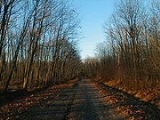
Boy Scout Lane, sometimes written “Boyscout Lane”, is an isolated road located in Stevens Point, Wisconsin
. A number of ghost stories and urban legends have become associated with the road, including the fictional deaths of a troop of Boy Scout
s. The area has been the subject of several paranormal investigations, and has been a 'haunt' for youths hoping to experience a paranormal event. The land surrounding Boy Scout Lane is now privately owned and is off limits to the general public.
, the road is named for a troop of Boy scouts who were killed while on a camping trip in the 1950s or 60s. In some variations the murderer is the troop's Scout master. In others it is their bus driver. In other versions of the legend, a small group of Scouts leave their camp during the night and accidentally drop their lantern, resulting in a forest fire that kills the entire troop.
Other variations of the story exist including one in which the scouts are killed after their bus crashes or accidentally catches fire. There is also a version in which the scouts vanish without explanation and are never found. In some versions of the legend, two boy scouts escaped the fate of the rest of the troop and tried to find help, only to become lost in the woods where they die of starvation and/or exposure. In most variations of the legend it is said that the dead scouts haunt the forest where they died and can be heard hiking through the undergrowth, or their lights can be seen at night as they seek help or their fellow scouts.
There is an associated legend in which the killer (usually the Scout leader) hangs himself from a tree in the area after coming to terms with what he has done. In this legend, the tree is said to be an elm tree overhanging the road.
Stories circulated in "haunted travel guides" include visitors reporting a strong sense of foreboding or 'being watched', the sound of footsteps or breaking branches coming from multiple directions, red or white lights sometimes described as resembling swinging lanterns or flashlight beams, ghostly buses or figures, and 'child-like hand prints' on cars stopped in or driven through the area.
township, Portage County
, Wisconsin
. It is located west of the Wisconsin River Golf Club, on West River Drive (West), and is situated between Cemetery Road and Little Chicago Road.
, who planned to use the land to build a Scout camp. Although the camp was never constructed and the land remains woodland, the name was still used.
Stevens Point, Wisconsin
Stevens Point is the county seat of Portage County, Wisconsin, United States. Located in the central part of the state, it is the largest city in the county, with a population of 24,551 at the 2000 census...
. A number of ghost stories and urban legends have become associated with the road, including the fictional deaths of a troop of Boy Scout
Boy Scout
A Scout is a boy or a girl, usually 11 to 18 years of age, participating in the worldwide Scouting movement. Because of the large age and development span, many Scouting associations have split this age group into a junior and a senior section...
s. The area has been the subject of several paranormal investigations, and has been a 'haunt' for youths hoping to experience a paranormal event. The land surrounding Boy Scout Lane is now privately owned and is off limits to the general public.
Urban legend
According to a local urban legendUrban legend
An urban legend, urban myth, urban tale, or contemporary legend, is a form of modern folklore consisting of stories that may or may not have been believed by their tellers to be true...
, the road is named for a troop of Boy scouts who were killed while on a camping trip in the 1950s or 60s. In some variations the murderer is the troop's Scout master. In others it is their bus driver. In other versions of the legend, a small group of Scouts leave their camp during the night and accidentally drop their lantern, resulting in a forest fire that kills the entire troop.
Other variations of the story exist including one in which the scouts are killed after their bus crashes or accidentally catches fire. There is also a version in which the scouts vanish without explanation and are never found. In some versions of the legend, two boy scouts escaped the fate of the rest of the troop and tried to find help, only to become lost in the woods where they die of starvation and/or exposure. In most variations of the legend it is said that the dead scouts haunt the forest where they died and can be heard hiking through the undergrowth, or their lights can be seen at night as they seek help or their fellow scouts.
There is an associated legend in which the killer (usually the Scout leader) hangs himself from a tree in the area after coming to terms with what he has done. In this legend, the tree is said to be an elm tree overhanging the road.
Stories circulated in "haunted travel guides" include visitors reporting a strong sense of foreboding or 'being watched', the sound of footsteps or breaking branches coming from multiple directions, red or white lights sometimes described as resembling swinging lanterns or flashlight beams, ghostly buses or figures, and 'child-like hand prints' on cars stopped in or driven through the area.
Location
Boy Scout Lane is in Stevens Point, LinwoodLinwood, Wisconsin
Linwood is a town in Portage County, Wisconsin, United States. The population was 1,111 at the 2000 census.-Geography:According to the United States Census Bureau, the town has a total area of 33.8 square miles , of which, 31.9 square miles of it is land and 1.8 square miles of it ...
township, Portage County
Portage County, Wisconsin
Portage County is a county in the U.S. state of Wisconsin. As of 2000, the population was 67,182. Its county seat is Stevens Point. The United States Census Bureau's Stevens Point Micropolitan Statistical Area includes all of Portage County.-Geography:...
, Wisconsin
Wisconsin
Wisconsin is a U.S. state located in the north-central United States and is part of the Midwest. It is bordered by Minnesota to the west, Iowa to the southwest, Illinois to the south, Lake Michigan to the east, Michigan to the northeast, and Lake Superior to the north. Wisconsin's capital is...
. It is located west of the Wisconsin River Golf Club, on West River Drive (West), and is situated between Cemetery Road and Little Chicago Road.
Name
Historically, the road was named “Boy Scout Lane” because the land that it is located on was once owned by the Boy Scouts of AmericaBoy Scouts of America
The Boy Scouts of America is one of the largest youth organizations in the United States, with over 4.5 million youth members in its age-related divisions...
, who planned to use the land to build a Scout camp. Although the camp was never constructed and the land remains woodland, the name was still used.