

Bower's Hill, Virginia
Encyclopedia
Independent city
An independent city is a city that does not form part of another general-purpose local government entity. These type of cities should not be confused with city-states , which are fully sovereign cities that are not part of any other sovereign state.-Historical precursors:In the Holy Roman Empire,...
of Chesapeake, Virginia
Chesapeake, Virginia
As of the census of 2000, there were 199,184 people, 69,900 households, and 54,172 families residing in the city. The population density was 584.6 people per square mile . There were 72,672 housing units at an average density of 213.3 per square mile...
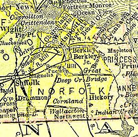
(formerly Norfolk County
Norfolk County, Virginia
Norfolk County was a county of the South Hampton Roads in eastern Virginia in the United States that was created in 1691. After the American Civil War, for a period of about 100 years, portions of Norfolk County were lost and the territory of the county reduced as they became parts of the separate...
) in the United States
United States
The United States of America is a federal constitutional republic comprising fifty states and a federal district...
. It is located in the South Hampton Roads
South Hampton Roads
South Hampton Roads is a region located in the extreme southeastern portion of Virginia in the United States, and is part of the Virginia Beach-Norfolk-Newport News, VA-NC MSA with a population about 1.7 million....
region at the northeastern edge of the Great Dismal Swamp
Great Dismal Swamp
The Great Dismal Swamp is a marshy area on the Coastal Plain Region of southeastern Virginia and northeastern North Carolina between Norfolk, Virginia, and Elizabeth City, North Carolina in the United States. It is located in parts of southern Chesapeake and Suffolk in Virginia, as well as northern...
, an area consisting of generally low-lying sandy terrain of the coastal plain
Coastal plain
A coastal plain is an area of flat, low-lying land adjacent to a seacoast and separated from the interior by other features. One of the world's longest coastal plains is located in eastern South America. The southwestern coastal plain of North America is notable for its species diversity...
.
Popular legend has that it was named for an early highway overpass on the Military Highway
Military Highway
Military Highway is a four-lane roadway built in the South Hampton Roads region of eastern Virginia, USA during World War II.- Original construction :...
which was built around 1943. However, maps dating from the early 19th century show a place named "Bower's Hill". Other information in archives at the Library of Virginia also dates the name to a time long prior to the construction of the Military Highway.
In any event, the area now justifies its name with an elaborate interchange of overpasses at the juncture of three Interstate highways and three arterial (U.S.) highways. Bower's Hill is also the possible location of a future high speed rail passenger station.
History
Bower's Hill, which was in now-extinct Norfolk CountyNorfolk County, Virginia
Norfolk County was a county of the South Hampton Roads in eastern Virginia in the United States that was created in 1691. After the American Civil War, for a period of about 100 years, portions of Norfolk County were lost and the territory of the county reduced as they became parts of the separate...
near the northeastern edge of the Great Dismal Swamp
Great Dismal Swamp
The Great Dismal Swamp is a marshy area on the Coastal Plain Region of southeastern Virginia and northeastern North Carolina between Norfolk, Virginia, and Elizabeth City, North Carolina in the United States. It is located in parts of southern Chesapeake and Suffolk in Virginia, as well as northern...
, became a crossroads as highways and railroads were built through the area in the 20th century. The natural terrain of the coastal plain
Coastal plain
A coastal plain is an area of flat, low-lying land adjacent to a seacoast and separated from the interior by other features. One of the world's longest coastal plains is located in eastern South America. The southwestern coastal plain of North America is notable for its species diversity...
of the Tidewater
Tidewater region of Virginia
The Tidewater region of Virginia is the eastern portion of the Commonwealth of Virginia formally known as Hampton Roads. The term tidewater may be correctly applied to all portions of any area, including Virginia, where the water level is affected by the tides...
area is very flat and sandy. The combination of U.S. Highway 13, U.S. Highway 58, and U.S. Highway 460, known as the Military Highway
Military Highway
Military Highway is a four-lane roadway built in the South Hampton Roads region of eastern Virginia, USA during World War II.- Original construction :...
, was a 4-lane undivided highway that was built about 1943. A large s-shaped highway overpass was constructed to carry the traffic across the Seaboard Air Line Railroad
Seaboard Air Line Railroad
The Seaboard Air Line Railroad , which styled itself "The Route of Courteous Service," was an American railroad whose corporate existence extended from April 14, 1900, until July 1, 1967, when it merged with the Atlantic Coast Line Railroad, its longtime rival, to form the Seaboard Coast Line...
tracks to eliminate an at-grade crossing and to allow an interchange with Airline Boulevard.
The highway there originally was 4-lane undivided with a 45-mph S-curve as the highway passed on a bridge over the railroad, and with short approach fills with considerable grades to the bridge. Although the name Bower's Hill was attached to the area as early as the 19th century, as one of the highest features for miles around, the newly-created overpass at Bower's Hill became something of a landmark for travelers in the 1950s and 1960s before creation of the U.S. Interstate Highway System beginning in 1956. Many people concluded (incorrectly) that the new overpasses were the source of the name.
In 1963, the voters of Norfolk County and the independent city of South Norfolk
South Norfolk, Virginia
South Norfolk was an independent city in the South Hampton Roads region of eastern Virginia and is now a section of the City of Chesapeake, one of the cities of Hampton Roads which surround the harbor of Hampton Roads and are linked by the Hampton Roads Beltway.-History:Located a few miles south of...
chose to consolidate into a new city, and Chesapeake
Chesapeake, Virginia
As of the census of 2000, there were 199,184 people, 69,900 households, and 54,172 families residing in the city. The population density was 584.6 people per square mile . There were 72,672 housing units at an average density of 213.3 per square mile...
was formed. Still-rural Bower's Hill became a borough of the new city. It is bordered to the north by another borough, Western Branch
Western Branch, Virginia
Western Branch is a community located in the independent city of Chesapeake, Virginia in the United States. It is located in the South Hampton Roads region and consists of generally low-lying sandy terrain of the coastal plain. The area is adjacent to a river from which its name derived...
.
Interstate Highways: Expanding the crossroads
The first portions of Interstate 264Interstate 264 (Virginia)
Interstate 264 is an Interstate Highway in the U.S. state of Virginia. It runs from a junction with Interstate 64 and Interstate 664 near Bowers Hill in Chesapeake east into Portsmouth and through the Downtown Tunnel under the South Branch of the Elizabeth River into Norfolk...
were opened beginning in 1964 and in 1966 were completed from Bower's Hill to the western approach to the Downtown Tunnel
Downtown Tunnel
The Downtown Tunnel on Interstate 264 crosses the Southern Branch of the Elizabeth River in the South Hampton Roads area. It links the independent City of Portsmouth with the independent City of Norfolk...
in Portsmouth
Portsmouth, Virginia
Portsmouth is located in the Hampton Roads metropolitan area of the U.S. Commonwealth of Virginia. As of 2010, the city had a total population of 95,535.The Norfolk Naval Shipyard, often called the Norfolk Navy Yard, is a historic and active U.S...
.
Interstate 64
Interstate 64
Interstate 64 is an Interstate Highway in the Midwestern and Southeastern United States. Its western terminus is at I-70, U.S. 40, and U.S. 61 in Wentzville, Missouri. Its eastern terminus is at an interchange with I-264 and I-664 at Bowers Hill in Chesapeake, Virginia. As I-64 is concurrent with...
, the region's major east-west artery was built through the area beginning in the 1960s. The 22 miles of I-64 between US-460 at Wards Corner in Norfolk and Bower's Hill in Chesapeake was completed in 1969. To reach the eastern terminus of the 945-mile interstate highway at Bower's Hill, eastbound I-64 was actually built in a westerly direction for its final eight miles. By 1970, Bower's Hill had two Interstate Highways, and 3 arterial highways.
An additional crossing of Hampton Roads
Hampton Roads
Hampton Roads is the name for both a body of water and the Norfolk–Virginia Beach metropolitan area which surrounds it in southeastern Virginia, United States...
, to supplement the James River Bridge
James River Bridge
The James River Bridge is a four-lane divided highway lift bridge across the James River in the U.S. state of Virginia. Owned and operated by the Virginia Department of Transportation, it carries U.S. Route 17, U.S. Route 258, and State Route 32 across the river near its mouth at Hampton Roads...
and the Hampton Roads Bridge-Tunnel
Hampton Roads Bridge-Tunnel
The Hampton Roads Bridge-Tunnel is the -long Hampton Roads crossing for Interstate 64 and U.S. Route 60. It is a four-lane facility comprising bridges, trestles, man-made islands, and tunnels under the main shipping channels for Hampton Roads harbor in the southeastern portion of Virginia in the...
was a long-sought highway improvement in the area. A north-south roadway between Bower's Hill and the Churchland area was also needed. Planning for what became Interstate 664
Interstate 664
Interstate 664 is an Interstate Highway in the U.S. state of Virginia. The Interstate runs from I-64 and I-264 in Chesapeake north to I-64 in Hampton. I-664 forms the west side of the Hampton Roads Beltway, a circumferential highway serving the Hampton Roads metropolitan area...
began as early as 1964.
One of the more recent portions of the interstate highway system to be built in Virginia, I-664 was completed in April 1992. The 20.7 mile long highway connects Bower's Hill with Hampton
Hampton, Virginia
Hampton is an independent city that is not part of any county in Southeast Virginia. Its population is 137,436. As one of the seven major cities that compose the Hampton Roads metropolitan area, it is on the southeastern end of the Virginia Peninsula. Located on the Hampton Roads Beltway, it hosts...
. I-664 includes the 4.6-mile-long Monitor-Merrimac Memorial Bridge-Tunnel
Monitor-Merrimac Memorial Bridge-Tunnel
Monitor-Merrimac Memorial Bridge-Tunnel is the 4.6 mile-long Hampton Roads crossing for Interstate 664 in the southeastern portion of Virginia in the United States...
across Hampton Roads between the independent cities of Newport News
Newport News, Virginia
Newport News is an independent city located in the Hampton Roads metropolitan area of Virginia. It is at the southeastern end of the Virginia Peninsula, on the north shore of the James River extending southeast from Skiffe's Creek along many miles of waterfront to the river's mouth at Newport News...
and Suffolk
Suffolk, Virginia
Suffolk is the largest city by area in Virginia, United States, and is located in the Hampton Roads metropolitan area. As of the 2010 census, the city had a total population of 84,585. Its median household income was $57,546.-History:...
.
Major overpasses were built in conjunction with I-664, and its junction with the other highways required the demolition of the original overpass and interchange. A similar bridge to the original overpass remains nearby on Military Highway, crossing the now-abandoned Virginian Railway
Virginian Railway
The Virginian Railway was a Class I railroad located in Virginia and West Virginia in the United States. The VGN was created to transport high quality "smokeless" bituminous coal from southern West Virginia to port at Hampton Roads....
bed.
Hampton Roads Beltway
In January, 1997, the 56-mile-long I-64/I-664 loop was designated by the Virginia Department of Transportation (and signed) as the Hampton Roads BeltwayHampton Roads Beltway
The Hampton Roads Beltway is a loop of Interstate 64 and Interstate 664, which links the communities of the Virginia Peninsula and South Hampton Roads which surround the body of water known as Hampton Roads and comprise much of the region of the same name in the southeastern portion of Virginia in...
. The beltway has the clockwise direction (as looking down at a map of the area) signed as the Inner Loop, and the counter-clockwise direction signed as the Outer Loop.
South Hampton Roads High Speed Rail
The Virginia General AssemblyVirginia General Assembly
The Virginia General Assembly is the legislative body of the Commonwealth of Virginia, and the oldest legislative body in the Western Hemisphere, established on July 30, 1619. The General Assembly is a bicameral body consisting of a lower house, the Virginia House of Delegates, with 100 members,...
commissioned several studies of the possibility of establishing high speed passenger rail service between Richmond
Richmond, Virginia
Richmond is the capital of the Commonwealth of Virginia, in the United States. It is an independent city and not part of any county. Richmond is the center of the Richmond Metropolitan Statistical Area and the Greater Richmond area...
and South Hampton Roads
South Hampton Roads
South Hampton Roads is a region located in the extreme southeastern portion of Virginia in the United States, and is part of the Virginia Beach-Norfolk-Newport News, VA-NC MSA with a population about 1.7 million....
. The under-utilized former Virginian Railway
Virginian Railway
The Virginian Railway was a Class I railroad located in Virginia and West Virginia in the United States. The VGN was created to transport high quality "smokeless" bituminous coal from southern West Virginia to port at Hampton Roads....
main line through the area (now owned by Norfolk Southern, was identified as a feasible corridor.
The Bower's Hill area was named as the preferred location for the site of a suburban passenger rail station, with the only other station to be in downtown Norfolk. While those plans are only in a study-phase, in the 21st century, Bower's Hill may become even more of a transportation hub.