

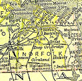
Norfolk County, Virginia
Encyclopedia
South Hampton Roads
South Hampton Roads is a region located in the extreme southeastern portion of Virginia in the United States, and is part of the Virginia Beach-Norfolk-Newport News, VA-NC MSA with a population about 1.7 million....
in eastern Virginia
Virginia
The Commonwealth of Virginia , is a U.S. state on the Atlantic Coast of the Southern United States. Virginia is nicknamed the "Old Dominion" and sometimes the "Mother of Presidents" after the eight U.S. presidents born there...
in the United States
United States
The United States of America is a federal constitutional republic comprising fifty states and a federal district...
that was created in 1691. After the American Civil War
American Civil War
The American Civil War was a civil war fought in the United States of America. In response to the election of Abraham Lincoln as President of the United States, 11 southern slave states declared their secession from the United States and formed the Confederate States of America ; the other 25...
, for a period of about 100 years, portions of Norfolk County were lost and the territory of the county reduced as they became parts of the separate and growing cities of Norfolk
Norfolk, Virginia
Norfolk is an independent city in the Commonwealth of Virginia in the United States. With a population of 242,803 as of the 2010 Census, it is Virginia's second-largest city behind neighboring Virginia Beach....
, Portsmouth
Portsmouth, Virginia
Portsmouth is located in the Hampton Roads metropolitan area of the U.S. Commonwealth of Virginia. As of 2010, the city had a total population of 95,535.The Norfolk Naval Shipyard, often called the Norfolk Navy Yard, is a historic and active U.S...
and South Norfolk
South Norfolk, Virginia
South Norfolk was an independent city in the South Hampton Roads region of eastern Virginia and is now a section of the City of Chesapeake, one of the cities of Hampton Roads which surround the harbor of Hampton Roads and are linked by the Hampton Roads Beltway.-History:Located a few miles south of...
.
In 1963, the remaining portions of Norfolk County were consolidated with the much smaller city of South Norfolk to form the new city of Chesapeake
Chesapeake, Virginia
As of the census of 2000, there were 199,184 people, 69,900 households, and 54,172 families residing in the city. The population density was 584.6 people per square mile . There were 72,672 housing units at an average density of 213.3 per square mile...
, a name selected by voters. Although organized as a city, and one of the larger in Virginia, Chesapeake has both busy suburban and industrial areas and mostly rural sections, including a large portion of the Great Dismal Swamp
Great Dismal Swamp
The Great Dismal Swamp is a marshy area on the Coastal Plain Region of southeastern Virginia and northeastern North Carolina between Norfolk, Virginia, and Elizabeth City, North Carolina in the United States. It is located in parts of southern Chesapeake and Suffolk in Virginia, as well as northern...
and large tracts of preserved forest land.
Shires to counties 1634-1691
During the 17th century, shortly after establishment of the Jamestown SettlementJamestown Settlement
Jamestown Settlement is a name used by the Commonwealth of Virginia's portion of the historical sites and museums at Jamestown. Jamestown was the first successful English settlement on the mainland of North America...
in 1607, English settlers explored and began settling the areas adjacent to Hampton Roads. By 1634, the English colony of Virginia consisted of eight shire
Shire
A shire is a traditional term for a division of land, found in the United Kingdom and in Australia. In parts of Australia, a shire is an administrative unit, but it is not synonymous with "county" there, which is a land registration unit. Individually, or as a suffix in Scotland and in the far...
s or counties
County
A county is a jurisdiction of local government in certain modern nations. Historically in mainland Europe, the original French term, comté, and its equivalents in other languages denoted a jurisdiction under the sovereignty of a count A county is a jurisdiction of local government in certain...
with a total population of approximately 5,000 inhabitants. One of these was Elizabeth City Shire
Elizabeth City Shire
Elizabeth City Shire was one of eight shires created in colonial Virginia in 1634. The shire and the Elizabeth River were named for Elizabeth of Bohemia, daughter of King James I....
, which included an area on both sides of Hampton Roads. The northern portion became Elizabeth City County
Elizabeth City County, Virginia
Elizabeth City County was a county in southeastern Virginia from 1634 to 1952. Originally created in 1634 as Elizabeth River Shire, it was one of eight shires created in the Virginia Colony by order of the King of England. In 1636, it was subdivided, and the portion north of the harbor of Hampton...
in 1643, and is now incorporated into the city limits of Hampton
Hampton, Virginia
Hampton is an independent city that is not part of any county in Southeast Virginia. Its population is 137,436. As one of the seven major cities that compose the Hampton Roads metropolitan area, it is on the southeastern end of the Virginia Peninsula. Located on the Hampton Roads Beltway, it hosts...
.
In 1636 the southern portion of Elizabeth City Shire became New Norfolk County by order of King Charles I
Charles I of England
Charles I was King of England, King of Scotland, and King of Ireland from 27 March 1625 until his execution in 1649. Charles engaged in a struggle for power with the Parliament of England, attempting to obtain royal revenue whilst Parliament sought to curb his Royal prerogative which Charles...
of England. This area was divided again in 1637 into Upper and Lower Norfolk Counties.
1691 Norfolk County created: Adam Thoroughgood
Princess Anne County, Virginia
Princess Anne County is a former county which was created in the British Colony of Virginia and the Commonwealth of Virginia in the United States in 1691. The county was merged into the city of Virginia Beach...
.
Captain Adam Thoroughgood
Adam Thoroughgood
Adam Thoroughgood was a colonist and community leader in the Virginia Colony who helped settle the area of South Hampton Roads known in contemporary times as the independent city of Virginia Beach, Virginia....
(1604-1640) is credited with naming Norfolk County. Thoroughgood was a prominent resident of the colony. Like so many others at that time, he had been born in England and migrated to Virginia. He named the new county after his original "home" county across the Atlantic Ocean.
After 1691, Norfolk County remained more or less intact for over 200 years. Portsmouth
Portsmouth, Virginia
Portsmouth is located in the Hampton Roads metropolitan area of the U.S. Commonwealth of Virginia. As of 2010, the city had a total population of 95,535.The Norfolk Naval Shipyard, often called the Norfolk Navy Yard, is a historic and active U.S...
became the county seat
County seat
A county seat is an administrative center, or seat of government, for a county or civil parish. The term is primarily used in the United States....
and a major area of commerce, along with Norfolk
Norfolk, Virginia
Norfolk is an independent city in the Commonwealth of Virginia in the United States. With a population of 242,803 as of the 2010 Census, it is Virginia's second-largest city behind neighboring Virginia Beach....
. Smaller towns were formed at Berkley
Berkley, Virginia
Berkley was an incorporated town in Norfolk County, Virginia. Chartered by an Act of Assembly in 1890, the Town of Berkley was located directly across the eastern branch of the Elizabeth River from the City of Norfolk in the South Hampton Roads area....
and South Norfolk
South Norfolk, Virginia
South Norfolk was an independent city in the South Hampton Roads region of eastern Virginia and is now a section of the City of Chesapeake, one of the cities of Hampton Roads which surround the harbor of Hampton Roads and are linked by the Hampton Roads Beltway.-History:Located a few miles south of...
. Portsmouth however remained the county seat
County seat
A county seat is an administrative center, or seat of government, for a county or civil parish. The term is primarily used in the United States....
of Norfolk County. In 1871 and 1919 respectively, Norfolk and South Norfolk also became independent cities and as such, were no longer in Norfolk County. In the following years, the county lost additional territory. The incorporated town
Incorporated town
-Canada:Incorporated towns are a form of local government in Canada, which is a responsibility of provincial rather than federal government.-United States:...
of Berkley
Berkley, Virginia
Berkley was an incorporated town in Norfolk County, Virginia. Chartered by an Act of Assembly in 1890, the Town of Berkley was located directly across the eastern branch of the Elizabeth River from the City of Norfolk in the South Hampton Roads area....
as well as the areas of Sewell's Point
Sewell's Point
Sewells Point is a peninsula of land in the independent city of Norfolk, Virginia in the United States, located at the mouth of the salt-water port of Hampton Roads. Sewells Point is bordered by water on three sides, with Willoughby Bay to the north, Hampton Roads to the west, and the Lafayette...
, Willoughby Spit
Willoughby Spit
Willoughby Spit is a peninsula of land in the independent city of Norfolk, Virginia in the United States. It is bordered by water on three sides: the Chesapeake Bay to the north, Hampton Roads to the west, and Willoughby Bay to the south.- History :...
, and Ocean View were lost to the City of Norfolk in multiple annexations. By 1960, the entire area of Norfolk County on the east side of the Elizabeth River
Elizabeth River (Virginia)
The Elizabeth River is a tidal estuary forming an arm of Hampton Roads harbor at the southern end of Chesapeake Bay in southeast Virginia in the United States. It is located along the southern side of the mouth of the James River, between the cities of Portsmouth and Norfolk...
north of Virginia Beach Boulevard was gone. On other sides, West Norfolk (Churchland) was lost to Portsmouth, and even South Norfolk had annexed a portion of the county.
1963: Creating a new city, Chesapeake
In Virginia, cities are immune from annexation by each other. The most recent attempt by the City of Norfolk to annex another portion of Norfolk County threatened to completely surround the tiny City of South NorfolkSouth Norfolk, Virginia
South Norfolk was an independent city in the South Hampton Roads region of eastern Virginia and is now a section of the City of Chesapeake, one of the cities of Hampton Roads which surround the harbor of Hampton Roads and are linked by the Hampton Roads Beltway.-History:Located a few miles south of...
. That failed annexation would have threatened South Norfolk's viability as an independent entity. Since Norfolk County residents also feared future annexation suits, in this odd battle of municipalities, Norfolk County and South Norfolk became allies.
A strategy successfully used about 10 years earlier by Elizabeth City County
Elizabeth City County, Virginia
Elizabeth City County was a county in southeastern Virginia from 1634 to 1952. Originally created in 1634 as Elizabeth River Shire, it was one of eight shires created in the Virginia Colony by order of the King of England. In 1636, it was subdivided, and the portion north of the harbor of Hampton...
, the Town of Phoebus
Phoebus, Virginia
Phoebus was an incorporated town located in Elizabeth City County on the Virginia Peninsula in eastern Virginia. Upon incorporation in 1900, it was named in honor of local businessman Harrison Phoebus , who is credited with convincing the Chesapeake and Ohio Railway to extend its tracks to the...
, and the City of Hampton
Hampton, Virginia
Hampton is an independent city that is not part of any county in Southeast Virginia. Its population is 137,436. As one of the seven major cities that compose the Hampton Roads metropolitan area, it is on the southeastern end of the Virginia Peninsula. Located on the Hampton Roads Beltway, it hosts...
offered a solution. In 1963, after a referendum of South Norfolk and Norfolk County's voters and the approval of the Virginia General Assembly
Virginia General Assembly
The Virginia General Assembly is the legislative body of the Commonwealth of Virginia, and the oldest legislative body in the Western Hemisphere, established on July 30, 1619. The General Assembly is a bicameral body consisting of a lower house, the Virginia House of Delegates, with 100 members,...
, South Norfolk and almost all of Norfolk County were joined by consolidation and reorganized as the new City of Chesapeake
Chesapeake, Virginia
As of the census of 2000, there were 199,184 people, 69,900 households, and 54,172 families residing in the city. The population density was 584.6 people per square mile . There were 72,672 housing units at an average density of 213.3 per square mile...
. The new name was chosen by the voters.
See also
- Elizabeth River Shire
- New Norfolk County
- Lower Norfolk County
- BerkleyBerkley, VirginiaBerkley was an incorporated town in Norfolk County, Virginia. Chartered by an Act of Assembly in 1890, the Town of Berkley was located directly across the eastern branch of the Elizabeth River from the City of Norfolk in the South Hampton Roads area....
- City of South NorfolkSouth Norfolk, VirginiaSouth Norfolk was an independent city in the South Hampton Roads region of eastern Virginia and is now a section of the City of Chesapeake, one of the cities of Hampton Roads which surround the harbor of Hampton Roads and are linked by the Hampton Roads Beltway.-History:Located a few miles south of...
- City of ChesapeakeChesapeake, VirginiaAs of the census of 2000, there were 199,184 people, 69,900 households, and 54,172 families residing in the city. The population density was 584.6 people per square mile . There were 72,672 housing units at an average density of 213.3 per square mile...
- City of NorfolkNorfolk, VirginiaNorfolk is an independent city in the Commonwealth of Virginia in the United States. With a population of 242,803 as of the 2010 Census, it is Virginia's second-largest city behind neighboring Virginia Beach....
- City of PortsmouthPortsmouth, VirginiaPortsmouth is located in the Hampton Roads metropolitan area of the U.S. Commonwealth of Virginia. As of 2010, the city had a total population of 95,535.The Norfolk Naval Shipyard, often called the Norfolk Navy Yard, is a historic and active U.S...
- Sewell's PointSewell's PointSewells Point is a peninsula of land in the independent city of Norfolk, Virginia in the United States, located at the mouth of the salt-water port of Hampton Roads. Sewells Point is bordered by water on three sides, with Willoughby Bay to the north, Hampton Roads to the west, and the Lafayette...
- Willoughby SpitWilloughby SpitWilloughby Spit is a peninsula of land in the independent city of Norfolk, Virginia in the United States. It is bordered by water on three sides: the Chesapeake Bay to the north, Hampton Roads to the west, and Willoughby Bay to the south.- History :...
- Ocean View
- Bower's Hill
- Lambert's PointLambert's PointLamberts Point is a point of land on the south shore of the Elizabeth River near the downtown area of the independent city of Norfolk in the South Hampton Roads region of eastern Virginia, United States...
- Deep CreekDeep Creek, VirginiaDeep Creek is a former unincorporated town of the former Norfolk County which since 1963 has been located in the independent city of Chesapeake in the South Hampton Roads region of southeastern Virginia. Deep Creek is located on the original route of U.S...
- Western BranchWestern Branch, VirginiaWestern Branch is a community located in the independent city of Chesapeake, Virginia in the United States. It is located in the South Hampton Roads region and consists of generally low-lying sandy terrain of the coastal plain. The area is adjacent to a river from which its name derived...
- Great BridgeGreat Bridge, VirginiaGreat Bridge is a community located in the independent city of Chesapeake in the U.S. state of Virginia. Its name is derived from the American Revolutionary War Battle of Great Bridge, which took place on December 9, 1775 and resulted in the final removal of British government from the Colony and...