
Bowditch's American Practical Navigator
Encyclopedia
 |
|
| Also known as: | "Bowditch", Publication Number Nine |
|---|---|
| Purpose: | Encyclopedia of navigation Navigation Navigation is the process of monitoring and controlling the movement of a craft or vehicle from one place to another. It is also the term of art used for the specialized knowledge used by navigators to perform navigation tasks... , valuable handbook on oceanography Oceanography Oceanography , also called oceanology or marine science, is the branch of Earth science that studies the ocean... and meteorology Meteorology Meteorology is the interdisciplinary scientific study of the atmosphere. Studies in the field stretch back millennia, though significant progress in meteorology did not occur until the 18th century. The 19th century saw breakthroughs occur after observing networks developed across several countries... , and contains useful tables and a maritime glossary. |
| Publication frequency: | Irregular |
| Published by: | Defense Mapping Agency Hydrographic Topographic Center (DMAHTC) |
| Available online: | Yes (Zip Zip Zip or ZIP most commonly refers to:*Zipper or zip, a device for temporarily joining two edges of fabric together*ZIP code, the USPS Zone Improvement Plan used in postal addresses in the USA*Zip drive, a removable data storage format... file) |
The American Practical Navigator (colloquially often referred to as Bowditch), originally written by Nathaniel Bowditch
Nathaniel Bowditch
Nathaniel Bowditch was an early American mathematician remembered for his work on ocean navigation. He is often credited as the founder of modern maritime navigation; his book The New American Practical Navigator, first published in 1802, is still carried on board every commissioned U.S...
, is an encyclopedia of navigation
Navigation
Navigation is the process of monitoring and controlling the movement of a craft or vehicle from one place to another. It is also the term of art used for the specialized knowledge used by navigators to perform navigation tasks...
. It serves as a valuable handbook on oceanography
Oceanography
Oceanography , also called oceanology or marine science, is the branch of Earth science that studies the ocean...
and meteorology
Meteorology
Meteorology is the interdisciplinary scientific study of the atmosphere. Studies in the field stretch back millennia, though significant progress in meteorology did not occur until the 18th century. The 19th century saw breakthroughs occur after observing networks developed across several countries...
, and contains useful tables and a maritime glossary. In 1867 the copyright
Copyright
Copyright is a legal concept, enacted by most governments, giving the creator of an original work exclusive rights to it, usually for a limited time...
and plates
Lithography
Lithography is a method for printing using a stone or a metal plate with a completely smooth surface...
were bought by the Hydrographic Office of the United States Navy
United States Navy
The United States Navy is the naval warfare service branch of the United States Armed Forces and one of the seven uniformed services of the United States. The U.S. Navy is the largest in the world; its battle fleet tonnage is greater than that of the next 13 largest navies combined. The U.S...
, and as a U.S. Government publication, it is now available free online. It is not only a notable book but is considered one of America's nautical institutions.
History
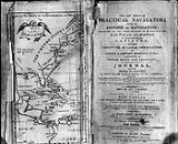
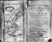
The most popular navigational text of the late 18th century was The New Practical Navigator by John Hamilton Moore. Edmund M. Blunt, a NewburyportNewburyport, Massachusetts
Newburyport is a small coastal city in Essex County, Massachusetts, United States, 35 miles northeast of Boston. The population was 21,189 at the 2000 census. A historic seaport with a vibrant tourism industry, Newburyport includes part of Plum Island...
, Massachusetts publisher, decided to issue a revised copy of this work for American navigators and convinced Nathaniel Bowditch
Nathaniel Bowditch
Nathaniel Bowditch was an early American mathematician remembered for his work on ocean navigation. He is often credited as the founder of modern maritime navigation; his book The New American Practical Navigator, first published in 1802, is still carried on board every commissioned U.S...
, a locally famous mariner and mathematician, to revise and update it with the help of several others. Blunt's The New Practical Navigator was published in 1799, followed by a second edition in 1800.
By 1802, when Blunt was ready to publish a third edition, Nathaniel Bowditch and others had corrected so many errors in Hamilton's work that Blunt decided to publish it as the first edition of a new work, The New American Practical Navigator. The current edition of the American Practical Navigator traces its pedigree to that 1802 edition. Edmund M. Blunt continued to publish the book until 1833; upon his retirement, his sons, Edmund and George, assumed publication. The elder Blunt died in 1862; his son Edmund followed in 1866. The next year, 1867, George Blunt sold the copyright to the government for $25,000. The government has published Bowditch ever since. George Blunt died in 1878.
Nathaniel Bowditch continued to correct and revise the book until his death in 1838. Upon his death, the editorial responsibility for The New American Practical Navigator passed to his son, J. Ingersoll Bowditch. Very few significant changes were made under him. Editions from 1837 through 1880 are nearly identical in content. Ingersoll Bowditch continued editing the Navigator until George Blunt sold the copyright to the government. He outlived all of the principals involved in publishing and editing the Navigator, dying in 1889.
The U.S. government has published some 52 editions since acquiring the copyright to the book that has come to be known simply by its original author’s name, "Bowditch". Since the government began production, the book has been known by its year of publishing, instead of by the edition number. After the first major revision, a total overhaul of the book's content completed in 1880 under the direction of Commander Philip H. Cooper, USN, the name was changed to American Practical Navigator. Much of Bowditch’s original content, including his methods for clearing lunar distance
Lunar distance (navigation)
In celestial navigation, lunar distance is the angle between the Moon and another celestial body. A navigator can use a lunar distance and a nautical almanac to calculate Greenwich time...
observations, were dropped in 1880 (though a new method for clearing lunars remained in an appendix until the early 20th century). After numerous incremental revisions and printings in the period from 1914 to 1944, Bowditch was extensively revised between 1946 and 1958.
The present volume, while retaining the basic format of the 1958 version, reorganizes the subjects, deletes obsolete text, and adds new material to keep pace with the extensive changes in navigation that have taken place in the electronic age.
This 1995 edition of the American Practical Navigator
incorporates extensive changes in organization, format, and
content. Recent advances in navigational electronics, communications,
positioning, and other technologies have transformed the way
navigation is practised at sea, and it is clear that even more
changes are forthcoming. The changes to this edition of Bowditch
are intended to ensure that this publication remains the premier
reference work for practical marine navigation. Concerted efforts
were made to return to Nathaniel Bowditch’s original intention
"to put down in the book nothing I can’t teach the crew." To this
end, many complex formulas and equations have been eliminated, and
emphasis placed on the capabilities and limitations of various
navigation systems and how to use them, instead of explaining
complex technical and theoretical details. This edition replaces
but does not cancel former editions, which may be retained and
consulted as to navigation methods not discussed herein.
The former Volume II has been incorporated into the primary volume
to save space and production cost. For similar reasons, the book
is now published on a larger page size. These two changes allow
the publisher to present a single, comprehensive navigation science
reference which explains modern navigational methods while respecting
traditional ones. The goal of the changes was to put as much useful
information before the navigator as possible in the most understandable and readable format.
Contents
Part I: Fundamentals, includes an overview of the types and phases of marine navigation and the organizations which support and regulate it. It includes chapters relating to the structure, use and limitations of nautical chartNautical chart
A nautical chart is a graphic representation of a maritime area and adjacent coastal regions. Depending on the scale of the chart, it may show depths of water and heights of land , natural features of the seabed, details of the coastline, navigational hazards, locations of natural and man-made aids...
s; chart datum
Chart datum
A chart datum is the level of water that charted depths displayed on a nautical chart are measured from. A chart datum is generally a tidal datum; that is, a datum derived from some phase of the tide...
s and their importance; and other material of a basic nature.
Part II: Piloting
Pilotage
Pilotage is the use of fixed visual references on the ground or sea by means of sight or radar to guide oneself to a destination, sometimes with the help of a map or nautical chart. People use pilotage for activities such as guiding vessels and aircraft, hiking and Scuba diving...
, emphasizes the practical aspects of navigating a vessel in restricted waters.
Part III: Electronic Navigation
Electronic navigation
Electronic navigation may refer to:*Global navigation satellite system, satellite navigation systems*Radio navigation, the application of radio frequencies to determining a position...
, covers the primary means of positioning of the modern navigator. Chapters deal with each of the several electronic methods of navigation, organized by type.
Part IV: Celestial Navigation
Celestial navigation
Celestial navigation, also known as astronavigation, is a position fixing technique that has evolved over several thousand years to help sailors cross oceans without having to rely on estimated calculations, or dead reckoning, to know their position...
, contains techniques, examples and problems and a chapter on sight reduction.
Part V: Navigational Mathematics, includes chapters relating to such topics as basic navigational mathematics and computer use in the solution of navigation problems.
Part VI: Navigational Safety, discusses aspects of the new distress and safety communications systems now in place or being implemented in the next several years, as well as navigation regulations, emergency navigation procedures, and distress communications.
Part VII: Oceanography
Oceanography
Oceanography , also called oceanology or marine science, is the branch of Earth science that studies the ocean...
, contains chapters on practical oceanography of use to the mariner.
Part VII: Marine Meteorology
Meteorology
Meteorology is the interdisciplinary scientific study of the atmosphere. Studies in the field stretch back millennia, though significant progress in meteorology did not occur until the 18th century. The 19th century saw breakthroughs occur after observing networks developed across several countries...
, incorporates weather routing and forecasting methods as well as color plates of the Beaufort
Beaufort scale
The Beaufort Scale is an empirical measure that relates wind speed to observed conditions at sea or on land. Its full name is the Beaufort Wind Force Scale.-History:...
Sea States.
Source
Portions of this article originated from the preface of The American Practical Navigator, a document produced by the government of the United States of America.See also
- BuoyBuoyA buoy is a floating device that can have many different purposes. It can be anchored or allowed to drift. The word, of Old French or Middle Dutch origin, is now most commonly in UK English, although some orthoepists have traditionally prescribed the pronunciation...
- Carry On, Mr. BowditchCarry On, Mr. BowditchCarry On, Mr. Bowditch is a novel by Jean Lee Latham that was awarded the Newbery Medal in 1956.The book is a children's biography of Nathaniel Bowditch, a sailor and mathematician who published the mammoth and comprehensive reference work for seamen: The American Practical Navigator...
- Coast PilotsCoast PilotsUnited States Coast Pilots is a nine-volume American navigation publication distributed yearly by the National Oceanic and Atmospheric Administration's Office of Coast Survey. The purpose of the publication is to supplement nautical charts of United States of America waters. Information comes...
- Day beaconDay beaconA day beacon is an unlighted nautical sea mark. Typically, day beacons mark channels whose key points are marked by lighted buoys. Day beacons may also mark smaller navigable routes in their entirety. They are the most common aid to nautical navigation in shallow water as they are relatively...
- DaymarkDaymarkA daymark or a day marker is a structure such as a tower constructed on land as an aid to navigation by sailors. While similar in concept to a lighthouse, a daymark does not have a light and so is usually only visible during daylight hours...
- Light ListLight ListThe United States Coast Guard Light List is an American navigation publication in 7 volumes made available yearly by the U.S. Coast Guard which gives information on lighted navigation aids, unlighted buoys, radiobeacons, radio direction finder calibration stations, daybeacons, racons, and LORAN...
- List of Lights
- Local Notice to MarinersLocal Notice to MarinersA Local Notice to Mariners is an authoritative instruction issued by a designated official, typically the harbormaster.-United States:In the United States, notices are issued by each U.S. Coast Guard District to disseminate important information affecting navigational safety within that District...
- Notice to MarinersNotice to MarinersA notice to mariners advises mariners of important matters affecting navigational safety, including new hydrographic information, changes in channels and aids to navigation, and other important data.Over 60 countries which produce nautical charts also...
- RACONRaconA racon is a radar transponder commonly used to mark maritime navigational hazards. The word is a portmanteau of RAdar and beaCON.When a racon receives a radar pulse, it responds with a signal on the same frequency which puts an image on the radar display...
- Sailing DirectionsSailing DirectionsSailing Directions is a 42-volume American navigation publication published by the National Geospatial-Intelligence Agency . Sailing Directions consists of 37 Enroute volumes, 4 Planning Guide volumes, and 1 volume combining both types...
External links
- Full text at Wikisource
- Full text (1995 ed.) in pdf files
- Full text (2002 Bicentennial Ed.); one PDF per chapter. Accessed 3 September 2011