
Botanie Mountain
Encyclopedia
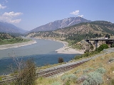
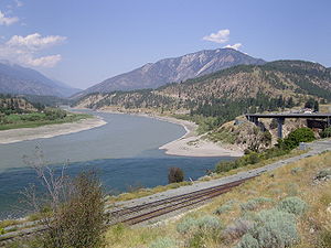
Botanie Mountain, also spelled Bootahnie Mountain, is a mountain
in the Clear Range
of the Southern Interior of British Columbia
, Canada
. It is located immediately north of the village of Lytton
, which is situated at the confluence of the Thompson
and Fraser River
s.
 A fire lookout
stands atop a peak approximately 3.5 kilometers to the south (elev. 1,992m) which is owned and maintained by the local wireless society for TV, radio, and digital transmission. The current view from the lookout can be seen via a live webcam. The lookout is accessible by two very rough 4x4 roads which approach from either end of the mountain, which is somewhat ridge-like, on a north-south axis. The roads have been decommissioned and are no longer driveable above a certain elevation. The summit is one of the highest on the east flank of the Fraser Canyon
and enjoys views over the Scarped Range and Thompson Plateau
to the east and southeast, across the Thompson River's lower canyon, the Clear Range
to the north and northwest, the Cascade Mountains to the south, and west across the Fraser to the Lillooet Ranges
.
or Nlaka'pamux
people, it means "covered", "covering" or "blanketed all over", which is thought to be a reference to its shroud of cloud or fog in times of bad weather, or else a reference to the abundant plant cover in the area. The Botanie Valley
, which is formed by Botanie Creek on its east flank and runs south from Botanie Lake, is an important food-plant gathering area for the Nlaka'pamux.
A publication of the Geological Survey of Canada, Summary Report from 1894, asserts the name-origin (p. 402B) to the Shuswap language
of the Secwepemc
people, meaning "perpetual root place". Secwepemc territory today begins in the basin of Hat Creek
, which lies on the "inside" of the Clear Range to the northwest of Botanie Mountain. The mountain is, however, decidedly in Nlaka'pamux territory.
Mountain
Image:Himalaya_annotated.jpg|thumb|right|The Himalayan mountain range with Mount Everestrect 58 14 160 49 Chomo Lonzorect 200 28 335 52 Makalurect 378 24 566 45 Mount Everestrect 188 581 920 656 Tibetan Plateaurect 250 406 340 427 Rong River...
in the Clear Range
Clear Range
The Clear Range is a small mountain range located in the angle of the Fraser and Thompson Rivers in south-central British Columbia. It has a small subdivision just northeast of that confluence named the Scarped Range...
of the Southern Interior of British Columbia
British Columbia Interior
The British Columbia Interior or BC Interior or Interior of British Columbia, usually referred to only as the Interior, is one of the three main regions of the Canadian province of British Columbia, the other two being the Lower Mainland, which comprises the overlapping areas of Greater Vancouver...
, Canada
Canada
Canada is a North American country consisting of ten provinces and three territories. Located in the northern part of the continent, it extends from the Atlantic Ocean in the east to the Pacific Ocean in the west, and northward into the Arctic Ocean...
. It is located immediately north of the village of Lytton
Lytton, British Columbia
Lytton in British Columbia, Canada, sits at the confluence of the Thompson River and Fraser River on the east side of the Fraser. The location has been inhabited by the Nlaka'pamux people for over 10,000 years, and is one of the earliest locations settled by non-natives in the Southern Interior of...
, which is situated at the confluence of the Thompson
Thompson River
The Thompson River is the largest tributary of the Fraser River, flowing through the south-central portion of British Columbia, Canada. The Thompson River has two main branches called the South Thompson and the North Thompson...
and Fraser River
Fraser River
The Fraser River is the longest river within British Columbia, Canada, rising at Fraser Pass near Mount Robson in the Rocky Mountains and flowing for , into the Strait of Georgia at the city of Vancouver. It is the tenth longest river in Canada...
s.
Access and fire lookout
Fire lookout
A fire lookout is a person assigned the duty to look for fire from atop a building known as a fire lookout tower. These towers are used in remote areas, normally on mountain tops with high elevation and a good view of the surrounding terrain, to spot smoke caused by a wildfire.Once a possible fire...
stands atop a peak approximately 3.5 kilometers to the south (elev. 1,992m) which is owned and maintained by the local wireless society for TV, radio, and digital transmission. The current view from the lookout can be seen via a live webcam. The lookout is accessible by two very rough 4x4 roads which approach from either end of the mountain, which is somewhat ridge-like, on a north-south axis. The roads have been decommissioned and are no longer driveable above a certain elevation. The summit is one of the highest on the east flank of the Fraser Canyon
Fraser Canyon
The Fraser Canyon is an 84 km landform of the Fraser River where it descends rapidly through narrow rock gorges in the Coast Mountains en route from the Interior Plateau of British Columbia to the Fraser Valley...
and enjoys views over the Scarped Range and Thompson Plateau
Thompson Plateau
The Thompson Plateau, also known as the Okanagan-Thompson Plateau, forms the southern portion of the Interior Plateau of British Columbia, Canada, lying to the west of Okanagan Lake, south of the Thompson River and to the east of the Fraser River...
to the east and southeast, across the Thompson River's lower canyon, the Clear Range
Clear Range
The Clear Range is a small mountain range located in the angle of the Fraser and Thompson Rivers in south-central British Columbia. It has a small subdivision just northeast of that confluence named the Scarped Range...
to the north and northwest, the Cascade Mountains to the south, and west across the Fraser to the Lillooet Ranges
Lillooet Ranges
The Lillooet Ranges are the southeasternmost subdivision of the Pacific Ranges of the Coast Mountains of British Columbia. They are located between the drainage of the Lillooet River and Harrison Lake on the west and the canyon of the Fraser River on the east, and by the lowland coastal valley of...
.
Name
The older spelling "Boothanie" is suggestive of the proper pronunciation of the mountain's name, i.e. it is unlike the English word "botany" and has been "phonetically" spelled as Boo-TAW-ny. In the language of the ThompsonThompson language
The Thompson language, properly known as Nlaka'pamuctsin or the Nlaka'pamux language, is an Interior Salishan language spoken in the Fraser Canyon, Thompson Canyon, Nicola Country of the Canadian province of British Columbia, and also in the North Cascades region of Whatcom and Chelan counties of...
or Nlaka'pamux
Nlaka'pamux
The Nlaka'pamux , commonly called "the Thompson", and also Thompson River Salish, Thompson Salish, Thompson River Indians or Thompson River people) are an indigenous First Nations/Native American people of the Interior Salish language group in southern British Columbia...
people, it means "covered", "covering" or "blanketed all over", which is thought to be a reference to its shroud of cloud or fog in times of bad weather, or else a reference to the abundant plant cover in the area. The Botanie Valley
Botanie Valley
Botanie Valley is in British Columbia's southern interior near Lytton. It is a traditional food source for the Nlaka'pamux people. The name itself means "covering" possibly referring to the abundant plant life covering the area...
, which is formed by Botanie Creek on its east flank and runs south from Botanie Lake, is an important food-plant gathering area for the Nlaka'pamux.
A publication of the Geological Survey of Canada, Summary Report from 1894, asserts the name-origin (p. 402B) to the Shuswap language
Shuswap language
The Shuswap language, known to its speakers as Secwepemctsín , is the traditional language of the Shuswap people of British Columbia. An endangered language, Shuswap is spoken mainly in the Central and Southern interior of British Columbia between the Fraser River and the Rocky Mountains...
of the Secwepemc
Secwepemc
The Secwepemc , known in English as the Shuswap people, are a First Nations people residing in the Canadian province of British Columbia. Their traditional territory ranges from the eastern Chilcotin Plateau and the Cariboo Plateau southeast through the Thompson Country to Kamloops and the Shuswap...
people, meaning "perpetual root place". Secwepemc territory today begins in the basin of Hat Creek
Hat Creek (British Columbia)
Hat Creek is a tributary of the Bonaparte River in British Columbia, Canada, joining that stream at Carquile, which is also known as Lower Hat Creek and is the site of the Hat Creek Ranch heritage museum and visitor centre...
, which lies on the "inside" of the Clear Range to the northwest of Botanie Mountain. The mountain is, however, decidedly in Nlaka'pamux territory.
External links
- Botanie Webcam on Lytton Community Wireless Internet webpage.
- Botanie Valley Advisory Committee a society dedicated to the social and ecological integrity of Botanie Valley.