
Boothferry
Encyclopedia
Boothferry is a village
in the East Riding of Yorkshire
in England
. It is situated on the north bank of the River Ouse
where the A614 road
crosses the river. It is about 2 miles (3.2 km) north-west of Goole
.
Boothferry is split between civil parishes, areas to the west of the B1228 road are in the civil parish of Asselby
and those to the east in Howden
.
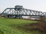
Boothferry is home to Boothferry Bridge which was the first physical crossing of the Ouse (if travelling inland). It was very heavily used by vehicles travelling between the north and south banks of the Humber
before the opening of the M62 motorway
in the mid-1970s and the Humber Bridge
in 1981. Boothferry Bridge is celebrated in the song "Boothferry Bridge" by the musical group "The Lonesome Travellers" which was released in the early 1970s. The M62 now crosses the Ouse on a viaduct approximately one mile downstream (east) of the old bridge.
Boothferry gave its name to the Boothferry borough of Humberside
from 1974 to 1996 and to the Boothferry parliamentary constituency
which, in 1997, was largely amalgamated into the Haltemprice and Howden constituency represented by David Davis MP
. Boothferry was also chosen to be the name taken by a local resident when he took the title of lord in 2004. Boothferry has also lent its name to many roads and buildings along with businesses within the borough although it is now defunct.
Hull City
Football Club played from 1946 to 2002 at a football stadium named Boothferry Park
, which also took its name from the village.
 In August, 2005, Graham Boanas, a Hull man, became the first person to successfully wade across the Humber since Roman times. The trek started on the north bank at Boothferry , 4 hours later, he made it across onto the south bank at Whitton
. The feat was attempted to raise cash and awareness for the medical research charity, DebRA.
Village
A village is a clustered human settlement or community, larger than a hamlet with the population ranging from a few hundred to a few thousand , Though often located in rural areas, the term urban village is also applied to certain urban neighbourhoods, such as the West Village in Manhattan, New...
in the East Riding of Yorkshire
East Riding of Yorkshire
The East Riding of Yorkshire, or simply East Yorkshire, is a local government district with unitary authority status, and a ceremonial county of England. For ceremonial purposes the county also includes the city of Kingston upon Hull, which is a separate unitary authority...
in England
England
England is a country that is part of the United Kingdom. It shares land borders with Scotland to the north and Wales to the west; the Irish Sea is to the north west, the Celtic Sea to the south west, with the North Sea to the east and the English Channel to the south separating it from continental...
. It is situated on the north bank of the River Ouse
River Ouse, Yorkshire
The River Ouse is a river in North Yorkshire, England. The river is formed from the River Ure at Cuddy Shaw Reach near Linton-on-Ouse, about 6 miles downstream of the confluence of the River Swale with the River Ure...
where the A614 road
A614 road
The A614 is a main road in England running through the counties of Nottinghamshire, South Yorkshire and the East Riding of Yorkshire.Beginning at Redhill, near Calverton in Nottinghamshire at a roundabout with the A60, the road meets the A6097 at a junction which looks like a roundabout but...
crosses the river. It is about 2 miles (3.2 km) north-west of Goole
Goole
Goole is a town, civil parish and port located approximately inland on the confluence of the rivers Don and Ouse in the East Riding of Yorkshire, England...
.
Boothferry is split between civil parishes, areas to the west of the B1228 road are in the civil parish of Asselby
Asselby
Asselby is a village and civil parish in the East Riding of Yorkshire, England. It is located in the south-west of the county, north of the River Ouse.It is situated approximately west of the market town of Howden....
and those to the east in Howden
Howden
Howden is a small market town and civil parish in the East Riding of Yorkshire, England. It lies north of the M62, on the A614 road about north of Goole and south-west of York. William the Conqueror gave the town to the Bishops of Durham in 1080...
.
Boothferry is home to Boothferry Bridge which was the first physical crossing of the Ouse (if travelling inland). It was very heavily used by vehicles travelling between the north and south banks of the Humber
Humber
The Humber is a large tidal estuary on the east coast of Northern England. It is formed at Trent Falls, Faxfleet, by the confluence of the tidal River Ouse and the tidal River Trent. From here to the North Sea, it forms part of the boundary between the East Riding of Yorkshire on the north bank...
before the opening of the M62 motorway
M62 motorway
The M62 motorway is a west–east trans-Pennine motorway in Northern England, connecting the cities of Liverpool and Hull via Manchester and Leeds. The road also forms part of the unsigned Euroroutes E20 and E22...
in the mid-1970s and the Humber Bridge
Humber Bridge
The Humber Bridge, near Kingston upon Hull, England, is a 2,220 m single-span suspension bridge, which opened to traffic on 24 June 1981. It is the fifth-largest of its type in the world...
in 1981. Boothferry Bridge is celebrated in the song "Boothferry Bridge" by the musical group "The Lonesome Travellers" which was released in the early 1970s. The M62 now crosses the Ouse on a viaduct approximately one mile downstream (east) of the old bridge.
Boothferry gave its name to the Boothferry borough of Humberside
Humberside
Humberside was a non-metropolitan and ceremonial county in Northern England from 1 April 1974 until 1 April 1996. It was composed of land from either side of the Humber Estuary, created from portions of the East and West ridings of Yorkshire and parts of Lindsey, Lincolnshire...
from 1974 to 1996 and to the Boothferry parliamentary constituency
Boothferry (UK Parliament constituency)
Boothferry was a constituency in Humberside which returned one Member of Parliament to the House of Commons of the Parliament of the United Kingdom. It was created for the 1983 general election, and abolished for the 1997 general election.-History:...
which, in 1997, was largely amalgamated into the Haltemprice and Howden constituency represented by David Davis MP
David Davis (British politician)
David Michael Davis is a British Conservative Party politician who is the Member of Parliament for the constituency of Haltemprice and Howden...
. Boothferry was also chosen to be the name taken by a local resident when he took the title of lord in 2004. Boothferry has also lent its name to many roads and buildings along with businesses within the borough although it is now defunct.
Hull City
Hull City A.F.C.
Hull City Association Football Club is an English association football club based in Kingston upon Hull, East Riding of Yorkshire, founded in 1904. The club participates in the Football League Championship, the second tier of English football...
Football Club played from 1946 to 2002 at a football stadium named Boothferry Park
Boothferry Park
Boothferry Park was a football stadium in Kingston upon Hull, and was home to the football club Hull City for over 50 years from 31 August 1946 until December 2002, when they moved to the Kingston Communications Stadium....
, which also took its name from the village.
Whitton, North Lincolnshire
Whitton is an English village and civil parish of about 170 inhabitants in North Lincolnshire. It is located at the northern termination of the Cliff range of hills, on the south shore of the Humber, about below Trent Falls, and west of Barton-upon-Humber...
. The feat was attempted to raise cash and awareness for the medical research charity, DebRA.