

Blue Earth County, Minnesota
Encyclopedia
Blue Earth County is a county located in the U.S. state
of Minnesota
. As of 2010, the population was 64,013. Its county seat
is Mankato
.
Blue Earth County is part of the Mankato–North Mankato
Metropolitan Statistical Area
.
flows through a part of the county. The land surface is relatively flat with over 30 lakes in the county. In the northeastern part of the county there are many forests that are called big woods. The rivers that flow out of the northeastern part are surrounded by these big woods. Most of the county is grassland prairie but scattered parts of it are wet prairie. Some spots that surround the rivers are oak openings and barren brushland.
" and was occupied by the Dakota Indians. It was started by a French explorer, Pierre-Charles Le Sueur
. He was one of the first White people
in this area, arriving at the point where the Minnesota and Blue Earth rivers meet. There, he made an unsuccessful attempt to mine copper from the blue earth found in the area. The area remained under French control until 1803, but soon after was passed to the United States by the Louisiana Purchase
. When Minnesota became a territory in 1849, the territorial government became interested in having the river valley for settlement. In 1850 the first steamboat trip, starting in St. Paul, traveled on the Minnesota River
and came to the Blue Earth River. The first White settlers, P.K. Johnson and Henry Jackson came off the boat and settled in present day Mankato. The ratification of the Mendota
and Traverse des Sioux
Treaties in 1851 effectively forced the Dakota to leave the area for nearby reservations
.
The county of Blue Earth was finally created after a division of the Minnesota Territory on March 5, 1853 from portions of Dakota County and free territory. It was named after the Blue Earth River
. The first government officials were appointed by Alexander Ramsey
, who was the territorial governor at that time. That October the first election was held for government officials with a total of 22 ballots being taken.
Unfulfilled treaty promises and starvation on the Indians reservation led to the Dakota War of 1862
, which resulted in Dakota defeat and the largest mass execution in US history in Mankato. In 1868 the railroads arrived. They helped with the growth and development of many areas, including Blue Earth. The railroads allowed many different White ethnic immigrants and Yankee settlers into the area. Blue Earth has grown into a very good county for agriculture, industry, business, education, and culture, and still continues to grow today.
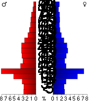 As of the census
of 2000, there were 55,941 people, 21,062 households, and 12,616 families residing in the county. The population density
was 74 people per square mile (29/km²). There were 21,971 housing units at an average density of 29 per square mile (11/km²). The racial makeup of the county was 94.96% White
, 1.19% Black
or African American
, 0.28% Native American
, 1.79% Asian
, 0.06% Pacific Islander
, 0.69% from other races
, and 1.03% from two or more races. 1.77% of the population were Hispanic
or Latino
of any race. 47.6% were of German, 13.6% Norwegian and 6.5% Irish
ancestry according to Census 2000.
There were 21,062 households out of which 29.10% had children under the age of 18 living with them, 48.60% were married couples
living together, 7.80% had a female householder with no husband present, and 40.10% were non-families. 27.10% of all households were made up of individuals and 9.50% had someone living alone who was 65 years of age or older. The average household size was 2.46 and the average family size was 2.99.
In the county the population was spread out with 21.40% under the age of 18, 22.10% from 18 to 24, 25.60% from 25 to 44, 18.80% from 45 to 64, and 12.10% who were 65 years of age or older. The median age was 30 years. For every 100 females there were 99.10 males. For every 100 females age 18 and over, there were 97.40 males.
The median income for a household in the county was $38,940, and the median income for a family was $50,257. Males had a median income of $32,087 versus $22,527 for females. The per capita income
for the county was $18,712. About 6.10% of families and 12.90% of the population were below the poverty line, including 10.50% of those under age 18 and 9.40% of those age 65 or over.
On ePodunk : Blue Earth County & Blue Earth Cty. ancestry :
German - 41%; Norwegian - 14%; Irish - 9% (2000)
† Only a part of the city is in Blue Earth County.
U.S. state
A U.S. state is any one of the 50 federated states of the United States of America that share sovereignty with the federal government. Because of this shared sovereignty, an American is a citizen both of the federal entity and of his or her state of domicile. Four states use the official title of...
of Minnesota
Minnesota
Minnesota is a U.S. state located in the Midwestern United States. The twelfth largest state of the U.S., it is the twenty-first most populous, with 5.3 million residents. Minnesota was carved out of the eastern half of the Minnesota Territory and admitted to the Union as the thirty-second state...
. As of 2010, the population was 64,013. Its county seat
County seat
A county seat is an administrative center, or seat of government, for a county or civil parish. The term is primarily used in the United States....
is Mankato
Mankato, Minnesota
Mankato is a city in Blue Earth, Nicollet, and Le Sueur counties in the U.S. state of Minnesota. The population was 39,309 at the 2010 census, making it the fourth largest city in Minnesota outside of the Minneapolis-St. Paul metropolitan area. The county seat of Blue Earth County, it is located...
.
Blue Earth County is part of the Mankato–North Mankato
North Mankato, Minnesota
As of the census of 2000, there were 11,798 people, 4,744 households, and 3,178 families residing in the city. The population density was 2,502.5 people per square mile . There were 5,046 housing units at an average density of 1,070.3 per square mile...
Metropolitan Statistical Area
Mankato-North Mankato metropolitan area
The Mankato–North Mankato Metropolitan Statistical Area, as defined by the United States Census Bureau, is an area consisting of two counties in south central Minnesota, anchored by the cities of Mankato and North Mankato. It was upgraded from a Micropolitan Statistical Area to a...
.
Geography
According to the 2000 census, the county has a total area of 765.9 square miles (1,983.7 km²), of which 752.36 square miles (1,948.6 km²) (or 98.23%) is land and 13.54 square miles (35.1 km²) (or 1.77%) is water. The Le Sueur RiverLe Sueur River
The Le Sueur River is a tributary of the Blue Earth River, 111 miles long, in southern Minnesota in the United States. Via the Blue Earth and Minnesota Rivers, it is part of the watershed of the Mississippi River, draining an area of 1,089 square miles...
flows through a part of the county. The land surface is relatively flat with over 30 lakes in the county. In the northeastern part of the county there are many forests that are called big woods. The rivers that flow out of the northeastern part are surrounded by these big woods. Most of the county is grassland prairie but scattered parts of it are wet prairie. Some spots that surround the rivers are oak openings and barren brushland.
Major highways
|
 Minnesota State Highway 60 Minnesota State Highway 60Minnesota State Highway 60 Minnesota State Highway 60 is a highway in southern Minnesota, which runs from Iowa Highway 60 at the Iowa state line and continues east-northeast to its eastern terminus at the Wisconsin state line , where the route becomes Wisconsin Highway 25 upon crossing the Mississippi River.Highway 60 is...  Minnesota State Highway 66 Minnesota State Highway 66Minnesota State Highway 66 Minnesota State Highway 66 is a highway in south-central Minnesota, which runs from its intersection with Blue Earth County Roads 1 and 10 near Good Thunder and continues north to its northern terminus at its interchange with U.S...  Minnesota State Highway 68 Minnesota State Highway 68Minnesota State Highway 68 Minnesota State Highway 68 is a highway in southwest and south-central Minnesota, which runs from South Dakota Highway 22 at the South Dakota state line near Canby, and continues east to its eastern terminus at its intersection with U.S...  Minnesota State Highway 83 Minnesota State Highway 83Minnesota State Highway 83 Minnesota State Highway 83 is a highway in south-central Minnesota, which runs from its intersection with State Highway 30 near Waldorf and continues north to its northern terminus at its intersection with State Highway 22 in Mankato.Highway 83 is in length.... |
 U.S. Highway 14
.svg.png) U.S. Highway 169
U.S. Highway 169

Lakes
- Crystal Lake in Lake Crystal
- Albert Lake: in Jamestown Township
- Alice Lake: in Le Ray Township
- Armstrong Lake: in Butternut Valley Township
- Ballantyne Lake: in Jamestown Township
- Born Lake: in Le Ray Township
- Cottonwood Lake: in Medo Township
- Duck Lake: in Jamestown Township
- Eagle Lake: the southern half of the larger, northern lake is in Mankato Township and the northern half is in Lime Township with the eastern part of it just barely extending into Jamestown Township the eastern half of the smaller, southern lake is in Le Ray Township and the western half is in Mankato Township
- George Lake: in Jamestown Township
- Gilfillin Lake: mostly in Jamestown Township, but the extreme southern edge juts into in Le Ray Township
- Ida Lake: in Shelby Township
- Indian Lake: is in Le Ray Township
- Knights Lake: western half is in Mapleton Township and eastern half is in Danville Township
- Lake Crystal mostly in Judson Township, but the southern third is in Garden City Township
- Lieberg Lake: in Butternut Valley Township
- Lily Lake: Judson Township
- Loon Lake: in Garden City Township
- Long Lake: in Jamestown Township
- Lura Lake: mostly in Sterling Township, but the eastern fifth extends into Mapleton Township and a very small part extends into Faribault CountyFaribault County, MinnesotaAs of the census of 2000, there were 16,181 people, 6,652 households, and 4,476 families residing in the county. The population density was 23 people per square mile . There were 7,247 housing units at an average density of 10 per square mile...
- Madison Lake: southern three-quarters is in Le Ray Township and the northern quarter is in Jamestown Township
- Mennenga Lake: Judson Township
- Mills Lake: in Garden City Township
- Minnesota Lake: almost entirely in Faribault CountyFaribault County, MinnesotaAs of the census of 2000, there were 16,181 people, 6,652 households, and 4,476 families residing in the county. The population density was 23 people per square mile . There were 7,247 housing units at an average density of 10 per square mile...
, but the extreme northern edge extends into in Danville Township - Mud Lake: in Jamestown Township
- Perch Lake: mostly in Beauford Township, but the eastern fifth of the lake extends into in Medo Township
- Porter Lake: in Ceresco Township
- Rice Lake: in McPherson Township
- Severson Lake: in Medo Township
- Strom Lake: in Butternut Valley Township
- Wita Lake: in Lime Township
Adjacent counties
- Nicollet CountyNicollet County, MinnesotaAs of the census of 2000, there were 29,771 people, 10,642 households, and 7,311 families residing in the county. The population density was 66 people per square mile . There were 11,240 housing units at an average density of 25 per square mile...
(north) - Le Sueur CountyLe Sueur County, MinnesotaAs of the census of 2000, there were 25,426 people, 9,630 households, and 6,923 families residing in the county. The population density was 57 people per square mile . There were 10,858 housing units at an average density of 24 per square mile...
(northeast) - Waseca CountyWaseca County, Minnesota-External links:**...
(east) - Faribault CountyFaribault County, MinnesotaAs of the census of 2000, there were 16,181 people, 6,652 households, and 4,476 families residing in the county. The population density was 23 people per square mile . There were 7,247 housing units at an average density of 10 per square mile...
(south) - Martin CountyMartin County, MinnesotaAs of the census of 2000, there were 21,802 people, 9,067 households, and 6,047 families residing in the county. The population density was 31 people per square mile . There were 9,800 housing units at an average density of 14 per square mile...
(southwest) - Watonwan CountyWatonwan County, MinnesotaAs of the census of 2000, there were 11,876 people, 4,627 households, and 3,141 families residing in the county. The population density was 27 people per square mile . There were 5,036 housing units at an average density of 12 per square mile...
(west) - Brown CountyBrown County, MinnesotaBrown County is a county located in the U.S. state of Minnesota. As of 2010, the population was 25,893. Its county seat is New Ulm.-Geography:...
(northwest)
History
The area of Blue Earth County was once known as the "Big WoodsBig Woods
Big Woods refers to a type of temperate hardwood forest ecoregion found in south-central Minnesota. "Big Woods" is a direct translation of the name given to the region by French explorers: Grand Bois.-Trees:...
" and was occupied by the Dakota Indians. It was started by a French explorer, Pierre-Charles Le Sueur
Pierre-Charles Le Sueur
Pierre-Charles Le Sueur was a French fur trader and explorer in North America, recognized as the first known European to explore the Minnesota River valley....
. He was one of the first White people
White people
White people is a term which usually refers to human beings characterized, at least in part, by the light pigmentation of their skin...
in this area, arriving at the point where the Minnesota and Blue Earth rivers meet. There, he made an unsuccessful attempt to mine copper from the blue earth found in the area. The area remained under French control until 1803, but soon after was passed to the United States by the Louisiana Purchase
Louisiana Purchase
The Louisiana Purchase was the acquisition by the United States of America of of France's claim to the territory of Louisiana in 1803. The U.S...
. When Minnesota became a territory in 1849, the territorial government became interested in having the river valley for settlement. In 1850 the first steamboat trip, starting in St. Paul, traveled on the Minnesota River
Minnesota River
The Minnesota River is a tributary of the Mississippi River, approximately 332 miles long, in the U.S. state of Minnesota. It drains a watershed of nearly , in Minnesota and about in South Dakota and Iowa....
and came to the Blue Earth River. The first White settlers, P.K. Johnson and Henry Jackson came off the boat and settled in present day Mankato. The ratification of the Mendota
Treaty of Mendota
The Treaty of Mendota was signed in Mendota, Minnesota on August 5, 1851 between the United States federal government and the Sioux tribes of Minnesota ....
and Traverse des Sioux
Treaty of Traverse des Sioux
The Treaty of Traverse des Sioux was a treaty signed on July 23, 1851, between the United States government and Sioux Indian bands in Minnesota Territory by which the Sioux ceded territory. The treaty was instigated by Alexander Ramsey, the first governor of Minnesota Territory, and Luke Lea,...
Treaties in 1851 effectively forced the Dakota to leave the area for nearby reservations
Indian reservation
An American Indian reservation is an area of land managed by a Native American tribe under the United States Department of the Interior's Bureau of Indian Affairs...
.
The county of Blue Earth was finally created after a division of the Minnesota Territory on March 5, 1853 from portions of Dakota County and free territory. It was named after the Blue Earth River
Blue Earth River
The Blue Earth River is a tributary of the Minnesota River, 108 miles long, in southern Minnesota in the United States, it is also a Minnesota Department of Natural Resources designated Water Trail. Two of its headwaters tributaries, the Middle Branch Blue Earth River and the West Branch...
. The first government officials were appointed by Alexander Ramsey
Alexander Ramsey
Alexander Ramsey was an American politician. He was born near Harrisburg, Pennsylvania.Alexander Ramsey was elected from Pennsylvania as a Whig to the U.S. House of Representatives and served in the 28th and 29th congresses from March 4, 1843 to March 4, 1847...
, who was the territorial governor at that time. That October the first election was held for government officials with a total of 22 ballots being taken.
Unfulfilled treaty promises and starvation on the Indians reservation led to the Dakota War of 1862
Dakota War of 1862
The Dakota War of 1862, also known as the Sioux Uprising, was an armed conflict between the United States and several bands of the eastern Sioux. It began on August 17, 1862, along the Minnesota River in southwest Minnesota...
, which resulted in Dakota defeat and the largest mass execution in US history in Mankato. In 1868 the railroads arrived. They helped with the growth and development of many areas, including Blue Earth. The railroads allowed many different White ethnic immigrants and Yankee settlers into the area. Blue Earth has grown into a very good county for agriculture, industry, business, education, and culture, and still continues to grow today.
| Year | Democrat Democratic Party (United States) The Democratic Party is one of two major contemporary political parties in the United States, along with the Republican Party. The party's socially liberal and progressive platform is largely considered center-left in the U.S. political spectrum. The party has the lengthiest record of continuous... |
Republican Republican Party (United States) The Republican Party is one of the two major contemporary political parties in the United States, along with the Democratic Party. Founded by anti-slavery expansion activists in 1854, it is often called the GOP . The party's platform generally reflects American conservatism in the U.S... |
|---|---|---|
| 2008 | 55% 19325 | 42% 14782 |
| 2004 | 50.92% 16865 | 47.52% 15737 |
| 2000 | 44.99% 12329 | 47.23% 12942 |
Demographics
Census
A census is the procedure of systematically acquiring and recording information about the members of a given population. It is a regularly occurring and official count of a particular population. The term is used mostly in connection with national population and housing censuses; other common...
of 2000, there were 55,941 people, 21,062 households, and 12,616 families residing in the county. The population density
Population density
Population density is a measurement of population per unit area or unit volume. It is frequently applied to living organisms, and particularly to humans...
was 74 people per square mile (29/km²). There were 21,971 housing units at an average density of 29 per square mile (11/km²). The racial makeup of the county was 94.96% White
Race (United States Census)
Race and ethnicity in the United States Census, as defined by the Federal Office of Management and Budget and the United States Census Bureau, are self-identification data items in which residents choose the race or races with which they most closely identify, and indicate whether or not they are...
, 1.19% Black
Race (United States Census)
Race and ethnicity in the United States Census, as defined by the Federal Office of Management and Budget and the United States Census Bureau, are self-identification data items in which residents choose the race or races with which they most closely identify, and indicate whether or not they are...
or African American
Race (United States Census)
Race and ethnicity in the United States Census, as defined by the Federal Office of Management and Budget and the United States Census Bureau, are self-identification data items in which residents choose the race or races with which they most closely identify, and indicate whether or not they are...
, 0.28% Native American
Race (United States Census)
Race and ethnicity in the United States Census, as defined by the Federal Office of Management and Budget and the United States Census Bureau, are self-identification data items in which residents choose the race or races with which they most closely identify, and indicate whether or not they are...
, 1.79% Asian
Race (United States Census)
Race and ethnicity in the United States Census, as defined by the Federal Office of Management and Budget and the United States Census Bureau, are self-identification data items in which residents choose the race or races with which they most closely identify, and indicate whether or not they are...
, 0.06% Pacific Islander
Race (United States Census)
Race and ethnicity in the United States Census, as defined by the Federal Office of Management and Budget and the United States Census Bureau, are self-identification data items in which residents choose the race or races with which they most closely identify, and indicate whether or not they are...
, 0.69% from other races
Race (United States Census)
Race and ethnicity in the United States Census, as defined by the Federal Office of Management and Budget and the United States Census Bureau, are self-identification data items in which residents choose the race or races with which they most closely identify, and indicate whether or not they are...
, and 1.03% from two or more races. 1.77% of the population were Hispanic
Race (United States Census)
Race and ethnicity in the United States Census, as defined by the Federal Office of Management and Budget and the United States Census Bureau, are self-identification data items in which residents choose the race or races with which they most closely identify, and indicate whether or not they are...
or Latino
Race (United States Census)
Race and ethnicity in the United States Census, as defined by the Federal Office of Management and Budget and the United States Census Bureau, are self-identification data items in which residents choose the race or races with which they most closely identify, and indicate whether or not they are...
of any race. 47.6% were of German, 13.6% Norwegian and 6.5% Irish
Irish people
The Irish people are an ethnic group who originate in Ireland, an island in northwestern Europe. Ireland has been populated for around 9,000 years , with the Irish people's earliest ancestors recorded having legends of being descended from groups such as the Nemedians, Fomorians, Fir Bolg, Tuatha...
ancestry according to Census 2000.
There were 21,062 households out of which 29.10% had children under the age of 18 living with them, 48.60% were married couples
Marriage
Marriage is a social union or legal contract between people that creates kinship. It is an institution in which interpersonal relationships, usually intimate and sexual, are acknowledged in a variety of ways, depending on the culture or subculture in which it is found...
living together, 7.80% had a female householder with no husband present, and 40.10% were non-families. 27.10% of all households were made up of individuals and 9.50% had someone living alone who was 65 years of age or older. The average household size was 2.46 and the average family size was 2.99.
In the county the population was spread out with 21.40% under the age of 18, 22.10% from 18 to 24, 25.60% from 25 to 44, 18.80% from 45 to 64, and 12.10% who were 65 years of age or older. The median age was 30 years. For every 100 females there were 99.10 males. For every 100 females age 18 and over, there were 97.40 males.
The median income for a household in the county was $38,940, and the median income for a family was $50,257. Males had a median income of $32,087 versus $22,527 for females. The per capita income
Per capita income
Per capita income or income per person is a measure of mean income within an economic aggregate, such as a country or city. It is calculated by taking a measure of all sources of income in the aggregate and dividing it by the total population...
for the county was $18,712. About 6.10% of families and 12.90% of the population were below the poverty line, including 10.50% of those under age 18 and 9.40% of those age 65 or over.
On ePodunk : Blue Earth County & Blue Earth Cty. ancestry :
German - 41%; Norwegian - 14%; Irish - 9% (2000)
Cities and towns
| Cities | Townships | |
|---|---|---|
|
|
Lincoln Township, Blue Earth County, Minnesota Lincoln Township is a township in Blue Earth County, Minnesota, United States. The population was 227 as of the 2000 census.-Geography:According to the United States Census Bureau, the township has a total area of , all of it land.-Unincorporated towns:... |
† Only a part of the city is in Blue Earth County.