

Watonwan County, Minnesota
Encyclopedia
Census
A census is the procedure of systematically acquiring and recording information about the members of a given population. It is a regularly occurring and official count of a particular population. The term is used mostly in connection with national population and housing censuses; other common...
of 2000, there were 11,876 people, 4,627 households, and 3,141 families residing in the county. The population density
Population density
Population density is a measurement of population per unit area or unit volume. It is frequently applied to living organisms, and particularly to humans...
was 27 people per square mile (11/km²). There were 5,036 housing units at an average density of 12 per square mile (4/km²). The racial makeup of the county was 88.54% White
Race (United States Census)
Race and ethnicity in the United States Census, as defined by the Federal Office of Management and Budget and the United States Census Bureau, are self-identification data items in which residents choose the race or races with which they most closely identify, and indicate whether or not they are...
, 0.37% Black
Race (United States Census)
Race and ethnicity in the United States Census, as defined by the Federal Office of Management and Budget and the United States Census Bureau, are self-identification data items in which residents choose the race or races with which they most closely identify, and indicate whether or not they are...
or African American
Race (United States Census)
Race and ethnicity in the United States Census, as defined by the Federal Office of Management and Budget and the United States Census Bureau, are self-identification data items in which residents choose the race or races with which they most closely identify, and indicate whether or not they are...
, 0.21% Native American
Race (United States Census)
Race and ethnicity in the United States Census, as defined by the Federal Office of Management and Budget and the United States Census Bureau, are self-identification data items in which residents choose the race or races with which they most closely identify, and indicate whether or not they are...
, 0.87% Asian
Race (United States Census)
Race and ethnicity in the United States Census, as defined by the Federal Office of Management and Budget and the United States Census Bureau, are self-identification data items in which residents choose the race or races with which they most closely identify, and indicate whether or not they are...
, 0.02% Pacific Islander
Race (United States Census)
Race and ethnicity in the United States Census, as defined by the Federal Office of Management and Budget and the United States Census Bureau, are self-identification data items in which residents choose the race or races with which they most closely identify, and indicate whether or not they are...
, 8.78% from other races
Race (United States Census)
Race and ethnicity in the United States Census, as defined by the Federal Office of Management and Budget and the United States Census Bureau, are self-identification data items in which residents choose the race or races with which they most closely identify, and indicate whether or not they are...
, and 1.21% from two or more races. 15.19% of the population were Hispanic
Race (United States Census)
Race and ethnicity in the United States Census, as defined by the Federal Office of Management and Budget and the United States Census Bureau, are self-identification data items in which residents choose the race or races with which they most closely identify, and indicate whether or not they are...
or Latino
Race (United States Census)
Race and ethnicity in the United States Census, as defined by the Federal Office of Management and Budget and the United States Census Bureau, are self-identification data items in which residents choose the race or races with which they most closely identify, and indicate whether or not they are...
of any race. 40.9% were of German, 17.3% Norwegian and 5.8% Swedish ancestry according to Census 2000.
There were 4,627 households out of which 32.50% had children under the age of 18 living with them, 56.60% were married couples
Marriage
Marriage is a social union or legal contract between people that creates kinship. It is an institution in which interpersonal relationships, usually intimate and sexual, are acknowledged in a variety of ways, depending on the culture or subculture in which it is found...
living together, 7.30% had a female householder with no husband present, and 32.10% were non-families. 28.70% of all households were made up of individuals and 15.40% had someone living alone who was 65 years of age or older. The average household size was 2.53 and the average family size was 3.10.
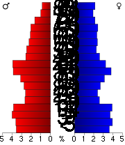
In the county the population was spread out with 27.60% under the age of 18, 7.80% from 18 to 24, 24.30% from 25 to 44, 21.70% from 45 to 64, and 18.60% who were 65 years of age or older. The median age was 39 years. For every 100 females there were 95.40 males. For every 100 females age 18 and over, there were 94.50 males.
The median income for a household in the county was $35,441, and the median income for a family was $42,321. Males had a median income of $29,242 versus $19,788 for females. The per capita income
Per capita income
Per capita income or income per person is a measure of mean income within an economic aggregate, such as a country or city. It is calculated by taking a measure of all sources of income in the aggregate and dividing it by the total population...
for the county was $16,413. About 7.80% of families and 9.80% of the population were below the poverty line, including 13.50% of those under age 18 and 8.80% of those age 65 or over.
Cities and towns
| Cities | Townships | Unincorporated | |
|---|---|---|---|
|
Long Lake Township, Watonwan County, Minnesota Long Lake Township is a township in Watonwan County, Minnesota, United States. The population was 346 at the 2000 census.-Geography:According to the United States Census Bureau, the township has a total area of 35.6 square miles , of which, 34.4 square miles of it is land and... |
|
Godahl, Minnesota Godahl is an unincorporated community in Brown and Watonwan counties in the U.S. state of Minnesota.-Location:Godahl sits on the boundary line for Brown and Watonwan, counties, occupying two counties. The community is located between Sleepy Eye and St. James on Minnesota State Highway 4... Sveadahl, Minnesota Sveadahl is an unincorporated community located in Watonwan County, Minnesota at latitude 44.074 and longitude -94.739 . The elevation is 1,073 feet. Sveadahl appears on the Godahl U.S. Geological Survey Map.... |
† Ormsby is located in both Watonwan and Martin County
Martin County, Minnesota
As of the census of 2000, there were 21,802 people, 9,067 households, and 6,047 families residing in the county. The population density was 31 people per square mile . There were 9,800 housing units at an average density of 14 per square mile...
.
See also
- National Register of Historic Places listings in Watonwan County, Minnesota