
Blanca Peak
Encyclopedia
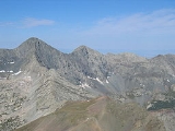
Blanca Peak is the highest peak of the Sierra Blanca Massif at the southern tip of the Sangre de Cristo Mountains
in the U.S. State of Colorado. It is the fourth highest peak of the Rocky Mountains
, and the eighth highest peak in the contiguous United States
.
, a subrange of the larger Sangre de Cristo Mountains
, and is the highest peak in both ranges. It marks the common boundary of Huerfano
, Costilla
and Alamosa
counties, approximately 20 miles (32 km) ENE of the town of Alamosa
. Approximately 15 miles (24 km) to the north-northwest is Great Sand Dunes National Park and Preserve
.
Blanca Peak is notable not only for its absolute height, but also for its great local relief and dominant position at the end of the range, rising high above the San Luis Valley
to the west. For example, it rises 6,600 ft (2011 m) over the edge of the San Luis Valley in only 6 mi (9.65 km).
Blanca is also the third most topographically prominent
peak in Colorado; it is separated from the higher peaks in the Sawatch Range
by relatively low Medano Pass (9,982 ft/3,043 m).
Blanca Peak heads up three major creeks. Holbrook Creek is on the west, flowing from a basin including Crater Lake, Blue Lakes, and Como Lake. An extremely challenging four wheel drive
road accesses Como Lake (11,750 ft/3,580 m), and provides the most common access to Blanca Peak. Most vehicles stop at an elevation of between 8,000 ft and 10,000 ft (2,440 m-3,050 m) on this road. The Como Lake Road is a designated Alamosa County Road and runs to the edge of the Sangre de Cristo Wilderness
just short of Blue Lakes. The Como Lake Road is rated as the most challenging 4WD road in Colorado. The Huerfano River
flows from the north side of Blanca Peak. A road, starting out as a two wheel drive road, then becoming a four wheel drive road (less challenging than the Como Lake Road), provides access to the technical climbing
on the North Face of Blanca Peak. Blanca Creek drains Blanca Basin under the south slopes of the peak, and Little Ute Creek descends from the Winchell Lakes on the southeast side. However these are not used to access the peak due to private property.
Three other fourteeners are nearby: Mount Lindsey
to the east, Ellingwood Point
to the north and Little Bear Peak
to the southwest. Ellingwood Point is connected to Blanca by a short, high ridge, and is often climbed in conjunction with Blanca. Little Bear also has a high connecting ridge to Blanca, but it is a technical
traverse, only recommended for highly experienced parties.
to the east and the Front Range
to the northeast are also pre-Cambrian, also about 1.8 billion years old. In contrast, the Sangre de Cristo Range
to the north and the Culebra Range to the south are Permian
rock between 250 and 300 million years old.
as the Sacred Mountain of the East: (or Tsisnaasjiní), the Dawn or White Shell Mountain. The mountain is considered to be the eastern boundary of the Dinetah
, the traditional Navajo homeland. It is associated with the color white, and is said to be covered in daylight and dawn and fastened to the ground with lightning. It is gendered male.
Summitpost notes that "the first recorded ascent of Blanca by the Wheeler Survey
was recorded on August 14, 1874, but to their surprise they found evidence of a stone structure possibly built by Ute Indians
or wandering Spaniards
."
Sangre de Cristo Mountains
The Sangre de Cristo Mountains are the southernmost subrange of the Rocky Mountains. They are located in southern Colorado and northern New Mexico in the United States...
in the U.S. State of Colorado. It is the fourth highest peak of the Rocky Mountains
Rocky Mountains
The Rocky Mountains are a major mountain range in western North America. The Rocky Mountains stretch more than from the northernmost part of British Columbia, in western Canada, to New Mexico, in the southwestern United States...
, and the eighth highest peak in the contiguous United States
Contiguous United States
The contiguous United States are the 48 U.S. states on the continent of North America that are south of Canada and north of Mexico, plus the District of Columbia....
.
Geography
It is located at the southern end of the Sangre de Cristo RangeSangre de Cristo Range
The Sangre de Cristo Range, called the East Range locally in the San Luis Valley, is a narrow mountain range of the Rocky Mountains running north and south along the east side of the Rio Grande Rift in southern Colorado in the United States...
, a subrange of the larger Sangre de Cristo Mountains
Sangre de Cristo Mountains
The Sangre de Cristo Mountains are the southernmost subrange of the Rocky Mountains. They are located in southern Colorado and northern New Mexico in the United States...
, and is the highest peak in both ranges. It marks the common boundary of Huerfano
Huerfano County, Colorado
Huerfano County is one of the 64 counties of the State of Colorado of the United States. The county was named for the Huerfano Butte, a local landmark. The county population was 7,862 at U.S. Census 2000...
, Costilla
Costilla County, Colorado
Costilla County is the ninth least populous of the 64 counties in the state of Colorado of the United States. The county population was 3,663 at U.S. Census 2000. The county seat is San Luis, the oldest town in Colorado.- History :...
and Alamosa
Alamosa County, Colorado
Alamosa County is one of the 64 counties of the state of Colorado of the United States. The county name is the Spanish language word for a "grove of cottonwood trees." The county population was 14,966 at U.S. Census 2000...
counties, approximately 20 miles (32 km) ENE of the town of Alamosa
Alamosa, Colorado
The city of Alamosa is a Home Rule Municipality that is the county seat and the most populous city of Alamosa County, Colorado, United States. The United States Census Bureau estimates that the city population was 8,682 in 2005...
. Approximately 15 miles (24 km) to the north-northwest is Great Sand Dunes National Park and Preserve
Great Sand Dunes National Park and Preserve
-Other features:The park also contains alpine lakes and tundra, six peaks over 13,000 feet in elevation, ancient spruce and pine forests, large stands of aspen and cottonwood, grasslands, and wetlands — all habitat for diverse wildlife and plant species.One of the most unusual features of...
.
Blanca Peak is notable not only for its absolute height, but also for its great local relief and dominant position at the end of the range, rising high above the San Luis Valley
San Luis Valley
The San Luis Valley is an extensive alpine valley in the U.S. states of Colorado and New Mexico covering approximately and sitting at an average elevation of above sea level. The valley sits atop the Rio Grande Rift and is drained to the south by the Rio Grande River, which rises in the San Juan...
to the west. For example, it rises 6,600 ft (2011 m) over the edge of the San Luis Valley in only 6 mi (9.65 km).
Blanca is also the third most topographically prominent
Topographic prominence
In topography, prominence, also known as autonomous height, relative height, shoulder drop , or prime factor , categorizes the height of the mountain's or hill's summit by the elevation between it and the lowest contour line encircling it and no higher summit...
peak in Colorado; it is separated from the higher peaks in the Sawatch Range
Sawatch Range
The Sawatch Range is a mountain range in central Colorado which includes eight of the twenty highest peaks in the Rocky Mountains, including Mount Elbert, at elevation, the highest peak in the Rockies....
by relatively low Medano Pass (9,982 ft/3,043 m).
Blanca Peak heads up three major creeks. Holbrook Creek is on the west, flowing from a basin including Crater Lake, Blue Lakes, and Como Lake. An extremely challenging four wheel drive
Four Wheel Drive
The Four Wheel Drive Auto Company, more often known as Four Wheel Drive or just FWD, was founded in 1909 in Clintonville, Wisconsin, as the Badger Four-Wheel Drive Auto Company by Otto Zachow and William Besserdich.-History:...
road accesses Como Lake (11,750 ft/3,580 m), and provides the most common access to Blanca Peak. Most vehicles stop at an elevation of between 8,000 ft and 10,000 ft (2,440 m-3,050 m) on this road. The Como Lake Road is a designated Alamosa County Road and runs to the edge of the Sangre de Cristo Wilderness
Sangre de Cristo Wilderness
The Sangre de Cristo Wilderness is a long and narrow wilderness area covering much of the Sangre de Cristo Range centered about Saguache County and Custer County, Colorado. Smaller areas are located in the counties of Fremont, Alamosa, and Huerfano. All of the wilderness area is located on U.S...
just short of Blue Lakes. The Como Lake Road is rated as the most challenging 4WD road in Colorado. The Huerfano River
Huerfano River
Huerfano River is a tributary of the Arkansas River that flows from a source near Blanca Peak in the Sangre de Cristo Mountains of Colorado. It joins the Arkansas in Pueblo County just south of the town of Boone....
flows from the north side of Blanca Peak. A road, starting out as a two wheel drive road, then becoming a four wheel drive road (less challenging than the Como Lake Road), provides access to the technical climbing
Rock climbing
Rock climbing also lightly called 'The Gravity Game', is a sport in which participants climb up, down or across natural rock formations or artificial rock walls. The goal is to reach the summit of a formation or the endpoint of a pre-defined route without falling...
on the North Face of Blanca Peak. Blanca Creek drains Blanca Basin under the south slopes of the peak, and Little Ute Creek descends from the Winchell Lakes on the southeast side. However these are not used to access the peak due to private property.
Three other fourteeners are nearby: Mount Lindsey
Mount Lindsey
Mount Lindsey is a fourteener in the US state of Colorado, located near Blanca Peak at the southern end of the Sangre de Cristo Range. It is the forty-third highest mountain in Colorado. The summit and most of the southern flank of the mountain are privately held, but access to the summit is allowed...
to the east, Ellingwood Point
Ellingwood Point
Ellingwood Point, or Ellingwood Peak, is a fourteener in the U.S. state of Colorado. It is located at the southern end of the Sangre de Cristo Range, approximately 1/2 mile northwest of Blanca Peak. It lies on the border between Alamosa County and Huerfano County...
to the north and Little Bear Peak
Little Bear Peak
Little Bear Peak, or simply Little Bear, is one of the fourteeners of the US state of Colorado. It lies at the southern end of the Sangre de Cristo Range, which is the northern section of the Sangre de Cristo Mountains. Little Bear is just southwest of Blanca Peak, one of the highest and most...
to the southwest. Ellingwood Point is connected to Blanca by a short, high ridge, and is often climbed in conjunction with Blanca. Little Bear also has a high connecting ridge to Blanca, but it is a technical
Rock climbing
Rock climbing also lightly called 'The Gravity Game', is a sport in which participants climb up, down or across natural rock formations or artificial rock walls. The goal is to reach the summit of a formation or the endpoint of a pre-defined route without falling...
traverse, only recommended for highly experienced parties.
Geology
The granite that makes up the Blanca massif is pre-Cambrian in age, dated at approximately 1.8 billion years old. The major part of the Wet MountainsWet Mountains
The Wet Mountains are a small range of mountains in southern Colorado named for the amount of snow they receive in the winter. There are three variant names of this range: Cuerno Verde, Greenhorn Mountains, and Sierra Mojadas...
to the east and the Front Range
Front Range
The Front Range is a mountain range of the Southern Rocky Mountains of North America located in the north-central portion of the U.S. State of Colorado and southeastern portion of the U.S. State of Wyoming. It is the first mountain range encountered moving west along the 40th parallel north across...
to the northeast are also pre-Cambrian, also about 1.8 billion years old. In contrast, the Sangre de Cristo Range
Sangre de Cristo Range
The Sangre de Cristo Range, called the East Range locally in the San Luis Valley, is a narrow mountain range of the Rocky Mountains running north and south along the east side of the Rio Grande Rift in southern Colorado in the United States...
to the north and the Culebra Range to the south are Permian
Permian
The PermianThe term "Permian" was introduced into geology in 1841 by Sir Sir R. I. Murchison, president of the Geological Society of London, who identified typical strata in extensive Russian explorations undertaken with Edouard de Verneuil; Murchison asserted in 1841 that he named his "Permian...
rock between 250 and 300 million years old.
History
Blanca Peak is known to the Navajo peopleNavajo people
The Navajo of the Southwestern United States are the largest single federally recognized tribe of the United States of America. The Navajo Nation has 300,048 enrolled tribal members. The Navajo Nation constitutes an independent governmental body which manages the Navajo Indian reservation in the...
as the Sacred Mountain of the East: (or Tsisnaasjiní), the Dawn or White Shell Mountain. The mountain is considered to be the eastern boundary of the Dinetah
Dinetah
Dinétah is the traditional homeland of the Navajo tribe of Native Americans. In the Navajo language, the word means "among the people" or "among the Navajo"...
, the traditional Navajo homeland. It is associated with the color white, and is said to be covered in daylight and dawn and fastened to the ground with lightning. It is gendered male.
Summitpost notes that "the first recorded ascent of Blanca by the Wheeler Survey
Wheeler Survey
The Wheeler Survey was a survey of a portion of the United States lying west of the 100th meridian. It comprised multiple expeditions, and was supervised by First Lieutenant George Montague Wheeler....
was recorded on August 14, 1874, but to their surprise they found evidence of a stone structure possibly built by Ute Indians
Ute Tribe
The Ute are an American Indian people now living primarily in Utah and Colorado. There are three Ute tribal reservations: Uintah-Ouray in northeastern Utah ; Southern Ute in Colorado ; and Ute Mountain which primarily lies in Colorado, but extends to Utah and New Mexico . The name of the state of...
or wandering Spaniards
New Spain
New Spain, formally called the Viceroyalty of New Spain , was a viceroyalty of the Spanish colonial empire, comprising primarily territories in what was known then as 'América Septentrional' or North America. Its capital was Mexico City, formerly Tenochtitlan, capital of the Aztec Empire...
."
See also
- List of Colorado fourteeners
- Mountain peaks of ColoradoMountain peaks of ColoradoThis article comprises three sortable tables of the major mountain peaks of the U.S. State of Colorado.Topographic elevation is the vertical distance above the reference geoid, a precise mathematical model of the Earth's sea level as an equipotential gravitational surface...
- Mountain ranges of ColoradoMountain ranges of ColoradoThe following table lists the major mountain ranges of the U.S. State of Colorado.-Mountain Ranges:-See also:*4000 meter peaks of Colorado*Colorado mountain passes*Geography of Colorado*Lists of mountains*Mountain peaks of Colorado...