
Big Bear Lake
Encyclopedia
Big Bear Lake is a reservoir
in the San Bernardino Mountains
, in San Bernardino County
, California
, United States
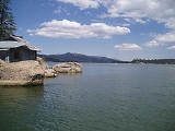
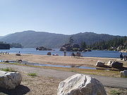
. At a surface elevation of 6750 ft (2,057.4 m), it has an east-west length of approximately 7 miles (11.2 km) and is approximately 2.5 miles (4 km) at its widest measurement, though the lake's width mostly averages a little more than 1 mile (1.6 km). These approximations are based on the lake having an optimum retainable water level. At dam's end Big Bear measures its deepest water at 72 feet (22 m). It is a completely snow-fed lake, having no other means of tributary or mechanical replenishment.
Located 100 miles (160.9 km) northeast of Los Angeles
and surrounded by the San Bernardino National Forest
, Big Bear Lake is accessible via three scenic highways: Highway 330
from San Bernardino, Highway 38
from Redlands, and Highway 18 from Victorville.
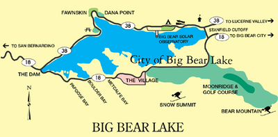 Big Bear Lake is geophysically defined by its North Shore and its South Shore. Big Bear Boulevard follows the South Shore and leads into the Big Bear Valley as a continuation of Highway 18 (the so-called Rim of the World Highway, which approaches from the west). Big Bear Boulevard winds east through Papoose Bay, Boulder Bay and Metcalf Bay, then leads directly east to the city of Big Bear Lake. At a point called The Village, the road turns toward the lake and then curves eastward to Moonridge, the ski resorts at Snow Summit and Bear Mountain, and Stanfield Cutoff, a causeway located near the east end of the lake. Big Bear Boulevard then continues east into Big Bear City
, which is an unincorporated community despite its name. Bear Creek
and Siberia Creek flow into the lake and Bear Creek flows out of the lake, traveling about 9 miles (14.5 km) southwest to the Santa Ana River
.
North Shore (Highway 38
) begins at the Dam Junction of Highway 18. It travels east past the historic location of Gray's Landing, a famous 1920s fishing camp. It turns north around Grout Bay and travels through the small unincorporated town of Fawnskin
. The road meanders across North Shore through Forestry lands, past the Big Bear Solar Observatory
, past the Big Bear Discovery Center, past the Serrano Campground (U.S.F.S), accessing the public boat launch, and Stanfield Cutoff. North Shore Drive continues east into Big Bear City and Baldwin Lake
.
The primary approach to Big Bear is via Highway 330
out of San Bernardino through Running Springs
where it intersects Highway 18. Highway 18 proceeds past Arrowbear and Snow Valley, over 7,200 ft (2,190 m) Lake Vista Summit and across the 15 mi (24 km) "Arctic Circle" for a total distance of 33 mi (53 km). Big Bear Lake can also be accessed by Hwy 38 (referred to as 'The Backside') at the San Bernardino (10) Freeway
near Redlands
, and takes a 52 mi (84 km) mile route that passes through Big Bear City on the east. From north of Lucerne Valley
, it can be accessed by Highway 18 over the pass into Baldwin Lake and through the north side, into Big Bear City.
 According to the National Weather Service, the warmest month at Big Bear is July, when the average high is 80.7 °F (27.1 °C) and the average low is 47.1 °F (8.4 °C). The coolest month is January, with an average high of 47.1 °F (8.4 °C) and an average low of 20.7 °F (-6.3 °C). There are an average of 1.2 days each year with highs of 90 °F (32 °C) or higher. Freezing temperatures have occurred in every month and occur on an average of 193.0 days each year. Lows of 0 °F (-18 °C) or lower average 1.1 days each year. The highest temperature recorded at Big Bear was 94 °F (34 °C), last recorded on July 15, 1998. The record lowest temperature was -25 °F (-32 °C), on January 29, 1979.
Due to the 6,790-7,200 foot (2,069 m) elevation of the weather station, precipitation is greater than in the lowlands of San Bernardino County, averaging 21.15 in (537.21 mm) a year. The maximum 24-hour precipitation was 9.43 in (239.52 mm) on December 6, 1966. Measurable precipitation normally occurs 44.9 days a year. Mountain thunderstorms occasionally produce heavy rainfall, even in midsummer (when most southern California lowland locations are quite dry).
In contrast to most of southern California, the Big Bear Lake region normally receives significant winter snow because of its high elevation. Snowfall, as measured at lake level, averages 61.8 inches (157 cm) each year (although upwards of 100 inches (254 cm) can accumulate on the forested ridges bordering the lake, above 8,000 feet (2,400 m)). In February 1990, 59.5 inches (151 cm) of snow were recorded. The most snow in 24 hours was 27.0 inches (69 cm) on March 27, 1991. The greatest snow depth was 58 inches (147 cm) on February 3, 1979. Snow has fallen in every month except July and August. There are normally 16.5 days each year with measurable snow (0.1 inch (2.5 mm) or more).
 The region now known as Big Bear Lake was populated by the indigenous
Serrano Indian
tribe for approximately 2,500 years. They referred to the territory as "Yuhaviat" which translates into "Pine Place". They inhabited small villages of 10 to 30 round buildings located along fresh water sources and subsisted on berries, nuts, tubers, acorns, and plentiful game harvested along the lush valley. The Serrano looked at the native grizzly bears as ancestors and did not eat the meat or wear the fur of these massive animals. Several contemporary communities in the area feature place names reflecting the Big Bear region's rich Native history. These include Yucaipa
, Cucamonga
, and Muscupiabe.
The Big Bear Lake area was first discovered by European settlers when an Indian-hunting party was formed by Benjamin Wilson. Wilson moved to California during the days of Mexican territorial Alta California. He married into the Spanish landholder family, the Yorbas, and bought a portion of Rancho Jurupa
(Riverside
) from Juan Bandini
. He became a local rancher statesman of great repute, especially for a European in Mexican California.
Wilson had signed on as Justice of the Peace of the Inland Territory and was commissioned by the territorial authorities to locate and pursue Native Americans suspected of raiding ranches in nearby Riverside. This group, led by the fierce Chief Walkara, drove the herd into the Lucerne Valley
on the north side of the San Bernardinos. Wilson gathered a posse of 44 men, 22 of whom he sent through the Cajon Pass
while he engineered a pincer movement with the other 22 men into the headwaters of the Santa Ana River
, effectively cutting the Utes off at the other end of Lucerne.
On the trip Wilson came upon a broad watershed teeming with wildlife, particularly bear. His posse immediately became a hunting party where the men were split into 11 pairs, each pair bringing back a bear hide. Wilson dubbed the grassy expanse "Bear Valley" and one of the nearby shallow seasonal marshes "Big Bear Lake". This same ephemeral feature is today called Baldwin Lake
after Elias J. "Lucky" Baldwin of Rancho Santa Anita
fame, who bought the nearby Gold Mountain Mine that was renamed for him in 1876. On Wilson's return trip (the posse had presumably lost interest in tracking renegade Indians), the party took 11 more bear pelts.
In 1859, the newly discovered valley became a venue for gold prospectors. Mr. William F. Holcomb
, a prospector from Indiana, moved to Los Angeles from the Northern California mines where he heard about the prospecting at Big Bear. He moved to Starvation Flats
, where he had little luck the first winter. Because of his marksmanship, he was hired by several of the other miners to hunt bear for meat. With his Indian companion, Holcomb tracked, shot and wounded a grizzly bear one ridge north of Bear Valley. There he noticed a vein of quartz flecked with gold. When this discovery was revealed, the Southern California gold rush was on, and Holcomb Valley
quickly became the largest populated area in San Bernardino County.
In 1884 marshy, nearly flat Bear Valley was dammed with a single arch granite impoundment, which held back some 25000 acre.ft of water for irrigation purposes in the Redlands area. In 1912 a 72 foot (22 m) multiple arch dam was constructed about 300 feet (91 m) downstream of the old dam and increased the lake capacity to 73000 acre.ft. A highway bridge (18) was built over the arches of the old dam, which still stands under water. Elevation at the surface is 6,750 feet (2,060 m), but this level fluctuates according to annual snowmelt and runoff. The dams are part of the Big Bear Municipal Water District.
The unregulated hunting of grizzly bear in the San Bernardinos took a heavy toll upon the once significant native population, and Ursus californicus was extirpated locally by 1906.
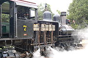 Logging in the San Bernardino Mountains was once done on a large scale, with the Brookings Lumber Company operation the largest. It operated on 8000 acres (32.4 km²) between Fredalba and Hunsaker Flats (present-day Running Springs), and extending northward to Heap's Ranch and Lightningdale (near Green Valley Lake) between 1899 and 1912. It built a logging railroad to bring logs to the mill at Fredalba. The Shay locomotives
had to be disassembled and hauled by wagon up the mountain, since the railroad operated in the high country but did not connect to other railroads in the lowlands. About 60% of the finished lumber was hauled by wagon down the steep grades to the Molino box factory in Highland, CA, which made packing crates for the citrus grown in the area. The remaining 40% went to the company's retail lumber yard in San Bernardino. In 1912, the company dismantled the Fredalba sawmill and moved much of the machinery to Brookings, Oregon
.
Tourism began with the onset of the automobile and the eventual establishment of highways accessing the seemingly remote area. Hollywood soon discovered Big Bear, and several movies, particularly westerns, have been filmed in the region.
Many lakeside residents have private docks, and visiting boaters obtain mooring in several of the marinas found on both shores. Big Bear Municipal Water District (a special district of the State of California) provides public launches on the east end and west end of North Shore. Local marinas rent various sport and pleasure boats, and parasailing is available.
North Shore (west to east)
South Shore (west to east)
Reservoir
A reservoir , artificial lake or dam is used to store water.Reservoirs may be created in river valleys by the construction of a dam or may be built by excavation in the ground or by conventional construction techniques such as brickwork or cast concrete.The term reservoir may also be used to...
in the San Bernardino Mountains
San Bernardino Mountains
The San Bernardino Mountains are a short transverse mountain range north and east of San Bernardino in Southern California in the United States. The mountains run for approximately 60 miles east-west on the southern edge of the Mojave Desert in southwestern San Bernardino County, north of the...
, in San Bernardino County
San Bernardino County, California
San Bernardino County is a county in the U.S. state of California. As of the 2010 census, the population was 2,035,210, up from 1,709,434 as of the 2000 census...
, California
California
California is a state located on the West Coast of the United States. It is by far the most populous U.S. state, and the third-largest by land area...
, United States
United States
The United States of America is a federal constitutional republic comprising fifty states and a federal district...
. At a surface elevation of 6750 ft (2,057.4 m), it has an east-west length of approximately 7 miles (11.2 km) and is approximately 2.5 miles (4 km) at its widest measurement, though the lake's width mostly averages a little more than 1 mile (1.6 km). These approximations are based on the lake having an optimum retainable water level. At dam's end Big Bear measures its deepest water at 72 feet (22 m). It is a completely snow-fed lake, having no other means of tributary or mechanical replenishment.
Located 100 miles (160.9 km) northeast of Los Angeles
Los Ángeles
Los Ángeles is the capital of the province of Biobío, in the commune of the same name, in Region VIII , in the center-south of Chile. It is located between the Laja and Biobío rivers. The population is 123,445 inhabitants...
and surrounded by the San Bernardino National Forest
San Bernardino National Forest
San Bernardino National Forest is a federally-managed forest covering more than 800,000 acres . There are two main divisions which are the San Bernardino Mountains on the easternmost of the Transverse Range, and the San Jacinto and Santa Rosa Mountains on the northernmost of the Peninsular...
, Big Bear Lake is accessible via three scenic highways: Highway 330
California State Route 330
State Route 330 is a state highway in the U.S. state of California. It is also known as City Creek Road in the San Bernardino Mountains.-Route description:...
from San Bernardino, Highway 38
California State Route 38
State Route 38 is a mostly rural and scenic road in the U.S. state of California. Despite the orientation of its alignment, SR 38 is assigned in a west–east direction.-Route description:...
from Redlands, and Highway 18 from Victorville.
Defining surroundings
Big Bear City, California
Big Bear City is an unincorporated, census-designated place in San Bernardino County, California immediately east of Big Bear Lake. The population was 12,304 at the 2010 census, up from 5,779 at the 2000 census...
, which is an unincorporated community despite its name. Bear Creek
Bear Creek (Santa Ana River)
Bear Creek is an approximately tributary of the Santa Ana River in the San Bernardino Mountains of the U.S. state of California. Its length is entirely contained within San Bernardino County. It rises near Woodlands and flows north into Baldwin Lake...
and Siberia Creek flow into the lake and Bear Creek flows out of the lake, traveling about 9 miles (14.5 km) southwest to the Santa Ana River
Santa Ana River
The Santa Ana River is the largest river of Southern California in the United States. Its drainage basin spans four counties. It rises in the San Bernardino Mountains and flows past the cities of San Bernardino and Riverside, before cutting through the northern tip of the Santa Ana Mountains and...
.
North Shore (Highway 38
California State Route 38
State Route 38 is a mostly rural and scenic road in the U.S. state of California. Despite the orientation of its alignment, SR 38 is assigned in a west–east direction.-Route description:...
) begins at the Dam Junction of Highway 18. It travels east past the historic location of Gray's Landing, a famous 1920s fishing camp. It turns north around Grout Bay and travels through the small unincorporated town of Fawnskin
Fawnskin, California
Fawnskin is an unincorporated community in San Bernardino County, California, United States. Its altitude is 6,827 feet . The community has a post office, which was established on 18 May 1918.-History:...
. The road meanders across North Shore through Forestry lands, past the Big Bear Solar Observatory
Big Bear Solar Observatory
The Big Bear Solar Observatory is an astronomical telescopic observatory with main interests in studying the physics of the Sun. The instruments and telescopes of the observatory are designed and employed specifically for studying the activities and phenomena of our solar system's star...
, past the Big Bear Discovery Center, past the Serrano Campground (U.S.F.S), accessing the public boat launch, and Stanfield Cutoff. North Shore Drive continues east into Big Bear City and Baldwin Lake
Baldwin Lake, California
Baldwin Lake is a natural, intermittent, alkali lake in a valley of the San Bernardino Mountains, in San Bernardino County, California. The depth of Baldwin Lake's lowest point is approximately 25 feet . At its widest, the lake is more than a mile across...
.
The primary approach to Big Bear is via Highway 330
California State Route 330
State Route 330 is a state highway in the U.S. state of California. It is also known as City Creek Road in the San Bernardino Mountains.-Route description:...
out of San Bernardino through Running Springs
Running Springs, California
Running Springs is a census-designated place in San Bernardino County, California, United States. The population was 4,862 at the 2010 census, down from 5,125 at the 2000 census.-Geography:Running Springs is located at ....
where it intersects Highway 18. Highway 18 proceeds past Arrowbear and Snow Valley, over 7,200 ft (2,190 m) Lake Vista Summit and across the 15 mi (24 km) "Arctic Circle" for a total distance of 33 mi (53 km). Big Bear Lake can also be accessed by Hwy 38 (referred to as 'The Backside') at the San Bernardino (10) Freeway
Interstate 10 in California
Interstate 10 , the major east–west Interstate Highway in the Southern United States, runs in the U.S. state of California east from Santa Monica, on the Pacific Ocean, through Los Angeles and San Bernardino to the border with Arizona...
near Redlands
Redlands, California
Redlands is a city in San Bernardino County, California, United States. As of the 2010 census, the city had a population of 68,747, up from 63,591 at the 2000 census. The city is located east of downtown San Bernardino.- History :...
, and takes a 52 mi (84 km) mile route that passes through Big Bear City on the east. From north of Lucerne Valley
Lucerne Valley, California
Lucerne Valley is a census-designated place located in the Mojave Desert of western San Bernardino County, California. It lies east of the Victor Valley, whose population nexus includes Victorville, Apple Valley, and Hesperia...
, it can be accessed by Highway 18 over the pass into Baldwin Lake and through the north side, into Big Bear City.
Climate
Due to the 6,790-7,200 foot (2,069 m) elevation of the weather station, precipitation is greater than in the lowlands of San Bernardino County, averaging 21.15 in (537.21 mm) a year. The maximum 24-hour precipitation was 9.43 in (239.52 mm) on December 6, 1966. Measurable precipitation normally occurs 44.9 days a year. Mountain thunderstorms occasionally produce heavy rainfall, even in midsummer (when most southern California lowland locations are quite dry).
In contrast to most of southern California, the Big Bear Lake region normally receives significant winter snow because of its high elevation. Snowfall, as measured at lake level, averages 61.8 inches (157 cm) each year (although upwards of 100 inches (254 cm) can accumulate on the forested ridges bordering the lake, above 8,000 feet (2,400 m)). In February 1990, 59.5 inches (151 cm) of snow were recorded. The most snow in 24 hours was 27.0 inches (69 cm) on March 27, 1991. The greatest snow depth was 58 inches (147 cm) on February 3, 1979. Snow has fallen in every month except July and August. There are normally 16.5 days each year with measurable snow (0.1 inch (2.5 mm) or more).
History
Native Americans in the United States
Native Americans in the United States are the indigenous peoples in North America within the boundaries of the present-day continental United States, parts of Alaska, and the island state of Hawaii. They are composed of numerous, distinct tribes, states, and ethnic groups, many of which survive as...
Serrano Indian
Serrano (people)
The Serrano are a Native American tribe of present day California, United States. They use the autonyms of Taaqtam, meaning "people"; Maarenga'yam, "people from Morongo"; and Yuhaviatam, "people of the pines." The Serrano historically populated the San Bernardino Mountains and extended east into...
tribe for approximately 2,500 years. They referred to the territory as "Yuhaviat" which translates into "Pine Place". They inhabited small villages of 10 to 30 round buildings located along fresh water sources and subsisted on berries, nuts, tubers, acorns, and plentiful game harvested along the lush valley. The Serrano looked at the native grizzly bears as ancestors and did not eat the meat or wear the fur of these massive animals. Several contemporary communities in the area feature place names reflecting the Big Bear region's rich Native history. These include Yucaipa
Yucaipa, California
Yucaipa is a city located east of San Bernardino, in San Bernardino County, California, United States. The population was 51,367 at the 2010 census, up from 41,207 at the 2000 census...
, Cucamonga
Cucamonga, California
Cucamonga is the southern district of Rancho Cucamonga, California.-Education:School districts in Cucamonga include Cucamonga School District and Central School District.Some schools in the CSD also serve Ontario, California.-Elementary:...
, and Muscupiabe.
The Big Bear Lake area was first discovered by European settlers when an Indian-hunting party was formed by Benjamin Wilson. Wilson moved to California during the days of Mexican territorial Alta California. He married into the Spanish landholder family, the Yorbas, and bought a portion of Rancho Jurupa
Rancho Jurupa
Rancho Jurupa was a Mexican land grant in California, United States, that is divided by the present-day counties of Riverside and San Bernardino. The land was granted to Juan Bandini by Governor Juan B. Alvarado in 1838...
(Riverside
Riverside, California
Riverside is a city in Riverside County, California, United States, and the county seat of the eponymous county. Named for its location beside the Santa Ana River, it is the largest city in the Riverside-San Bernardino-Ontario metropolitan area of Southern California, 4th largest inland California...
) from Juan Bandini
Juan Bandini
Juan Bandini was an early settler of what would become San Diego, California.-Early history:Juan Bandini was born 1800 in Lima, Peru to José Bandini, a Spanish sea captain. His father came to California in 1819 and 1821 and participated in the Mexican War of Independence...
. He became a local rancher statesman of great repute, especially for a European in Mexican California.
Wilson had signed on as Justice of the Peace of the Inland Territory and was commissioned by the territorial authorities to locate and pursue Native Americans suspected of raiding ranches in nearby Riverside. This group, led by the fierce Chief Walkara, drove the herd into the Lucerne Valley
Lucerne Valley, California
Lucerne Valley is a census-designated place located in the Mojave Desert of western San Bernardino County, California. It lies east of the Victor Valley, whose population nexus includes Victorville, Apple Valley, and Hesperia...
on the north side of the San Bernardinos. Wilson gathered a posse of 44 men, 22 of whom he sent through the Cajon Pass
Cajon Pass
Cajon Pass is a moderate-elevation mountain pass between the San Bernardino Mountains and the San Gabriel Mountains in Southern California in the United States. It was created by the movements of the San Andreas Fault...
while he engineered a pincer movement with the other 22 men into the headwaters of the Santa Ana River
Santa Ana River
The Santa Ana River is the largest river of Southern California in the United States. Its drainage basin spans four counties. It rises in the San Bernardino Mountains and flows past the cities of San Bernardino and Riverside, before cutting through the northern tip of the Santa Ana Mountains and...
, effectively cutting the Utes off at the other end of Lucerne.
On the trip Wilson came upon a broad watershed teeming with wildlife, particularly bear. His posse immediately became a hunting party where the men were split into 11 pairs, each pair bringing back a bear hide. Wilson dubbed the grassy expanse "Bear Valley" and one of the nearby shallow seasonal marshes "Big Bear Lake". This same ephemeral feature is today called Baldwin Lake
Baldwin Lake, California
Baldwin Lake is a natural, intermittent, alkali lake in a valley of the San Bernardino Mountains, in San Bernardino County, California. The depth of Baldwin Lake's lowest point is approximately 25 feet . At its widest, the lake is more than a mile across...
after Elias J. "Lucky" Baldwin of Rancho Santa Anita
Rancho Santa Anita
Rancho Santa Anita was a land grant in present day Los Angeles County, California given to Perfecto Hugo Reid. The land grant was formally recognized by Governor Pio Pico in 1845. The land grant covered all or portions of the present day cities of Arcadia, Monrovia, Sierra Madre, Pasadena and San...
fame, who bought the nearby Gold Mountain Mine that was renamed for him in 1876. On Wilson's return trip (the posse had presumably lost interest in tracking renegade Indians), the party took 11 more bear pelts.
In 1859, the newly discovered valley became a venue for gold prospectors. Mr. William F. Holcomb
William F. Holcomb
William Francis "Grizzly Bill" Holcomb , was an American prospector and the first to discover gold in the region which became known as Holcomb Valley, near present-day Big Bear Lake, California. Holcomb Valley had the most gold of any Southern California field. The boomtown of Belleville grew up...
, a prospector from Indiana, moved to Los Angeles from the Northern California mines where he heard about the prospecting at Big Bear. He moved to Starvation Flats
Starvation Flats
Starvation Flats is an area in the San Bernardino Mountains near Big Bear Lake, California. It was originally a settlement of the Native American Serrano people for thousands of years.-History:...
, where he had little luck the first winter. Because of his marksmanship, he was hired by several of the other miners to hunt bear for meat. With his Indian companion, Holcomb tracked, shot and wounded a grizzly bear one ridge north of Bear Valley. There he noticed a vein of quartz flecked with gold. When this discovery was revealed, the Southern California gold rush was on, and Holcomb Valley
Holcomb Valley
Holcomb Valley, located in the San Bernardino Mountains about five miles north of Big Bear Lake, was the site of the most gold mined in Southern California. It was named after William F. Holcomb, who discovered gold there in 1860. That year started the largest gold rush in Southern California to...
quickly became the largest populated area in San Bernardino County.
In 1884 marshy, nearly flat Bear Valley was dammed with a single arch granite impoundment, which held back some 25000 acre.ft of water for irrigation purposes in the Redlands area. In 1912 a 72 foot (22 m) multiple arch dam was constructed about 300 feet (91 m) downstream of the old dam and increased the lake capacity to 73000 acre.ft. A highway bridge (18) was built over the arches of the old dam, which still stands under water. Elevation at the surface is 6,750 feet (2,060 m), but this level fluctuates according to annual snowmelt and runoff. The dams are part of the Big Bear Municipal Water District.
The unregulated hunting of grizzly bear in the San Bernardinos took a heavy toll upon the once significant native population, and Ursus californicus was extirpated locally by 1906.
Shay locomotive
The Shay locomotive was the most widely used geared steam locomotive. The locomotives were built to the patents of Ephraim Shay, who has been credited with the popularization of the concept of a geared steam locomotive...
had to be disassembled and hauled by wagon up the mountain, since the railroad operated in the high country but did not connect to other railroads in the lowlands. About 60% of the finished lumber was hauled by wagon down the steep grades to the Molino box factory in Highland, CA, which made packing crates for the citrus grown in the area. The remaining 40% went to the company's retail lumber yard in San Bernardino. In 1912, the company dismantled the Fredalba sawmill and moved much of the machinery to Brookings, Oregon
Brookings, Oregon
Brookings is a city in Curry County, Oregon, United States. It was named after John E. Brookings, president of the Brookings Lumber and Box Company, which founded the city in 1908. As of the 2010 census the population was 6,336. The total population of the Brookings area is over 13,000, which...
.
Tourism began with the onset of the automobile and the eventual establishment of highways accessing the seemingly remote area. Hollywood soon discovered Big Bear, and several movies, particularly westerns, have been filmed in the region.
Lake activities
Big Bear Lake provides an attractive setting for many outdoor activities, including fishing (trout, bluegill, crappie, catfish and largemouth bass), pleasure boating, and water skiing. Because of the very cold water and the presence of underwater obstacles near the shorelines, swimming is discouraged. The lake is patrolled by the BBMWD Lake Patrol.Many lakeside residents have private docks, and visiting boaters obtain mooring in several of the marinas found on both shores. Big Bear Municipal Water District (a special district of the State of California) provides public launches on the east end and west end of North Shore. Local marinas rent various sport and pleasure boats, and parasailing is available.
Points of interest
- Big Bear Dam
North Shore (west to east)
- FawnskinFawnskin, CaliforniaFawnskin is an unincorporated community in San Bernardino County, California, United States. Its altitude is 6,827 feet . The community has a post office, which was established on 18 May 1918.-History:...
(San Bernardino County uninc.) - Captain John's Marina
- Big Bear Solar ObservatoryBig Bear Solar ObservatoryThe Big Bear Solar Observatory is an astronomical telescopic observatory with main interests in studying the physics of the Sun. The instruments and telescopes of the observatory are designed and employed specifically for studying the activities and phenomena of our solar system's star...
(New Jersey Institute of Technology) - Big Bear Discovery Centerhttp://www.bigbeardiscoverycenter.com/
- Serrano Campground (USFS)
- Juniper Point
- Duane Boyer and Carol Morrison Public Launch Ramps
South Shore (west to east)
- China Island (proper name Garstin Island)
- Boulder Bay
- Metcalf Bay and Holloway's Landing
- Alpine amusement park (bunny slope in winter; slides and water park in summer)
- The Village (Village Drive and Pine Knot Avenue: Theaters, shopping, restaurants and the Super Bear Arcade)
- Pine Knot Marina
- Snow SummitSnow SummitSnow Summit is a ski resort that was established in 1952 and is in the San Bernardino Mountains in Southern California. It is located by Big Bear Lake along with its sister resort Bear Mountain; these two resorts which operate under the same management are collectively known as Big Bear Mountain...
(skiing; snowboarding; mountain biking in summer; ski lift open in summer for sightseeing) - Moonridge Golf Course
- Big Bear Zoo (in Moonridge)
- Bear Mountain (Ski Area)Bear Mountain (Ski Area)Bear Mountain , formerly Goldmine Mountain, is a ski area in Southern California. It is the sister resort of Snow Summit, together known as Big Bear Mountain Resorts. In 2002 Bear Mountain was purchased by Snow Summit, and the two resorts are now accessible with a single lift ticket...
(skiing and snowboarding in winter; golfcourse in summer) - Big Bear Trout Pond
- Big Bear Lake Interlaken shopping center (consists of several chain stores and markets)
See also
- Big Bear Lake, CaliforniaBig Bear Lake, CaliforniaBig Bear Lake is a city in San Bernardino County, California along the south shore of Big Bear Lake, located northeast of the city of San Bernardino. The population was 5,019 at the 2010 census, down from 5,438 at the 2000 census...
, for the incorporated city - Big Bear City, CaliforniaBig Bear City, CaliforniaBig Bear City is an unincorporated, census-designated place in San Bernardino County, California immediately east of Big Bear Lake. The population was 12,304 at the 2010 census, up from 5,779 at the 2000 census...
, an unincorporated town east of Big Bear Lake - List of people from Big Bear Lake, CA
External links
- Current Lake Info
- Off-Road Trails around Big Bear Lake
- Big Bear Discovery Center
- KBHR Radio 93.3 FM for Big Bear news, weather and road conditions
- Big Bear Grizzly, in depth news, sports and entertainment information
- Big Bear Lake Lodging, Dining, and Activity Information
- Rim of the World Historical Society Web site
- Big Bear Valley Historical Museum Web site