Betuwe
Encyclopedia

Netherlands
The Netherlands is a constituent country of the Kingdom of the Netherlands, located mainly in North-West Europe and with several islands in the Caribbean. Mainland Netherlands borders the North Sea to the north and west, Belgium to the south, and Germany to the east, and shares maritime borders...
in the province of Gelderland
Gelderland
Gelderland is the largest province of the Netherlands, located in the central eastern part of the country. The capital city is Arnhem. The two other major cities, Nijmegen and Apeldoorn have more inhabitants. Other major regional centers in Gelderland are Ede, Doetinchem, Zutphen, Tiel, Wijchen,...
. Tacitus knew it as Insula Batavorum ("Island of the Batavians
Batavians
The Batavi were an ancient Germanic tribe, originally part of the Chatti, reported by Tacitus to have lived around the Rhine delta, in the area that is currently the Netherlands, "an uninhabited district on the extremity of the coast of Gaul, and also of a neighbouring island, surrounded by the...
," the Germanic tribe from which the modern name is derived) and indeed it could be considered a large river
River
A river is a natural watercourse, usually freshwater, flowing towards an ocean, a lake, a sea, or another river. In a few cases, a river simply flows into the ground or dries up completely before reaching another body of water. Small rivers may also be called by several other names, including...
island
Island
An island or isle is any piece of sub-continental land that is surrounded by water. Very small islands such as emergent land features on atolls can be called islets, cays or keys. An island in a river or lake may be called an eyot , or holm...
, but nowadays it hardly ever is viewed as such (with the exception of the last months of World War II
World War II
World War II, or the Second World War , was a global conflict lasting from 1939 to 1945, involving most of the world's nations—including all of the great powers—eventually forming two opposing military alliances: the Allies and the Axis...
(October 1944 - June 1945) when it became known as "Men's Island" or "Manneneiland" due to the evacuation of all civilian population during Operation Market Garden
Operation Market Garden
Operation Market Garden was an unsuccessful Allied military operation, fought in the Netherlands and Germany in the Second World War. It was the largest airborne operation up to that time....
, leaving only soldiers behind). When the Pannerdens Kanaal
Pannerdens Kanaal
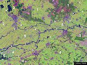
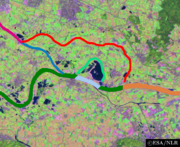
thumb|300px|right|Processed [[satellite]] [[image]] of the [[Rhine]]-[[Waal |Waal]] fork showing the location of the Pannerdens Kanaal .The Pannerdens Kanaal is a canal in the Netherlands that was dredged between 1701 and 1709 to cut off a large, shallow bend of river Rhine and so improve river...
was dug between 1701 and 1709, the easternmost tip of the Betuwe (including the towns of Pannerden
Pannerden
Pannerden is a village in the Dutch province of Gelderland. It is located in the municipality of Rijnwaarden.Pannerden was a separate municipality from 1818 to 1985, when it became a part of the new municipality of Rijnwaarden.-External links:*...
and Lobith
Lobith
Lobith is a village in the Dutch province of Gelderland. It is located in the municipality of Rijnwaarden. Traditionally, it is said that the Rhine enters the Netherlands at Lobith, although in reality, this happens about 4 km further upstream, near Spijk....
) was cut off from the rest of the region.
The Betuwe is situated between the Waal and Rhine/Lek
Lek River
The Lek is a river in the western Netherlands of some 60 km in length. It is the continuation of the Nederrijn after the Kromme Rijn branches off at the town of Wijk bij Duurstede. The main westbound waterway is hereafter called the Lek River...
river
River
A river is a natural watercourse, usually freshwater, flowing towards an ocean, a lake, a sea, or another river. In a few cases, a river simply flows into the ground or dries up completely before reaching another body of water. Small rivers may also be called by several other names, including...
s, surrounding the beautiful Linge
Linge
Linge is a river in the Betuwe that is over 100 km long, which makes it one of the longest rivers that flow entirely within the Netherlands.It starts near the village Doornenburg near the German border. A legend tells us that if there will be no more pigs grazing at the castle of Doornenburg, the...
stream, and is famous for its fruit
Fruit
In broad terms, a fruit is a structure of a plant that contains its seeds.The term has different meanings dependent on context. In non-technical usage, such as food preparation, fruit normally means the fleshy seed-associated structures of certain plants that are sweet and edible in the raw state,...
production. The largest and most important city in the area is Tiel
Tiel
' is a municipality and a town in the middle of the Netherlands.The town is enclosed by the Waal river and the Linge river on the south and the north side, and the Amsterdam-Rhine Canal on the east side. The city was founded in the 5th century AD....
.

A major freight railroad, the Betuweroute
Betuweroute
The Betuweroute is a double track freight railway from Rotterdam to Germany. Betuweroute is the official name, after the Betuwe area through which it passes, but the line is popularly referred to as Betuwelijn, after an older track in the same region. The Germans have named their part the...
, passes through the Betuwe. It was opened in 2007 after many years of controversy.
Towns and villages in the Betuwe are:
- AngerenAngerenAngeren is a village in the Netherlands in the municipality of Lingewaard. It has a population of 2,851 , and is located in the very eastern tip of the Betuwe, 2 km to the south of Huissen, between the cities of Arnhem and Nijmegen.Angeren is first mentioned as Angrina in a document dated 814...
- BurenBurenBuren is a municipality and a city in the eastern Netherlands. It is also a county; with the Dutch Monarch still holding the title "Count of Buren".- Population centres :...
- CulemborgCulemborgCulemborg is a municipality and a city in the centre of the Netherlands. The city is situated just south of the Lek River...
- DrielDrielDriel is a town in the municipality of Overbetuwe, approximately four kilometers southwest of Arnhem on the south bank of the Rhine, in the Netherlands.-History:...
- ElstElstElst is the name of a number of towns:*Elst; a village and former municipality, now part of Overbetuwe, in Gelderland*Elst; a village in the municipality of Rhenen, in the province of Utrecht*Elst; a village in the municipality of Maasdonk, in North Brabant...
- GeldermalsenGeldermalsenGeldermalsen is a municipality and a town in the western Netherlands. The municipality of Geldermalsen was formed on the 1st of January 1978 when former municipalities Beesd, Buurmalsen, Deil and Geldermalsen were joined. The new municipality with approximately 10.173 hectares is one of the...
- GendtGendtGendt is a city in Gelderland in the municipality of Lingewaard. It was previously a municipality of its own, but in 2001 it merged with Huissen and Bemmel to form the new municipality Lingewaard. The city is located on the river Waal, about 5 km northeast of the city of Nijmegen. It received...
- HuissenHuissenHuissen is a town in Gelderland, Netherlands and has about 17,000 inhabitants. It is located at the Nederrijn, in the area between Arnhem and Nijmegen...
- Randwijk
- TielTiel' is a municipality and a town in the middle of the Netherlands.The town is enclosed by the Waal river and the Linge river on the south and the north side, and the Amsterdam-Rhine Canal on the east side. The city was founded in the 5th century AD....
- TuyllTuyllTuyll is the name of a noble Dutch family, with familial and historical links to England, whose full name is van Tuyll van Serooskerken. Several knights, members of various courts, literary figures, generals, ambassadors, statesmen and explorers carried the family name.-Early and High Middle...
or Tuil, seat of the court of the Middle Ages region of Teisterbant, which included today's Betuwe
The Betuwe region is divided into 11 municipalities
Municipality
A municipality is essentially an urban administrative division having corporate status and usually powers of self-government. It can also be used to mean the governing body of a municipality. A municipality is a general-purpose administrative subdivision, as opposed to a special-purpose district...
: Overbetuwe
Overbetuwe
Overbetuwe is a municipality in the province of Gelderland in the Netherlands. It was formed on 1 January 2001 as a merger of three former municipalities: Elst, Heteren and Valburg. Overbetuwe is bordered in the north by the river Rhine and in the south by the river Waal. The city hall is located...
, Neder-Betuwe
Neder-Betuwe
Neder-Betuwe is a municipality in the eastern Netherlands.-Geography:The municipal boundaries are for a large part defined by the river Waal to the south, the river Rhine to the North and the Amsterdam-Rhine Canal to the west...
, Lingewaard
Lingewaard
Lingewaard is a municipality in the eastern Netherlands. It is located in the most eastern part of the Betuwe. It was formed in 2001 as a merger between Bemmel, Gendt and Huissen...
, Arnhem
Arnhem
Arnhem is a city and municipality, situated in the eastern part of the Netherlands. It is the capital of the province of Gelderland and located near the river Nederrijn as well as near the St. Jansbeek, which was the source of the city's development. Arnhem has 146,095 residents as one of the...
(southern part), Nijmegen (northern part), Tiel
Tiel
' is a municipality and a town in the middle of the Netherlands.The town is enclosed by the Waal river and the Linge river on the south and the north side, and the Amsterdam-Rhine Canal on the east side. The city was founded in the 5th century AD....
, Culemborg
Culemborg
Culemborg is a municipality and a city in the centre of the Netherlands. The city is situated just south of the Lek River...
, Neerijnen
Neerijnen
Neerijnen is a municipality and a town in the Netherlands. It is about 35 km south of Utrecht and some 15 km north of 's-Hertogenbosch.- Population centres :...
, Geldermalsen
Geldermalsen
Geldermalsen is a municipality and a town in the western Netherlands. The municipality of Geldermalsen was formed on the 1st of January 1978 when former municipalities Beesd, Buurmalsen, Deil and Geldermalsen were joined. The new municipality with approximately 10.173 hectares is one of the...
, Lingewaal
Lingewaal
Lingewaal is a municipality in the middle of the Netherlands.-External links:**----...
& Buren
Buren
Buren is a municipality and a city in the eastern Netherlands. It is also a county; with the Dutch Monarch still holding the title "Count of Buren".- Population centres :...
.
----
"De Betuwe" is also the name of a jam factory in the town of Tiel
Tiel
' is a municipality and a town in the middle of the Netherlands.The town is enclosed by the Waal river and the Linge river on the south and the north side, and the Amsterdam-Rhine Canal on the east side. The city was founded in the 5th century AD....
. The factory became famous because of its merchandise in which a figure called Flipje was starring. Every object related to Flipje has become a collector's item in the Netherlands
Netherlands
The Netherlands is a constituent country of the Kingdom of the Netherlands, located mainly in North-West Europe and with several islands in the Caribbean. Mainland Netherlands borders the North Sea to the north and west, Belgium to the south, and Germany to the east, and shares maritime borders...
.

