

Berney Arms
Encyclopedia
River Yare
The River Yare is a river in the English county of Norfolk. In its lower reaches the river connects with the navigable waterways of The Broads....
, close to Breydon Water
Breydon Water
Breydon Water is a massive stretch of sheltered estuary at Great Yarmouth in Norfolk, England. It is at gateway to the Norfolk Broads. It is the UK's largest protected wetland. It is 5 km long and more than 1.5 km wide in places...
in the English
England
England is a country that is part of the United Kingdom. It shares land borders with Scotland to the north and Wales to the west; the Irish Sea is to the north west, the Celtic Sea to the south west, with the North Sea to the east and the English Channel to the south separating it from continental...
county of Norfolk
Norfolk
Norfolk is a low-lying county in the East of England. It has borders with Lincolnshire to the west, Cambridgeshire to the west and southwest and Suffolk to the south. Its northern and eastern boundaries are the North Sea coast and to the north-west the county is bordered by The Wash. The county...
. It is part of the civil parish of Reedham
Reedham, Norfolk
Reedham is a village and civil parish in the English county of Norfolk and within The Broads. It is situated on the north bank of the River Yare, some east of the city of Norwich, south-west of the town of Great Yarmouth and the same distance north-west of the Suffolk town of Lowestoft.The Romans...
, is administered by the district
Non-metropolitan district
Non-metropolitan districts, or colloquially shire districts, are a type of local government district in England. As created, they are sub-divisions of non-metropolitan counties in a so-called "two-tier" arrangement...
of Broadland
Broadland
Broadland is a local government district in Norfolk, England, named after the Norfolk Broads. Its council is based in Thorpe St Andrew, which is a suburb of the City of Norwich.-History:The district was formed on April 1, 1974 by the merger of St...
and lies within The Broads National Park. It comprises a railway station, a windpump, a public house and a farm, but no longer has any inhabited houses.
Berney Arms can be reached only by train, by boat or on foot; there is no road access. Berney Arms railway station
Berney Arms railway station
Berney Arms railway station is a halt serving the remote settlement of Berney Arms in the Halvergate Marshes, in the English county of Norfolk.The station, which is from the nearest road, is the most remote station in Norfolk...
is a request stop
Request stop
In public transport, a request stop or flag stop describes a stopping point at which trains or buses stop only on an as-need or request basis; that is, only if there are passengers to be picked up or dropped off. In this way, infrequently used stopping points can be served efficiently.Trains save...
on the Norwich-Great Yarmouth via Reedham line
Wherry Lines
The Wherry Lines are railway lines in England, from Norwich to Great Yarmouth and Lowestoft. These lines pass through The Broads. The line is part of the Network Rail Strategic Route 7, SRS 07.11 and is classified as a rural line...
, although only two trains in each direction are timetabled to run this way Monday to Saturday, with more services running on Sundays. Access on foot involves walking the 3½ miles from Halvergate
Halvergate
Halvergate is a civil parish in the English county of Norfolk, north of Reedham., halfway between the Rivers Bure and Yare, within The Broads National Park.It covers an area of and had a population of 468 in 202 households as of the 2001 census....
, or along the edge of Breydon Water
Breydon Water
Breydon Water is a massive stretch of sheltered estuary at Great Yarmouth in Norfolk, England. It is at gateway to the Norfolk Broads. It is the UK's largest protected wetland. It is 5 km long and more than 1.5 km wide in places...
to Great Yarmouth
Great Yarmouth
Great Yarmouth, often known to locals as Yarmouth, is a coastal town in Norfolk, England. It is at the mouth of the River Yare, east of Norwich.It has been a seaside resort since 1760, and is the gateway from the Norfolk Broads to the sea...
.
Berney Arms takes its name from the landowner Thomas Trench Berney, via the name given to the railway station. Berney sold the land on which the railway was built only on the condition that a station was built to serve the area. A pub, called The Berney Arms, is situated nearby and serves the community of walkers and boaters who pass through the area. The pub serves Woodforde's Real Ales
Woodforde’s Brewery
Woodforde’s Brewery is a micro-brewery located in Slad Lane in the village of Woodbastwick, in the county of Norfolk. The brewery produced its first commercial brew in 1981 from original brewery in the village of Drayton north east of Norwich. In 1996 the brewery’s popular Wherry bitter became...
, brewed in nearby Woodbastwick
Woodbastwick
Woodbastwick is a village and civil parish in the English county of Norfolk. It is located on the River Bure between Cockshoot Broad and Salhouse Broad, within The Broads National Park and close to Bure Marshes NNR . The city of Norwich lies to the south-east.The village name relates to bast, a...
.
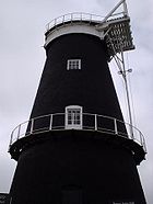
Besides the pub, the main focus is Berney Arms combined Mill and Windpump
Berney Arms Windmill
Berney Arms Windmill is located alongside the River Yare at the south-westerly end of Breydon Water.The windmill is in an isolated spot. The best approach for the visitor is by river or via the nearby railway station at Berney Arms...
. This is the tallest windmill
Windmill
A windmill is a machine which converts the energy of wind into rotational energy by means of vanes called sails or blades. Originally windmills were developed for milling grain for food production. In the course of history the windmill was adapted to many other industrial uses. An important...
in Norfolk, a Scheduled Ancient Monument
Scheduled Ancient Monument
In the United Kingdom, a scheduled monument is a 'nationally important' archaeological site or historic building, given protection against unauthorized change. The various pieces of legislation used for legally protecting heritage assets from damage and destruction are grouped under the term...
and is in the care of English Heritage
English Heritage
English Heritage . is an executive non-departmental public body of the British Government sponsored by the Department for Culture, Media and Sport...
. The mill is 21m tall, and the span of the sails is about the same. It has seven floors. It was built around 1870 by the millwright
Millwright
A millwright is a craftsman or tradesman engaged with the construction and maintenance of machinery.Early millwrights were specialist carpenters who erected machines used in agriculture, food processing and processing lumber and paper...
firm of Stolworthy. At first, it was used to grind cement
Cement
In the most general sense of the word, a cement is a binder, a substance that sets and hardens independently, and can bind other materials together. The word "cement" traces to the Romans, who used the term opus caementicium to describe masonry resembling modern concrete that was made from crushed...
clinker
Clinker
Clinker may refer to:* Clinker , construction method for wooden boats* Clinker , waste from industrial processes* Clinker , a kilned then quenched cement product* Clinker brick, rough dark coloured bricks...
. Later it was also used as a windpump
Windpump
A windpump is a windmill used for pumping water, either as a source of fresh water from wells, or for draining low-lying areas of land. Once a common fixture on farms in semi-arid areas, windpumps are still used today where electric power is not available or too expensive.-History:Windmills were...
to drain the marshland. The large scoop wheel is evidence of that use. The windpump was in use until 1951, and is now operated as a tourist attraction. On 24 May 2007 the restored sails of the mill were put back in place after nearly seven years.
Berney Marshes is a nature reserve
Nature reserve
A nature reserve is a protected area of importance for wildlife, flora, fauna or features of geological or other special interest, which is reserved and managed for conservation and to provide special opportunities for study or research...
in the care of the Royal Society for the Protection of Birds
Royal Society for the Protection of Birds
Bird Notes and News was first published in April 1903.The title changed to 'Bird Notes' in 1947. In the 1950s, there were four copies per year . Each volume covered two years, spread over three calendar years...
(RSPB), and part of the Halvergate Marshes
Halvergate Marshes
The Halvergate Marshes are marshes situated south of the River Bure on the Norfolk Broads in Norfolk, England, United Kingdom.Halvergate Marshes were an estuary in Roman times. Around 400 years ago the land was drained and converted to grazing marsh...
. The RSPB uses Ashtree Farm, the only other significant building remaining in the settlement, as its local headquarters.
Berney Arms Reach is the name for the part of the River Yare as it enters Breydon Water.
See also
- Berney Arms railway stationBerney Arms railway stationBerney Arms railway station is a halt serving the remote settlement of Berney Arms in the Halvergate Marshes, in the English county of Norfolk.The station, which is from the nearest road, is the most remote station in Norfolk...
- Berney Arms WindmillBerney Arms WindmillBerney Arms Windmill is located alongside the River Yare at the south-westerly end of Breydon Water.The windmill is in an isolated spot. The best approach for the visitor is by river or via the nearby railway station at Berney Arms...
- List of places in Norfolk