
Bernardo O'Higgins National Park
Encyclopedia
Bernardo O'Higgins National Park is the largest of the protected area
s in Chile
, covering an area of 35259 sqkm in both the Aisén and Magallanes and Antártica Chilena regions. The park is named after General Bernardo O'Higgins
, first head of state of the Republic of Chile. Los Glaciares National Park
(Argentina
) and Torres del Paine National Park
are its neighbours to the east, Laguna San Rafael National Park
is located to the north, the Alacalufes National Reserve
to the southwest and the Katalalixar National Reserve
to the northwest.
people.
In 1830 the then Captain Phillip Parker King on board H.M.S. Beagle visited the Eyre Fjord.
In June 2007 it was announced that between March and May 2007 all the water within a glacial lake located within the park had disappeared, leaving behind a 100-foot-deep crater. Only some blocks of ice, previously floating on the lake, remained behind on the crater floor. In July 2007 scientists were able to draw the preliminary conclusion that the disappearance occurred as a result of climate change.
(between the Baker Channel
and the northern part of the Fjord of the Mountains
. The Central-East Area of the Park is subject to a territorial dispute between Chile and Argentina. The highest summit is the Lautaro
volcano at 3607 m (11,834 ft). Other summits include the Mount Fitz Roy
, the Cerro Torre
and the Cerro Riso Patrón. The elevations are lower in the southern part of the park, but the scenery is still spectacular. The highlight of this zone is the Mount Balmaceda at 2035 m (6,677 ft), beautified by the glaciers Balmaceda and Serrano.
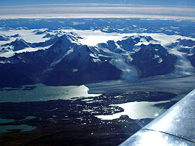
There are no large rivers on the park coast, but the narrow fjords penetrate deeply into the mountains and bring away the drainage of their ice-capped, storm-swept elevations.
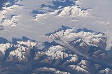
 The park includes a great part of the Southern Patagonian Ice Field
. One of its main attractions is the glacier Pío XI
, from which enormous ice blocks periodically spall. The Pío XI glacier is the largest glacier of the South hemisphere outside of Antarctica, covering an area of 1265 sqkm, advancing over the past 50 years by more than 10 km (6 mi); one of its tongues measures approximately 6 km (4 mi). The ice face of the glacier is approximately 75 m (246 ft) in height (about 30 floors of a conventional building) and the falling ice generates waves exceeding 10 m (33 ft) in height; significant enough to rock larger vessels. Other outlet glaciers are Chico, O'Higgins
, Jorge Montt
, Bernardo
, Témpano, Occidental, Greve, Penguin and Amalia
.
ecoregion.
The forests are made up of several trees species, including Nothofagus betuloides
, Nothofagus pumilio, Nothofagus antarctica
and Drimys winteri
.
The park is one of the last refuges for the Chilean Huemul. In this also can be found species such as Andean Condor
, Marine Otter
and Cormorant
.
and the glacier Pío XI are the most visited areas of the park. The main gateways for visitors to the park are Puerto Natales
, Villa O'Higgins
, Caleta Tortel
and Puerto Edén. Sea kayak
ing is a popular activity in the park.
Protected area
Protected areas are locations which receive protection because of their recognised natural, ecological and/or cultural values. There are several kinds of protected areas, which vary by level of protection depending on the enabling laws of each country or the regulations of the international...
s in Chile
Chile
Chile ,officially the Republic of Chile , is a country in South America occupying a long, narrow coastal strip between the Andes mountains to the east and the Pacific Ocean to the west. It borders Peru to the north, Bolivia to the northeast, Argentina to the east, and the Drake Passage in the far...
, covering an area of 35259 sqkm in both the Aisén and Magallanes and Antártica Chilena regions. The park is named after General Bernardo O'Higgins
Bernardo O'Higgins
Bernardo O'Higgins Riquelme was a Chilean independence leader who, together with José de San Martín, freed Chile from Spanish rule in the Chilean War of Independence. Although he was the second Supreme Director of Chile , he is considered one of Chile's founding fathers, as he was the first holder...
, first head of state of the Republic of Chile. Los Glaciares National Park
Los Glaciares National Park
Parque Nacional Los Glaciares is a national park in the Santa Cruz Province, in Argentine Patagonia. It comprises an area of 4459 km². In 1981 it was declared a World Heritage Site by UNESCO....
(Argentina
Argentina
Argentina , officially the Argentine Republic , is the second largest country in South America by land area, after Brazil. It is constituted as a federation of 23 provinces and an autonomous city, Buenos Aires...
) and Torres del Paine National Park
Torres del Paine National Park
Torres del Paine National Park is a national park encompassing mountains, a glacier, a lake, and river-rich areas in southern Chilean Patagonia. The Cordillera del Paine is the centerpiece of the park. It lies in a transition area between the Magellanic subpolar forests and the Patagonian Steppes...
are its neighbours to the east, Laguna San Rafael National Park
Laguna San Rafael National Park
Laguna San Rafael National Park is a park located on the Pacific coast of southern Chile. The park is named for the San Rafael Lagoon formed by the retreat of the San Rafael Glacier. Created in 1959, it covers an area of and includes the Northern Patagonian Ice Field...
is located to the north, the Alacalufes National Reserve
Alacalufes National Reserve
Alacalufes National Reserve is located between Canal Concepción and Strait of Magellan. It is composed of western archipelagos, its landscape is filled with low mountain-like islands and islets, lots of channels and fjords...
to the southwest and the Katalalixar National Reserve
Katalalixar National Reserve
Katalalixar National Reserve is a natural reserve located in an archipelago between Southern Patagonian Ice Field, and Northern Patagonian Ice Field in Aisén Region of Chile. The reserve was created in 1983 and has no infrastructure. It covers an area of within the Magellanic subpolar forests...
to the northwest.
History
The earliest occupants of the area were the AlacalufAlacaluf
The Alacaluf are a South American people living in Chile on the Strait of Magellan , Chile. Their traditional language is known as Kawésqar.- Economy :They were a nomadic sea-faring people until the twentieth century...
people.
In 1830 the then Captain Phillip Parker King on board H.M.S. Beagle visited the Eyre Fjord.
In June 2007 it was announced that between March and May 2007 all the water within a glacial lake located within the park had disappeared, leaving behind a 100-foot-deep crater. Only some blocks of ice, previously floating on the lake, remained behind on the crater floor. In July 2007 scientists were able to draw the preliminary conclusion that the disappearance occurred as a result of climate change.
Geography
The park is located approximately between 48° and 51° 38' South LatitudeLatitude
In geography, the latitude of a location on the Earth is the angular distance of that location south or north of the Equator. The latitude is an angle, and is usually measured in degrees . The equator has a latitude of 0°, the North pole has a latitude of 90° north , and the South pole has a...
(between the Baker Channel
Baker Channel
Baker Channel, also known as Calen Inlet, is a channel of Chile located in the Aisén Region. The Baker River discharges into Martinez Inlet, the northern part of this large estuary. It penetrates the mainland about 75 mi and opens into Tarn Bay at the south-east corner of the Gulf of Penas...
and the northern part of the Fjord of the Mountains
Fjord of the Mountains
Fjord of the Mountains, also known as "Channel of the Mountains", is located to the west of Puerto Natales, Chile and inside the boundaries of the Alacalufes National Reserve. It stretches 66 km from north to south and is flanked by two mountain ranges, the Cordillera Sarmiento to the west and the...
. The Central-East Area of the Park is subject to a territorial dispute between Chile and Argentina. The highest summit is the Lautaro
Lautaro (volcano)
Lautaro Volcano is an active ice-covered stratovolcano located in Chilean Patagonia, in the northern part of the Southern Patagonian Ice Field. Its summit rises more than above the average surface of the ice cap plateau. It is the tallest mountain in Bernardo O'Higgins National Park and in its...
volcano at 3607 m (11,834 ft). Other summits include the Mount Fitz Roy
Cerro Chaltén
Monte Fitz Roy is a mountain located near El Chaltén village, in the Southern Patagonian Ice Field in Patagonia, on the border between Argentina and Chile...
, the Cerro Torre
Cerro Torre
Cerro Torre is one of the mountains of the Southern Patagonian Ice Field in South America. It is located in a region which is disputed between Argentina and Chile, west of Cerro Chalten . The peak is the highest in a four mountain chain: the other peaks are Torre Egger , Punta Herron, and Cerro...
and the Cerro Riso Patrón. The elevations are lower in the southern part of the park, but the scenery is still spectacular. The highlight of this zone is the Mount Balmaceda at 2035 m (6,677 ft), beautified by the glaciers Balmaceda and Serrano.
There are no large rivers on the park coast, but the narrow fjords penetrate deeply into the mountains and bring away the drainage of their ice-capped, storm-swept elevations.
Glaciers
Southern Patagonian Ice Field
The Southern Patagonian Ice Field , located at the Southern Patagonic Andes between Argentina and Chile, is the second largest contiguous extrapolar extent of ice in the world...
. One of its main attractions is the glacier Pío XI
Brüggen Glacier
Brüggen Glacier, also known as Pío XI Glacier, is in southern Chile and is the largest western outflow from the Southern Patagonian Ice Field. Now about in length, it is the longest glacier in the southern hemisphere outside of Antarctica...
, from which enormous ice blocks periodically spall. The Pío XI glacier is the largest glacier of the South hemisphere outside of Antarctica, covering an area of 1265 sqkm, advancing over the past 50 years by more than 10 km (6 mi); one of its tongues measures approximately 6 km (4 mi). The ice face of the glacier is approximately 75 m (246 ft) in height (about 30 floors of a conventional building) and the falling ice generates waves exceeding 10 m (33 ft) in height; significant enough to rock larger vessels. Other outlet glaciers are Chico, O'Higgins
O'Higgins Glacier
O'Higgins Glacier is a glacier located in Bernardo O'Higgins National Park, Chile. It is one of the principal glaciers of the Southern Patagonian Ice Field. The summit of the active Lautaro volcano is the top of the accumulation zone of the glacier. The bulk of the glacier is part of the icefield...
, Jorge Montt
Jorge Montt Glacier
Jorge Montt Glacier is a tidewater glacier located in the Aisén Region of Chile, south of the town of Caleta Tortel. It lies at the north end of the Southern Patagonian Ice Field, within Bernardo O'Higgins National Park. The mouth of Pascua River is located in the vicinity of the glacier calving...
, Bernardo
Bernardo Glacier
Bernardo Glacier is one of the largest glaciers in the Southern Patagonian Ice Field. It is located northeast of Témpano Glacier, within Bernardo O'Higgins National Park. The glacier flows westward Bernardo Fjord....
, Témpano, Occidental, Greve, Penguin and Amalia
Amalia Glacier
Amalia Glacier, also known as Skua Glacier, is a tidewater glacier located in Bernardo O'Higgins National Park. It originates in the Southern Patagonian Ice Field and from 1945 to 1986 its terminus retreated , being, along with the receded of O'Higgins Glacier, the most drastic retreat of the...
.
Biology
The area of the park corresponds to the Magellanic subpolar forestsMagellanic subpolar forests
The Magellanic subpolar forests are a terrestrial ecoregion of southernmost South America, covering parts of southern Chile and Argentina, and is part of the Neotropic ecozone...
ecoregion.
The forests are made up of several trees species, including Nothofagus betuloides
Nothofagus betuloides
Nothofagus betuloides, the Magellan's beech and is sometimes known by the common name guindo, is native to southern Patagonia.In 1769 Sir Joseph Banks collected a specimen of the tree in Tierra del Fuego during Captain Cook's first voyage....
, Nothofagus pumilio, Nothofagus antarctica
Nothofagus antarctica
Nothofagus antarctica , is a deciduous tree or shrub native to southern Chile and Argentina from about 36°S to Tierra del Fuego . The southernmost occurrence is on Hoste Island, making it the southernmost trees on earth...
and Drimys winteri
Drimys winteri
Drimys winteri , or Canelo, is a slender tree, growing up to 20 m tall. It is native to the Magellanic and Valdivian temperate rain forests of Chile and Argentina, where it is a dominant tree in the coastal evergreen forests. It is found below 1200 meters between latitude 32° south and Cape...
.
The park is one of the last refuges for the Chilean Huemul. In this also can be found species such as Andean Condor
Andean Condor
The Andean Condor is a species of South American bird in the New World vulture family Cathartidae and is the only member of the genus Vultur...
, Marine Otter
Marine Otter
The marine otter, Lontra felina, is a rare and poorly-known South American mammal of the weasel family . The scientific name means "otter cat", and in Spanish the marine otter is also often referred to as : "marine cat"...
and Cormorant
Cormorant
The bird family Phalacrocoracidae is represented by some 40 species of cormorants and shags. Several different classifications of the family have been proposed recently, and the number of genera is disputed.- Names :...
.
Tourism
Because of its rugged geography and the remoteness of the area, the tourism in the park has been scarcely developed. It is only accessible by boat or helicopter. The glaciers located at the head of Última Esperanza SoundÚltima Esperanza Sound
Última Esperanza Sound is an inlet stretching from the mouth of Eberhard Fjord to the outskirts of Monte Balmaceda, within the Magallanes Basin. This inlet, known within Chile as Seno Última Esperanza, has the characteristics of a tidewater river and drains an extensive basin...
and the glacier Pío XI are the most visited areas of the park. The main gateways for visitors to the park are Puerto Natales
Puerto Natales
Puerto Natales is a city in Chilean Patagonia. Puerto Natales is the capital of both the commune of Natales and the province of Última Esperanza, , one of the four provinces that make up the Magallanes and Antartica Chilena Region in the southernmost part of Chile...
, Villa O'Higgins
Villa O'Higgins
Villa O'Higgins is a village in southern Chile, located in the Capitán Prat Province, in the south of Aisén Region. It is the capital of the O'Higgins commune and marks the end of the Carretera Austral. The village is named after Chilean independence hero Bernardo O'Higgins.-Facilities:The village...
, Caleta Tortel
Caleta Tortel
Caleta Tortel is a coastal village in Chile. It is the administrave center of the commune of Tortel and is located between the mouth of the Baker River and a small embayment of the Baker Channel. The surrounding geography is rugged, formed by a number of islands, fjords, channels and estuaries...
and Puerto Edén. Sea kayak
Sea kayak
A sea kayak or touring kayak is a kayak developed for the sport of paddling on open waters of lakes, bays, and the ocean. Sea kayaks are seaworthy small boats with a covered deck and the ability to incorporate a spraydeck...
ing is a popular activity in the park.
External links
- WCS in Chile's O'Higgins National Park
- Two sections of Turistel map, showing park boundaries: http://www.turistel.cl/v2/secciones/mapas/ruteros/aisen.htm, http://www.turistel.cl/v2/secciones/mapas/ruteros/magallanes.htm