
Ben Hai River
Encyclopedia
The Ben Hai River is a river in central Vietnam
which became an important landmark in the partition of the country into a northern
and a southern zone
along the 17th parallel
by the Geneva Accords
of 1954. The demilitarized zone (DMZ)
separating the two parts extended about 5 kilometres (3.1 mi) from either side of the river.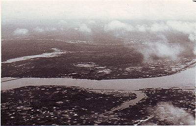 The Ben Hai River has a total length of about 100 kilometers; its source is located in the Annamite Mountains
along the border with Laos
and it flows into the South China Sea
at Cua Tung (Tung River mouth). In the mountains, the river is named "Rao Thanh". It flows from west to east just south of the 17th parallel and close to the northern border of Quang Tri Province
, in which it is located. At its widest point, the river is about 200 meters wide.
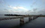
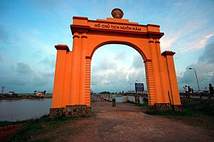 At the time of the partition, the principal north-south road (Highway 1) crossed the Ben Hai River over Hien Luong Bridge (also known as the "Peace Bridge"), a beam bridge
built from steel by the French in 1950. After the partition, the northern portion of the bridge was painted red and the southern portion yellow. The bridge was damaged by American bombardment during the Vietnam War
in 1967. After the Paris Peace Accords
, a modern bridge was built next to the old bridge.
Vietnam
Vietnam – sometimes spelled Viet Nam , officially the Socialist Republic of Vietnam – is the easternmost country on the Indochina Peninsula in Southeast Asia. It is bordered by China to the north, Laos to the northwest, Cambodia to the southwest, and the South China Sea –...
which became an important landmark in the partition of the country into a northern
North Vietnam
The Democratic Republic of Vietnam , was a communist state that ruled the northern half of Vietnam from 1954 until 1976 following the Geneva Conference and laid claim to all of Vietnam from 1945 to 1954 during the First Indochina War, during which they controlled pockets of territory throughout...
and a southern zone
South Vietnam
South Vietnam was a state which governed southern Vietnam until 1975. It received international recognition in 1950 as the "State of Vietnam" and later as the "Republic of Vietnam" . Its capital was Saigon...
along the 17th parallel
17th parallel north
The 17th parallel north is a circle of latitude that is 17 degrees north of the Earth's equatorial plane. It crosses Africa, Asia, the Indian Ocean, the Pacific Ocean, Central America, the Caribbean and the Atlantic Ocean....
by the Geneva Accords
Geneva Conference (1954)
The Geneva Conference was a conference which took place in Geneva, Switzerland, whose purpose was to attempt to find a way to unify Korea and discuss the possibility of restoring peace in Indochina...
of 1954. The demilitarized zone (DMZ)
Vietnamese Demilitarized Zone
The Vietnamese Demilitarized Zone was established as a dividing line between North and South Vietnam as a result of the First Indochina War.During the Second Indochina War , it became important as the battleground demarcation separating North Vietnamese territory from South Vietnamese territory.-...
separating the two parts extended about 5 kilometres (3.1 mi) from either side of the river.
Annamite Range
The Annamite Range or the Annamese Mountains is a mountain range of eastern Indochina, which extends approximately through Laos, Vietnam, and a small area in northeast Cambodia. It is known in Vietnamese as Dãy Trường Sơn, in Lao as Xai Phou Luang , and in French as the Chaîne Annamitique...
along the border with Laos
Laos
Laos Lao: ສາທາລະນະລັດ ປະຊາທິປະໄຕ ປະຊາຊົນລາວ Sathalanalat Paxathipatai Paxaxon Lao, officially the Lao People's Democratic Republic, is a landlocked country in Southeast Asia, bordered by Burma and China to the northwest, Vietnam to the east, Cambodia to the south and Thailand to the west...
and it flows into the South China Sea
South China Sea
The South China Sea is a marginal sea that is part of the Pacific Ocean, encompassing an area from the Singapore and Malacca Straits to the Strait of Taiwan of around...
at Cua Tung (Tung River mouth). In the mountains, the river is named "Rao Thanh". It flows from west to east just south of the 17th parallel and close to the northern border of Quang Tri Province
Quang Tri Province
Quảng Trị is a province on the North Central Coast of Vietnam, north of the former imperial capital of Huế.-Geography:Located in North Central Vietnam, Quang Tri Province is surrounded by Quang Binh Province on the north, Thua Thien-Hue Province on the south, Savannakhet Province of Laos on the...
, in which it is located. At its widest point, the river is about 200 meters wide.
Beam bridge
Beam bridges are the most simple of structural forms being supported by an abutment at each end of the deck. No moments are transferred through the support hence their structural type is known as simply supported....
built from steel by the French in 1950. After the partition, the northern portion of the bridge was painted red and the southern portion yellow. The bridge was damaged by American bombardment during the Vietnam War
Vietnam War
The Vietnam War was a Cold War-era military conflict that occurred in Vietnam, Laos, and Cambodia from 1 November 1955 to the fall of Saigon on 30 April 1975. This war followed the First Indochina War and was fought between North Vietnam, supported by its communist allies, and the government of...
in 1967. After the Paris Peace Accords
Paris Peace Accords
The Paris Peace Accords of 1973 intended to establish peace in Vietnam and an end to the Vietnam War, ended direct U.S. military involvement, and temporarily stopped the fighting between North and South Vietnam...
, a modern bridge was built next to the old bridge.