

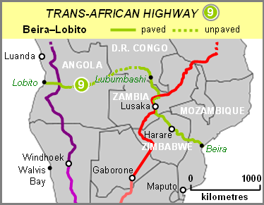
Beira-Lobito Highway
Encyclopedia
Beira, Mozambique
Beira is the second largest city in Mozambique. It lies in the central region of the country in Sofala Province, where the Pungue River meets the Indian Ocean. Beira had a population of 412,588 in 1997, which grew to an estimated 546,000 in 2006...
–Lobito
Lobito
Lobito is a town and municipality in Benguela Province in Angola.It dates from 1905 and owes its existence to the bay of the same name having been chosen as the sea terminus of the Benguela railway to the far interior, passing through Luau to Katanga in the Democratic Republic of the Congo. The...
Highway is Trans-African Highway 9 in the transcontinental
Transcontinental
The fourth largest print media group in Canada, with more than 3,000 employees and annual revenues of $608 million in 2010, TC. Transcontinental reaches, through its multiplatform offering, over 18 million consumers across Canada...
road
Road
A road is a thoroughfare, route, or way on land between two places, which typically has been paved or otherwise improved to allow travel by some conveyance, including a horse, cart, or motor vehicle. Roads consist of one, or sometimes two, roadways each with one or more lanes and also any...
network being developed by the United Nations Economic Commission for Africa
United Nations Economic Commission for Africa
The United Nations Economic Commission for Africa was established in 1958 by the United Nations Economic and Social Council to encourage economic cooperation among its member states following a recommendation of the United Nations General Assembly.It is one of five regional commissions.The ECA...
(UNECA), the African Development Bank
African Development Bank
The African Development Bank Group is a development bank established in 1964 with the intention of promoting economic and social development in Africa...
(ADB), and the African Union
African Union
The African Union is a union consisting of 54 African states. The only all-African state not in the AU is Morocco. Established on 9 July 2002, the AU was formed as a successor to the Organisation of African Unity...
. The route has a length of 3523 km crossing Angola
Angola
Angola, officially the Republic of Angola , is a country in south-central Africa bordered by Namibia on the south, the Democratic Republic of the Congo on the north, and Zambia on the east; its west coast is on the Atlantic Ocean with Luanda as its capital city...
, the most southerly part of the Democratic Republic of the Congo
Democratic Republic of the Congo
The Democratic Republic of the Congo is a state located in Central Africa. It is the second largest country in Africa by area and the eleventh largest in the world...
, Zambia
Zambia
Zambia , officially the Republic of Zambia, is a landlocked country in Southern Africa. The neighbouring countries are the Democratic Republic of the Congo to the north, Tanzania to the north-east, Malawi to the east, Mozambique, Zimbabwe, Botswana and Namibia to the south, and Angola to the west....
, Zimbabwe
Zimbabwe
Zimbabwe is a landlocked country located in the southern part of the African continent, between the Zambezi and Limpopo rivers. It is bordered by South Africa to the south, Botswana to the southwest, Zambia and a tip of Namibia to the northwest and Mozambique to the east. Zimbabwe has three...
, and central Mozambique
Mozambique
Mozambique, officially the Republic of Mozambique , is a country in southeastern Africa bordered by the Indian Ocean to the east, Tanzania to the north, Malawi and Zambia to the northwest, Zimbabwe to the west and Swaziland and South Africa to the southwest...
.
It is substantially complete in its south-eastern half where it uses paved national roads of Zambia, Zimbabwe and Mozambique, but the western half through most of Angola and DR Congo consists of earth tracks or formerly paved roads requiring reconstruction.
The route links mining areas of DR Congo, Zambia and Zimbabwe and agricultural production areas of Angola, Zambia and Zimbabwe to the Atlantic port of Lobito and Indian Ocean
Indian Ocean
The Indian Ocean is the third largest of the world's oceanic divisions, covering approximately 20% of the water on the Earth's surface. It is bounded on the north by the Indian Subcontinent and Arabian Peninsula ; on the west by eastern Africa; on the east by Indochina, the Sunda Islands, and...
port of Beira. Civil wars in Angola, DR Congo, Zimbabwe and Mozambique have affected development of the highway in the past, most recently in DR Congo and Angola, both still in a rebuilding phase.
The route is also served by a rail link running parallel to it for much of its length except between Kafue
Kafue
Kafue is a town in the Lusaka Province of Zambia on the north bank of the Kafue River, after which it is named. It is the southern gateway to the central Zambian plateau on which Lusaka and the mining towns of Kabwe and the Copperbelt are located.- Site :...
and Harare
Harare
Harare before 1982 known as Salisbury) is the largest city and capital of Zimbabwe. It has an estimated population of 1,600,000, with 2,800,000 in its metropolitan area . Administratively, Harare is an independent city equivalent to a province. It is Zimbabwe's largest city and its...
, though it too has been damaged in wars and its western half, the Benguela Railway, does not currently operate.
Between Kapiri Mposhi
Kapiri Mposhi
Kapiri Mposhi is a small town in Zambia. Located north of Lusaka, it stands on the Great North Road and is significant for the railway connection between Zambia Railways line from Kitwe to Lusaka and Livingstone and western terminal of the Tanzania-Zambia Railway Authority from Dar-es-Salaam since...
and Kafue
Kafue
Kafue is a town in the Lusaka Province of Zambia on the north bank of the Kafue River, after which it is named. It is the southern gateway to the central Zambian plateau on which Lusaka and the mining towns of Kabwe and the Copperbelt are located.- Site :...
in Zambia the highway shares the route with the Cairo-Cape Town Highway
Cairo-Cape Town Highway
The Cairo-Cape Town Highway is Trans-African Highway 4 in the transcontinental road network being developed by the United Nations Economic Commission for Africa , the African Development Bank , and the African Union...
.
When complete the highway will be the southernmost of the Trans-African network's east-west crossings of the continent. However regional highways developed by the Southern African Development Community
Southern African Development Community
The Southern African Development Community is an inter-governmental organization headquartered in Gaborone, Botswana. Its goal is to further socio-economic cooperation and integration as well as political and security cooperation among 15 southern African states...
(SADC) already offer well-functioning and fully paved alternative routes, particularly the Trans–Caprivi Highway from the port of Walvis Bay
Walvis Bay
Walvis Bay , is a city in Namibia and the name of the bay on which it lies...
in Namibia
Namibia
Namibia, officially the Republic of Namibia , is a country in southern Africa whose western border is the Atlantic Ocean. It shares land borders with Angola and Zambia to the north, Botswana to the east and South Africa to the south and east. It gained independence from South Africa on 21 March...
, and the more southerly link via Botswana
Botswana
Botswana, officially the Republic of Botswana , is a landlocked country located in Southern Africa. The citizens are referred to as "Batswana" . Formerly the British protectorate of Bechuanaland, Botswana adopted its new name after becoming independent within the Commonwealth on 30 September 1966...
and South Africa
South Africa
The Republic of South Africa is a country in southern Africa. Located at the southern tip of Africa, it is divided into nine provinces, with of coastline on the Atlantic and Indian oceans...
to the port of Maputo
Maputo
Maputo, also known as Lourenço Marques, is the capital and largest city of Mozambique. It is known as the City of Acacias in reference to acacia trees commonly found along its avenues and the Pearl of the Indian Ocean. It was famous for the inscription "This is Portugal" on the walkway of its...
in southern Mozambique.
Furthermore Zambia
Zambia
Zambia , officially the Republic of Zambia, is a landlocked country in Southern Africa. The neighbouring countries are the Democratic Republic of the Congo to the north, Tanzania to the north-east, Malawi to the east, Mozambique, Zimbabwe, Botswana and Namibia to the south, and Angola to the west....
has a higher priority to complete the Barotse Floodplain causeway (the Mongu–Kalabo road) extending its Great West Road
Great West Road, Zambia
The Great West Road of Zambia runs 610 km from the capital, Lusaka, to Mongu, capital of the Western Province. It connects that province to the rest of the country, as well as being one of two routes to the south-west extremity of North-Western Province...
and has proposed to the Angolan government that it continue into that country to link up with its road network. Secondly, DR Congo has been offered a loan and construction assistance by China
China
Chinese civilization may refer to:* China for more general discussion of the country.* Chinese culture* Greater China, the transnational community of ethnic Chinese.* History of China* Sinosphere, the area historically affected by Chinese culture...
to develop a railway from Lubumbashi
Lubumbashi
Lubumbashi is the second largest city in the Democratic Republic of the Congo, second only to the nation's capital Kinshasa, and the hub of the southeastern part of the country. The copper-mining city serves as the capital of the relatively prosperous Katanga Province, lying near the Zambian border...
to its port of Matadi
Matadi
Matadi is the chief sea port of the Democratic Republic of the Congo and the capital of the Bas-Congo province. It has a population of 245,862 . Matadi is situated on the left bank of the Congo River from the mouth and below the last navigable point before rapids make the river impassable for a...
as its main trade route. Trans-African Highway 9 might then be relegated to a back-burner by Southern African regional developments.