
Beinn a' Chuallaich
Encyclopedia
Beinn a’ Chuallaich is a Scottish
hill located at co-ordinates 56.7293°N 4.1513°W, four km NE of the village of Kinloch Rannoch
in the Perth and Kinross
council area. It is part of the high ground between Strath Tummel and Glen Errochty.
which lies seven km to the SE across Dunalastair Water
and dominates Strath Tummel. However Beinn a' Chuallaich is well seen from the head of Glen Errochty where it shows its long NE ridge and its craggy eastern corrie
. The hill reaches a height of 892 metres (2926 feet) and qualifies as a Corbett
and a Marilyn
.
as “Hill of the Herding” and this refers to the fact that it lies on the route of one of the main north-south ancient drovers' roads of Scotland, the area around the mountain was used as a gathering point for the cattle. The western corrie of the hill could well have been the collecting point as it is a huge gentle bowl which is ideal for summer grazing and the concealing of cattle. James Stobie’s map of 1770 refers to the hill as Ben Chualach, Charles Knight
’s Penny Cyclopaedia
of the 1840s also uses this name and the hill seems to have been designated as Beinn a’ Chuallaich by Victorian
cartographers in the second half of the 19th century.
. The top of Meall nan Eun is marked by a ring of stones and gives a fine view of Loch Errochty which is not visible from the main summit. Loch
na Caillich stands on this NE ridge at a height of around 700 metres and is a well known gathering point for deer
with Charles Plumb describing it as a place “where the deer love to wallow”. Coire Odhar on the eastern side of the hill is ringed by cliffs which fall from the summit, the corrie itself contains some very large detached boulders. The western corrie, known as Coire Labhrainn is drained by the Allt Mòr which is a fine sight after heavy rain as it roars through the woodland above Kinloch Rannoch and through the village to join the River Tummel. All drainage from the mountain joins the River Tay
eventually either going by Glen Errochty or Strath Tummel. Some of the streams on the eastern side of the hill have been diverted into the Errochty catchwater
as part of the Tummel hydro-electric power scheme
.
 The three southern ridges are quite steep as they drop away to the valley of the River Tummel. One goes initially west and then south taking in the craggy and rocky slopes of the outlying top of Càrn Fiaclach. Another ridge goes just east of south descending to Drumglas on the shores of Dunalistair Water and has the crags of Creag Buidhe on its lower slopes. The third of the ridges on the south side of the mountain goes just west of south and is the most interesting of the three as it ends in a steep and spectacular crag which drops to the B846 road just east of Kinloch Rannoch. The crag is known as Craig Varr and is an example of a truncated spur formed in the Earth’s last glacial period about 10,000 years ago when the huge glacier flowing east from Rannoch Moor
sliced through the ridge descending to the valley and left steep south facing cliffs.
crags contain around 30 routes from 30 to 50 metres in length, varying in grade from Very Difficult to Very Severe. The crags are south facing, a fact which adds to their popularity, being quick drying and catching plenty of sunshine.
and Drumglas. From Kinloch Rannoch the route goes up the Allt Mòr, passing a fine waterfall before going steep up to the summit ridge. The route from Drumglas is the most direct and utilises the SE ridge. An approach from the east starts from the B847 road at grid reference and goes past a bothy
and a deer fence before going steeply up to climb Coire Odhar and reach the summit.
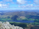
Beinn a’ Chuallaich is a fine viewpoint, having a topographic prominence
of 527 metres, it is the highest point for some distance with Schiehallion, over seven km to the SE being the only hill to interrupt the distant view. There is a fine full length view of Loch Rannoch
and the Ben Alder
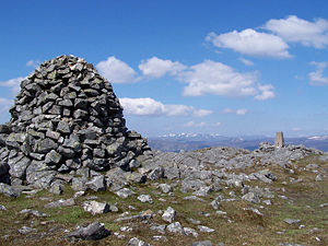
massif to the NW. The highest point of the hill is marked by an Ordnance Survey
trig point
but the highlight of the summit is the three metre high cairn built from quartzite
boulders which stands 20 metres SE of the trig point.
Scotland
Scotland is a country that is part of the United Kingdom. Occupying the northern third of the island of Great Britain, it shares a border with England to the south and is bounded by the North Sea to the east, the Atlantic Ocean to the north and west, and the North Channel and Irish Sea to the...
hill located at co-ordinates 56.7293°N 4.1513°W, four km NE of the village of Kinloch Rannoch
Kinloch Rannoch
Kinloch Rannoch is a village in Perth and Kinross, Scotland, at the eastern end of Loch Rannoch, 18 miles west of Pitlochry, on the banks of the River Tummel.The village is a tourist and outdoor pursuits centre...
in the Perth and Kinross
Perth and Kinross
Perth and Kinross is one of 32 council areas in Scotland, and a Lieutenancy Area. It borders onto the Aberdeenshire, Angus, Dundee City, Fife, Clackmannanshire, Stirling, Argyll and Bute and Highland council areas. Perth is the administrative centre...
council area. It is part of the high ground between Strath Tummel and Glen Errochty.
Overview
Beinn a’ Chuallaich is a sizeable and extensive hill which can seem quite inconspicuous when viewed from certain places, especially from the south. This is mainly because of the close proximity of the more eye catching and higher SchiehallionSchiehallion
Schiehallion is a prominent mountain in Perth and Kinross, Scotland. Schiehallion has a rich botanical life, interesting archaeology, and a unique place in scientific history for an 18th-century experiment in 'weighing the world'...
which lies seven km to the SE across Dunalastair Water
Dunalastair Water
Dunalastair Water is an entirely man made reservoir in Scotland which lies between Loch Rannoch and Loch Tummel in Strath Tummel in Perth and Kinross council area...
and dominates Strath Tummel. However Beinn a' Chuallaich is well seen from the head of Glen Errochty where it shows its long NE ridge and its craggy eastern corrie
Cirque
Cirque may refer to:* Cirque, a geological formation* Makhtesh, an erosional landform found in the Negev desert of Israel and Sinai of Egypt*Cirque , an album by Biosphere* Cirque Corporation, a company that makes touchpads...
. The hill reaches a height of 892 metres (2926 feet) and qualifies as a Corbett
Hill lists in the British Isles
The mountains and hills of Great Britain, and to a lesser extent Ireland, are the subject of a considerable number of lists that categorise them by height, topographic prominence, or other criteria. They are commonly used as a basis for peak bagging, whereby hillwalkers attempt to reach all the...
and a Marilyn
Marilyn (hill)
A Marilyn is a mountain or hill in the United Kingdom, Republic of Ireland or Isle of Man with a relative height of at least 150 metres , regardless of absolute height or other merit...
.
Etymology
The hill’s name translates from the Scottish Gaelic languageScottish Gaelic language
Scottish Gaelic is a Celtic language native to Scotland. A member of the Goidelic branch of the Celtic languages, Scottish Gaelic, like Modern Irish and Manx, developed out of Middle Irish, and thus descends ultimately from Primitive Irish....
as “Hill of the Herding” and this refers to the fact that it lies on the route of one of the main north-south ancient drovers' roads of Scotland, the area around the mountain was used as a gathering point for the cattle. The western corrie of the hill could well have been the collecting point as it is a huge gentle bowl which is ideal for summer grazing and the concealing of cattle. James Stobie’s map of 1770 refers to the hill as Ben Chualach, Charles Knight
Charles Knight (publisher)
Charles Knight was an English publisher and author.-Early life:The son of a bookseller and printer at Windsor, he was apprenticed to his father...
’s Penny Cyclopaedia
Penny Cyclopaedia
The Penny Cyclopædia of the Society for the Diffusion of Useful Knowledge was a multi-volume encyclopedia edited by George Long and published by Charles Knight alongside the Penny Magazine. The volumes were published from 1833 to 1843.-External links:...
of the 1840s also uses this name and the hill seems to have been designated as Beinn a’ Chuallaich by Victorian
Victorian era
The Victorian era of British history was the period of Queen Victoria's reign from 20 June 1837 until her death on 22 January 1901. It was a long period of peace, prosperity, refined sensibilities and national self-confidence...
cartographers in the second half of the 19th century.
Geography
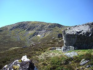
Beinn a’ Chuallaich’s large bulk dominates the village of Kinloch Rannoch and contains several long ridges and two significant corries. The longest of the ridges goes north and then NE taking in the subsidiary top of Meall nan Eun (852 metres) before broadening and descending NE to the shores of Loch ErrochtyLoch Errochty
Loch Errochty is a man made freshwater loch in the Scottish Highlands it is situated within the Perth and Kinross council area.- Overview :...
. The top of Meall nan Eun is marked by a ring of stones and gives a fine view of Loch Errochty which is not visible from the main summit. Loch
Loch
Loch is the Irish and Scottish Gaelic word for a lake or a sea inlet. It has been anglicised as lough, although this is pronounced the same way as loch. Some lochs could also be called a firth, fjord, estuary, strait or bay...
na Caillich stands on this NE ridge at a height of around 700 metres and is a well known gathering point for deer
Deer
Deer are the ruminant mammals forming the family Cervidae. Species in the Cervidae family include white-tailed deer, elk, moose, red deer, reindeer, fallow deer, roe deer and chital. Male deer of all species and female reindeer grow and shed new antlers each year...
with Charles Plumb describing it as a place “where the deer love to wallow”. Coire Odhar on the eastern side of the hill is ringed by cliffs which fall from the summit, the corrie itself contains some very large detached boulders. The western corrie, known as Coire Labhrainn is drained by the Allt Mòr which is a fine sight after heavy rain as it roars through the woodland above Kinloch Rannoch and through the village to join the River Tummel. All drainage from the mountain joins the River Tay
River Tay
The River Tay is the longest river in Scotland and the seventh-longest in the United Kingdom. The Tay originates in western Scotland on the slopes of Ben Lui , then flows easterly across the Highlands, through Loch Dochhart, Loch Lubhair and Loch Tay, then continues east through Strathtay , in...
eventually either going by Glen Errochty or Strath Tummel. Some of the streams on the eastern side of the hill have been diverted into the Errochty catchwater
Catchwater
A catchwater is a large-scale man-made device for catching surface runoff from hills and channelling it to reservoirs for later usage as a part of the public water supply....
as part of the Tummel hydro-electric power scheme
Tummel hydro-electric power scheme
The Tummel hydro-electric power scheme for the generation of hydro-electric power is located in the Grampian Mountains, between Loch Ericht, Loch Rannoch and Loch Tummel, in Perth and Kinross, Scotland.-References: – PDF file-External links:*...
.
Rannoch Moor
Rannoch Moor is a large expanse of around 50 square miles of boggy moorland to the west of Loch Rannoch, in Perth and Kinross and Lochaber, Highland, partly northern Argyll and Bute, Scotland...
sliced through the ridge descending to the valley and left steep south facing cliffs.
Rock climbing
The crags of Craig Varr are a popular venue for rock climbers being close to the road and parking spots. The 100 metre high schistSchist
The schists constitute a group of medium-grade metamorphic rocks, chiefly notable for the preponderance of lamellar minerals such as micas, chlorite, talc, hornblende, graphite, and others. Quartz often occurs in drawn-out grains to such an extent that a particular form called quartz schist is...
crags contain around 30 routes from 30 to 50 metres in length, varying in grade from Very Difficult to Very Severe. The crags are south facing, a fact which adds to their popularity, being quick drying and catching plenty of sunshine.
Ascents and summit
Beinn a’ Chuallaich is usually ascended from the south or the east. From the south there are routes from Kinloch RannochKinloch Rannoch
Kinloch Rannoch is a village in Perth and Kinross, Scotland, at the eastern end of Loch Rannoch, 18 miles west of Pitlochry, on the banks of the River Tummel.The village is a tourist and outdoor pursuits centre...
and Drumglas. From Kinloch Rannoch the route goes up the Allt Mòr, passing a fine waterfall before going steep up to the summit ridge. The route from Drumglas is the most direct and utilises the SE ridge. An approach from the east starts from the B847 road at grid reference and goes past a bothy
Bothy
A bothy is a basic shelter, usually left unlocked and available for anyone to use free of charge. It was also a term for basic accommodation, usually for gardeners or other workers on an estate. Bothies are to be found in remote, mountainous areas of Scotland, northern England, Ireland, and Wales....
and a deer fence before going steeply up to climb Coire Odhar and reach the summit.
Beinn a’ Chuallaich is a fine viewpoint, having a topographic prominence
Topographic prominence
In topography, prominence, also known as autonomous height, relative height, shoulder drop , or prime factor , categorizes the height of the mountain's or hill's summit by the elevation between it and the lowest contour line encircling it and no higher summit...
of 527 metres, it is the highest point for some distance with Schiehallion, over seven km to the SE being the only hill to interrupt the distant view. There is a fine full length view of Loch Rannoch
Loch Rannoch
Loch Rannoch is a large body of fresh water in Perth and Kinross, Scotland.The loch is over long in a west-east direction with an average width of about . The River Tummel begins at its eastern end. The Tay Forest Park lies along its southern shore...
and the Ben Alder
Ben Alder
Ben Alder is the highest mountain in the remote area of the Scottish Highlands between Loch Ericht and Glen Spean. The vast summit plateau is home of one of Britain's highest bodies of standing water, Lochan a' Garbh Coire. It is the 25th highest Munro, and due to its remote location, one of the...
massif to the NW. The highest point of the hill is marked by an Ordnance Survey
Ordnance Survey
Ordnance Survey , an executive agency and non-ministerial government department of the Government of the United Kingdom, is the national mapping agency for Great Britain, producing maps of Great Britain , and one of the world's largest producers of maps.The name reflects its creation together with...
trig point
Trig point
A triangulation station, also known as a triangulation pillar, trigonometrical station, trigonometrical point, trig station, trig beacon or trig point, and sometimes informally as a trig, is a fixed surveying station, used in geodetic surveying and other surveying projects in its vicinity...
but the highlight of the summit is the three metre high cairn built from quartzite
Quartzite
Quartzite is a hard metamorphic rock which was originally sandstone. Sandstone is converted into quartzite through heating and pressure usually related to tectonic compression within orogenic belts. Pure quartzite is usually white to gray, though quartzites often occur in various shades of pink...
boulders which stands 20 metres SE of the trig point.